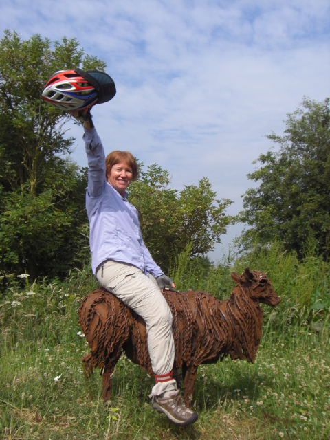
EUROPEAN TOUR 2009 PART IV - ENGLAND
Harwich to Newcastle-upon-Tyne
June 25 to July 11, 2009
Start 54,467 miles (87,147 km) cumulative:
End 55,099 miles (88,158 km) cumulative
TEASERS
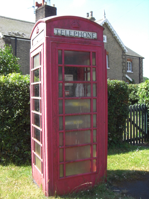
 | Look out! We're riding on the left now.
| Ride along England's Extremely skinny roads.
| Meet and interview with the BBC.
| Tea in Boston anyone?
| Stop by Lincoln's grand gothic cathedral.
| Learn about England's network of foot paths.
| Visit a free transportation museum in hull.
v Stop by the old fishing towns of Robin Hood's Bay and Whitby
| Finish the England ride at the old Roman fort in South Shields.
| | | | | | | |
Section 1
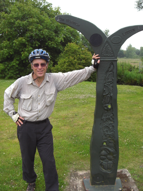
Harwich to Norwich
June 25 - 27
At 5:30 AM sharp the ferry loudspeaker came on loud and clear. Time to get up
and get going.
A quick stop at immigration and we were now back in an English speaking
country, at least a different sort of English than we're used to.
Even though England is part of the EU it still uses the pound currency, has
immigration and passport controls with other EU countries, and still drives on
the left side of the road. It's almost as though they really don't want to
acknowledge they are part of the EU
Riding on the left sure takes some getting used to. We can't begin to count
the number of times we came rolling around a corner to wind up on the right side
or forgot to look left when crossing the street. In fact, our very first few
minutes started with a run-in with a motorist due to just this. We never did
quite get over the tendency to swerve to the right lane.
The other oddity about England is the manner in which they've half taken on
the metric system. Unlike the US which rejects it almost out of hand or Canada
which essentially adopted it overnight, England uses metric for some
measurements and the English system for others. Road distances are in miles.
Prices in the grocery store are in kilograms. One fellow who used to work in the
electronics industry described a cabinet he once worked with that had height,
width, and shelf spacing measured in inches while depth was in millimeters. It's
no wonder engineering mistakes involving units conversions can happen regularly.
Pushing off on the bikes on English roads made us realize quite suddenly that
we were once again back to the reality of biking in the rest of the world. The
Netherlands and Germany are biking paradise. England is very much a car society.
So much so that many drivers seem to feel that bikes are nonexistent. Bike paths
are far and few between. So we really learned to relish those few miles along
those we did encounter.
Also, after the flat riding along Germany's rivers and Holland's canals, our
legs were not in the best condition for England's rolling terrain. England's old
roads date back to the days when everyone traveled around on foot or horse which
did not require 6% grades. The oldest Roman roads literally go straight up and
over every hill along the way. As one chap told us, "When those Romans wanted to
go from point A to point B they went straight over everything in the way" The
Medieval roads went around all the farm fields. The English even have an old
saying that goes something like, "England's rolling roads were built by rolling,
English drunk." For bikers it means some pretty tough riding.
Leaving the ferry port of Harwich, pronounced Harwich by some and Haridge by
others, we decided to make our way through Ipswich rather than take the ferry
across the bay. We were rather shocked to find that the ferry would cost us
around US $20 for a ride of less than 1/4 mile. Clearly unlike Netherlands, this
passenger ferry is not government subsidized.
We worked our way around the Harwich bay stopping in Ipswich just to eat
lunch. We weren't on the signed bike routes yet and wound up dealing with high
traffic roads. It wasn't a pleasant ride. The only campground we knew of that
was near the route was quite a distance beyond Ipswich in a small patch of
National Forest land. Interestingly this proved to be the only campground during
our entire stay in England where they needed coins for the shower.

The next day we got serious about heading north on the North Sea Route.
Almost immediately we picked up the route signs. We were attempting to follow
one of Sustrans (sustainable transportation) National Cycle Routes. These routes
are a very recent creation put together in an attempt to get more people on
bikes. Mostly they travel along tiny back country lanes through farm fields.
When they go through cities you are usually relegated to roads right along with
England's often very aggressive drivers. This wasn't the carefree biking we'd
come to enjoy in Holland and Germany.
Unfortunately we did not have the best maps which made things even more
difficult. The Sustrans bike maps are not nearly as easy to come by as Germany's
Bike Line maps. So we'd just printed them on our computer before leaving the
states. The print outs weren't nearly detailed enough and often we had a heck of
a time keeping on route. Sustrans has placed signs along the way. But, all too
often they miss an important turn, someone removes or tampers with the sign, or
even the road department puts their own signs over the top. The city riding just
wasn't nearly as easy as we would have liked.
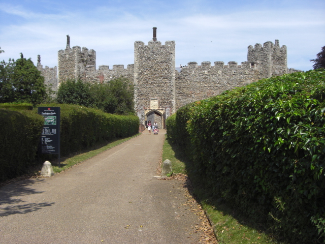
After following along on these skinny roads we stopped in the town of
Framlingham for lunch. Framlingham has a very nice castle that you can visit.
The price to enter is £5.75 per adult which seemed rather steep. However, we
noted that this castle is part of the English Heritage trust. This trust
includes some 400 different sites throughout England. An annual membership costs
around £75 for 2 adults. It gets cheaper if one or both of you are over 60. This
gets you free admission to every site for the year. We're still thinking that
coming over to Europe with a camper of some sort for multiple months would be a
great idea and that membership would be ideal to buy then.
From Framlingham we wound our way through along those super skinny farm
roads, avoiding all but the smallest towns, to the large city of Norwich. It
would have been nice to stop for a day off in Norwich, but as far as we could
tell there were no campgrounds. At least none appeared on our maps nor on our
GPS. So after a quick ride through we continued on to the town of Fakenham.
England has quite a few horse race courses. These race courses often have
camping facilities that are available for use even when there are no races.
Perhaps they see it as a way to earn extra cash to help support the racing
facilities. In any event Fakenham had one of these race course campgrounds we
were headed for.
We arrived late. One thing we discovered about England is that apart from the
new supercenter stores, nearly everything shuts down at around 5 PM. Also, many
of the campgrounds require that you have a key to use the toilet and shower
facilities. So if you arrive late and the office is closed you can just set up
and pay in the morning but you won't get to use the toilet.
Fortunately despite the office being closed we were able to contact the
manager and get a key for the night. But this would not be the last time we'd
have to scramble to get properly checked in after hours.
Section 2
Fakenham to Lincoln
June 28 - July 1
These have to be the skinniest roads we've ever seen. They are so narrow that
cars can't even pass us much less another car. So many times we watched as one
car had to literally drive off the road in order to let another pass. Some were
so skinny the cars could barely pass us. These were old wagon tracks that they
just threw asphalt over and renamed roads.
Yet no matter how remote the road, it seemed there were always at least a few
cars passing. In one case we were traveling along a road in which only the two
tread for the tires were paved. Yet we were still passed by no less that 2 cars
in the mile or so we were on this road. It is very rare for you to be anyplace
in Europe without seeing another person for very long.
England is also famous for its public footpath system. We chatted with an old
farmer and found out a little about how this system of paths came into being.
Back in the old days farmers would take off cross country using the shortest
distance to go visit a neighbor or to go to town. The shortest distance often
meant going out your front door, across your garden, through your garden gate,
across our field, and then through your neighbor's garden and gate to their
front door. It was easy and efficient.
Over time you would wear a series of paths going from your front door
directly to a bunch of different places. Your neighbor would have his own set of
paths, and his neighbor his paths and so on. It was like a huge spider web of
foot paths connecting farm house to farm house, town to town, city to city.
With the creation of the car and the building of the road network the farmers
no longer had a use for these old foot paths.
Now comes along the recreational walkers. Somehow they convinced the
government that these old footpaths created by the farmer across his own land is
actually now a public right-of-way. The farmer or land owner by law may not
obstruct the path and must keep it clear and maintained. And if it happens that
the footpath goes right by your bedroom window, you have to apply for a permit
to relocate the path plus pay a fee to have it rebuilt somewhere else. Wow, talk
about a huge government land grab.
Leaving Fakenham we headed toward the beach resort town of Hunstanton.
Despite being called the North Sea Route we were beginning to realize that this
particular route very rarely actually borders on the ocean. In fact, even
Hunstanton which is on the ocean actually is not officially on the route.
Hunstanton is your typical beach resort town that comes complete with cheesy
attractions. There are carni rides, stalls with games of skill for winning
stuffed animals, food carts, all the stuff you'd expect. The beach is the towns
main attraction, being wide and sandy. Otherwise there wouldn't be much reason
for going there. The campground here was a huge 4 star affair complete with
indoor/outdoor pool, fancy restaurants, grocery store, games room, etc. It was
also the most expensive campground we'd been in to date, a whopping £23. The
facilities were nice and the campsite was nice. But it just didn't seem worth it
for just our little tent. We were beginning to think that the approach taken by
the Europeans of just a tenting area and paying piecemeal for everything may be
a cheaper way to go.
After one short day, we once again had to ride hard and long in order to get
to the next campground. One thing we found with England is a distinct lack of
camping. The coastlines have a fair number of campgrounds especially at the
beach resorts. But inland, camp sites are few and far between. At least along
our bike route that is.
We had not purchased a camping guidebook since we'd be in England only a
couple of weeks. Also, the European campsite data we'd downloaded to our GPS
didn't cover nearly enough sites in England. As a result we found we had to
cover much greater distances each day than we like simply simply to get to the
next campground.
Eventually we did get a very old guidebook from one campground hostess which
helped a bit. Although it did let us down a couple of times when the campgrounds
listed either no longer existed or did not accept tents. In any event, we wound
up roaring through England at a much faster rate than we'd originally expected.
From Hunstanton we wound our way past a place called Sandringham House. This
is one of the many palaces the queen stays in from time to time. You can visit
when they're not in residence. We had to push on because of the distance to the
next campground. We also pushed through King's Lynn and Wisbech with only a
quick stop for lunch. These towns would probably yield some interesting laces to
see, but we just weren't all that excited with them. After another longer day
than we wanted we made our way to the campground in Fleet Hargate.
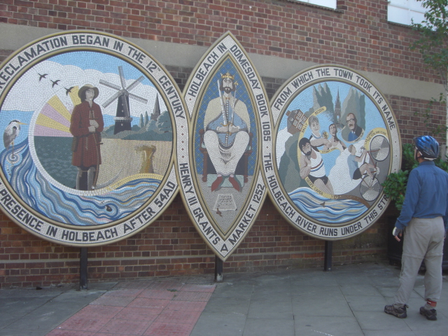
Fleet Hargate is a residential town near the slightly larger town of Holbeach.
Holbeach seemed to be a rather cute town. But you can learn most of its history
from a single mosaic in town. It had Roman beginnings, a few notable events, and
notable figures. In other words, a very sleepy little town.
Upon preparing to leave the campground we were approached by a couple of
ladies from the BBC. They wanted an interview. They were doing a piece on why
people come to visit this region of England. We did the interview, but it's a
little difficult to tell them that the main reason we were there is because it's
on the route. We don't know how much they used of the interview in the end.
Probably just the part showing us riding off down the road. Later I was thinking
that when they asked where we were off to next, I should have said, "Boston, to
see if we can find a little tea." Wonder if they would have gotten the joke?
We, in fact, did go through Boston in just a few more hours. From there we
picked up our first rail bed turned bike trail. Now this was a pleasant section
of riding.
We were riding through the southern Lincolnshire region. This region from
around King's Lynn to the city of Lincoln is known as South Holland. The reason
being, it looks a lot like Holland. It's flat, very nearly at sea level, and
crisscrossed with old canals. There are supposed to be some 90 miles or more of
canals in this area alone.
As in Holland people have taken the old cargo barges and converted them into
live aboard boats. These boats are quite unusual. Some are real narrow, at least
compared to the normal barges. In fact, we learned they are actually called
"narrow boats". We likened them to the shot gun style houses of the Midwest.
They are narrow because some of the canals, locks, and even aqueducts are very
narrow.
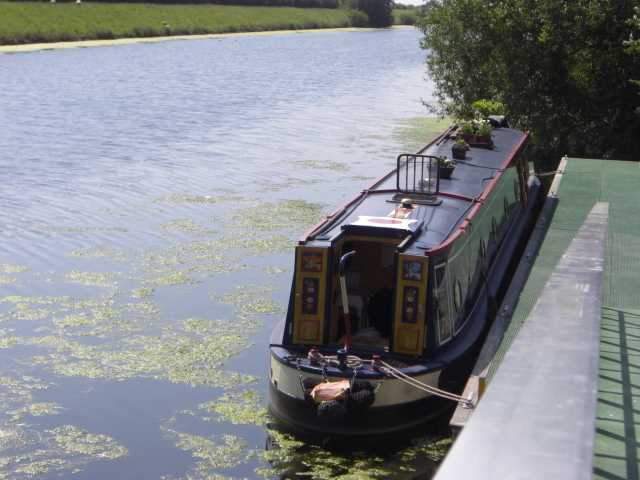
We also heard that when these barges were horse driven, the boat crew would
have to lie on their backs on the roof and walk along the the tunnels to propel
the boat forward. The horses went on the outside of the tunnel and met the boat
at the other end. The old barge crews must have been thrilled to get steam
engines. Of course, they're all diesel engine driven today.
The town of Lincoln was once the seat of government under William the
Conqueror. He conquered, moved in, and built himself a rather nice palace up on
the hill. Opposite the palace is the Lincoln cathedral both of which sit on a
high hill overlooking the surrounding flatlands of the South Holland region. The
approach to this high point is up a steep hill known locally as the "steep
hill."
Buildings surrounding the cathedral are some of the most charming we've seen
in England so far. There's a small precinct of narrow streets lined with half
timbered old homes. They're stuffed into a small corridor between William's
palace gates and the gates to the cathedral grounds.
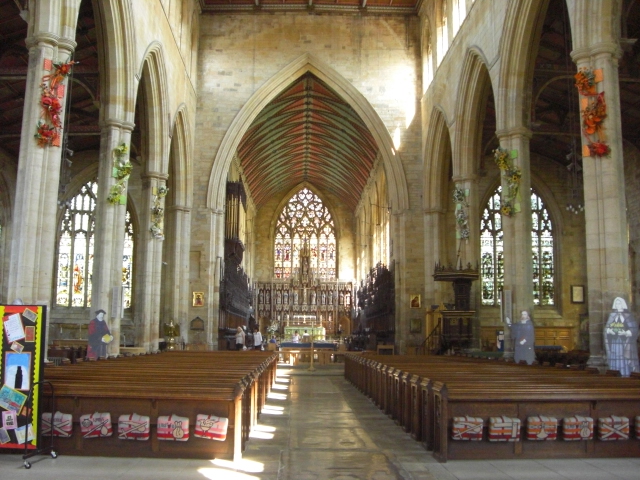
The real pride of Lincoln is its cathedral. This is reputed to be one of
Europe's finest examples of Gothic cathedral construction. This form of Gothic
is most certainly different from the French Gothic we'd seen earlier at Köln.
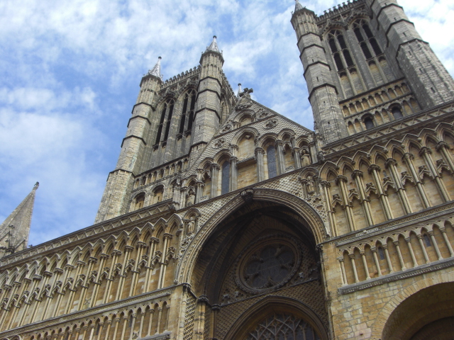
The building is massive. Rather than an impression of a rocket getting ready
to lift off, the Lincoln cathedral seems to be a series of stacked arches. Rows
upon rows of arched colonnades seem to climb up the walls giving the entire
structure a more heavy appearance than the French style. This is all accentuated
by the fact that the twin towers up front are flat topped rather than capped by
those spindly spikes of the French style.
We'd noticed that most of England's Gothic style churches have absolutely
huge windows. In some instances these windows are clear rather than filled with
colored glass. If you look at one of these churches on a sunny day you can
usually see in one window right out the other side to see the sky. Even from the
outside this gives the appearance of almost a gazebo rather than enclosed
building. They really wanted to bring the outside to the inside on these.
Lincoln's cathedral is no exception to this trend.
You can visit part of the cathedral for free. But a trip behind the alter
costs £5 which seems a bit pricey. Since we were once again trying to reach the
next campground before the 5 PM office closing time, we decided to head on.
Besides, this is another of those Heritage sites which we would hope to see as
part of the membership program.
Section 3
Lincoln to Scarborough
July 2 - 6
Once again we wandered along tiny back country farm roads up and down those
blasted English rolling hills. In fact, not too long after leaving Lincoln we
found ourselves climbing the highest point in southeastern England.
In north Lincolnshire there is a long ridge running in a generally northwest
to southeast direction. This ridge is composed entirely of chalk. Chalk is not
an unusual substance for English hills. The White Cliffs of Dover are chalk.
This ridge is known as the Lincolnshire Wolds.
The road we were on was one of those old Roman roads. One of the ones that
goes straight over absolutely anything in its way. So the road doesn't go
diagonally up nor does is switchback. Nooooo. It goes straight up the ridge some
1000 ft and then straight back down. Once over this ridge it was a fairly easy
ride into Kingston-upon-Hull.
We'd been riding long and hard ever since getting to England. Metric
centuries seemed to be becoming the norm rather than the exception as we
struggled to get between campgrounds each day. So finally we decided to take a
day off. Besides, it turns out there are a few free museums in town. So why not
take advantage of that.
Hull, as the city is more commonly known, is the largest city we'd come to so
far. Most of it is a modern, busy town. But there is a very small old town area
right down near the docks. Hull has always been a port city and the old dock
area reflects this.
It's undergone a redevelopment effort in recent decades and much of the
former seedy dockside has been refurbished. This is where you find the museum
quarter which has several rather interesting sites.
The one item we would have liked to see is an old Arctic cod fishing boat
that, unfortunately, wasn't open the day we stopped by. So we chose to visit the
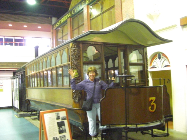
free Street Life and Transportation museum.
This is a well done museum. The main floor is built with the facades of old
1800s buildings making it look like you're standing in the middle of the street
at that time. They have several old trolleys, the double-decker variety, some
train displays, old cars, old carriages, and bunches of old bikes and bike parts
including several old Brooks leather saddles.
What we found absolutely amazing is that back in the 1800s the English used
to be big bicyclists. One small town would have multiple of bicycle shops. Many
of these shops would manufacture their own custom bikes. They all would even
have meeting rooms for the local chapter of the Cycle Touring Club (CTC).
Bicycling was an easy, inexpensive form of entertainment. So folks would
regularly go out on weekday evenings for a ride. People then worked 6 days a
week and it was considered inappropriate to go bike riding on Sunday.
Unfortunately somewhere along the way this cycling culture has been entirely
lost. CTC still exists, although probably nowhere near as strong as it was back
then. When you see the English attitude to biking today it's so hard to believe
it was so different back then.
Although Hull did seem to be one of the first towns we'd seen that was truly
trying to bring back the biking culture. Upon leaving our campsite at Barton we
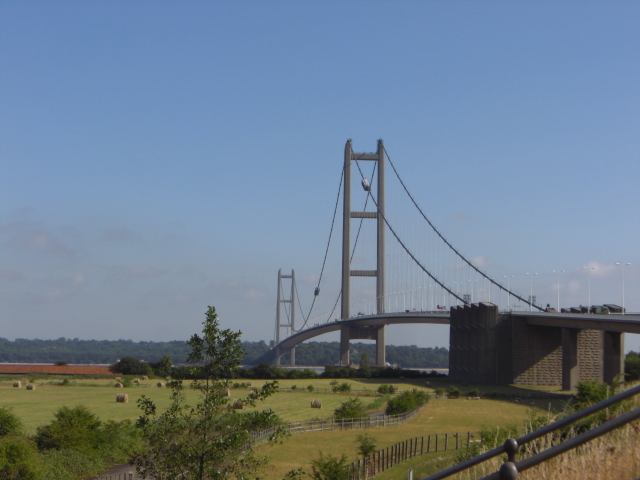
found a very easy bike path that took us up and over the bridge over the river
Hull. Until 1998 this was the largest single span suspension bridge in the
world.
From there they have a reasonably well connected set of bike paths that lead
you down to the old dockside and then back out of town. To take this route did
add probably 10 miles on our day's ride going a fair distance east and then back
west. But without a good map of all the bike routes or the city streets, we were
rather stuck doing this extra mileage.
Once finally out of Hull we stopped at the very pleasant small town of
Beverley to look at their cathedral and have lunch. The Beverley cathedral is
another of the English Gothic style similar to that in Lincoln. It's particular
claim to fame is that it has the most number of statues carved with musical
instruments than any other church in England. Cherubs and angels adorn the false
pillars with flutes, tambourines, guitars, horns, drums, and some contraptions
we can only guess as to their function medieval musical instruments comes right
from this church.
Leaving Beverley in the early afternoon, we pushed on for our third and
longest metric century to arrive at the town of Bridlington, the next campsite
location. It was Saturday evening. There was a volleyball tournament going on at
the beach and the tent sites were full. But t the campground made an exception
to her normal rules. She let us camp in her garden rather than in a campsite. We
must say, the English may get somewhat aggressive when behind the wheel of a
car, but when face-to-face they can be just as nice as can be.
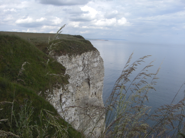
Fortunately from here it was an easy day ride up to Scarborough where, for
the first time since Hunstanton, we were actually on the coast for a while. We
arrived with plenty of time to take a walk along the cliffs by the sea.
Section 4
Scarborough to South Shields
July 6 - 11
Headed north out of Scarborough is one of the very few longer bike trails we
found in England. This is an old railroad track coming from Whitby that has now
been converted into a somewhat primitive bike trail. The surface is unpaved and
can be mucky and rough in spots. But it's level, easy to ride, and in relatively
good condition, although one small mud slide has to be negotiated with care.
It is from this bike trail that we finally got some really good ocean views.
It has amazed us along this North Sea Route in England just how little you
actually get to see the North Sea. Most of our riding to date has been through
rolling farm lands. We've seen fields filled with everything from potatoes to
barely. Yet we just haven't seen much of beaches and blue water.
The rail path climbs at an easy steady rate until it reaches the high point
at Ravenscar. This would be coastal resort was the brainchild of some
entrepreneur. Thinking he could develop a resort similar in size to Scarborough,
he bought up the land, platted and built the streets and lots, built a hotel,
built a brick making factory, and even invested in the railway coming through
town.
Alas the town never quite got off the ground. Today the hotel still exists
and there are a few houses around which all have outstanding ocean views. That's
it.
Heading downhill from Ravenscar you come around a bend in the trail to find
yourself face to face with a fantastic view of Robin Hood's Bay, name for the
bay and the town. It's a place to take a good long break on the convenient bench
before continuing the decline into the town on the opposite side of the bay.
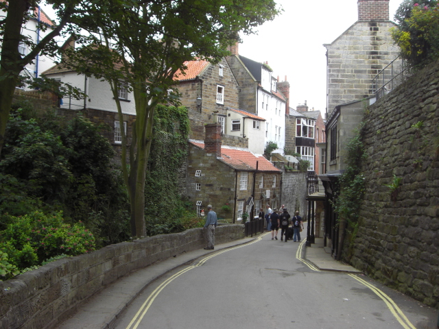
Robin Hood's Bay, the town, is probably the most charming English town we'd
seen so far. This is an old fishing village perched on the steep cliffs
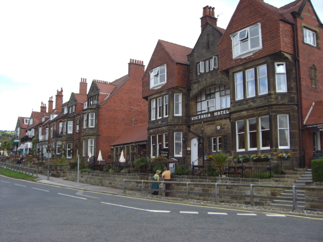
overlooking the bay. In the upper town you find many stately, brick Victorian
style houses in a neat line along the main road into town. These were the homes
of the fishing boat owners.
But the rambling town snaking its way down to the bay is much, much more
interesting. It's got steep, narrow, winding streets bordering both sides of a
small creek. You descend the steep road going past B&Bs, restaurants, and
tourist shops until you find yourself at the small boat ramp at the bottom. Then
there's the steep climb back up. Fortunately there was a parking lot at the top
where we left the bikes so as not to have to push them back up.
From here we continued on to the cute but extremely touristy town of Whitby.
One fellow had recommended that we stop for a visit. Even the guidebooks say
it's worth a look. They say it's a town with a dual personality tourist on one
side and fishing on the other. In reality it's mostly touristy in summer at
least.
We found the only campground really close to town. After some very nice
campgrounds throughout England, this one was quite a let down. It was expensive
and the bath facilities quite lacking in comfort. It's main redeeming feature
was the view overlooking town and it's walking distance to everywhere.
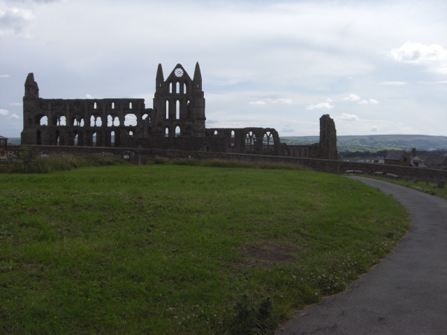
From there we took a wander. First up to St. Hilda's abbey. St. Hilda was
sent to England in 640 to start a church and abbey. First she was in
Middlesborough. Then she founded a second in Whitby. Today the abbey is just a
ghostly looking ruin set high on the hill overlooking the ocean. Interestingly,
this abbey is the setting that inspired the Count Dracula thriller novel.
Back down in town we roamed up and down the picturesque harbor looking at the
arcade attractions that seem so ubiquitous for beach communities. Finally, up
the hill to see the old Victorian hotels overlooking the beach.
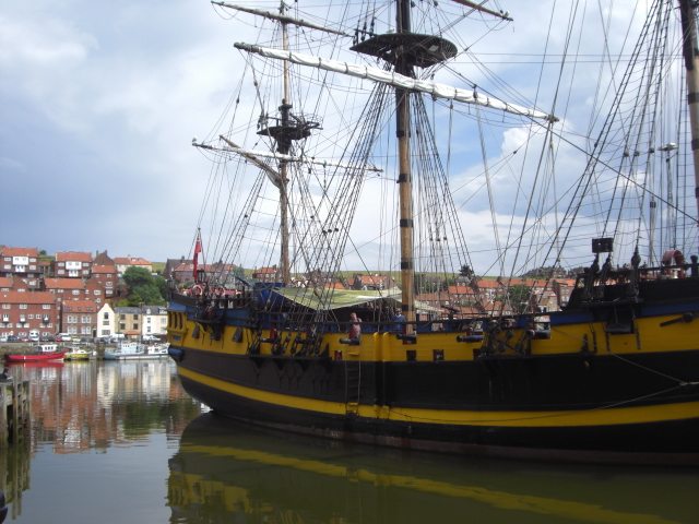
In the harbor they have a beautiful reconstructed tall masted ship called the
Turk. This is a reminder that Whitby used to be a major ship building port. Its
most famous son was a seaman and ship builder. Captain James Cook was born in
the area, grew up in a nearby town called Great Ayton, did his seaman apprentice
work in Whitby, built his boat Endeavor, and set sail.
Leaving Whitby, we took a side road up to the main road and then swung down
to the town of Ruswarp. Rather than being on National Cycle Route 1 at this
point, we found ourselves following route 52. Even though our printed maps
agreed with the route 52 directions we suspect that Route 1 likely stays along
the much flatter coastal roads.
In any event, we were on a route that skirts along the most northern edge of
the North York Moors National Park. Now this is one very, very hilly route. The
road down to Ruswarp had a sign showing a 30% grade ahead. This was all right
for us as we were going downhill. But, soon after leaving the town we found
ourselves on a similarly steep uphill grade on a dirt track going up the other
side. We met a local biker at the top who assured us that the rest of the route
would be much flatter. Of course, he was on an unloaded bike.
Instead we wound up riding 25 miles of rolling hills with many short
stretches of up and down hills having grades of 15, 20, and even 25%. This was
the most thigh burning section of biking we've done all summer.
The route wasn't without interesting scenery. Being at around 55 degrees
north latitude, the tree line is very, very low. In the Moors it almost seems to
be at around 1500 ft elevation. At least the road we were following certainly
looked like it crossed an alpine landscape. Trees and large bushes were
relegated to the lower valleys. The upper slopes of the hills were covered with
just a yellowish/brownish low shrubbery. In most other places it would appear
almost like being at 10,000 ft elevation. Winters must be long here.
We stopped at a town called Great Ayton which, according to our very old
campground guidebook page, was supposed to have a site that accepted tents. Well
we soon found out at the tourist information center that they'd gone upscale and
tents were now out of the question. The only site within a reasonable distance
was in the town of Stockton, across the Tees river from Middlesborough, a
distance of around 8 to 9 miles.
It was still early, around 2:30 PM. So we figured we'd have plenty of time to
get to the campground before 5 PM when we figured the office would close.
All went well for a while. We even managed to take a short cut and still find
the cycle route just at the edge of the city of Middlesborough. We got all the
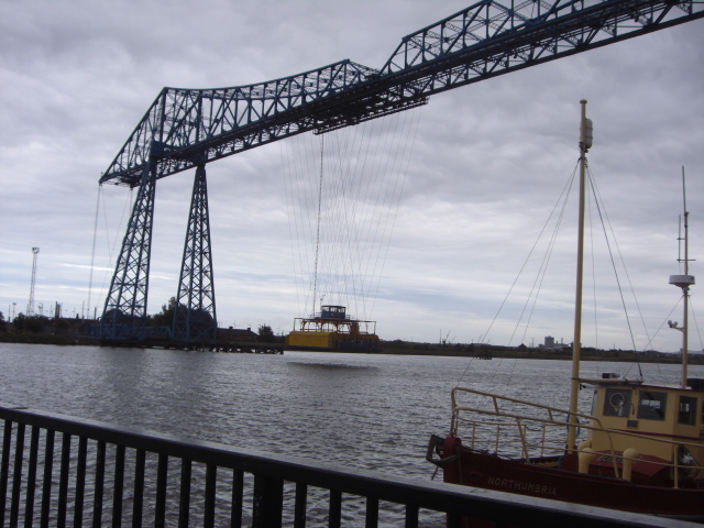
way to the Tees river at the point where the unusual transporter bridge was
located.
The transporter bridge is unusual in that the bridge platform is held by
cables beneath a truss structure. The entire platform moves back and forth
across the river taking passengers and cars with it. The only other example of
such a bridge we know of is in Bilbao, Spain.
From this point things went quite wrong. The campground was located on the
opposite side of the river just 4 km away. Our maps showed the cycle route
headed upstream to some point beyond the major highway where a much smaller
bridge crosses the river. Unfortunately as we headed up river we just could not
find a way to follow the right cycle route. There was construction in the way
and the more we detoured the more off course we got. Going back and forth,
around in circles, and far out of our way it wound up taking us over 1 1/2 hours
to finally find a route through the construction to the campground. It is just
so blasted frustrating to be sitting at a point so close to where we want to be
and simply not being able to find a way to get there.
We pulled into camp tired and testy. It's very clear that England has a long
way to go to achieve the type of cycle culture and infrastructure that Germany
and the Netherlands have. You might say that England is at about the same stage
as the U.S.
We made the next day a very short day. Our legs were sore from the tough hill
climbing of the day before and we were not in the mood for a long, late ride
after the previous day's mess.
We went only as far as the town of Hartlepool (pronounced hart-lee-pool).
Down at the historic quay there is a very interesting and free museum that
covers the history of the town going back some 10,000 years.
Back during the last ice age, England was connected to the rest of Europe by
a land bridge coming in at this point. There was a forest of trees on this land
bridge and humans even lived out there. Evidently at low tide you can walk out a
ways and find old peat bogs and the remains of these old trees. Archeologists
have been exploring these shallow seas looking for signs of humans and have
actually uncovered signs of houses as well as stone implements. This area has
been settled for a long time.
Hartlepool itself is a post medieval settlement. It's seen a lot of boom and
bust periods. It prospered when it had trading rights granted by the king. It
faltered when these trading rights were taken away. It boomed when ship building
was an important part of its economy. It failed when that shipbuilding business
went elsewhere. Now it's trying to reinvent itself as a tourist destination.
They've taken the old quay, renovated the buildings, restored an important old
navy tall sailing ship, and created a living history museum. Boom and bust
cycles have clearly defined this blue collar working class town.
From Hartlepool we had one last fairly easy ride up to South Shields. Out of
Hartlepool there is another of those rail beds turned unpaved bike paths to
follow. This took us into the large city of Sunderland. Once across its river we
finally got onto the coast for a fantastic last ride along the coast up to South
Shields, our most northern point for 2009.
South Shields is also just about the most northern point that the Romans
achieved back in year 400. To protect their claims from the marauding northern
tribes the Romans built a wall extending from just west of South Shields to the
west coast of England. Remains of this wall still exist and it is now known as
Hadrian's Wall.
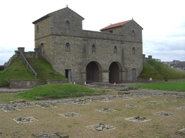
On the hill over South Shields the Romans built a fort. Originally intended
as a defensive fort for the mouth of the river Tyne, they later expanded it by
adding a bunch of granaries. It became the main supply fort for the rest of the
forts along the wall. After the Roman's left the fort was robbed for its stones
and farm fields were planted over it.
Today archeologists have uncovered large parts of the foundations. They were
even working on it when we visited. To give a good sense of what the fort looked
like they've rebuilt one of the gates, one set of barracks, and the commanding
officer's house right on top of the old foundations. It's an interesting site to
visit and is free as well.
It was now time to return to the continent. We'd achieved our objective of
riding from Harwich to the Tyne along the North Sea Route. We booked the
overnight ferry to Ijmuiden in the Netherlands and said our farewells to
England.
APPENDIX A – ROUTE
England
June 25 Side road Harwich to Ramsey. B1352 to Mistley. A137 to Ipswich. Back
road to Tuddenham and Woodbridge. Back road to Melton, A1152 to B1084 to Butley,
71.2 km
June 26 Back roads thru Ikes, Blanhall, St. Andrew, Great Glenham, Swelling,
Framingham, Brabling Green, Peasenhall, Sibon, Halesworth, Holton, Upper Holton,
Cox Common, St. Andrews Ilketshall, to Bungay, 88.82 km
June 27 A143 thru Ditchingham to Ellingham. National cycle route 1 thru Loddon,
Langley with Hartley, Clarton, Bramerton, Norwich, New Costessey, Brayton,
Lenwade, Reepham. Backroad thru Themelthorpe and Foulshem. National cycle route
1 thru Great Ryburgh, Pudding Norton to Fakenham, 100.71 km
June 28 National cycle route 1 thru Little Walsingham, Wighton, Burnham Market
to Ringstead. Side road and A149 to Hunstanton, 53.65 km
June 29 A149 to B1454 to Sedgeford. National cycle route 1 thru Sandering House,
Castle Rising, N Wooton, S Wooton, King's Lynn, W Walton, Wisbech, Tydd St
Giles, Tydd St Mary Gedney Dyke to Fleet Hargate. 103.57 km
June 30 National cycle route 1 thru Holbeach, Holbeach St. Mark, Fosdyke,
Frampton, Boston, Boston West, Langrick, Holland Fen, Chapel Hill, Hawthorn
Hill, to Woodhall Spa. 66.44 km
July 1 National cycle route 1 thru Bardney, Lincoln, Nettleham, Scothern,
Wickenby, Linwood to Market Rasen 78.21 km
July 2 National cycle route 1 thru Thoresway, Swallow, Great Limber,
Barnetby-le-Wold, to Barton upon Humbar, 58.33 km
July 4 National cycle route 1 thru Kingston upon Hull, Cottingham, Beverley,
South Dalton, Hutton Crossing, Driffield, Nettleton, Lowthorpe, Burton Agnes to
Bridington, 107.75 km
July 5 National cycle route 1 thru Bempton, Grendale, Hunmanby, Cayton, to
Scarborough, 45.43 km
July 6 National cycle route 1 thru Robin Hood's Bay to Whitby, 36.43 km
July 7 National cycle route 52 and 65 thruRuswarp, Egton, Lealholm, Danby,
Castleton, Kildale, Great Ayton, Seamer. Shortcut to A 174. National bike route
65 through Middlesbough to Stockton-on-Tees. 89.49 km
July 8 National Cycle Route 14 thru Bilingham, Greatham, Seaton Carew, to
Hartlepool. Side roads to Dalton Piercy. 34.42 km
July 9 Side routes thru Hart. National Cycle route 1 thru Hesleden, Wingate,
South Hetton, and Murton. Cycle route to Ryhope. Route 1 thru Sunderland,
Whitburn to South Shields. 65.01 km
July 11 Campsite to ferry terminal, 11.80 km
APPENDIX B – CAMPSITES
England
June 25: Forest Camping near Butley, Sufolk, (15.00 £/night)
June 26: Outley Mil Campground in Bungay, (9.00 £/night)
June 27: Racecourse at Fakenham, (12.00 £/night)
June 28: Searles caravan resort in Hunstaton: (23.00 £/night)
June 29: Delph Bank Caravan Park in Fleet Hargate: (11.00 £/night)
June 30: Jubilee Park in Woodhall Spa: (8.20 £/night)
July 1: Racecourse camping at Market Rasen: (12.60 £/night)
July 2, 3: Silver Birches at Barton upon Humbar: (10.00 £/night)
July 4: The Poplars Touring Park in Bridlington: (10.00 £/night)
July 5: Scalby Manor Touring, Caravan, Camping club in Scarborough: (14.20
£/night)
July 6: Folly Garden at Whitby: (15.00 £/night)
July 7: White Water park Caravan Club Site in Stockton: (9.80 £/night)
July 8: Ashfield Camping + Caravan Park in Dalton Piercy: (10.00£/night)
July 9, 10: Lizard Lane Camping + Caravan Park in South Shields: (10.00 £/night)
July 11: Ferry to Amsterdam: (234.00 £)
|