| Caryl and Brian's World Bike Tour |
|
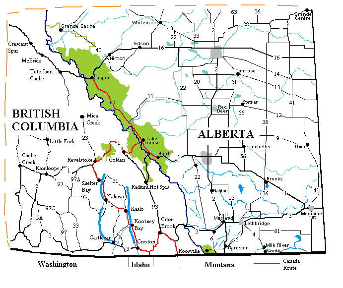
Great Divide Bicycle Route 2000 (Canada) |
![]()
![]()
![]()
|
|
GREAT DIVIDE BIKE ROUTE - CANADA Jasper, AB to Eureka, MT June 4 to July 7, 2000 30,316 miles (48,506 km) cumulative
Teasers:
"Travel itself is part of some longer continuity." View PhotosBlinking furiously, we descended from the Greyhound bus into the startling sunlight of early morning June 4, 2000 in Jasper, Albert, Canada. Jagged gray peaks footed in cool green forests and crowned with crystal white icing greeted us from every side. Fine streaks of orange and pink left over from a spectacular morning sunrise were rapidly giving way to pale yellow and then brilliant blue of the northern, high altitude sky. We shivered in the crisp, cold morning air as we unceremoniously dumped boxes of bikes and equipment at the rear of the train depot. Brian stayed to sip coffee and guard our precious belongings while I hunted down bananas from the small Winks convenience store around the corner. Our 2 1/2 day bus ordeal had finally come to an end. I believe Harry Chapin once wrote a song about taking a Greyhound bus trip. In it he describes towns he passes, passengers who come and go, and greasy spoon cafes he endures. At the end of the journey he concludes , "It's the going, not the getting there, that's got to be good." Now we've traveled via mass transportation throughout the world. Taken 1 to 2 day bus trips throughout Mexico, Guatemala, eastern Europe, Turkey. Yet nowhere have we had as uncomfortable, unpleasant an experience. The seats are cramped and as hard as boards. There's no movie, as you have in Mexico, no beverage, as you get in Turkey, and almost no breaks for meals as they do everywhere else. During the 32 hour stint from LA to Seattle we had only 3 stops that were longer than 5 to 10 minutes. In Phoenix we watched an INS inspector pull an illegal alien from one bus. From LA to Portland we sat next to a man wearing what could best be described as a ragged piece of potato sack pinned at the edges to make a skirt. In Vancouver some hard rocker types with blue hair, black silver studded leather, and pierced everything begged for money. We had to physically switch our gigantic boxes from one bus to another in Lordsburg, LA, Seattle, and Vancouver, we had to argue about the cost of the bikes in Seattle and Vancouver, and we had to fight to have our Seattle to Vancouver tickets reissued after the LA driver took them. Granted, Greyhound did deliver what they promised. They got us and our bikes from Deming, NM to Jasper, AB in 2 days, 15 hours, and 10 minutes as promised. But, we have to agree with Harry Chapin. Next time we'll look at renting a car. We had arrived; safe, sound, exhausted, and only slightly worse for the wear. What a change from Deming, NM. Brown hills, searing 100 plus temperatures, arid air that gives static cling to every move had given way to gorgeous greenery and pleasant chilly temperatures. In the previous week we had been forced to make the sudden change of plans, completely reversing our summer travels. New Mexico was in the midst of a 2 year long drought. The mountains were parched, springs, creeks, and rivers were nothing more than sweeps of sand, spring temperatures were soaring into the 100s more than a month ahead of schedule, and forests were burning. After much soul searching and getting advice from the locals we concluded that spending over a month struggling through the difficult and dry southern terrain in the searing heat would be, quite simply, not fun. Contrary to what many folks may believe, we really are not into self torture. So even though we really had wanted to ride south to north, thus saving the best for last, we would have to upend our plans simply to deal with the weather. Oh well, in the end we'll probably be much happier since for the first time we'll not be pushed by oncoming fall weather while on a north to south route. We have until mid October before the first freeze MIGHT hit Silver City. This means lots and lots of time.
"Nature distributes her favors unequally."
The Canadian Rockies surrounding the tiny, tourist town of Jasper, Alberta has been given far more than her fair share of nature's favors. So far we have found no place in North America within easy road access that comes even close. Town is located just a few Km east from one of the lowest and easiest passes of the Canadian Rockies, the Yellowhead Pass. Consequently it is a major east/west transportation corridor. Canadian highway 16 is the primary road leading from the eastern cities up to the port at Prince Rupert. In addition, the railroad passes through the town. Every day huge freight trains, 10, 20, 30 cars long pass just to the south of town. Town has just 2 main streets, each a few blocks long and lined with shops and restaurants catering to the tourist. The highlight is the beautiful stone and wood bedecked Parks Canada information office. Built in 1914 from locally obtained glacier smoothed rocks and timber, it housed the first park superintendent, Lt. Col. Maynard S. Rogers. It's architecture set the standard for the rest of the village such that today examples of rock and timber structures can be seen on every street. Today the house is the first stop for anyone seeking information about the park, the town, or about Alberta in general. The beautiful lawns and gardens surrounding the house have become the main place to relax, lay about, read, gossip, see, and be seen. Scores of back packers cover the lawn, their packs acting as makeshift chairs or pillows. The town, Jasper, and the park within which it sits were both named for a former fur trading post called the Jasper House, named for Jasper Hawse an 1800s manager of the post. But the route over the pass was little more than horse and foot trails. It was not until 1911 that the transCanadian railroads came to the area. Two lines, the Grand Trunk Pacific and Canadian Northern, competing for the same business, built parallel lines over the pass. In the 20s the two lines were merged becoming the Canadian National Railway and the parallel tracks were also merged. The first car appeared around 1915 or 1916 having been shipped in by rail. Rogers, being a strict military disciplinarian, declared that the Jasper National Park was no place for one of these new fangeled machines. He had his rangers hunt it down, capture it, drag it back to Jasper, and put it on the next train headed out. Needless to say by 1920 even Rogers had succumbed to the comforts of an automobile. In 1931 a dirt road was completed connecting Edmonton to Jasper and the onslaught of cars began. The Icefields Parkway was built as a depression relief program in the 1930s and subsequently rebuilt in the 1960s. In the 1950s Fred Baxter, one of the locally famous Baxter brothers whose business even today provides bus tour services, began clearing paths for the downhill ski resort. Today Jasper National Park, the Icefields Parkway, the town of Jasper, and the brand new 1996 Icefields Center play host to well over a million visitors each year, summer and winter. It's one of the most popular of Canada's vacation destinations.Jasper townsite is one place that draws us again and again. It's tucked among glacier carved mountains looking like jagged serrated knives lying edge up or three sided pyramids, hence the name for Pyramid mountain. There's so much to do, so much to see. We've ridden the tramway to get a fantastic overview, we've hiked the low hills behind town, ridden some of the local biking/hiking trails, and taking a day long 60 mile ride up to Lake Maligne (ma-li-nee). Mysterious Lake Maligne was once considered to be a lost, unmapped lake. Local natives told of it, but white man never found it. It took a group under the guidance of a woman, Mary Shaffer, to finally find and map it in 1908. Nestled at the base of glacier sculpted mountains, it quickly became a tourist destination in its own right. "Curley" Philips set up a camp complete with rental boats. Today a brand new chalet/restaurant/giftshop and parking lots occupy the location of the former camp. Only the historic boat house remains from where you can still rent canoes and kayaks. For those not wanting to be self propelled, there are tour boats leaving every hour. Tour costs are $32 Cdn per adult. We forego the boats and struck out on a short lakeside hike instead. Jasper, Banff, and the Icefields parkway are not actually part of Adventure Cycling Association's Great Divide Mountain Bike Route (GDMBR). But, knowing how wonderful the parks are, what spectacular scenery there is, how terrific the biking is we just couldn't resist riding the route again, the third time. Although this time we'll be seeing the road from north to south for a change of perspective. Jasper National Park, at the northern end of the parkway, was established in 1907, covers an area of 10,878 square km (4,199 square mi), and is the most northerly of the 6 Canadian mountain parks. The highest peak is Mt. Brazeau at 3470 m whereas the highest elevations we will achieve along the Icefields Parkway are 2055 m at Sunwapta pass (meaning turbulent water in native language) and the 2088 m Bow summit. The other 5 Canadian mountain parks are; Banff, 6,641 sq. km., bordering Jasper to the south; Kootenay, 1,406 sq. km adjacent to Banff on it's west side; Yoho, 1,310 sq. km., directly west of Jasper, and Glacier, 1,350 sq. km, and Mt. Revelstoke, 260 sq. km, both located further west of Yoho. These 6 national parks combined with additional adjacent provincial parks, county parks, and wilderness areas results in an ecological zone covering thousands of sq. km. Needless to say wildlife abounds and it doesn't require too long a visit before you spotted several of the regions largest and smallest species. In fact, during the week we spent riding from Jasper to Banff we spotted at least 4 moose, many elk and deer, one porcupine, lots sheep and goats, far too many marmots, squirrels, and chipmunks to count, and 7 bears, 4 brown and 3 grizzly. We concluded that although June may be notoriously cold and rainy, it's definitely the best time of year for seeing the natives. After playing around Jasper for a few days, getting recovered from that long arduous bus ride, we finally decided it was time to head south. Unfortunately, nature simultaneously decided it was time for the good weather to end. We left amid gray skies, thick, low clouds dragged across the rugged mountains permitting only occasional glimpses of the spectacular glacier carved peaks. We rode 50 km with an ascent of 300 m to arrive at the beautiful mountain lake aptly called Honeymoon lake. It was here that cold drizzle engulfed our supper preparations. It was here we spent 4 long hours shivering as we tried to prepare supper. It was here that the saga of the stoves began. Ah yes, when will we learn to trust our instincts on equipment selection. Throughout 1999 we used our gasoline burning MSR Dragonfly stove with absolute success. It worked like a charm throughout eastern Europe, places we were convinced would have gas of questionable quality. The biggest drawback of the Dragonfly is the fuel. Two 22 oz. bottles of fuel may last up to 2 weeks at most, 1 week if we're boiling a lot of very cold water. For normal road touring the weight and availability of fuel is not a concern. However, for the GDMBR we wanted to try to eliminate our dependence on gas stations. So we bought another stove. It was an aluminum, cylindrical shaped wood burning stove called the Sierra stove. It highly recommended by a bike tourist who rode from Alaska to Florida depending upon this stove the whole way. According to directions written on the Sierra stove, you simply start a small fire in the cylinder using tinder, turned on the battery run blower fan located under the cylinder, added more fuel, and, voila!, you have an 18,000 BTU burning inferno that can boil water in no more than 10 minutes. Theoretically that is. What we discovered on that cold wet night was that this high level of performance only happens under ideal circumstances; the wood is dry, it's a heavy oak not light pine, the water starts at 70 degrees, the air is correspondingly warm, and you're only trying to boil 1 liter/1 qt at a time. On that night we found it took no less than 1/2 to 3/4 hour to boil our 2 liters of near ice cold water. Add to that the fact that the stove cylinder wobbles on the fan base making for a woefully unstable cooking platform, that pine wood leaves a black sticky goo covering the pots that gets all over hands, bags, and everything else, that once the cylinder fills with ash you have to stop cooking, empty it, and start all over from scratch, and that you spend the entire dinner hour(s) hunting down more twigs to fuel the ever hungry fire. That night we had to restart our fire 2 times and used at least 2 plastic bags of wood. After that one awful evening of struggling to get a hot meal we'd had enough. This stove was the worst bike touring stove we'd ever encountered. It might be good for long, long backpacking trips where weight is more critical, but it makes no sense for biking. Next morning, another unpleasantly cold, drizzly day, we decided to ride, unloaded, the 50 km distance and 300 m down to Jasper to buy a new stove. Pedaling hard and fast we managed to make the trip in around 2 hours. A quick search around town and we found a small, inexpensive, canister style stove. One more stop netted us a large canister and we were set. Two and a half hours later we'd reridden the 50 km and 300 m back to Honeymoon Lake making a total distance of 65 miles for the day. We were beat, but at last we'd have a quick and easy hot dinner Or so we thought. Upon trying to attach stove to canister, Brian discovers that ... all canisters are not the same. This particular stove requires, will only fit, screws into one particular brand of canister and none other. "Damn, damn, damn!" Brian exclaims, "I'm not going on with that damn Sierra stove and we can't use this other. We have to go back." That night we once again fired up the Sierra for one more tortuous, 3 hour long dinner cooking session. The next morning we packed up our tent, sleeping bags, and few other belongings needed for camping, locked our extra food in the bear locker, and rode back to Jasper, again. Another search and we found the one and only store in town that carried the MSR stove line and they happened to have our favorite, Dragonfly. We bought one, at a tourist area inflated price, which now means we have 2, one sitting uselessly in New Mexico. Oh well, tis better to have a stove than not. This time we left nothing to chance. We got gas and food, then spent the night right at the Jasper campground where we gave the new stove a thorough test run. It performed flawlessly. Over the next 4 days we returned once again to Honeymoon lake for one last night and to pick up our gear, and then continued south over Sunwapta and Bow passes. Our new stove ran great, boiling pot after pot of cold water as we downed cups of hot drinks in an attempt to keep warm. That is, until we reached Mosquito Lake just north of Jasper. Suddenly, without warning, the new stove simply quit. No flame, no heat, nada. It's a field serviceable stove, meaning you can take it apart to be cleaned. So we took it apart. We took everything apart; the jet, the flame adjuster, the on/off knob, the pump, everything that could come unscrewed we took off. We cleaned, cleaned, and cleaned. Yet, when put back together, the stove would hiss to life for about 30 seconds and then sput out again. Dinner that night, as flecks of snow fell all round, consisted of cold tortilla sandwiches. This time we headed on to Lake Louise where, much to our delight, we discovered that the one and only outdoor store did, in fact, carry MSR and had Dragonfly stoves in stock. One call to the MSR representative and all was straightened out. We would be leaving with another new stove. Evidently they are not aware of problems with Canadian gas as compared with US gas. The stove may require more cleaning, but it should work. So there had to be a problem with the stove. But just to be on the safe side, we decided to buy white gas at least until we leave the Canadian mountains as there may be some strange additive used only in Canada unleaded gas and maybe only in winter and maybe only in the mountains. We have now learned several lessons. First, always treat equipment recommendations with a great deal of skepticism if they come from newbie bike tourists. The likelihood that they've used that equipment in every conceivable situation is remote. Second, use similar cautions with equipment recommendations from someone who received the item from a "sponsor" no matter what their experience. No matter what they may claim, their opinion will be biased. Finally, carry a spare stove. Cold suppers on cold, rainy nights are a biker's nightmare. After this summer we'll carry our old MSR Whisperlite International 600 as a back-up. Well, one conciliation, if we didn't experiment with our equipment we'd never find our what works and what doesn't. So thus ends the saga of the stoves.
"If we had no winter the spring would not be so pleasant: if we did not sometimes taste of adversity, prosperity would not be so welcome."
Canada's Icefields Parkway traces along 230 km of spectacular scenery between the park towns of Jasper and Lake Louise. It follows up and down 4 river valleys, crosses over 2 passes, and parallels the continental divide for most of its length. From the road it is possible to view the most number of glaciers than any other road in North America and possibly the world. Athabasca Glacier is the most famous as it is closest to the road and easily accessible. In fact, for a mere $25.95 Cdn per adult you can get a snow coach ride up to and on the glacier itself. Athabasca and 6 other glaciers descend from the enormous Columbia Icefield. With over 325 sq. km. surface area and over 10 stories in depth it is the largest icefield not only in the Canadian Rockies but in North America. If you were have a party on top of the icefield and you gave 1 sq. m. to each person you could put the entire population of N. America on that icefield. There's enough ice to make 1 billion, billion ice cubes, a whole lot of ice tea. From the road you can just see some of the icefield coating the crests of the mountains. It appears as a thick layer of pure white icing lying across the peaks. We met a couple who, for their honeymoon 40 years ago, came to the parkway and took the old, original style snow coach ride. "It was little more than a small red truck with tractors." she said, "They slid down this hill onto the glacier. There were snow banks in its path to slow it down. They didn't have anything like those big buses they have today." Today a huge Icefield Center sits majestically in the high alpine meadow at the foot of the glacier. Its exterior architecture is modeled after the fabulous park lodges of old, gray stone with ornate wood work. But inside, the main level is a busy, modern hub of activity resembling more a waiting area in Disney than a park lodge. In one respect it's lost a lot of the subdued character of the old lodge. However, as one park employee told us, "That 'character' no longer flows down the river as they've installed a completely enclosed water system." The old lodge, while more charming, was built to handle only a few hundred thousand tourists per year, not the millions who descend upon it today. The valleys through which the parkway passes were formed by continental uplift followed by glacier carving and now rivers continue the cutting process. Consequently there were ragged, gray, snow decorated peaks over both our left and right shoulders. Each bend in the road brought new, spectacular vistas. We took our time along the Icefield Parkway, apart from the rides back and forth between Jasper and Honeymoon Lake, 3 days to get to Sunwapta Pass, 3 more to get to Lake Louise, and one to Banff. Despite the cold and rain we still found the route as magical as ever. June 17th we arrived in Banff, the crowded, busy tourist center from which all the tour bus traffic emanates. At the end of the 19th century, Banff was little more than a wood shack town consisting of just a few permanent buildings. But, while constructing the rail, a few rail men discovered a natural hot spring steaming from the hillside that now overlooks the town. Being the entrepreneurial types, they immediately set up a small lodge and charged folks to come partake of the healing waters. Recognizing the potential value of the area and the damage overactive development could cause, the government soon stepped in and in 1885 established the spring and a few surrounding acres as Canada's first national part. It was the world's third such designated area, Yellowstone being first. Despite preservation, development continued anyway. The railroad soon built one of their famous and very large park lodges overlooking a set of overgrown rapids in the Bow River that somehow earned the name Bow Falls. The Banff Springs Lodge remains today as the most prestigious set of accommodations available. It is an enormous brown brick edifice with steep sloping green roofs reminiscent of many of France's old chateaux. Unfortunately the relaxed and slow pace enjoyed by the wealthy patrons of the past has long since evaporated. Today, tour buses shuttle people in and out at breakneck speeds leaving one with the impression of an assembly line process. The actual town of Banff was named after Banffshire, Scotland, birthplace for two of the railroad's major financiers. The downtown area seems to center along one main street, Banff Ave. Lined with restaurants, trinket shops, and hotels this is the street most tourists see and never stray beyond. Yet, a quieter side of Banff can be discovered simply by heading one block west. Here is where one finds the camping equipment stores, bike shops, hardware stores, grocery stores, library, town hall, and post office. Here is where one finds the locals and where we spent much of our time restocking our food supplies. Ten years ago when we first visited Banff we didn't much care for the overcrowded tourist town. Having now discovered the "real" part of town we reckon it's not quite as bad as we recall. However, we still prefer the smaller and less busy town of Jasper We took 2 days of rest at the Tunnel Mountain II campground in Banff. It's named Tunnel Mountain because the railroad surveyors originally called for a tunnel to be built through it. A subsequent survey rerouted the rail up the Bow River Valley to the north thus eliminating the need for a costly tunnel. But the name stuck. Access to town is real easy, a trolley style bus comes by every 1/2 hour and costs just $1 Cdn for each one-way 15 minute ride. Otherwise by bike it'd be a fast descent into town and a long climb back. Since we chose to make our 2 days a complete rest from the bikes, we took the trolley or walked. The day before the summer solstice, when the air seemed to finally smell of summer and the sun gave us some warming rays for the first time in over a week, we left Banff To the east of Banff across from Trans Canada Rt 1 is the beautiful lake Minniwanka. It's an artificial lake, having been dammed in the 1920s and the level further raised in the 1950s. We're told there are remnants of the community of Minniwanka carefully preserved beneath the waters of the 1950 level. Further below the dam is another abandoned town. Bankhead was a company town created by the Canadian Pacific Railway solely to mine the rich deposits of coal located in the adjacent mountains. The mine was created in 1903 and the town founded in 1905, surprisingly after the formation of the National Park. At that time the park saw the coal mine operations as a means of bringing in funds to a cash poor park system and besides no one seemed to mind anyway. In the 20s the bottom fell out of the coal market. Combined with a miners strike and the fact that this particular mine was never all that profitable, the railway decided to close the mine in 1922. By this time attitudes towards the park had more conservation rather than exploitation bias. So not only was the mine closed, but the entire town was eliminated. Thirty-eight residential buildings were loaded onto trucks and carted off to Banff, Calgary, and Canmore in a record setting 40 days. The mine buildings were destroyed, tracks removed, and mine tunnels sealed with explosives. All that remains today are some concrete foundations that will slowly turn to dust, the transformer building that houses a few exhibits, a few pieces of machinery, parts of a compressed air driven mine train, lots and lots of coal dust and tailings, and wild rhubarb plants that escaped from the now long abandoned Chinese gardens. Memories also remain as there are still a few former Bankhead residents alive today. Bow Valley Parkway, part of the original TransCanadian highway, traces a gently curving path along the northeast side of the wide U shaped glacier carved valley. As contrasted with the new Rt 1, which takes a flatter, more direct path up the opposite side of the valley, it's a peaceful, quiet, and slower moving 2 lane country road. Cars are here to enjoy the scenery, not simply move from spot A to B. The southern section, which departs Rt 1 about 5 miles north of Banff, is relatively flat as it follows north along the Bow river valley. The only real climb comes at the Hillsdale slide. It's a huge rock slide formed after the mountainside, left water soaked after the glacier retreated, fell down into the valley below. Here the southward bound lane takes a flatter path while the northward route heads to the top of the old slide and back down. Towards the north end of the parkway the hills start to grow as the road climbs to the higher elevation levels of Lake Louise village. All along the route interpretation signs point out interesting geological and landscape features. The most interesting is a series of 4 3D models located at the southern end. These show how the valley formed through uplifting, river carving, continental collisions, and glacier sculpting. It shows why the mountains in the south half of the valley are gray in color and highly slanted versus those in the north that are brown and flat topped. The one "must see" of the parkway is the hike up Johnston Canyon. This 2.5 km hike to the upper falls follows a path right within the walls of the shear sided canyon. Catwalks, I counted 6, are precariously suspended within the canyon. As you walk you have nothing but rock on one shoulder, raging river on the other, and air below your feet. At the lower falls you cross the river on a bridge, duck through a tunnel in the canyon wall, and appear out on a rock ledge having a direct view of the falls. At the upper falls a catwalk takes you out to a platform seemingly suspended in mid air right over the center of the river. It's a hike not for the squeamish. But, for the adventurous, don't miss it. The small village of Lake Louise, located at the northern end of Bow Valley Parkway, is nothing more than a tourist service center. One of Canada's largest downhill ski resorts, Marmot, is located in the mountains just facing town. It comprises mostly hotels, but there is a small and expensive grocery, an outdoor store, book store, photo store, and some restaurants. It's a place to pick up a few necessities, not stock up on supplies. The outdoor store, however, does seem to have reasonable prices. We stopped in Lake Louise on our return from Banff not because we planned to, we had no choice. Protection Mount Campground, located about 8 miles south on the Bow valley parkway, had been open when we rode by days earlier. So we planned to camp there. To our surprise we found it closed. Turns out they only opened it temporarily because Lake Louise was closed to tenters. Two amorous grizzlies had been using the campground for their playground. Now they had reopened the Lake Louise campground and closed Protection Mount. So we wound up at Lake Louise again. Well, it is a nice place to get a shower. In 1858 a man by the name of James Hector was tasked by the Canada Pacific Railway to survey the passes just west of Lake Louise. So he and his survey team headed off into the mountains. Somewhere along the way his horse became vexed with him. Perhaps he didn't like the food, or maybe the rough terrain, or perhaps James Hector himself. Well, one day the horse had had enough and he kicked Hector right in the head. Knocked him unconscious he did. So to this day this momentous event, at least in Hector's life, is remembered in the names of Kicking Horse Pass and Kicking Horse River. What Hector found on the west side of the mountains was little to impress the railroad construction engineers. As opposed to the Bow River valley with its broad U shape, the west side, now within Yoho National Park, is characterized by narrow river cut V valleys. The western approach to the pass is narrow and steep. In addition, it's wetter meaning a heck of a lot of snow in the winter. Thus it was in the best judgement of the survey team that Canada's first transcontinental railroad be built through the Yellowhead Pass to the north. Did the railway bigwigs and politicians listen? Of course not. This was the 1870s and 1880s and the border between the US and Canada was still hotly contested. An Independent judge had much earlier ruled that Vancouver Island belonged to Canada and the San Juan islands to the US. But territory on the mainland was still up for grabs. By this time the Americans had already pushed through their first transcontinental railroad taking advantage of the less formidable Rocky Mountain crossings available to the south. Being the ever constant opportunists, the Americans were quick to send spur lines up into western Canada through the north/south running valleys between mountain ranges. Thus goods from west of the Rockies started flowing south to the states making for stronger ties to the states than Canada. To stem the tide, the Canadian powers-that-be wanted to place a rail line across the most southern mountain pass possible. The easier Yellowhead was too far north and the Crowsnest was still within disputed territory. This left only the Engineer's nightmare, Kicking Horse and then the further west nightmare, Rogers Pass. It took several years for them to cut, saw, blast, and grade a route through the two passes. In Kicking Horse they wound up with a 4.5% grade, twice the normal. This meant that in the beginning it took 4 steam locomotives to pull just 14 freight cars up the grade. The downhill was quite a ride, if you lost your brakes that is. Runaway trains, boiler explosions, derailments were all too common. In fact, we understand that the men on the very first train through the pass all died from such an accident. It took 25 years and an unusual technique for them to resolve the problem. To reduce the grade they needed to put in one long switchback in the middle of the climb. But, the only place they could make the turn at the end of each switchback was inside the mountain. That's what they did. They cut 2 spiral tunnels, each making around 288 degree turns, deep inside the mountain. Today trains having over 100 cars can trudge up the gentler 2.2% grade and, if they're long enough, they'll cross themselves twice. The problem with the Rogers pass wasn't so much the steep grade as it was the dangerous avalanches. It has to be one of the steepest V valleys that is used as a major transportation corridor in the world. As you ride or drive up Trans Canada Rt. 1 nearly vertical rock mountains come down to the road on both sides. Needless to say, snow doesn't stay put on those barren, steep rock faces. The railroad, finished in 1885, had to use snow sheds to keep avalanches from blocking the rails. There were a total of 31 wood and stone snow sheds of 6 different styles depending upon location. Even still keeping the sheds maintained and the rail open was a constant and sometimes deadly chore. On March 4, 1910 a work crew was out clearing an earlier snow slide when another avalanche fell. Sixty-two men were buried alive. That was the last straw for CPR. Six years later they had finished digging the longest tunnel along the entire TransCanada route right under Rogers pass thus eliminating the worst of the avalanche threat for the rail at least. In 1962 TransCanada Rt 1 was built. In Rogers pass it follows along the old rail route. It is the longest stretch of road under active avalanche control in the world. On the eastern approach there are 6 concrete snow sheds wide and tall enough to accommodate 1 lane of truck and vehicle traffic each way. In winter the Canadian army is called out. They haul these 105 mm howitzers to several predetermined locations, aim at predefined avalanche trigger spots, and fire off enough rounds to bring the mound of snow down. Oh, they do close the road during this process. This periodic road closure to blast the snow goes on all winter long, day and night, snow or shine, and particularly during the worst kinds of weather. All this is done so that the great wheels of commerce and trade can get through and an occasional skier as well. From Lake Louise we had only a short hop up to Kicking Horse Pass on the now closed to car traffic, former Rt 1A. Ah what a delight to leave the cars and tour buses behind, at least for a few miles. There's even an abandoned picnic area now accessible to only bikers and hikers. Kicking Horse pass would be the first of our many summer Continental Divide crossings. To make the crossing even more poignant, there's a small stream that makes a perfect Y split. Water heading down the right fork takes the long 2550 km trip to the Atlantic ocean whereas the water on the left has a shorter 1950 km trip to the Pacific via the mighty Columbia. There are few creeks in the world whose waters wind up in two separate oceans so far apart. We flew down from the pass stopping briefly to watch a train enter and leave the spiral tunnels. As we continued an icy rain fell, feeling like stinging needles on the hand. We were lucky as we missed the worst of the rain. We just barely got wet enough to be chilled, but not drenched. After we'd pulled into Kicking Horse campground the clouds parted, the sun came out, and we were treated to a fabulous evening sunset with wonderful views of the surrounding jagged peaks. Every so often we happen across a campsite that is so special that it remains in our memory for years after we stayed. The Juneau campsite overlooking the glacier, the Haines, Alaska campsite overlooking the inside passage with bald eagles circling overhead, or the Utah mountainside where we had a spectacular sunset all to ourselves. To this list we have to add the Chancellor Peak campground. Just a few short miles further downhill from Kicking Horse campground, it's located along a preserved section of the old Rt. 1. Campsites positioned right on the banks of the Kicking Horse River have an absolutely unobstructed view of the turquoise colored glacier silt laden river and the glacier and snow capped, craggy mountains in the distance. Our dinner table was positioned so that we had the maximum effect of the view. Conversation lagged as we stared with awe at the beauty around. "It doesn't get any better than this." Brian exclaimed.
"Mountains are the altars of the Gods."
From the Chancellor Peak campsite, Rt 1 bends around to the north to continue a long descent between steep canyon walls. There's little room for the 2 lane road in this section and no room for the wide shoulders we'd come to know and love. This is perhaps the most worrisome and treacherous section of the highway. If we'd been flying downhill throughout it wouldn't have been quite so bad. But there were several uphill sections. Combined with a good headwind and the belching, coughing of lots of passing trucks and it became one long, arduous ride. We were so relieved to finally see the streets of the town of Golden stretched out below. From now on we don't expect to find ourselves on any similar such road. In Golden we quickly restocked our food supplies, washed our very dirty clothes, and continued west on Rt. 1 towards Rogers Pass. What a climb. The elevation at Golden is 790 m and the pass is at 1330 m making for a total gain of 540 m, or around 1500 ft. Not so bad a climb except for the fact that we essentially did it twice. First you ride up out of the Columbia river valley climbing at least 1200 ft or more. Then you descend back to river level. You begin the final assault on the pass no more than 5 miles from its peak. I can see why it was such a steep grade for the trains to huff up. As you near the pass from the east side you have to ride through the 6 snowsheds. There's not much more frightening than having to ride up a steep hill through the dark interior of a tunnel with tons of traffic all around. Fortunately our red strobe lights on the rear of our racks do seem to catch driver's attention as they did move over. Exhausted, we weaved our way into the parking lot of the Rogers Pass center and plopped ourselves down for a rest. We are starting to long for the quiet solitude of the forest service dirt roads, for isolated campsites we choose simply by deciding to stop for the night, of roads that are challenging and yet beautiful to ride. We grow weary of the hundreds of cars, trucks, and tour buses that pass us each day, the rental RVs that are all filled with German's paying a whopping $800 USD per week not including gas, the full campgrounds, the busy hiking trails. Summer has come and it's time for us to leave the parks. But, one more stop in Glacier National Park, BC, before we leave the tourist crowds behind. Illecillewaet campground is located in a side valley of the Rogers Pass western approach. It is where the old 1885 rails took a long bend around the valley as they approached the once posh Glacier House hotel. When the trains first came to the pass the CPR decided not to tow a dining car up the steep pass. Why pull a car that's used so infrequently. Instead they left a dining car on a side rail at the summit. The train would stop for 1/2 hour while the passengers enjoyed the view and a meal. Well, people soon wanted to be able to stay overnight and to explore and climb the nearby peaks. So the CPR built the Glacier House in Swiss chalet style, built several hiking trails leading to good climbing spots, and hired a bunch of Swiss mountain guides. The hotel was quite something, 90 rooms, an observation tower, even a bowling alley. Thus the sport of mountaineering in North America was born. The whole adventure was short lived, however. When the trains went underground visitation to Glacier fell off as there were no roads to the hotel. Also the CPR built even more opulent accommodations at Banff and Lake Louise which drew even more people away. Finally in 1926 the hotel closed for good and its carcass burned to the ground in 1929. Today only the foundations and a few old photos remain. Just imagine if the building had been able to survive the roadless years between 1926 and 1962 what a tourist draw it would be today. Then again, perhaps it's better this way. From the Illecillewaet campground we had a long, long downhill past the Mount Revelstoke national park into the town at Revelstoke. It was an easy ride accentuated with gorgeous scenery on both sides and a few sprinkles from the heavens. We were far too engrossed in admiring the collage of pink, orange, yellow, white, and purple wildflowers lining the road to be concerned about a few drops. This is the west side of the Columbia mountains and it does rain, a lot. This area is considered to be North America's only inland rain forest and judging by the large hemlock and cedar trees viewed from the park boardwalks we would have to agree. The town of Revelstoke is a quaint mountain town that has only been slightly touched by the mountain park tourist crowd. In other words, it remains the kind of town you could actually live in without having to be affiliated with the tourist industry. It is a major terminus for the rail line which means it houses lots of Canadian Pacific Railroad employees. There's a great railroad museum, which we didn't have time to visit, and a quaint downtown that would be a great place for wandering if the weather were better. Also, right from downtown you can embark on the 26 km 1500 m climb up the road that leads to the summit of Mt. Revelstoke. Not only were we not up to that effort, the road was only open to km 16. So we decided to skip that experience. Instead, we went out to see the dam. In the years 1976 to 1984, Revelstoke was home to one of the largest BC construction projects ever, the Revelstoke dam. It's a large part concrete part earth construction that dams the great Columbia river across what used to be the Little Dalles canyon a mere 3 km north of town. It was to be the last dam to be constructed across the Columbia for the foreseeable future. At the peak of construction the project employed 2971 people, one tenth the construction workers in all BC. All fields of professions were required, from engineers to carpenters, as well as a small army of truck drivers needed to haul dirt and materials into and out of the site. A construction camp the size of a small town and a complete concrete factory were built on site, used for the project duration, and subsequently dismantled. A dam and bypass tunnel for the river water had to be built, the dirt removed down to bed rock, the concrete poured for months on end, dirt trucked in for the earth dam for months on end, the power house built and equipped, a road alongside the future lake built, and even the bottom of the future lake cleared of trees and debris, all before the new lake filled and the power turned on. It was a massive, long term project. Today only the dam and a few scars of the construction infrastructure remain. The Columbia and all its tributaries have been under the control of a joint treaty signed by the US and Canada back in 1962. This treaty determined which countries would be responsible for building which flood control dams, which would have water rights, and which would have hydropower access. As a result there are over 70 dams in place today throughout the Columbia river drainage basin. But, it is a large drainage basin. It covers most of BC, Washington, Oregon, Idaho, Utah, Montana, parts of Wyoming and even Nevada. It's so huge that the 3D model displayed at the dam has to include the curvature of the earth to give proper perspective. The first dams were built on the smaller rivers back in the 1800s primarily to provide hydroelectric power. One of the earliest, located near the town of Sandon just east of New Denver, is still in use and still providing power for the local residents. The first dam built across the Columbia proper was the Grand Coulee dam, built in 1942. It was the second major concrete dam construction project in the US following the Hoover dam. Virtually every dam in BC was designed to pay for itself in its hydroelectric benefits. Thus BC has no need for fossil fuel plants. This has had a negative impact on the native fish species, but efforts are underway to change that as well. Lakes are being fertilized to return algae levels to their predam levels and consequently increase trout populations. They also built the world's first fresh water spawning channel. Native wetland plants are being introduced along lake shores to reduce dust levels and hold fertile soils in place. The final effect of these efforts has yet to be known. But, so far it looks good. There is one outcome of these dams that we find truly amazing. With the north/south mountainous terrain it takes only one little dam placed at just the right location to create one incredibly long lake. Upper and Lower Arrow Lakes used to be separate entities. Now they make up a single lake that must be well over 80 km long. Lake Koocanusa starts 75 miles south of the border in Montana and stretches a good 30 miles into Canada. It can take 2 to 3 days to ride the full length of just one lake and there are so many in BC alone. They're huge, unpopulated water playgrounds with loads of boating and exploration potential. Oh to have a canoe or kayak with this much area available. The one natural lake in the area seems to be Lake Kootenay, located just one mountain range east of the Arrow lakes. We know it's natural because stern wheeler boats were plying its waters back in the 1880s before the dams were built. When the rail line passed over the Crowsnest pass, it would come to the Kootenay lake and unload its goods onto a sternwheeler. The boat would then ferry all goods to the town of Proctor where another train would pick them up for the remaining journey to Vancouver. There were about 4 or 5 sternwheelers chugging up and down the lake taking goods and passengers wherever they wished to go. Their days were numbered, however, as in 1931 the railroad extended around the southern point of Kootenay lake connecting the landing and town of Proctor. Need for the sternwheelers declined and they were either dismantled or sunk. Only one remained, the SS Moyie. Originally launched in 1898, this boat continued in limited use up to the year 1957 after which it was dry-docked in the community of Kaslo. It has since been lovingly restored to its 1898 condition and today sits as a museum and reminder of the old sternwheeler days. There's not much in the world today that's free. Maybe a gulp of air, sip of water, and the Smithsonian Institute Museums in Washington,DC. But, free is what the two ferries crossing the BC lakes are. There's no charge, nada, zip, squat. Hikers, bikers, cars, RVs, trucks, all pay the same low cost, zero. The ride from Shelter Bay to Galena bay across the Arrow Lakes takes a mere 20 minutes. We had been camped at the gnat infested Galena Bay provincial park the night before, so we started that morning with a free ride. The second ferry crosses Kootenay Lake between Balfour and Kootenay Bay, about the midpoint of the lake. Today there are two old ferries shuttling the thousands of vehicles and passengers across. But a brand new 80 vehicle ferry named the Osprey is about to be put into service. It was supposed to be finished by May to support the summer 2000 high traffic season. But, you know how those deadlines seem to get slipped. It was christened on Canada day, July 1, 2000, but it won't be up and running for a few months longer, just in time to miss the high traffic season. With it's completion it will be reputed to be the "world's longest free ferry". We're not entirely sure if this means that the distance it travels is the longest or if the boat itself is the longest. We were disappointed to miss this new boat, but the old MV Ashcomb did its job just as well, it took us across the lake and didn't sink. I'm convinced that back when BC was writing their dictionary of road vocabulary the word 'level' was purposefully left out. There's no such thing as level roads in BC. Any spot that may have been considered flat has been usurped by the railroad leaving us bikers to huff and grunt up and down 7, 8, 10% grades. If it weren't for the fabulous scenery this would be one hellish ride. We'd been in Canada longer than anticipated. We actually told the border guards we'd be only 3 weeks and we were now going on 5. So it was time to move our legs and get our butts down to Roosville and the GDMBR. Of course, this meant a route that goes south to Creston, north to Cranbrook, and then south again to the border. As the rail engineers discovered long ago, there's no straight, flat east/west line across the mountains. In Creston we finally took a day off the bikes. We really hadn't taken a complete rest day since leaving Banff over 10 days earlier. Every day since we'd ridden either loaded or unloaded or taken a long hike into the mountains. After that much time my legs begin to feel like aching rods of Jell-O every time I climb into that saddle. Each and every small incline feels like one of those long mountain passes. I seem to sleep extra long nights and don't feel quite rested in the morning. Brian gets grumpy but I stay nice and sweet, ha ha. Fortunately Creston is a wonderful town in which to take a break. It's got everything one could possibly want; large grocery stores, inexpensive cafes, a library with free internet, and the Columbia brewery which gives free tours and tasting. We couldn't resist. It's an old railroad town surrounded by fertile river delta lands that now support lots of fruit orchards. Signs in the local stores give dates telling when each fruit is ripe. It's got a picturesque old downtown that hasn't been artificially beautified giving it a real hometown feel. It even has the last two downtown grain elevators remaining in all of Canada, tall landmarks that can't be missed. People are so friendly. It's a town where the local businesses actually make you, the customer, feel wanted. An earnest "thank you for coming" is the norm rather than the exception. We grew to really like the town in just our short visit. Cranbrook, BC, the last and largest town we'd be visiting on this journey through the Canadian Rockies is located some 66 miles northeast of Creston. With a 1000 ft elevation difference, Cranbrook being higher, we were expecting some tough climbs. But, it proved to be just an easy, gradual climb up to just past Lake Moyie and then a nice downhill into town. Couple that with a tailwind the entire way and this had to be the easiest section of riding we'd done in the entire 5 weeks since we'd started. There is a rail line that runs through Crownest past to the east and then comes by Cranbrook and Creston, but to our surprise it seemed to be only lightly used, at least compared to the Kicking Horse pass route. It's hard to believe that they'd use the harder to maintain and keep clear route over this much easier path. Cranbrook was founded in the late 1800s by one Col. Baker. He moved in before the rail line came through and set up a large ranch. Recognizing how much the rail would benefit the region, and himself in particular, he promoted the Cranbrook route with a zeal. The name Cranbrook was taken from his home town in England. The rail was eventually built right across a strip of his property. Soon a service and supply town appeared. Baker returned to England in 1900, a much wealthier man, Leaving behind a legacy of a town and his name attached to all sorts of places; Mount Baker, Baker St., Mount Baker park, Mount Baker school. Cranbrook, population around 18,000, remains even today a service and supply town for the surrounding area and the traffic on the busy TransCanada Route 3. It promotes itself as the gateway to the Canadian Rocky Mountain parks. The place where you stock up on supplies or use as a base for further explorations. Judging by the prices as compared to those in the park villages, you'd be well advised to do just that. Whatever remains of the quaint, old town is far overwhelmed by the strip of modern fast food restaurants, stores, and hotels that extends a good mile toward the northeast along Rt 3. other than resupplying, there's not much else of tourist interest in town. The one thing we found worth visiting was the Canadian Museum of Rail Travel. Most rail road museums focus on the more technical aspects of the railroad. They'll have lots of old locomotives, cabooses, freight cars, second class passenger cars, maybe a diner, and a wide variety of tools of the trade. This museum in Cranbrook focuses on the high society train travel of the golden age of trains, the 1920s. Its prize is a complete set of 8 cars that used to make up part of the "Trans-Canada Limited" first class, luxury train. This train service, started in 1919, served a trans-contninental route from Montreal to Vancouver and consisted of only first class sleeping-cars. There were no day coaches, no mail, no freight, no tourist cars, not even a caboose. Service continued until just 1931 when the financial woes of the depression made running such an expensive line too high. The first class cars were often "modernized" and then placed into use on lower cost lines. Originally there were 10 sets of these first class trains, but now only one set remains and it is being gradually refurbished for the Cranbrook museum. Today you can see some of the cars in nearly original condition while others are in various stages of restoration. There are also some extra cars, the one used by the supervisor of the Canadian pacific Railroad and his staff, a luxury business coach, the Strathcona, once used by the Prince of Wales(1927), Winston Churchill(1943) and Princess Elizabeth(1951), as well as one example of a caboose which shows the relatively sparten living conditions of the freight train employees. In some cases they've left half or the entire car in the "modernized" condition in which they received it. In the 1930s, 40s, and 50s they took this beautiful, inlaid Honduran mohogany and covered it over with this drab, dreary grey or green paint. Brass fixtures were replaced with crummy, cheap chrome things, expensive floral uphostry was replaced with a monochrome dull cover. To see the results of the restoration is astounding. You can see the opulent hotels left behind by the railroad; Prince of Wales in Waterton Lakes National Park, Lake Louise Chalet, Banff Springs Hotel; and you can read about how the railroad enticed people of money to come to the mountains for their holidays. But this is the one place we know of where you can actually see how they made this transcontinental journey in posh comfort. Well worth a stop. From Cranbrook we rode a short 10 km north and then turned right for our final 100 km in Canada. At the end of Canada route 93 lies the border port of Roosville. This is the beginning of the trail we came all this way to follow, the Great Divide Mountain Bike Route.
Appendix A - Route June 8, 31.44 mi, Rt 93a south from Jasper, Rt 93 south from Athabasca Falls
Appendix B - Campsites or hotels June 4-7, Whistler's campgroind, Jasper NP, AB
|
|
Copyright © 1995-2011 by Caryl L. Bergeron - Distribution for personal use permitted. Distribution for other uses with written permission.
Acknowledgements
|