| Caryl and Brian's World Bike Tour |
|
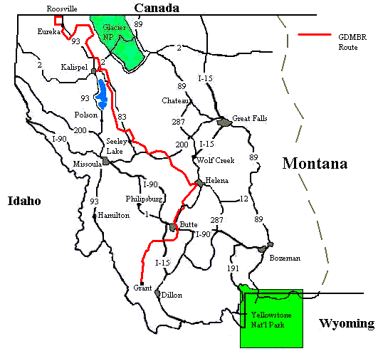
Great Divide Bicycle Route 2000 (Section 1) |
![]()
![]()
![]()
![]()
|
|
GREAT DIVIDE BIKE ROUTE SECTION 1 Eureka, MT to Grant, MT July 9 to Aug. 1, 2000 31,012 miles (50,019 km) cumulative
Teasers:
"What a noble gift to man are the forests! What a debt of gratitude and admiration we owe for their utility and their beauty!" View PhotosGDMBR Day 1 - To Eureka We stand with our heels on the US/Canada border, our front wheels facing south. To the left extends lush green pine forest up into the rounded hills. To the right is more of the same. Sweeping down from the mountains is a perfectly straight gap in the trees. It descends from the left hills, extends across the fertile valley, and climbs the hills to the right. As per the border treaty between the US and Canada the boundary is to be marked and visible at all times. Which means that a crew must go out each year to hand cut this straight line in the trees. We roll on up to the little white kiosk where the heavy set border guard recited the usual questions, "You're citizens of where?". "USA", replies Brian. "You were born where?" "Fitchburg, Mass." "Are you bringing anything back, alcohol, firearms, tobacco?" "Nope", Brian finishes. I finally roll up, after having taking a quick photo. "You also a US citizen?" the guard asks. "Yup", I reply. Finally I get to ask a question. "Do you get a lot of people who say they're riding to Mexico on a dirt road?" I query. "Lots of people." he replies with a shrug. This was it, the day we'd been anticipating. Our first pedal push on the Great Divide Mountain Bike Route was about to happen. We eagerly anticipated mile upon mile of isolated, quiet dirt roads. We pictured steep climbs into alpine meadows where only a few jeep drivers dared tread, skinny trails cutting across high mountain ridges, and solitary rides along banks of clear cool streams. No more trucks, no more huge RVs, no more tour buses. Immediately after the border crossing we made our very first route direction change, a right turn onto Airport road, and rolled gently onto ... pavement? That's right. Of the 2476 miles of the complete trail length about 10%, or 248, miles are paved. It just so happens the first 30 miles is paved. It wasn't until the next day, after leaving Eureka, that we actually hit our first dirt. Our eager anticipation would have to wait another day Adventure Cycling Associations Great Divide Mountain Bike Route (GDMBR) was designed to roughly follow the continental divide within the US lower 48 states using as much dirt road and trail as possible. The Continental Divide is not just an imaginary line drawn on a map. It is a true physical barrier that divides both the North and South American continents into two parts. It defines the direction of water flow throughout the entire landmass. Rain falling on east side flows to the Atlantic Ocean and rain falling on the west ends up in the Pacific. Some rain falling in the northern regions of Canada ends up in the Arctic Ocean as well. The divide is located within the high spine of the Rocky Mountains in North America and the Andes in South America. Within the lower 48 states of the US the divide winds through the 5 states of Montana, Idaho, Wyoming, Colorado, and New Mexico. It's not a straight line by any means. It wiggles and waggles back and forth, sometimes backtracking on itself, following the natural contour of the mountains. Mother Nature ignores all human tendency for straight lines and even borders. At the US/Canada border the Continental Divide enters Montana high in the ridges of Glacier National Park mountains. It snakes in a general southeasterly direction passing to the west of the city of Helena. It wraps itself around the southeastern side of Butte as it head north, west, and then south again toward Idaho. It hits Idaho right at the point where route 93 passes the state line from Idaho into Montana. From here the state line follows the Continental divide back to the east toward Yellowstone National Park. Our route entered the US about 40 miles to the west of the true divide at the town of Roosville. For the first 200 miles or so we would be winding our way through the mountains to the west of the divide. It wouldn't be until we approached Helena that we would make our first divide crossing, an event that will happen 27 times along this route. For our first night on the trail we stayed in the riverside park in Eureka, MT at no cost. It had been been a beautiful first GDMBR day. The wind was light, the sun was shining, it was warm for a change, and the terrain had been fairly level. We even had free entertainment at our campsite. Just across the small creek in a small outdoor museum called the Historic Village, a group was having something called a Chick'n Pick'n Fest. We couldn't make out the words, but the music was definitely of a bluegrass, country ilk complete with banjos, guitars, and cowboy hats. As we set up our tent Brian raised his arms into the air, turns around slowly as if praising the heavens, and exclaims, "The weather's great, summer's here, we're on the trail, we have free camping and free entertainment, what more could you ask for." "Free food.", I piped in. "Yeah right. Where're you gonna get that.", he retorts. We finished setting up camp, which consists of erecting the tent, inflating the Thermarest mattresses, laying out the sleeping bags and sheets, unloading the bags from the bikes and tossing them in the tent, then locking the bikes to the table. The whole process taking a good 1/2 hour. Afterwards we hightailed it over to the Town Pump gas station to empty our ready to explode bladders. Why not go take a look at the song fest and Historic Village. We've got time. Crossing the street we passed under the banner that announced Chick'n Pick'n fest, Free! Free music we had already gathered. To our left stood a long stage-on-wheels packed with those cowboy hat toting musicians who were just belting away on one of their country style songs. Another, much smaller stage, lay a bit further on. It looked set up and ready for another, albeit much smaller, band of some sort. In front of the stage were several rows of chairs rather sparsely populated and several picnic tables lined up in a row. People sat at the tables chowing down on some mighty finger lickin good looking chicken, the chick'n part of the fest. To the right were several concession style stalls, one for pop (soda for us easterners), one for books, and another where that good looking chicken was clearly coming from. To the rear, a huge barbecue covered with good smelling chicken carcasses. As we approached, probably looking more hungry than curious, one man came up and handed us a bunch of cards bearing a black and white sketch of a very familiar visage, Jesus Christ or rather the typical western European vision of Christ. So this was some sort of religious rally. Not being all that interested, we were just about to veer away when another woman approached. She had an intense look of excitement in her eyes. "Oh no," I thought, "Here comes the religion lesson." "Would you like some chicken?" she asked, "It's free." Brian and I looked at each other a bit shocked. There was chicken, beans, cold slaw, potato chips, rolls, and pop all at absolutely no charge. The only price was you had to sit and listen to some C&W gospel music for a while. Hey, what the heck. The singers were pretty good even if the entire expanse of the subject seems to be "Praise the Lord" and that's about it. Needless to say several helpings of dinner hit our plates that evening. What does it say in the Bible? "Ask and thou shalt receive." Sometimes that just does work. GDMBR Day 2 - To Tuchuck From Eureka we paralleled Rt 93 just to the west along yet another set of paved roads. We crossed Rt 93 at about the nonexistent town of Fortine and started heading up into the mountains. Finally, after about another 6 miles of pavement we hit our first dirt. Yeah, say good bye to traffic, or so we thought. It was the Sunday afternoon following a nice weekend with some of the first summer like weather. Half of the state of Montana must have decided to take to the hills and it seemed they were all on this dirt road hurrying to get home. We ate dirt for several hours as we huffed and puffed up the steep dirt grade. We took a right on to a road marked with a huge sign saying, "Road closed. Culvert out 3 mi. ahead." "Yeah, no more cars." we thought. Yet there just had to be one last straggler, someone who just had to venture down the closed road to see for themselves that the culvert was, in fact, gone. From the turn we had another 2 miles and a good 800 ft of hot, steep climbing to get to what is called the Montana Divide. I suppose it's sort of a Montana version of the Continental Divide. Another 1 mile and we found the missing culvert. Not just a little, missing culvert. No. It was a good 8 ft deep chasm cut right across the road. Our only alternative, take everything off the bikes, carry it all across, and put it all back on. We were definitely getting our exercise quota for the day. From here to our first campsite, Tuchuck, we were on what is described as a "glorious descent through wild country" on our maps. They just didn't happen to mention the several good sized bumps all along the way. Tuchuck should not have been a particularly noteworthy campground. There was no good mountain or lakeside views and the surrounding lodgpole pine trees appeared to be suffering from some sort of insect infestation as they were mostly dying. The needles were all a rust color and many of the branches were already dead. We gave up trying to find a tree for hanging our food and decided to store it in a latrine in the nearby horse camp. It happened to have an outer lock and to be a concrete block building. Seemed to us it'd be about as safe as any hardsided vehicle. We renamed the campground to Tubob. That's because we found 2 forgotten flags from B.O.B. bike trailers. They are now stuck in the ground at the entrance to our renamed TuB.O.B. campground.Camp was quickly set up and our little tarp strung between two trees. We then sat ourselves under the tarp and waited for the oncoming storm to hit. For the previous half hour we'd watched the southward blue sky cloud over with white puffies and then dark meanies. Lightning flashed, thunder roared, the wind started to howl, and then the rain began. It started slowly, then crashed down with a fury. Not just rain, but hail. Marble sized hail poured down from the sky rapidly covering the ground with little white balls. We cowered underneath our little tarp trying to keep dry, trying to keep from getting beaned, and keeping an uneasy eye on the tent. If it gave way we'd have one cold, wet night. In all we had three bouts of rain/hail with short periods of clear between which just barely gave us enough time to cook dinner and clean up. We came to one conclusion after this night, we needed a bigger tarp. We're really regretting leaving our nice 9X14 nylon tarp back in the camper. So that should be it for our Tuchuck, I mean Tubob, campground experience. Not quite. It was 5 AM, still dark even in these northern July times. Something had woken me up and it was not my usual need to find a nearby bush. I listened for the silence, which was not so silent. There was a loud munching noise, the sound a large jersey cow makes as it dumbly gnaws on straw. "Deer", I figured. Our mystery animal then started a thumping noise, pawing the ground I guess, which finally got Brian up. "What's that?" he whispered. "Don't know", I replied. Boing, was the next noise. Brian was up like a shot to check it out. I bravely buried my head back in my sleeping bag. if it turned out to be a bear it'd get Brian first. Into the cold, black night air Brian crept forward shining our little flashlight in the general direction of the once again munching noise. It was an elk. It stood there, in mid munch, and stared at Brian with a look that said, "Hey. What do you want? Can't you see I'm busy?" Draped from its mouth, now covered in saliva, was the little pink washcloth we had used to wipe off our sweat and then hung on the line to dry. The 'boing' sound was not the elk tripping over the line. It was the sound of the cloth being snatched off the line. From the tent I hear "Hey" and the "Get outta here" as Brian shooed the elk away. Fortunately it left the washcloth behind which Brian hung back on the line. Brian back in the tent, we both tried to settle down for at least a couple more hours sleep. Minutes later we heard that now recognizable 'boing'. "Your turn." Brian mumbles. This time I'd fix it. Once I had on my clothes and shoes and was out of the tent I found not a trace of the elk, but the washcloth was once again lying on the ground. Gingerly holding the slimy thing between thumb and forefinger, I walked over to the latrine and hung it inside the door. Just see it get that. So now we can get back to sleep. A few minutes later we once again hear the stomp, stomp, stomp and another boing, this time it really did trip. Brian sighs, "Do you think we can scare it." Once again he gets up, shins the light toward our intruder, and all I here is "It's eating my seat." It was standing there just licking away on the seat of Brian's bike. Mine was covered in a plastic bag. That was the last straw. Whether we wanted to be or not, we were up at a bright and early 6 AM. GDMBR Day 3 - To Red Meadow Lake Cachunk, ching, tuk, tuk, tuk, tuk. Brian came to a sliding halt. He turned and yelled back to me, "That didn't sound good." I'd already come to my own fast, sliding halt and was starting to investigate this strange noise. "I know" I yelled. We'd just turned back onto the road out of Tuchuck(Tubob) campground and were continuing that 'glorious descent' when something went awry with my bike. It took only minutes to discover that the lower hook on one of my homemade front drybag panniers had come loose and wrapped itself around the hub of my wheel. How to get it off? The former hook now made a complete 360 degree loop. Without removing the bags, we managed to slip the front wheel off, pull this new ring off, and get the wheel back in place. Now we had to figure out how to remount my bag. Out of our bag of spare odds and ends came a bungee cord. A wrap and snap into place and the bag looked sufficiently secure to make it to Kalispel, we hoped. It was becoming evident that we would need to do a bit of maintenance and repair work during a day off in the city. With raging hail storms, washcloth sucking elk, and one fairly significant equipment failure our stay at Tuchuck will always remain in our memory. After leaving Tuchuck the route took us to the northeast to within 6 miles of the Canadian border along the back dirt road that leads north out of the town of Polebridge. Oddly we noted how much better and smoother the road up to Tuchuck was, the road less traveled, than the busier road south into Polebridge. The more traffic, the worse the road for biker, more dust, more washboard, more loose rocks, more potholes. Rather than turn left toward Canada, we turned right toward the south. Following the road to within 5 miles of Polebridge, we skirted right along the western edge of the US's Glacier National Park. Then we turned westward once again to begin another long climb up to Red Meadow pass. As with most mountain pass roads we've ever encountered the road starts with a gradual, easy climb and then just within 2 to 3 miles of the top it steepens to a good 10% or more grade. This is hard enough with a loaded bike on a paved surface. It's doubly hard on dirt. Traction is compromised and the rear wheel keeps slipping backwards. Half a slip back for every 2 turns forward it seems. To keep on moving, getting legs that were already worn out from the previous day's ride turning, I concentrated on the scenery unfolding around me. From the roadway we caught glimpses of those wonderful jagged peaks of the glacial carved mountains within Glacier National park. While Canada may have scores of spectacular, glacier carved mountains, the US has only a few locations with such wonders. It's easy to see why Glacier National Park came into being so long ago. Today, however, Glacier is suffering the same epidemic so many of the US's world famous parks are, being loved to death. It has become literally overwhelmed with the millions of visitors who descend upon it each year. Going-to-the-Sun highway, considered to be the highlight of a visit to the park, is woefully overused and in desperate need of repairs. Yet attempts by the Park Service to close it for a year for renovations met with failure. The Indians on the east side of the park, who happen to run the concession lodge and restaurant, would lose lots of money. Length and width restrictions imposed upon all vehicles driving the highway have done little to alleviate the traffic. To park at the top of Logan Pass to take a hike you'd better be up there by 7 AM or else forget finding a spot. It's becoming clear that Glacier will probably have to go the same route as Yosemite, block that road to all vehicles except concession run vans and buses. We hope bikes will still be permitted. Yet there are still remote areas of the park where few visitors go. The west side, near Polebridge, for instance. There are no main roads in this area. Access requires a lot of leg work, hiking and backpacking. Consequently this region is far less visited. Dan, whom we found making a halfhearted attempt at fly fishing up at Red Meadow Lake, told us "I have a friend who owns a B&B in Whitefish. One day this man, who was staying at the B&B, came in and announced, 'I saw the park today.' My friend thinks about it and replies, 'There are thousands and thousands of acres in that park. What do you mean you've seen the park?' 'Well I drove the Going-to-the-Sun Highway.' the man replied. My friend was appalled." I guess I'm not. As long as the majority of people believe you can see an entire National Park the size of Glacier, Yellowstone, Grand Tetons, or Yosemite just from the seat of their pants then there'll still be quiet, remote places left for the rest of us. We climbed up as far as Red Meadow Lake, saw that there was a new latrine and tableless picnic tables, and noted the gorgeous, alpine lake. Winds were blowing hard from the west keeping the mosquitos away. Our other option was to ride down to Upper Whitefish lake which, being downhill almost all the way, would make the next day's ride significantly shorter. Well, Dan convinced us that while Red Meadow may not have tables to accompany the benches, it looked as if the table tops were being replaced, it did have the advantage of being more open and windier which keeps the bugs away. He didn't think Upper Whitefish had table or toilets and, being more enclosed, would be buggier. The result of the entire conversation was that he convinced us to stay, a decision which would prove to be a huge mistake. Fortunately he made up for his questionable advice by offering a couple of ice cold Bud lights. What a night. As the sun went down, that blessed wind that had done such a good job keeping the bugs away started to abate. Millions of mosquitos that had been hatched that day and were just waiting for an easy, warm blooded target descended upon us. They swarmed. Stop swatting long enough get bread out of the wrapper and you'd be bitten on the forehead. Open your mouth, they'd fly right in. We moved between tableless picnic benches searching for some spot where we could make dinner in peace, all to no avail. We gave up on the idea of cooking anything and proceeded to eat whatever we had left in its out-of-the-wrapper cold condition. Three day old stale bread topped with dry tuna, crushed crackers, and gorp (good ole raisins and peanuts) was all we had left. Not exactly a calorie filled meal to top off a tough riding day. We secured the food, once again taking advantage of the nearby latrine, dove into the tent, and spent the next 1/2 hour swatting mosquitos in the tent. I've renamed Red Meadow Lake to Red Mosquito Lake. They're red because they're so engorged with our blood. GDMBR Day 4 - To Kalispel The minute the sun came up, we got up. It was a race. Could we get packed up and out of there before the mosquitos got up. Hurridly, we stuffed, folded, zipped, strapped everything together and onto the bikes. It took maybe 1/2 hour, yet the bugs still managed to get in a few last nibbles before we were ready. Breakfast would come later. It a brisk 40 degrees F and, after we finished the short climb to the pass, our downhill glide remained in the shadow of the surrounding mountains. My fingers felt like icicles. Steering a loaded mountain bike through loose rock and around potholes with numb hands is not an easy task. Each 1/2 mile we'd stop to shove the fingers in our pockets or blow on cupped hands just to keep some feeling in the tips. It took about 1/2 hour for us to find a small meadow opening out in the sun. We pulled over to eat what little we had for breakfast; dried fruit and granola bars. Suddenly from the bushes came a strange 'huff huff woosh' sound. Something big was breathing heavily in the trees. There was no debating as we quickly decided it was time to get moving again. Ironically when we got to Upper Whitefish Lake we discovered that not only did this 'informal' camping site have both picnic tables and a latrine, it also had great food hanging trees and no bugs. If only we'd followed our first inclination and continued on the night before. If the route from Tuchuck was considered to be a "glorious descent", then I don't know what to call the descent from Red Meadow. Now that was a definite long and glorious descent on roads that were in remarkably good condition. Easily we coasted along at speeds approaching those we'd expect on well paved road. It was an easy ride down to the very yuppie town of Whitefish where a lot of former Californians have moved in and built luxury houses along the lakeshore. We stopped to eat some real food at a local cafe. Then we had a relatively flat ride along back roads that, thankfully, avoided the dreaded Rt. 2 to the town of Columbia Falls. Columbia Falls seems to be where the worker people live. We stopped at a store for some ice cream. Now you know you're really bike touring when you can walk into a store, buy a 6 pack of ice cream sandwiches, down all 6 without thinking twice, and still not gain weight. Brian had 4, I got the other 2. We then had another choice. We could stop in Columbia Falls and then ride the remaining 17 miles to Kalispel the next day before taking a rest day or ride on to Kalispel right then. We went on. But, by the time we finally pulled into the campground we'd had enough. Time for rest, maintenance, and repair. GDMBR Day 5 - To Big Fork After our day off we returned to the trail via the exact same route by which we'd left. We've decided we will try to ride every inch of the GDMBR which means returning to the spot where we leave it every time. From there to Big Fork was a reasonably easy ride over mostly paved roads that wound through gently rolling valley farm country. We did have only one small bit of trouble finding the route. The directions said something like, "At the T turn left then in .02 miles turn right on Van Sant road." As it turns out there are 2 rights before Van Sant. The first is a dead end road, some ATV riding boys told us that. The second goes into a housing area. When we told a man we were looking for Van Sant he said, "I knew that." I guess we're not the first to make that mistake. Finally, on the third try we got it right. We rode into Big Fork, plopped ourselves down in the Wayfarers state park, and decided to take one more day off. We still had errands to do before heading into the wilds and the swimming was refreshing. GDMBR Day 6 - To Cedar Creek Back to tough riding. After far too many miles of pavement we returned to dirt just west of the miniscule town of Ferndale, east of Big Fork. Looking at the elevation profile on our map I gasped, "We're supposed to go up that? It's nearly vertical." I don't care what kind road surface it is, I do not do vertical. We turned onto the dirt road and started a long, gradual climb. For a dirt road, the road surface was great. In some cases it seemed to be almost like a paved road. We climbed, climbed, and climbed amid tall pine trees and occasional clear cut areas all the while anxiously waiting for that dreaded vertical section. It just did not happen. Yeah there were some steep parts to the climb, but nothing nearly as steep as those last few miles up to the first 2 passes early on in the trail. Could we be in better shape? Were we just better rested? We have no explanation other than the map is exaggerated. We are starting to learn that the map tends to over or under emphasize different aspects of the route. You just have to ride on through and see what happens. After the 2000 ft climb we had another nice long downhill and then a series of gentle rollers along the west side of Swan River. For the most part it was a ride through dense forest. Only in the clear-cut areas could we get views of the magnificent surrounding mountains. Having completed about 30 miles it was time to start looking for a campsite. We're not very particular about where we camp. The site needs only meet a few requirements. It needs a flat spot for the tent, preferably away from the road and not overly rocky. There needs to be water nearby, we prefer streams to lakes as they have fewer mosquitos. There needs to be a tree for hanging food. The ideal tree would have that one strong perfectly horizontal branch about 15 ft off the ground and about 8 ft long. But, we've concluded that the perfect tree doesn't exist or is so rare that we've never seen one. So we take any tree that has any branch strong enough to hold the food. Even a downed tree leaning against another at an angle would do. Well, we rode on and on and on. There'd be a place for the tent, but no tree or water, a flowing stream with some respectable trees, but no tent spot, or water and a tent spot but a clear cut area with 3 ft. tall treelets. Our 30 miles soon turned into 32, 35, 38 and then 43 miles. We ended up climbing an extra 500 ft and riding an extra 8 miles before we finally just took whatever spot we could find. A small pull-out next to the road just .1 mile from a stream. The tree wasn't great, just enough to get the food off the ground, but would have to do. Thank goodness it was a rarely used road as had a car passed while we ate or slept we would have been covered in dust. So far we haven't exactly had the best of luck in getting good campsites. GDMBR Day 7 - To Holland Lake Today we would ride our first few miles of single track, fortunately easy single track. In fact, the entire day was just an easy ride over pretty good road surfaces up and down gently rolling hills along the west side of the Swan River. That suited us just fine as we were both feeling quite tired after the previous day's extra mileage. About the only odd encounter was the huge group of young women mountain bikers we encountered. Here they were, about 20 or more, clustered together in an open field next to the first single track section. Identical bikes were neatly lined up in a row, the women all wore identical day packs, and they were eating the same food for lunch. Must be some sort of high school summer camp. What a camp. Imagine being able to spend your summer camp mountain biking around Montana. Not bad. We got as far as the Holland Lake picnic area where we both immediately decided our legs were not up to doing another 1000 ft climb up to Clearwater Lake. But, the cost of the Holland Lake campground, one of those expensive concession run places, seemed a bit steep. $10 for nothing but a vault toilet, water, and a table is rather high. We had contrived to eat in the picnic area and then move down the road to pitch the tent for the night. We got lucky. The concessionaire employee noticed that we looked pooped and he knew we were on the GDMBR. He invited us to stay in the group campsite for the night, no fee. We'd just have to put up with a late arriving Boy Scout Group. It was an invitation we couldn't refuse. GDMBR Day 8 - To Seeley Lake "Oh no!", I cried, "I forgot my hat." We were 2.34 miles away from and a good 500 ft higher that Holland Lake and I'd just discovered my missing hat. It's not just any ordinary hat. It's an Australian made IBF Aussie Sports Hat, plush light tan leather, wide brim, fancy braid around the cap. It's perfect for both cold and warm weather. It's a hat that's so nice and fits so well that I've actually had several perfect strangers comment, "Nice hat" right out of the blue. Normally such a hat would cost somewhere around $80. But, Brian found this little gem in a Phoenix thrift store where it was tagged at $3.00. Since they were having a sale that day, the cashier rang it up at a whopping $2.10. Needless to say it'd be an extremely expensive hat to replace. I had to go back. I unloaded the bike, road as fast and hard as I could back to Holland lake, found the hat sitting on the bench right where I left it, and then road as fast and hard as I could back to where Brian was waiting. The day had not started out well and I knew with an extra 5 miles and 500 ft climb I would be mighty pooped by the time we reached Seeley Lake. But, I had my hat back. Riding between Holland Lake and Seeley Lake is the most interesting and frightening section we'd experienced to date. The route starts out mundane enough, a reasonable dirt road with a steady climb having occasional steep sections lasting no more than 1/4 mile at most. Then we get to a trail, our second single track part, that is marked as being "grassed in" on the map. "Grassed in" is quite an understatement. We're talking about a narrow path through knee and sometimes helmet high yellow flowers. Our legs and bags brushed through the flowers as we carefully threaded our way along the path. It was actually rather fun. How often does one get to ride a bike through a field of wild flowers. When we came to the short, super steep hill after only about 4 miles we knew the wildflower ride had come to an end. Too bad. We'd almost like to do it again. Further on, however, came a section we're not sure we'd say the same about. The total climb up to a path known as Richmond Ridge was about 3000 ft. So by the time we got to the next single track section right at the top we were already feeling the tiredness in our legs. The map directions said something about the road becoming more primitive, be careful about washed out sections, and there would be occasional downed trees in the way. In no way did it prepare us for the difficult trail ahead. It used to be a road. In fact, one ranger we spoke to in Seeley Lake told us that as late as 1980 it was still drivable. Today there are spots where the entire road has washed away or is covered in a rock slide. The path you're supposed to take a heavily loaded bike on dips down on the steep side of the mountain to get around the impasses. It took both of us working on one bike to get around. Further on we found much of the old road quickly becoming overgrown. The path threaded its way between 7 or 8 foot tall pine trees. We had to shove aside the branches to get through. The final and most frightening aspect was all the fresh, very very fresh, bear scat along the way. This is scat that still has a wet sheen indicating it's probably less than 24 hours old. Big piles of scat were intermittently located along the old road bed. Nervously we rang the bell more often and yelled a lot louder. For the approximately 5 miles we were on this trail we had to negotiate rock slides and fallen trees, precariously ride between overgrown trees, try not to run off the side of the mountain or into one of those trees, watch all the overgrown bushes looking for bears, yell, ring the bell, and maybe, just maybe, get to look at the spectacular scenery all around. Relief is the only word to describe how we felt when we finally returned to a more normal, forest road. We're just hoping the remaining single track sections are either easier to ride or not in such prolific bear country. With that long 3500 ft climb and some difficult single track behind us we relished the long coast into Seeley Lake and immediately decided to take another rest day. It is becoming evident that 3 days of riding between rest days is about all we can do through this mountainous section of the GDMBR GDMBR - Day 9 - Past Ovando You know you've really been doing some serious hill biking when you can look at day with a 1200 ft elevation gain and think, "That's not so bad." And it really wasn't so bad. The road was pretty good, for a dirt road that is, we only met a few cars including our first log truck in the wilderness, and we even managed to get to Ovando, some 30 miles, in time for lunch. The only real obstacle was the muddy 10 miles after the fire base camp. Severe thunderstorms the previous Thursday night had ignited several fires in the back country. The Forest Service sprang into action and organized a 300 plus fire fighting crew. They were based at a place called the Monture work camp which happened to be right on our route. They had quite a little instant city. There were buses for transporting the crew, large tents for the kitchen, dining, and wash facilities, trucks for hauling everything needed to feed and house the group, and a gaggle of little nylon tents scattered through the trees, homes for individual crew members. All was fairly quiet when we went by, they were out on the fire line during the day. But I imagine during the evening and morning hours it's a hustling, bustling place. There's not much in Ovando, a tiny general store that at this time had been nearly wiped clean by the fire crew, an angler's store, an espresso shop, a brand bar museum, and Trixies saloon and fine dining. Trixies must be an institution as it's the only bar marked on the biking maps. It has its very own symbol of a frosty beer mug. The woman at the general store told us that most bikers head there for some fat intake. Instead we headed for the freezer section and a half gallon of a gooey, sweet ice cream called Denali Moose Tracks. It's vanilla ice cream with tiny peanut butter cups and a good lacing of chocolate fudge. Upon paying for it Brian asks the woman, "You wouldn't happen to have any plastic spoons?" Incredulously she stared at us, "You're going to eat it here?" "Sure" we replied. Later, as Brian took the now empty box over to trash bin she asked, "How'd we do?" "We ate it.", Brian replied. I think this is the thing I like best about bike touring, we can eat just about anything we want and not worry about the calories. Although it was good that we only had another 10 miles across flat, washboard ranch roads to go for the evening as I don't think I could have done any more climbing on such a full tummy GDMBR Day 10 - To Lincoln, MT "You on that bike ride? The one that goes from pass to pass?" the man in the truck asked. "You on the Great Divide route?", another couple men in another truck asked a few days later. Usually when on a bike tour in the US people seemed surprised to see us with our fully loaded bikes and they have no idea what we could possibly be doing, where we are going, or where we started. But, not on this route and not through this section of Montana. It seems this mountain bike route has gained a bit of fame. All along the way people know about it, store owners, campground employees, even people we meet out in the back woods. It must have been quite a surprise for these people when, three years ago, they started seeing these bikers going by way out in the middle of nowhere, their bikes all covered with bags or towing a loaded B.O.B. trailer. One biker or two they could have dismissed as some crazy biker gone astray. But when the occasional bike tourist turned into a steady stream I'm sure they quickly investigated what was going on. Montana has played host to road tourists for years. Now they're getting used to the off-road tourist as well and from what we've seen they seem to be quite amused by what they probably consider to be total insanity. They're nice enough, generally. We even had one woman apologize for kicking up dust as she drove by in her minivan. Wow. We haven't had that happen before. "The hill of the day", that's what we're starting to call them. It seems each and every day on this route there's at least one climb over 1000 ft. For this day it was to be a mere 1600 ft climb up through the mountains just to the north of Rt 200 between the towns of Ovando and Lincoln. The previous night we'd ridden just to the edge of the climb, literally to the edge. Within 100 yards the road snaked around 180 degrees to begin the first steep section. From there the road zigzagged up the side of the hill affording fantastic views of the valley containing Hwy 200. Then it curved around the backside of the mountains to climb through the pass, a pass those highway drivers never get to see. We enjoyed wonderful scenery all the way up and again all the way down. Even the road for this short 22 mile stretch was in good condition. We arrived early in the town of Lincoln and, taking the advice of a friend who'd ridden this section 2 years previously, we headed for the town park, set up camp, and took the rest of the afternoon off. At least Brian took a rest. I changed into my swim suit and took an ice cold shower under the nearby faucet. Lincoln is one of those old mining supply towns that managed to survive by transforming into a highway service town. Like so many other highway service towns, it is basically spread out along the length of the road for about a mile or two. There are several hotels, a couple of gas stations, restaurants and cafes, some Montana tourist trinket shops, as well as a couple of tiny grocery stores. It's place one stops while going elsewhere. Not a destination. Perhaps the one building of remarkable interest is the old Lincoln lodge. It's an old log cabin style hotel that has been in business since the late 1800s as evidenced by the first page of the hotel register proudly displayed above the bar. The outside today is stained in a bright maroon red color and its facade actually looks fairly simple. Inside, however, the bar and restaurant look to be quite elegant by western road service standards. During the old days of stage coaches it was probably the one and only establishment in town catering to the traveler's needs. Today it's not alone. GDMBR Day 11 - To Lost Horse Creek crossing What would the world be, once bereft Taken individually these "hills of the day" are not that difficult. It's just that when you've done these sorts of climbs day after day, you become completely drained. Three days of riding with a day of rest we can handle. Try for anything longer and we get too pooped. Yet here we were trying for a 4 day stint to Helena and from what we'd heard this day would prove to be the most difficult we'd encountered thus far. Our friend, Bob Immler, commented that at mile 317 he encountered a 4 mile long hill most of which he pushed his bike. We'd been looking toward this section with both trepidation and disbelief. "Perhaps he didn't have good gearing," we hoped. This is one section where the maps call the main route "extremely steep" and then actually provide an alternate route that was supposed to be "slightly" easier, but about twice as long. Our question was, just how much easier does the word "slightly" really mean. We stopped in at the ranger station to find out. The woman behind the desk commented, "I've only been up that road twice, both times in a truck. Even then it seemed steep and I don't think one road is any better than the other. That's steep country back there." So our choice appeared to be extremely steep and 4 miles long or extremely steep and 8 miles long. We went for the 4 mile choice. Turning onto that section the road does suddenly steepen for about 1/4 mile but it's still rideable. In fact, the first 3 miles are actually rather easy. The road is a smooth dirt jeep track running through the woods with trees tall enough to afford plenty of shade. Three stream crossings and some abandoned cabins along the way add lots of interest. We kept thinking, "This isn't so bad. Bob must be a whimp." Then we hit mile 3. Oh my god, the road seemed to go straight up or at least it was probably more than a 20% grade. It didn't just go at this angle for a bit, it kept going and going and going. For 1.4 miles we climbed, actually we pushed. There was no way we could pedal up such an incline on a loose rock road carrying all that weight on our bikes. Even pushing it was tough. We'd shove for about 1/4 mile, stop for a rest, and then shove for another 1/4 where we'd take another rest. Out on the exposed side of the mountain, the sun beating down, we gradually crept straight up the side of that mountain. It took us over an hour to climb up this one 1.4 mile section and it took every ounce of strength we had to keep pushing on. We are now wondering whether the alternate route might have been the better choice. Oh yeah and Bob is not a whimp. Gasping for air as we finally pushed the bikes back onto the main road we looked upon the slight downhill with dismay. According to our interpretation of the maps we still had a good 500 ft to climb. Any downhill meant we'd be climbing right back up. There was no way we could do any extra up. Yet the flat or downhill continued. It went on to the point of our very first Continental Divide crossing where the long steep downhill began almost immediately. We found ourselves in a high mountain meadow surrounded by green grass, wild flowers, and mountain top views all around. Well, we do have to admit, the map planners sure picked a first divide crossing that will stand out in people's memories both for its difficulty and its beauty From the top it's a long, steep ride down to the east side valley. We passed one nice campsite thinking there'd be more along the way. But there weren't. This is the dry side of the mountains, the place where trees and shade are scarce and ranchers have fenced off large tracks of land for their cattle. We were passing back and forth between private land and National Forest and for this long hot stretch in the valley bottom we encountered mile after mile of shadeless fields surrounded by barbed wire. We turned back toward the next climb, the next ascent of the Continental Divide. Water was hard to find as well as flat shaded, fenceless tent sites. We finally found the one stream crossing we'd seen for 10 miles, the small trickle called Lost Horse. Yet it was surrounded by private land, the wreck of a cabin and a trailer attested to that. But we had to stop. Fortunately the owners never showed up. I wonder what they would have said, finding 2 tired bikers camped on the side of the road right next to their ruined trailer. Thank goodness we'll never know. GDMBR Day 12 - To Helena It was our fourth day since a rest, our fourth straight day of long climbs. We were tired enough when we got up, but that would be only a taste of how tired we'd be at the end of the day. According to the map we should have had just a 1000 ft climb to our second divide crossing, another little 500 ft climb to something called a drainage divide, and then one itty, bitty 200 ft climb up to Priest pass after which we'd have a long 15 mile downhill into the big city. The first two climbs lived up to expectations, with the exception that we'd continued climbing a good 200 ft or so before realizing that we'd gone beyond the turn at the second divide crossing. The last thing we needed was to make such a mistake and add extra vertical feet to our daily total. But, the third climb for the day, the one up to Priest Pass, the one to our third divide crossing was in no way a mere 200 ft. Not a chance. For all of the 2.4 miles we climbed non stop at a speed that would indicate a 6 to 7% grade. That easily converts to a good 600 to 700 ft, minimum. Clearly the map is way underestimating the elevation change here. In addition to the extra, unanticipated climbing, we were finding absolutely no water. It's a drought year in much of the west and many of the streams marked on the map are dry as a bone. Brian cursed the map, the map makers, and the map makers parents all the way to the top where we proceeded to drain off the last drops of precious liquid we had left. We needed to find water, fast, or we'd be in big trouble. Along came help in the form of a big truck marked Fire Department on the side. Certainly one would expect a fire department truck to carry water and they did. Three 16 oz bottles of spring water, just enough to get us down the hill and into Helena. Actually it wasn't quite enough. Just a bit further on we found a slender trickle of a water, just barely enough to get the intake hose of the water filter into. We filled those 16 oz bottle for a second round and that was just enough. We endured the heat of the black asphalt of Rt 12 and the hot, extremely dry headwind for the last 7 miles into Helena where we promptly found a grocery store, down cans of soda and 32 oz bottle of sport drink. We'd stay in Helena for at least one day to get that 4th day of rest that we need. A lesson learned, we need to start carrying more water and add some sport drink crystals. No longer can we take for granted that there will be a running stream where marked on the map. Before we made that last, thirsty climb over Priest Pass we did take the opportunity to explore some old mine ruins around an area called Dog Creek. Judging by the area covered and the size of some of the building remains it was a huge underground mining operation. The ground is obvious piles of slag heaps for acres. There are old mine ponds, wooden structures over old mine shafts, 4 huge sunken metal boxes that formed what must have been some sort of settling pond, as well as the back wall of the sorting or milling building. A great place to explore, but we'd bet an environmental disaster. We had to wonder what kind of chemicals remain in the ground and leach up through the water into those ponds. Mercury perhaps? There is a beaver living in one of the ponds, its beaver lodge located on the south edge. So maybe it's not so bad, but I doubt it. That mine came long before the days of environmental activism and I'd bet their disposal practices were abysmal by today's standards. GDMBR Day 13 - To Park Lake In June of 1864 a couple of prospectors camped beside a small creek for the night. Like most prospectors of that time their endeavors further west had been unsuccessful and they were on their way back home. They decided to take one last chance at striking the big one and, as some of those old mining stories work out, they did find their bonanza. Within a year the narrow gulch, by then known as Last Chance Gulch. was lined with placer mines and little log miner's cabins. Over the years they managed to extract some $3 million in gold from the stream bed. Unlike so many boom towns, Last Chance managed to continue on even after the major boom was over. The residents found there was even more profits to be made by providing supplies to their neighbors. One of their biggest exports was lime found in abundance on the south end of the gulch. So while the residents continued to mine their claims in their back yards, they also were gainfully employed in other businesses. Eventually Last Chance managed to wrest the honor of state capitol from another mining boom town, Virginia City, in 1875 and the name was changed to Helena. You can still see some of the old mining buildings in Last Chance Gulch just south of the city. There's even a small mining operation continuing today, at least when there's water in the creek. They say that after a good gully washer you may be able to find a nugget in the gutter. One set of old brick buildings just on the edge of Last Chance has been carefully restored to it original 1864 appearance. A real estate agent named Reeder came to Last Chance with the intention of plying his trade. Obtaining a small lot of land, he built a set of brick row houses even incorporating an existing log cabin into the design. The little rooms were then rented out to the bachelor miners for whom the use of a nice brick room as opposed to a dirty log cabin was quite appealing. Even before Reeder's death the set of row houses and the adjoining street were known as Reeder's Alley. After the miners left the little bachelors quarters continued to be rented out. However, neglect eventually caused the buildings to become run down and a more seedy side of Helena moved in. It was the red light district. But, to the rescue came a couple of matrons who in 1929 decided to rebuild one of the original stone houses. They turned it into a restaurant. Soon refurbishment abounded in the little alley. Today the original log and brick houses contain a museum, restaurants, and a few shops. The bike route is supposed to pass right through Reeder's Alley. But, having missed a turn somewhere in downtown Helena, we wound up on the wrong end. So we explored its length on foot. It's not very big and I wouldn't say that it's an overly busy place. But it is a quaint reminder of Helena's early years. Ah, the climb of the day. Actually make that two climbs. The first started the moment we left the campground as there was a gentle grade up to the city center. But, after leaving Last Chance Gulch and heading up Grizzly Gulch the grade steepend. This was a steep climb, which means it is rideable, as opposed to extremely steep which is not. We went up a good 1800 ft then down 1000 and then back up 1000. The road surface was extremely good but having only taken a single day off in Helena instead of 2 we both felt pretty tired from the start. A total climb of 2800 ft for the day was down right exhausting. We pulled into Park Lake, a beautiful rock strewn mountain tern, at about 2 PM and just plopped ourselves down on the picnic table for a nap. We are beginning to wonder, do the climbs ever get any easier? GDMBR Day 14 - To just past Basin The answer is, "no". The climbs do not get easier at least not in Montana. The map's description of the climb at mile 147.1 is "next 2 miles-plus are steep and rough." Now if I had been describing that section I would have said, "For the next 5 miles you will be pushing, shoving, pulling, and dragging your bike over boulders, roots, stumps, loose dirt, up and down inclines of at least 30 degrees. If you dare think you can ride the entire way with a loaded bike, HA!, think again. This is basically a hiking trail that we thought to toss in just to separate the men from the boys." Just when we think we've passed the hardest possible section they seem to come up with something even rougher. There was one incline so steep I was literally sliding backward rather than going up. Shoving the bike into the grass, I was finally able to make it up, but it took some heavy grunting. Coming around another corner, Brian looks up at another sharp incline, laughs aloud, and cries out, "They've got to be joking." On this one we both had to push each bike up, one at a time. We had thought we'd have an easy day, at least judging by the elevation profile. Boy were we mistaken. At least the ride down to Basin help soften our mood. This is the heart of Montana mining country and the dirt road coming down from the hills is literally lined with one mine after another. Some are mentioned on the map, such as Morning Glory, others aren't, such as the one right after Hoodoo Creek. The ore processing area at Hoodoo creek is rather unique in that the remnants of the original building still stand. The others we'd seen had all burned to the ground years before leaving only the stone foundations behind. There must still be gold in them thar hills. A woman kneeling by a stream busily panned away trying her luck. We asked, "Any gold in the stream?" "Don't know." she replied, "This is my first pan." We pulled into the highway side town of Basin where we promptly treated ourselves to a fat filled lunch at the little Roses cafe. Basin is one of those old mining towns that now seems to be one long stretch of strange, interesting, and ugly junk. Its main street is lined with old campers, cars, mining equipment, and other odds and ends. It's an eclectic mixture of stuff that no one seems to get around to towing away. Even the towns folk seem rather eclectic, from the bearded old mining coot to the teenage girls trying to maintain a trendy clothing style. Definitely a classic rundown mining town. The lunch was certainly a good belly filler. In fact, I was glad we only rode another few miles to the very next Forest Service campground as my tummy was too stuffed for pedaling GDMBR Day 15 - to Butte Exhaustion. That's the only word for our condition, complete and total exhaustion. For the previous 2 days we'd pulled into camp at around 2 PM, set up the tent, and immediately took a nap. Later we'd hit the sack at around 10PM and not wake up until 8AM. Ten hours sleep and we'd still feel tired when we started riding. Our conclusion, we absolutely had to take at least 2 days off in Butte. There was no way we could continue on without extra rest. But first we had to get to Butte We're beginning to dread pavement for it seems each time we ride a paved road we get a strong headwind. This day was no exception. Apart from a tough little climb above the freeway, the climbing for the day was long and gentle. But, straight into the wind. We huffed and grunted once again the entire 20 miles until we finally had one last long downhill from our divide crossing number 4 right into the town of Butte. Rest. We needed rest and Butte would be the place to get it. 3 days rest in BUTTE Butte has perhaps one of the most convenient campgrounds for spending a rest day and for restocking the food larder than any city of 30,000 people than we've seen for a while. It was so convenient, in fact, we decided to take 3 days off. Actually it took a full 3 days for each of us to feel normal once again. Gliding off Interstate 15/90 on Harrison St we quickly discovered the perfect, paved bike path that led the 1.5 miles from Harrison to literally the back yard of the KOA. Within just a 2 mile ride from the KOA we found not just 1 but 2 Safeway groceries, bike shop, 2 sporting goods stores, and all the restaurants you could possibly want. Within 3 miles are 2 Smiths grocery stores, a Kmart, and the World Museum of Mining. What more could a biker possibly need. Yup, definitely a great place to crash for 3 days. About the only thing we garnered enough stamina to do was visit the World Museum of Mining. A better name would probably be the Butte Museum of Hardrock Mining, as that's pretty much what it covered. Back around 1864 prospectors found some limited amounts of gold and silver in the hill that used to stand over the city. But, the real wealth of the hill lie in its other metals which were not to be exploited until later in the 1870s. This is when an enterprising Irish miner convinced such wealthy investors as the original Hearst to invest in sinking deep rock mines into the hill. He told them that they had not purchased shares in a gold mine. In fact, they now owned a copper mine. One of the richest copper mines in the world. Not only copper there was iron, zinc, feldspar, and some silver and gold as well. Soon the small town of some 3,000 people swelled to tens of thousands. Its skyline was punctuated with the black outline of mine lift rigs each positioned over a shaft reaching deep into the earth to some wealthy vein below. It didn't take too long for the individual mining companies to be swallowed into 3 major holdings owned and operated by a trio of men nicknamed the 'copper kings'. Now it's easy to figure out property ownership and lines for surface land. But beneath the surface that's a whole different story. Mineral veins that lie under one company's surface claim may transverse the hill underground to appear under another's claim. Establishing mineral rights to a particular vein can take years of legal wrangling before settlement. One of the three men, named Heinze, seemed to be on the unscrupulous side. He'd simply locate his shaft near that of another. Usually he'd wind up tapping into the vein already under active excavation by the other company. He'd buy the politicians and judges, get the court rulings delayed and delayed, mine like crazy on the other company's veins. Eventually he did lose control of the court and, seeing his days were numbered, made a deal to sell his mines to the competitor. The copper wars had come to an end In the 1950s the remaining company decided to switch from underground, or hardrock, mining to open pit mining. Soon major sections of the town succumbed to the mine including a popular garden that included a roller coaster, pavilion, ponds, swimming, and other public facilities. Even open pit mining didn't last as all mining activity within the city ceased in 1982. Today the skyline to the north of Butte is an open bench of dirt colored white, red, orange, and yellow, an ugly scar that will likely be with the city for untold generations to come. Enclosed within the mining museum's fence is a replica of an entire 1800s mining boom town, named Hell Roaring Gulch, the remains of the old Orphan Girl mine, and a vast array of some of the most unusual 1800s mechanical marvels. Town buildings are either recreations of old buildings or are actual structures that were moved, such as the railroad station. Businesses represented include the usual doctor and dentist office, printers, general store, milliner, livery, lawyer, blacksmith, cafe, and saloon. Unusual businesses included the optician, they had actual glass grinding equipment in the window, the Chinese laundry and pharmacy, and a sauerkraut factory. That's right, Peterson's Sauerkraut factory. Butteonians never had to do without that bitter tasting cabbage treat, delivered right to your door on request. Another unusual oddity was the 1883 mechanical calculator that could both multiply and divide. Made in Germany it was called the Triumfator. Over in the mine section of the museum there was the lift rig itself as well as a whole plethora of mining equipment. We saw stampers, lift cages, tractors, mine trains, ore sorters, cable makers and washers, ore crushers, dirt scrapers, drills, etc. I was particularly amused by the toilet car. It was sent down in the mine attached to one of the ore trains. Hey, you gotta go somewhere and wouldn't the mine shaft really stink if they didn't send it all out? GDMBR Day 16 - To Beaver Dam Campground Two more major, steep climbs and we appeared as thugh could look forward to more reasonable hills, flat stuff, and a fair amount of pavement until we reach the city of Rawlins. The first climb, just out of Butte, was actually one of the easier ones we'd experienced. In fact, we were treated to an extra 3 miles of chip rock pavement that we hadn't been expecting. Only one small but very steep hill just after our 5th continental divide crossing had us pushing. The downhill to an intersection with I15 was a bumpy, equipment testing down. First my homemade pannier decided to jump ship again. The hook was spared, the shockcord was not. Brian then hit an unexpected patch of deep, soft sand on a steep decline and took a tumble bending his rear rack a bit. A push and shove got it back into place. Finally my kickstand broke off. Bad events seem to happen in threes, we'd certainly had our three. After climbing the 2000 ft up into the cooler temperatures of high altitude we had to descend into the furnace of the I15 valley before reclimbing the wooded north face of Mt. Fleecer and returning to the cooler altitudes. Afternoon temperatures were trouncing old records with highs going to 100 and beyond and we were miserable. My stomach roiled in protest as I struggled to keep up the pedaling. When would it cool? For weeks it seemed the newspaper claimed a cooling trend was imminent. Yet every day those cooler temps seemed to slip back further and further leaving only 100 degree temperatures and hot dry winds. "Even if you're on the right track, you'll get run over if you just sit there." Will Rogers Three weeks we'd been on the trail and hadn't seen one single GDMBR biker. Yet here at the Beaver Dam Campground we crossed paths with two other groups. Having viewed all the other sites and the large party going on at the back of the campground we decided to move toward the front. There was only a single truck parked at site number 2 and the presence of a mountain bike gave us cause to believe he'd be a quiet neighbor. Tim soon came over to chat and much to our surprise we learned he and his friend were doing the GDMBR from south to north. Tim was driving the truck and riding sections along the way while Dave was doing the entire route with a fully loaded bike. Even though Dave could have let Tim carry his gear in the truck I guess Dave wouldn't feel as if he'd accomplished anything if he didn't go loaded. Tim, on the other hand, had started out fully loaded, but his knee gave out within the first few days from Antelope Wells, so he returned to get the truck. We also learned that Dave's 72 year old father had biked with him as far as the Divide Basin in Wyoming, which means he road over some real nasties in Colorado. Granted his gear was in the truck. Still to do that at age 72, I'm impressed. The other pair of cyclists turned into the campground quite late, consequently we had little opportunity to chat at that time. We did learn that they were Swiss, were headed to Denver in 5 weeks, and had ridden an astonishing 71 miles from the town of Basin in one day. We may see them again as we leap frog southward, but with their hard schedule perhaps not. It was late in the day, toward 5 PM. Tim had left Dave at the town of Wise River, a mere 16 miles further south, at the morning hour of 10:30. Yet Dave was yet to arrive at the camp. Tim finally took the truck and our copy of the map to see if there may be a serious problem. About a half hour later a skinny guy with flaming red hair, beard, and moustache wearing a bright yellow jersey and towing a B.O.B. trailer rolled in. It was from Dave that we were about to learn about the famous, the infamous, the dreaded Fleecer Ridge. It's a slope so steep that even the maps recommend getting off to walk your bikes - down. For Dave, coming the other way, it was a horrendous climb. He said there was no way he could push the loaded bike with trailer attached up. He had to take everything off, carry up the bike, then the gear, then the trailer. The total climb to go a distance of about 3/4 miles took him 3 hours of grueling labor. No wonder he was so late. GDMBR Day 17 - to Lodgepole Campground A sly grin on his face, Tim laughed and said, "Enjoy your next 6 miles." He climbed on his bike and headed down for what would probably be a relatively easy ride to Butte. He only had one fairly steep and sandy climb on the east side of I15 and it'd be downhill the rest of the way. We, on the other hand, looked forward to Fleecer Ridge with trepidation. Would we need to take the bikes down one at a time? First, though, we had to get up there. The elevation profile on the map gave us the impression that the climb was just 1000 ft. But Tim's GPS gave us a much more accurate 1300 ft. Good gravel roads wound up around the side of the mountain, steep at first and then level toward the top. This completed the first 1000 ft. The road came to an abrupt end and we found ourselves looking up the side of a meadow covered hillside on which 2 tracks of a 4X4 trail lead straight up the side. Not a switchback in sight. It was a deceptive sight, looking not so bad from below but the increasing steepness quickly forced us off the bikes. It was a good 40 minute shove up to the top of the rise. What an amazing view. We found ourselves in the middle of one of those high mountain meadows surrounded by peaks all around. I felt as if I'd been plopped down in the opening scenes of The Sound of Music movie. The trail we were to follow left those 2 well defined tracks to continued along even smaller tracks. Around a short wooden fence and then across the meadow we headed. The downward slope continued to increase and increase the further we went. Dave had warned us, "At first you'll think it's not so bad. But then the trail turns around a bend and you'll look straight down a cliff." We managed to coast on the bikes for a while, bouncing, twisting, and turning to avoid holes and rocks. But our hands soon tired and the slope soon became too steep to safely negotiate on the bike seat. We were now walking downhill. Carefully I placed one foot in front of the other, checked for sure footing, released the brakes just enough to let the bike slide down, and then repeated the whole procedure over and over and over again. This is the one spot in the map instructions where they specifically tell you to get off your bike and "meander down walking through the sagebrush and grass." As Dave had said, the slope got steeper and steeper and steeper until we were looking down from the top of a nearly vertical cliff. Our descent took a good 45 minutes at least. Finally getting to the bottom we turned back and strained our necks to look back up the slope we'd just descended. We both broke out laughing. "How do they find these things?" Brian asks, "It can't be on any forest service map." I would have to say that this is one section I would never consider doing from the other direction. It's highly deceiving. You look at the first enormously steep slope and think that's it. But, once your get to the top there's another steep slope and another beyond that and another and another. I don't think there's anyway I could get me, bike, and equipment up such a slope. I'd opt for the alternate or make up my own alternate. The rest of the day was not too bad. A gentle slope took us down to the paved road leading into Wise River and another paved road took us south toward Polaris. How easy pavement seems after so much difficult dirt. GDMBR Day 17 - To Grant Today we would finally finish the first map of the GDMBR and start on the second. The town of Polaris which consists of nothing more than a post office, little 1890s school, and a few ranches, marks the map border. For our last day on this map we had a relatively easy ride, relative to everything else we'd been through. There was a 1000 ft 6% climb on pavement, a good downhill on smooth dirt, 6 miles of construction up to the town of Polaris where they're paving more of the road, another 15 miles of pavement to Bannock State Park, and then one last rough 12 mile dirt section into the mini town of Grant. There we discovered an oasis among the southwest scrub lands of Montana on a scorching August 1 day. The Horse Prairie Hilton. What a wonderful place. It's the original Grant stage and railroad stop dating from the 1890s. In those days it was also a post office, general store, restaurant, and inn. If you look around you can find a notebook put together by the newest owners, Mona and Dean Souders, containing notes and letters sent to the original owners, the Blairs, in the years 1901 to 1909. Most are shopping lists sent by stage to the Blairs. Orders were filled and returned to the client by the stage going the opposite direction the next day. A bill was sent along as well, or so we believe that's what the clients meant by the words "and oblige" written at the bottom of most shopping lists. These letters gave us a real interesting peek into the everyday life of western pioneers who depended upon the stage for daily communications we now do by phone. The outside of the buildings look much the way they have for the last century. However, Mona and Dean have recently completed a major renovation of the interior. They've got a nice restaurant with about 4 tables, a good bar with a long wooden bar and huge stone fireplace, and we understand the rooms are wonderful although we didn't stay in one. They've been carefully tending a small patch of green grass out front where they readily invite bike tourists to camp for the evening, free. Naturally that meant we had to take advantage of their cafe fare for both dinner and breakfast. What a meal Mona makes. We each had just salad, chicken fried steak, potato, and a piece of garlic toast and we both came away absolutely stuffed. Breakfast was similarly filling and neither meals put a major dent on the weekly budget. Dean and Mona were the perfect hosts. They're knowledgable about the area and can answer questions ranging from the history of the county, history of the inn, to where is the best place to catch a good trout. Despite the soaring heat on this last day of segment 1 of the GDMBR the day ended about as perfectly as it possibly could.
Appendix A - Route July 9, 31.46 mi to mile 41.3 on GDMBR
Appendix B - Campsites or hotels July 9, Tuchuck Campground, Flathead NF
|
|
Copyright © 1995-2011 by Caryl L. Bergeron - Distribution for personal use permitted. Distribution for other uses with written permission.
Acknowledgements
|