| Caryl and Brian's World Bike Tour |
|
Great Divide Bicycle Route 2000 (Section 2) |
![]()
![]()
![]()
![]()
|
|
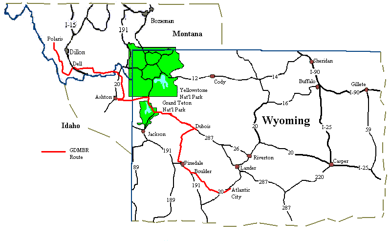
GREAT DIVIDE BIKE ROUTE SECTION 2 Grant, MT to Atlantic City, WY August 2 to August 16, 2000 31,552 miles (50,483 km) cumulative
Teasers:
"Some travelers are drawn forward by a goal lying before them in the way iron is drawn to the magnet. Others are driven on by a force lying behind them. In such a way the bowstring makes the arrow fly." View PhotosGDMBR Day 19, to Mile 108.4, Section 2 Map A Dawn came extraordinarily late. I opened my eyes to peer out the open tent fly. A heavy fog had settled over the valley obscuring the morning sunlight. I took a deep breath and choked. Smoke. It wasn't a fog of miniscule water droplets that filled the air. It was ash and smoke from the 80,000 acre fire over by the Salmon, Idaho area that had blown into the Horse Prairie overnight. Ever since we left Seeley Lake fire had been an ever present concern. We were in Helena the day the huge fire started just to the east, fire started on Priest Pass just days after we completed the climb, homes around the town of Basin were evacuated only a week after we'd passed by, Helena National Forest was closed completely 2 weeks after we'd passed, a fire near Lima Reservoir was extinguished just prior to our arrival. We smelled smoke as we rode, rode through fog like ash, heard tales of fires, read reports about the fires, asked questions about fires in our route path. Fire, fire, fire. It was the subject of cafe discussions, newspaper headlines, national news features. So far we'd been lucky. There'd been fires behind, before, and to the sides of our route. Luckily we hadn't seen any flames nor had we had to change our route. However, we expect that will change. We'll not be surprised if somewhere along the way we encounter a group of National Guard blocking our path. Till then we'll just plod along. While stuffing ourselves with an enormous and yummy breakfast at the Horse Prairie Hilton up rode a man and woman riding identical mountain bikes both towing B.O.B. trailers. Into the cafe strolled our third pair of GDMBR riders, Dan and Caroline. They had started at Kalispel a few days after we'd left and were headed as far as Silverthorne, Co. Caroline was a 53 year old medical transcriptionist, part time student, and part time mountain bike racer. She was fit, trim, energetic, had a youthful looking face, short salt and pepper gray hair, blue eyes, and was short like me. Dan had about the same height as Brian and seemed to be extremely well toned. Mountain bike racing must keep one well fit. I was surprised to find a female mountain bike racer aged 53. Even Caroline admitted she didn't start racing bikes until just 5 years ago. Prior to that she raced dogs. She got into the biking because she used a bike to train the dogs. While she lived in Florida, dog racing was her passion. But now that she lives in Kansas, where the nearest dog race arena is an 8 hour drive away, she switched to bikes. "It's something different." she said. Caroline told me she had a difficult time competing in the races because all the other women were much younger than her. She's alone in her age category. She said she'd decided to start working on the GDMBR now because she didn't expect she'd be able to do this kind of riding much into the future. "After I retire I won't be mountain biking anymore," she'd said. I'd say she was doing extremely well on the trail. They'd gotten as far as Grant in just 11 days with no days off and averaging 40 miles per day. She said she was not tired and not homesick. Even her riding partner, Dan, was inclined to admit he missed his TV, chair, and Pepsi. There's not too many 53 year old women who can hold a candle to that accomplishment. We continued to talk over the next couple days as we played leap frog along the route. It was nice having bikers going in our direction for a change We left Grant later than expected, having spent a bit more time gabbing than. The four of us headed east along Montana Rt. 324 and then south along the old Bannock to Corrine, Utah stage route. Visibility was limited to a few hundred feet as the smoke nestled in the valley. I coughed and hacked my way along the road, the ash filling my lungs. Brian and I pushed forward aimed at getting to the top of Medicine Lodge pass before the afternoon winds kicked up. Dan and Caroline lagged behind. We later learned that Caroline was just feeling tired that day. The road, which started out wide and smooth, gradually deteriorated until it was just a 2 wheel track up to the pass. The climb was gentle with undulating hills up to the last 1 1/2 miles. Then it got steep, really steep. About 1 mile of the last 1 1/2 was a pusher. Cresting the top we stopped for a short gorp break. Surrounding us were some of the driest and brownest hills we'd seen so far. Not a tree seemed to grace the tops of the nearest hills. This was all scrub land and the 2 year long drought probably enhanced the desolate appearance of the area. At least at the higher elevations the smoke cloud had cleared giving us good views and clearer air to breath. We pushed on, always fearful that a strong southerly wind would kick up making for an unpleasant, agonizing afternoon. The descent was fast, or at least as fast as riding a loaded mountain bike down a steep dirt hill can be. There was a sharp westerly turn into the wind, which by now was blowing hard, accompanied by one more short climb and that was it for hard riding that day. From here on we had an almost continual descent and a wonderful tailwind. Thank God as the desolate sage brush countryside through which we rode would have been shear misery in an uphill, headwind, hot day. We sailed. Although, sailing on dirt roads is nothing like sailing on pavement. You'll just find a nice smooth section, your speed will pick up as you glide along at a 'hardly-turn-the-crank' rate and then bang, you'll careen wheel first into a huge washboard ridge. You'll slam on the brakes all the while the bike jolts and jars across the top of the ridges. After regaining control and, hopefully, finding some smoother path, you'll now find all that momentum lost and you'll have to use more precious energy to gain speed once again. I can see now why the favorite swearword on the GDMBR is 'washboard'. As we continued downhill toward a cooling creek and shear walled canyon, leaving the desolate lands behind at last, we noticed that as the road surface was 'improved' it became harder and harder to ride. Primitive roads, two track dirt trails, are actually quite easy for a loaded mountain biker to negotiate. However, when the state or county, in their infinite wisdom, decide to improve the road they usually add a top surface consisting of loose sand and rock. Loaded bikes tend to fishtail in loose rock and the sand clumps together into those infamous washboard ridges. It gives us cause to worry each and every time the maps call for an improved road ahead. We cheer when the road becomes primitive. We'd been wondering for sometime what the mechanics behind road washboard is. Is it pneumatic tires combined with modern suspension systems, speed, and loose sand? Why are only some spots washboarded and not everywhere? Were there washboard roads back in the days of horse drawn carriages? I wonder if anyone but loaded bike tourists ever asked such silly questions about road washboard? We discovered a gorgeous campsite next to the creek right within the steep walls of the canyon. The grass covered site was as good, if not better, than many of the USFS developed campsites although it was without a table or latrine. We spent a relaxing evening soaking in the stream, watching shadows creep up the canyon wall, and watching our most favorite bird, gnat catchers, swoop and dive all around going after our most unfavorite flying insects. Two excellent and free campsites in a row, we were doing well. GDMBR Day 20 - To Lima Dan and Caroline are some of the earliest rising bike tourists we've ever met. But, they have planned a very aggressive schedule of around 40 miles per day. So I suppose they need an early start just to be sure they achieve that objective. Anyway, we were up at around 7 AM and while we were making our usual pancake breakfast they came rolling by. They had stopped some 10 miles back which means they must have been up before dawn. Caroline said they get up at 6 AM, Kansas time which means 5 AM Montana time. Well, we think we'll stick to our more relaxed pace. By the time we got dishes cleaned, packed, and were rolling down the hill the sun was already burning off the slight nighttime chill. The road continued to be a dreaded combination of smooth in spots with wicked washboard in others and we rounded a bend just to find ourselves slipping back into that smoke heavy fog we'd hoped we'd left behind the evening before. Fortunately it was to be a short day, 17 miles to the town of Dell where we hoped to get groceries and another 8 to Lima where we planned to camp. Both towns would prove to be disappointments. Dell. A little highway town that somehow has missed out on the highway boom many towns seem to experience. It boasts a grand total of 3 businesses. The Calf-A, a small, busy, and we hear very good cafe built inside what used to be an old one room, red brick school house. We looked inside and considered getting a meal, but the pile of people waiting in the cramped entry turned us away. We did peruse the assortment of strange sculptures gracing the yard. Someone with an addiction to welding has taken an odd collection of tools and other steel things and welded them into all sorts of bizarre looking statues that I suppose some would call art. Our maps call this perhaps the most unique cafe in all of Montana. It was unusual, but if this is the best Montana has to offer I'd have to wonder about the creative imagination of the average Montanan The next business, the Red Rock Inn, is the former stage stop now turned hotel. Oh, if only we were on a hotel budget I'd want to stay there. The owner, a wonderful lady who is quick start up a conversation practically dragged us off the street when we slowed down to take a closer look. She seemed as if she was hankering for a good gab session. Outside the hotel looks like a picture perfect 1890s frontier type hotel, the long covered wooden porch out front, tall false front, whitewashed clapboard front, and Red Rock Inn written in black lettering across the top. Inside was a beautiful wood floored, impeccably clean lobby and small bar. Unlike the Prairie Horse Hilton which sported all sorts of antique paraphernalia, the owners of the Red Rock choose to keep their decor simple. A few cushioned chairs, wood tables, and lamps were about it for the lobby. It had more of an upscale atmosphere. Too bad we couldn't stay just for one night. The final business is the tired and dusty Dell Mercentile. Walk inside the dimly lit store and you find rows of shelves, many of which are now empty. Refrigerators and freezer units sit at the back of the store, all turned off and empty. What few items are on the shelves are all covered in a thick layer of dust. Everything with the exception of the beer, soda, and snacks looked as if it had sat there for years and years. Dan had purchased a box of oatmeal only to discover it had an expiration date of 1998 and was full of weevils. The owner seemed as tired and old as the store. He was thin, spoke with the raspy voice of a long time smoker, and lived with an oxygen tube tied around his face. I overheard him complain to a customer about how the state was getting money from the tobacco settlement, but what were they going to do for him. As Dan said, "No one stuck that butt in his mouth each day and forced him to puff." He's a man who seems to be continuing on with this business only because he knows of nothing else to do or perhaps he can't sell. I suppose that unless some energetic person buys it and and makes some major changes, this will be one old mom and pop business that will disappear after he is gone. Considering the state of the food goods we decided to forget buying anything there. On to Lima, a bit more active and alive town. There are three choices for getting there, the highway I15, a dirt and horribly washboarded dirt frontage road, or a paved frontage road. Naturally the map take you on the dirt road. However, with a super strong headwind blowing in our faces we switched to the paved frontage road at about the half way point. Brian says, "Hey, where there are two parallel roads both with no traffic, both going where we want to be, why put up a big fight on the washboard dirt." I think he was just getting tired. In Lima is a motel that claims to be an RV park that allows tenting. What a dump. The RV part is just a parking lot right next to the highway and the tents are allowed to set up in a tiny area next to the dumpy motel where there are a few trees. In back is a crummy bathroom and shower. Cost is $5 per person. We looked at this dive and immediately searched out a better alternative. There was a tennis club a few blocks away that advertised itself as an RV park as well. We rode over to see whether they'd allow tents. We were immediately approached by a senior citizen, ice cold beer in hand, who wanted to ask the usual array of questions. We managed to quickly get in our question about whether or not they'd let us set up a tent for the night. He yelled out onto the court asking one of the tennis players our question. The answer was, "Nope. They're full." There was some sort of tennis tournament that evening and they were expecting a bunch more RVs, or so the story went. We actually believe they just didn't want any tenters as when we rode by the next morning there was plenty of space available. But all was not lost. The man out on the court proved to be the mayor of Lima and he said it'd be okay for us to camp in the city park. Which we did. So while Dan, Caroline, and the 2 Swiss bikers paid a total of $20 to get a hot shower and a campsite right next to the highway at a real dumpy motel with almost no grass, shade, and no tables we had a nice grassy, shady city park with loads of tables all to ourselves. So we had to take a cold shower from the nearby faucet. The price, absolutely free, was worth it. GDMBR Day 21 - To Upper Red Rock Lake The morning arrived with the first clouds we'd seen in weeks. Temperatures had finally dropped to a comfortable 50 degrees in the morning and it was actually raining. Not planning to ride too far this day, we slept in late, ate a leisurely breakfast at the cafe, and waited until the brief sprinkles subsided before setting out. But what we planned to ride for the day did not turn out to be what we ended up doing. The road out of Lima and up to the Centennial Valley is one of those 'improved' roads we dread. It was covered with loose rocks and sand and lots of washboard. With an uphill climb of some 600 ft to get to the top of the Lima Dam and the difficult road surface our progress was slow. Thank goodness we weren't going very far. At one point we found ourselves following along behind a picture perfect pair of horse riding cowboys and their 4 dogs. They wore the blue jeans, brown leather jackets, and cowboy hats that you see in the movies. We were gradually catching up to them and soon faced the dilemma of getting around without spooking the horses. It's easy when they're going in the opposite direction or are crossing your path, you just stop and wait for them to pass. But when you're coming from behind and a stiff wind makes yelling up a warning nearly impossible, just what do you do? Brian tried to come up behind as quietly and slowly as a bouncing, banging loaded biker can. Unfortunately, horses have good hearing and soon one of the colts got a bit antsy. The rider yells, "You'd better stop or else this colt will jump on top of you." At least the riders now knew we were there. We held up for a while as they headed out into the fields away from the road. Later on they crossed the road again well in front of us. They'd gone around the back side of the hills. Yet even at that distance the colt still eyed us nervously. At the top of Lima Dam the road became more primitive, in other words easier for us bikers. It was just a simple smooth dirt road, too bad it didn't last. We found clouds all around, dark gray storm clouds to our south soon flashed and boomed with an oncoming thunderstorm. I got worried. We were out in the middle of open country, not a building or tree in sight. The tallest things around besides us were the cows and fence posts. This was not a good place to be. We rode on hoping that being atop the insulation of our rubber bike tires would be sufficient. Once again we got lucky. The core of the storm headed to our south and we were just hit with a light sprinkle, barely enough to get the outer layers of our Gortex rain gear damp. We later learned that Dan, Caroline and the 2 Swiss got caught in the middle of the worst of the storm. So maybe being a late starter has its advantages. Taking a right at a T intersection back onto one of those awful improved roads, we headed into the river valley. Here the road went from bad to really bad. It was a soft, deep river bottom sand. For miles we swerved and swayed our way along. Just when you think you'd found some firm footing the you'd hit a soft spot and the bike would try to slide right out from under you. By the time we got to where we'd hoped to camp for the night we felt as though we'd worked as hard as any mountain pass. We were ready to quit. At the river bridge there was supposed to be informal camping. We stopped. We looked. There was only deep weeds and the putrid standing water in the very slowly moving creek. What campsite? Normally we'd see signs of campers, tire tracks, fire rings, matted down grasses or a dirt area. There was nothing of the kind. So we continued on figuring we'd find better campsites further on. Our mileage climbed to 43 as we passed one potential site, an abandoned cabin within a stand of aspen trees next to a flowing creek. It looked about perfect except for one thing, there were fresh cow pies everywhere. The air reeked with fresh cow dung. Unacceptable. The mileage continued to climb as we looked and looked in vain for good camping. An open field with a close stream was also covered in fresh cow manure, an abandoned ranch appeared to be private property, the wildlife reserve did not allow wild camping. I asked a man at the wildlife refuge headquarters if it was OK to pitch a tent there for the night and he nastily replied, "This is not a campground." So much for public servant. Our mileage went from 50 to 52 to 55 to 57 miles when we finally pulled into the only developed campground shown on the map. Gad were we exhausted. Dan, Caroline, Conrad, and Reinhardt, the Swiss, had also gathered at the Upper Red Rock Lake campground and from their description of the storm had had an even tougher day than us. They'd had pouring rain, hail, and lightening in addition to the rough road and loose sand. But at least they'd arrived early enough to wash, rest, and have a leisurely dinner. We just ate quickly and hit the sack. We vowed that the next day we'd get to the first good place for camping and that would be it, period. GDMBR Day 22 - To Macks Inn It poured all night long. A long drenching rain that we hoped would help reduce the fire danger in our area at least. By morning the air had the fresh, just washed smell of a recent rain and a light fog, this time of water, draped across the nearby mountains. The sun was shining, but clouds threatened the skies to the north. I lay in my bag for an hour listening to birds swoop right by our tent. They were in the grass behind us grabbing some yummy bug morsels and then flying off. In the distance we could hear the strange warble of the whooping cranes. This wild life refuge is the main summer breeding and feeding grounds for a large whooping crane colony. Huge, beautiful birds with incredibly long necks and a slow graceful flight flew by singly, in pairs, or small groups. Their call sounded eerie over the stillness of the calm lake water. So perhaps our ordeal at getting to this campsite was rewarded after all. Again we got a late start, but this time we were determined not to go over 30 miles distance. There would be guaranteed camping at Macks Inn, maybe even a shower and laundromat. We said good bye to Dan, Caroline, Conrad, and Reinhardt for probably the last time as they were ready to go before we even had breakfast ready. We wondered if we'd wind up leap frogging other riders somewhere further down the trail. It was a good road to Red Rock Pass, not nearly as rough or washboarded as the day before and only an easy 600 ft climb. The grade steepend for only a short 1/4 mile or so and then the rest of the ride was down, level, or a gentle bump. There was even a section of about 4 miles of great and easy single track just before Macks Inn. We stopped, found a campsite at Macks Inn RV Park, had a wonderful hot shower after 7 days without, ate a belly stuffing meal at the cafe, and decided then and there to take a day off. We're not on Dan and Caroline's schedule. We can afford a day of rest. GDMBR Day 23 - To Warm River CG You can get everything you want at Mack's Inn and Restaurant. There's motel rooms, cabins for 4, 6, or 8, RV sites, tent sites, laundry, showers, gasoline, groceries, paddle boat and canoe rental, float trips in rafts or canoes, fishing gear with a river in which to fish, ice cream, pizza, and plain old good cafe food. There seems to be something for everyone and it's one popular spot. We discovered we could pay $9 for a tent site in the National Forest campground across the street and get just flush toilets and cold water or we could pay $10.70 at Mack's Inn for a similar site with hot water and hot showers. Hot showers won hands down. ATVs, those motorized 4 wheeled monsters known as all terrain vehicles, have thoroughly invaded the section of old rail bed that comprised the next 30 miles of the route. What a mess they've made of both the rail bed and the surrounding fields. Railroad engineers used surrounding materials when they built up the railbed. These materials consist mostly of black volcanic dirt and sand. If left to settle following rains it would probably harden into a reasonably solid surface, hence the use for the rail bed. However, the big tires, big treads, heavy weight, and speed of the ATVs tears up the surface leaving only a deep loose sand. Deep sand is shear hell for biking. Not only are there deep sandy tracks on the rail bed there are similar tracks running throughout the surrounding fields. We think the ATVers are supposed to stay on the railbed, a rule they obviously ignore. What is it about some ATVers? They seems to destroy everything they touch. Crossing one of the old rail trestles we met an elderly couple and their granddaughter. The woman told us that her family has been in the area since the early 1900s. They had owned a 1500 acre farm adjacent to the railbed. They raised hay to sell to the horse guides who took visitors into the park before the rail line was built. The man said, "He got his first good crop of hay the year the rail went in. Put him out of business." Today this couple still owns a small lot near the rail bed. They told us it used to be closed to ATVers and they had tried to keep it that way. They wanted only bicycles, horses, and pedestrians, nonmotorized conveyances. But some Blue Ribbon commission forced them to open the trail to motorized vehicles. "Yeah," they sighed, "Used to be nice and quiet here until THEY came." This couple is now so discouraged that after generations of owning land in Island Park they're thinking of quitting, selling it off and not coming back. "It's just not worth it any more." they complained. We had thought that with a 30 mile old rail bed on a long downhill stretch that this day's ride would actually be quite easy. We soon discovered that with the loose sand torn up from the ATVs this wouldn't be the case. The bikes swigged and swagged down the trail and it was a real grind forcing our way through the stuff. At one point my bike even took a dive sending me sprawling onto the sand. So much for my freshly laundered pants. The trail did gradually improve the further we got from Big Spring, but it didn't become reasonably solid until the last 5 miles or so. At this point we were on a good downhill on the wall of the Warm River canyon and we could finally relax a bit to enjoy the views. What a beautiful site of a crystal clear flowing river within the steep canyon walls, not an ATV, car, or boat in sight. Heaven. We were lucky in that we arrived at the rail bed on a Monday. The ATVs we saw were few and often headed off on some trail intersecting our route rather than following it. Thus we didn't have too much flying dust. We wouldn't have wanted to try this trail on the weekend as it would have been absolutely mobbed with ATVs and we would have been eating dust the entire day. Maybe the idea of roadless wilderness, in other words a place so difficult to get into that the ATVs won't venture, isn't such a bad idea after all. GDMBR Day 24 - To South Boone Creek Once again we enter our adopted home state of Wyoming. The true continental divide enters Wyoming at the point where Montana, Idaho, and Wyoming meet. This happens to be just inside the western boundary of Yellowstone NP. It weaves its way across the park in a generally southeast direction leaving the park somewhat near its southeast corner. It continues its wig-wagging course toward the southeast through Bridger-Teton and Shoshone National Forests. Route 287 roughly parallels it toward the northeast through Dubois and Lander. Just to the southwest of Atlantic City the divide actually splits creating 2 divides with the Great Divide Basin and the Red Desert in the middle. Here the water never leaves the basin. Instead it sinks into the ground never to be seen again. Actually I guess you can sink a well if you really want. Just south of Rawlins the two divides rejoin and it continues it's souteasterly meandering to the Wyoming/Colorado border. Our route enters Wyoming further south in the sliver of Targhee NF that cuts between Yellowstone and Grand Teton. We cross the Continental Divide as we head east toward Dubois, cross again as we head south toward Pinedale, and then more or less parallel the northeast section of the split divide until reaching Rawlins. From there we head mostly due south into the Medicine Bow NF, entering Colorado. Pavement. Glorious pavement took us with all due haste from Warm River into the town of Ashton where we promptly headed across town to the big Dave's IGA. A grocery store. An honest to gosh real and large grocery store. We hadn't seen anything like this since Butte and wouldn't see another until Dubois. Time to fill both food boxes to the brim and then fill our tummies in the drive in cafe next door. Then on into the wilderness once again. After only about another 10 miles we came to the road from hell. The climb wasn't bad, just a gradual up, but the road surface sucked. We had 5 miles of some of the roughest washboard we've encountered so far. Typically we find the more traffic on a road, the worse the washboard. This road provides a good shortcut for anyone from Idaho who is heading into either Yellowstone or Grand Teton park. It's also one of those improved roads that have had an extra surface of loose stuff added to the top and that gets a new grading every year. The grading just seems to loosen up everything that would normally pack down after a while. It was 15 long miles of teeth jarring, bone rattling, bottom breaking bouncing. We were delighted to finally get to the point where the road narrowed and became more primitive. Arms numb, butts sore, backs tired from all the shaking we found the first informal campsite and called it quits for the day. Tomorrow we get our one taste of National Park traffic torture. GDMBR Day 25 - To Flagg Ranch It was 5 AM and someone was out there running one very loud lawn mower. Wait a minute, we were out in the middle of the forest. There shouldn't be anyone out there with a lawn to mow much less a lawn mower. After climbing out of the sac we looked into the sky to see a large, bright red banana shaped parachute with a pseudo ultralite aircraft hung by cables underneath. This fellow used the nearby open field as his landing strip. Actually it's not a bad arrangement. He doesn't need a pilot's license, an airport, permits, or much more than this interesting contraption and a trailer. He's got a great place to float around with fabulous views of the Grand Teton mountains all around. I can see why every morning and evening he's out there taking a quick flight. By the time we'd packed, had breakfast, and were on the road he was long gone. Not a trace of the impromptu airport in sight. Ah, an easy day. The road had become primitive for a bit, just a few washboard sections, a bit of real loose sand at one steep climb, and only a few hundred feet elevation change. It was definitely an easy section for this route at least. When we arrived up by the Flagg Ranch, just before turning onto the John D. Rockefeller Parkway and meeting the heavy stream of park traffic we found a perfect campsite. It included a table, bear resistant food box, and even a pit toilet at absolutely no cost! There was no water besides the river. But Flagg Ranch was 1/2 mile further and we could get all the water we could possible want right there. We could also take a hot shower and buy some groceries if we so chose. Unbelievable. To be in between two of the busiest National Parks in the country and maybe even the world and still be able to find a free campsite. Somehow I doubt that'll last forever. We were also in for another big surprise. The Ashton-Flagg Ranch road, for all its miserable, bumpy washboard happens to deposit the adventurous biker or car driver right in the middle of the road between Yellowstone and Grand Teton NPs. If you decide to turn right and head into Teton there is no entrance station for you to pass. In other words, there's no one to collect that $10 per biker. We'd been dreading having to pay $20 just to ride through the park on a road busy with huge RVs and other tourist who are often too busy watching for moose than watching the road. Now we discovered that we could get through without paying. This just added one more reason why riding from North to South is a whole lot better on this particular route. GDMBR Day 26 - To Turpine Meadow, Section 2 Map B Three tenths of a mile of dirt and then pavement. We would have nearly 2 full days of almost continual pavement. For this particular route this actually is almost a rest despite the fact that there would be a 3,000 ft climb on the second day. Pavement has just gotten to feel that easy. We rode up to Flagg Ranch, turned right, and hit traffic. Tons and tons of park traffic. Employees at the ranch had even remarked that the peak season was already winding down and the number of tourists had started decreasing. We couldn't believe it. Cars and RVs passing us on the road were virtually nonstop for the entire 28 miles through the park. Since we'd seen so many spectacular natural sights all along the route throughout the national forests and since we'd been to Grand Teton NP several times before we decided not to endure the crowds, fight the lines, put up with the pushing and shoving. Instead we just rode on through stopping only at an overlook to eat our lunch. The name, Grand Teton National Park, comes from a bunch of French fur trappers who were scouting the area in 1818 and 1819. There are three mountains having a peculiar shape that reminded these Frenchmen of something they sorely missed. They named the three peaks Les Trois Tetons, the three breasts. I don't suppose a little female companionship was on their minds. The British named the same mountains The Three Paps, pap being an old slang term for nipple. Now doesn't Grand Teton National Park sound much better than Grand Pap National Park. Jackson Lake and the rugged ridges flanking its western shore are the main attraction of the park. At least that seems to be what the majority of the visitors come to see. Most simply drive along the main road from Jackson to Jackson Junction only stopping at the turnouts for photos and Jackson Lake Lodge or Colter Bay Village to go shopping. Very few get off into the back country which we have found is the best part of the entire park experience. Actually we hope it stays that way. Just imagine what a mess it would be in the backcountry if all the park visitors decided to explore beyond the asphalt. The annual visitation of Yellowstone and Grand Teton is around 4 million people, three million of which arrive between June, July, and August. If you want to have a quiet park experience I'd say come in the off season. What continues to amaze us are the number of retired people, people who can come at any time of the year, who still insist on visiting during peak season. They're nuts. We learned one other interesting fact. The number of foreign visitors to the parks exceeds the entire population of Wyoming. Wyoming's population must double in summer months. On our previous auto visits to Yellowstone and Grand Teton we've always grumbled about the poor quality of the roads. They were narrow and had absolutely no shoulders to speak of. With tourists being more attentive of moose than bikers we had always avoided the parks by picking bicycle routes that go around. However, it seems that the parks have been working on improving the road situation. The John D. Rockefeller parkway between the parks was still a narrow, shoulderless road in questionable shape. But much of the road through the remainder of the park has recently been regraded and resurfaced. Lo and behold there is a shoulder. Not a Wyoming full car width size shoulder. But it is at least about 3 ft. wide. For a biker just a mere 3 feet makes all the difference in the world. Once out of the park we turned down a small side road that passed a wide assortment of fancy dude ranches with such names as Heart Six and Fir Creek. Dude ranch seems to me to be just a fancy name for stick-the-city-slicker. They all have a row of hotel rooms, a rec room, and the obligatory corral full of horses. I didn't see a huge crowd milling about any of them. They all seemed rather quiet. We did stop at the Heart Six ranch to seek out a cold soda. Brian goes in to get change for the machine and the woman at the desk displayed good Wyoming hospitality. "Is there anything I can do for you?" she asked. Brian said, "No. Just change for a soda." "How about some ice?" "I think my wife would like that." Brian replied. Boy was he right. We filled our water bottles as full as we could. An hour later when we arrived at camp we were treated to ice cold cups of Koolaide instead of the usual lukewarm. Oh how such a little thing as a Ziploc full of ice can make your day. GDMBR Day 27 - To Dubois What an easy pass Togweetu turned out to be. About 1500 ft of the climb was on dirt and the remaining on pavement. For the dirt section the maps said to "turn left and begin tough climb." About half way up the "tough" climb I asked Brian, "When does that tough climb start?" He said, "We're not through yet. Just wait." We continued up the climb coming out behind the Cowboy Resort where we met pavement once again. I never had to shift into my largest rear chain ring. Wow that was easy. Wait, it was about to get even easier. The paved section up to the pass had perhaps 2 to 6% grade at most. It was so easy. I never thought I'd think climbing a 3000 foot pass as being easy, but this one certainly was. To top off the day we had a roaring tailwind as we whisked down from the mountains into the dry plains of Wyoming. We pulled into a campground with the funky name of Circle Up Camper Court hardly feeling like we'd done any work. We'd take a rest day here before climbing up the grunt known as Union Pass. Rest day in Dubois If pronounced in proper French the town would be called something like du-bwau. The locals have reinvented the French language and now call the town de-boys. Hey, it's their town. Usually a person's last name, Dubois comes from two French words "du bois" meaning "of woods". I don't suppose the original Dubois was a woodsman. Anyway, Dubois is a town where you can still catch a cowboy strutting into a local saloon, spurs jingling at his heels. It sits right on the river which is bordered by lush green trees and grass. To the south of the river is dry scrub land and to the north an interesting rock cliff that is literally striped red, white, and orange. It does have a bit of tourist flavor; hotels, motels, restaurants, and western theme souvenir shops. It's the only place I've ever seen where hotels advertise free horse corrals with every room. We pulled in to the campground for a day of what was supposed to be rest but proved to be a day of bike repair instead. Our first order of business was to check into the library to see if we could use the Internet. Unfortunately only a volunteer staffs the library on weekends and Jane, the town's volunteer junky, is an elderly woman who probably wouldn't know where the "on" switch was located. Let's just say she was not computer literate. Boy could she talk. She told us of how just a week earlier she'd been fishing up by Union Pass and she saw the biggest bear she'd ever seen before. Quickly she gathered up her fishing stuff and headed for the truck all the while wondering how she'd warn her son who was further down the lake. Safely in the car she took a better look around. She now found herself surrounded by a herd of cows. She'd mistaken a big brown cow for a bear. Well she is blind in one eye so that's a good excuse. But for a lady who'd been born and raised around cows it's a strange mistake to make. Jane actually homesteaded in Wyoming back in 1950. We were surprised to learn that you were still able to homestead at that time. She told us about her work with school children, volunteering to man the playground to give teachers a break. She said, "The wind here is on a timer. I'd be out on that playground at noon. Every day at noon the wind starts and it just howls. I can count on just one hand the number of times it didn't." She could go on and on about the Dubois area and her involvement there. Fortunately for us another library patron came in so we could get back to the campground to get our bike work done. Otherwise we'd have been there all day. Dubois treated us to one good, western hometown event. Each and every second Saturday of August the volunteer fire department hosts a buffalo bar-b-que in the town park. It's a huge event drawing crowds from all over the valley as well as out-of-towners. They serve up a plate filled with cold slaw, corn on the cob, beans, buffalo burgers, and sliced bar-b-qued buffalo meat. Brian got an extra burger just by drooling hard. For $8 it was just the feast we needed to fuel our next day's climb over Union Pass. GDMBR Day 28 - To mile 916.3 We were up with the sun, ready to take on the daily climb of a mere 3000 ft up to Union Pass. First, though, we had to return the 9 miles west up the paved road to get to the Union Pass road. Union Pass Road is not an old stage or pioneer road. It was explored by the Astorian group, paid by John Jacob Astor to find a communication route to Astoria, OR. But its north/south direction doesn't make it a good short route that they needed. The road to the pass was actually developed when logging and the timber industry became prevalent in the area, the mid 20th century. Consequently the grades on the road are not overly steep. They had to be relatively gradual to permit high speed logging truck traffic. For a biker the pass would have been one of the easier ones on the GDMBR if it hadn't been for the loose rocks. No matter what grade you're on, even if it's down, loose rock can make for an arduous ride. Once we got to the top we knew this would be the last major climb, major meaning over 1000 ft, until Colorado. It was on our way up to Union Pass that we met our first Continental Divide National Scenic Trail hiker. He was hiking energetically down a steep section when we met. He was skinny as a rake, had flaming red hair, beard and moustache, wore lycra shorts, flannel shirt, a hat with a full brim, and sneakers. I was surprised at how small his backpack was always having figured that a hiker on such a long distance would need to carry a lot. We were curious to know how long this journey of his would take. Hiking at a rate of around 30 miles per day on roads and 20 miles on trail it would take a total of around 22 weeks. We met him after 14 weeks. I don't know if I'd be able to hike continuously 20 to 30 miles per day for 22 weeks. I've never tried much more than a weekend trip. It's an intriguing idea. Unlike most car drivers, who never think about it, we noticed he was low on water and still had about 3 miles to the next river. I gave him half of my water. Union Pass is unusual in that it really doesn't seem much like a pass. You climb for a stiff 9 miles peaking out in a cool, windy alpine meadow. At this point you are actually above the actual pass and from here you get to descend. We'd been looking at the elevation profile on the map wondering why the peak looked to be around 9800 ft while the pass elevation is 9210 ft. Now we know. Right at the pass location is a sign that basically says, "If you want to learn some interesting geology and cultural things just follow the path." So we did. Here we learned that Union Pass is one of only two triple divides in all of North America. Specifically, it is a location where three of the 7 major North American river drainage systems meet; the Colorado, Missouri, and Columbia. Water entering the Columbia winds up in the Pacific Ocean, the Missouri in the Gulf of Mexico, and the Colorado in the Gulf of California. Near the pass is a mountain, called Three Waters Mountain, on which water falling on each of three faces winds up in gulfs and oceans thousands apart. The signs described Union Pass as more of a knob, a mound covered with winding, meandering streams. It's so hard to tell which direction a stream will head that many an experienced mountain man followed the right river up only the descend down the wrong stream. Perhaps that's why no one ever wanted to build a road to the pass until the 20th century. Rolling hills marked our ride over the top of this knob as we stayed up in the cool elevations of 9000 ft for a good 30 miles. Then there was a bumpy, bouncy, steep ride down to the shores of the Green River, the river by which the famous mountain man rendezvous took place during the 1820s to 1840s beaver fur trade. Dropping out of the trees, the camping options looked sunny and hot. So we continued on and on finally coming to the only batch of trees we'd seen for miles. It also happened to be a USFS campground. We pitched our tent under the shade of green pine trees clinging to the shore of the Green River. GDMBR Day 29 - To Pinedale This is ranching country. It is filled with enormous ranch lands all partitioned out by barbed wire fencing and, in the cases of one of those millionaire ranchers we've heard about, all wood fencing. Isolated in the middle of most ranches is the ranch complex, a hodge podge system of barns, out buildings, sheds, and odds and ends of equipment, old cars, and the big ranch house. Extended families or ranch hands must live in the miscellaneous extra houses. A favorite decoration for nearly all ranches is the big wood gateway at the front of the driveway. It's just a bunch of huge logs buried vertically in the ground, usually 2 short and one real long on each side. A single horizontal log tops the gate. The top log can be straight or curved, can have a sign announcing the name of the ranch hanging below, or maybe it has black iron figurines of horses, cows, and cowboys on top. Some one, sometime decided that to have a proper ranch you've got to have the proper gateway. It doesn't matter that the rest of the fence around is just simple barbed wire. It was an easy ride into the town of Pinedale, mostly paved with a short 4 mile stretch of mixed rough and smooth dirt. We had planned to spend another rest day in Pinedale before heading out into the dreaded Great Divide Basin and Red Desert, but our first human encounter in town immediately changed our minds. The Pinedale Campground is located just off the town's main street and from the first moment we saw it we worried. It was a dive, one of those places where people dump old, run down RVs and live is a semi state of permanence. Only a few bushes in the back provided any shade. Well, we did want the rest so we entered the office still intending to stay. An older woman stood behind the counter, rubbing her hands together. She said nothing. Brian said, "Hello." A muttered grunt was the only reply. Brian hesitated for a second and then tried again, "Do you have tent sites." A terse, "Yes" was all we got back. Brian looks at me and says, "Do you really want to stay here. This woman is real unfriendly." Before I could say anything we were out the door wondering what our next move would be. Fortunately the rest of the inhabitants of Pinedale proved to be far nicer. We got great tips about the upcoming trail from a man at the hardware store. "You know the section south of here between Pinedale and Boulder," he said, "Well, don't do it. It's so soft you can't even get through on an unloaded bike. It's not even a trail. They're supposed to make an addendum telling folks to just take the highway, but they haven't yet." Good advice as a lady we talked to in the BLM office confirmed the condition of the trail, it's not well marked and very soft. The folks in the hotel we chose for that night were also very friendly and the lady at the BLM office was remarkable for a government employee. She even wanted to send a letter to ACA to get a copy of the map so she could go out into the BLM and research the route herself. She said, "They tell folks to check with us on the water situation, but they never even sent us a map to know where the route it." The only thing we didn't like about Pinedale were the prices. Hotels and motels were very expensive for their level of quality and even the grocery store seemed rather high. It is high tourist season and they are on the route to Jackson Hole so I guess they get what the market will pay. This did mean we did not get an extra rest day. Instead we loaded up on 5 days of food for the next remote section and headed onward the very next day. GDMBR Day 30 - To Mile 999.9 We needed to prepare for the waterless Great Divide Basin. It's a section of 125 miles where the only water sources are the Sweetwater River at the beginning, the Arapaho Creek and a spring near the now mud hole A&M reservoir, and Rawlins at the other end. We spent the night worrying about whether the spring and creek would be flowing. But a discussion with the nice lady in the BLM office quelled our fears. She said, "We haven't had any reports of problems so it seems that bikers are finding water. Not only are the creeks usually running, but there are also ranches with wells. Just look for those windmills. They may look primitive, but there'll be water" Feeling a bit more reassured, but still planning to carry extra water, we pressed on. A tail wind gave us a good solid push as we raced along the 12 miles of pavement between Pinedale and Boulder and then the additional 18 miles to the pavement's end at a nonexistent town called Big Sandy. From here to the Big Sandy creek the road was difficult, loose rock for the first miles and then some real soft sand just up to the river. We dropped down to the bridge across the river and stopped to read the interpretive sign. The road we'd been following roughly paralleled the Lander Cutoff section of the old Oregon trail. The bridge that now spans the Big Sandy creek is located where the wagon trains used to cross. Looking at the hill just to the east of the bridge we could see the old wagon ruts running down its side. There are supposed to be emigrant graves nearby, but we didn't find them. We did find that the cool shade just under the bridge was a perfect place for lunch. There's a steep climb out of the Big Sandy Creek over loose rock and sand that invariably has been piled up into those rugged washboards that we've grown to dread. Weaving back and forth across the road, we did manage to find some semblance of smooth road. Even still, the soft sand made for energy draining riding. At one point I got too close to the edge of the graded road bed and the sand slipped out from under the tire. Down on my side I went, banging my head hard on the road. It took a while for the headache to subside and I was a little dazed for the rest of the day. But, thank goodness for helmets. The new hole in the side told us that I'd hit one real sharp rock. Hate for that to have been my head. Setting up camp on the side of a mountain overlooking the Wind River Range, we prepared ourselves for a relaxing and quiet evening with fabulous mountain views. But this site turned out to be a favorite horse trail for the dude ranch located down the hill next to the Big Sandy River. Much to our surprise we had an entire horse train of around 10 people go right by our camp and another 2 girls separate from that group later. We hadn't expected to have so many guests for dinner. We hear the reason so many ranches are turning to dude ranching is that dudes are much easier to winter than cattle. The dudes just go away. GDMBR Day 31, To Atlantic City, End of Section 2 Past the Little Sandy Creek the road improved dramatically and we flew all the way to pavement and the famous South Pass. Emigrants crossing on the many westward bound trails all had to cross the Rocky Mountains. It was a crossing many looked forward to with great trepidation. However, unlike all of the other passes, with the exception of the one down near El Paso, TX, this crossing proved to be no big deal. It's just a small rise over a hill and you've crossed the Continental Divide. Many a pioneer passed this point not even realizing they'd crossed such an important milestone. It's just too bad the mountains further west would prove to be so much more taxing. Historians estimate that in the period from 1843, when the first wagon train of 1,000 crossed, to 1912, the last recorded train, some 500,000 people passed this way most of them walking. We ate a quick lunch at one of Wyoming's unique energy efficient rest stops. They're built in such a way to take advantage of the winter sun to warm the building and then have sloped roofs that keep the searing summer sun out. We've not seen rest areas such as these in any other state. Of course only Wyoming would think of building rest areas like these, but I'm not biased am I? After that we were on our way to the South Pass City Historical State Park. Even though South Pass City did not come about due to the emigration, it is recognized as Wyoming's second established town. It, along with Atlantic City located another 4 miles northeast and Miner's Delight a town that no longer exists, was another one of those mining boom and bust towns. The Carissa mine began operation in 1867 and then the rush was on. Population in the three towns soared to around 2,000 with dozens of mines and hundreds of placer claims in operation. Naturally this brought the businessmen; butchers, general stores, clothing stores, saw mills, blacksmiths, saloons, and prostitutes all arrived in large numbers. The bust came shortly thereafter. By 1872 most miners became discouraged by the lack of a large mother lode and moved on. Less than 100 people remained by 1875. Yet other booms came and went as new technologies were developed. There was a large hydraulic operation, a copper mine, a dredge, and a strip mine all of which fueled booms in the 1880s. 1890s, and 1930s. Even today there are a few persistent prospectors out in the creeks around South Pass City panning and digging for ore. The more than 300 buildings which once stood in the vicinity of South Pass City gradually became dilapidated due to lack of care and one-by-one were reclaimed by nature. The town was in danger of becoming just a memory with a few foundations and depressions in the earth remaining. To the rescue came the Wyoming 75th Anniversary Commission. They purchased the entire town in 1966 as a birthday present for the state. Since then the remaining 30 log and frame buildings have been carefully restored and furnished with period artifacts. They've even placed plastic food on the table of the Inn, fake beer and cards in the saloon. To walk down the street and look in the windows is to have one of the best peeks into mining boom town life that we've seen. One other important historical event occurred in South Pass City. In 1869 the first territorial legislature, William Bright, a representative from South Pass City introduced a women's suffrage bill. It was passed and signed by the governor in December 1869. Today Wyoming is recognized as being the first government in the world to give women the right to vote and hold elected office. In February 1870 the county commissioners appointed Esther Morris as justice of the peace. Supposedly she is the first woman in the world to hold this office. One wouldn't think of Wyoming, a place out in the wild wild west, as being so progressive. There's a statue of Esther standing in front of the state capitol building in Cheyenne. "Go up the road. Where it makes that first dip, turn left. Right there you can get on old railroad bed and it'll save you riding up and down two gullies." the state park ranger told us. We're all for saving a few extra climbs. As we left the park the sky to the northwest turned black and the wind began to howl. It was a struggle staying on the bikes as well as climbing up the steep hill just to the north of South Pass City. Seeing the road take another steep dip and climb we were ever so grateful to see that nice level railbed just to to the left. Even still it took concentration and muscle to keep the bikes going in a straight line. I watched to the right as the road dipped, climbed, and dipped once again. To the left of the rail bed were a series of steep gullies, steeper than those taken by the road. As we rode past one I looked down to see a strange gray fog or mist lying among the bushes. Thinking about it I realized that there was no way there could be any sort of fog in this arid climate. Looking again to see if it was my imagination I still saw the gray fog but also blackened bushes. Fire. It had to be a smoldering fire deep in that gully. "Great," I thought, "I'll bet no one knows about it and that's the last thing they need around here." "Is there a local sheriff around I can report a possible fire to?" I asked the lady who owns the Dredge restaurant in Atlantic City. Suddenly she looked horrified and a bit lost. "All our fire engines have been sent away to fight other fires," she said, "We've been worried about fires starting around here since we have no one around." She called around to try to find any one associated with the fire department, but none were around. Finally she dialed 911. I gave the operator the location and a description of what I saw. We all just hoped they'd get someone out to take a look soon, before the high winds had a chance to turn it into something more dangerous. Brian and I headed out to the BLM campground. Soon after arriving we saw a fire engine pass by. A couple of hours later two engines returned. So either it was so small they could put it out very quickly or I really was imagining things. Either way, if I hadn't reported it and later heard of a terrible fire destroying South Pass City or other homes nearby I would never have forgiven myself. This year it's better safe than sorry when fire is concerned. As an aside, one week after leaving the Flagg Ranch area near Yellowstone we read that they had to evacuate the resort due to a fire right there.
Appendix A - Route August 2, 50.07 mi to GDMBR mi 608.4, Section 2 Map A
Appendix B - Campsites or hotels August 2, Roadside campsite at mile 80 |
|
Copyright © 1995-2011 by Caryl L. Bergeron - Distribution for personal use permitted. Distribution for other uses with written permission.
Acknowledgements
|