| Caryl and Brian's World Bike Tour |
|
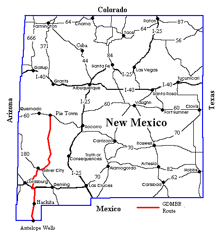
Great Divide Bicycle Route 2000 (Section 6) |
![]()
![]()
![]()
![]()
|
|
Pie Town, NM to Antelope Wells, NM Oct 2 to Oct 13, 2000 33,116 miles (53,413 km) cumulative
Teasers:
"The desert breeds reserve. It is so big that one's own plans and projects seem too little to be talked about. Also, there is so much time to say anything that one continually puts it off and ends by never saying it at all." View PhotosGDMBR Day 66 - To Valle Tio Vences CG, Apache NF, Section 6, Map AThis was it, the last section of the Great Divide Mountain Bike Route, the last 303 miles to the Mexican Border, and our last 2 weeks summer/fall bike touring. It begins with a five day ride south from Pie Town to Silver City through some mighty dry country with absolutely no services for the first 155 miles. Leaving Pie Town we gradually climbed on an extremely nice dirt road. This seemed even more extraordinary considering the rough and sandy road we'd ridden just across Rt. 60. We climbed up rolling hills, crossed the continental divide, turned right, rolled up and down more hills, and crossed the divide once again. This was a strange crossing. We sat on one hill looking down the road to an even higher hill, yet this shorter hill was supposed to be the continental divide. Go figure. Rolling hills through pinon and juniper forests took us up a rise, down into a supposed river valley, and then gradually up to the next divide crossing. Three crossings in one day is a record for us. The road surface deteriorated a bit, but remained pretty much washboard free and solid. Just a few soft spots had the bikes swishing and swerving in the sand. We're hoping the rest of the dirt road riding is as good. Stopping to check the maps at the intersection with Rt. 214, up comes one of those old, little, foreign station wagons. This was one beat up ranch car, dents and dings all over as well as boards replacing rear side windows. I pulled over to let it pass, but the driver decided this would be a good time to have a chat. He pulled over even further than I had and stopped the engine. Gilbert was a skinny man with dark complexion, black curly hair and week old beard, black, gray, and white stripped and well worn shirt, and a well worn white felt cowboy hat. What rancher out on this route that we've met hasn't had a cowboy hat. He started with a bit of bad news. La Mangas work center, where we'd hoped to get water, was closed. It had been moved to Quemado. So our best water bet was Valle Tio Vences spring, which he said should have water if it hasn't been too dry. He was telling us that it was so dry that the forest was closed for some time. However, some bicyclists came through, ignoring the signs I guess. They started a fire to cook dinner and it got away from them. That got the Forest Service a bit up tight and they started being much stricter. Gilbert said that some of the ranchers were a bit upset but he's never had any problems with the bikers. As usual, he thought we were crazy and was amazed when we told him we'd ridden from Pie Town that morning. They're just not used to the idea that you can ride good distances each day on a bike. We only chatted for a few minutes and then we had to move on. He was headed back to Pie Town and we were going to Valle Tio Vences campground. Not more than 4 miles up we passed by what used to be the La Mangas work center. It's not much more than a small, yellow shack. That's it. There's no water to be had there. So on we went still hoping for a gushing spring up at Valle Tio Vences. Ok so the hills and climbing were not done and over with at Grants. Continuing to climb up to the 21st crossing we once again entered Ponderosa Pine forests. It was so nice to be back in the shade of tall pine trees. There was a bit of a steep grunt getting to the top and then a nice downhill to the campground. Valle Tio Vences is intended to be a campground for people with horses. It's got 2 public corrals and 4 of the longest picnic tables we've ever seen. Supposedly the 2 tanks in the corrals are to hold water. But, not this year. Even the spring, just up the hill across from the campground, barely had a little puddle in it. It appears to have stopped running and the water within the concrete enclosure is gradually evaporating away. If there's no snow this year and no monsoon season next summer I doubt there will be any water left in that spring at all. Fortunately for us there happened to be a day hiker parked at the campground. He had "gallons and gallons" of water which he gladly gave to us. On the route before the 21st divide crossing we had seen one cattle pond that still had some water and a couple of creeks that were just barely flowing. Otherwise there was nothing. Thanks to the hiker, we'd have no trouble making it to the Beaverhead Work Center. GDMBR Day 67 - To mi. 2230Still loaded with extra water and still having enough food for 3 more days we made our way out of the Apache National Forest, across the Plains of San Augustine, and finally into the last National Forest, the Gila. It was a 10 mile mostly downhill ride on a nice, relatively smooth dirt road to the intersection with New Mexico Rt. 12. We had stopped briefly at the point where the map says, "Fenced pond" and wondered where this pond might be. Dried to the bone this year I suppose. Rt. 12, a lonely road stretching into the horizon in both directions has perhaps one car every 10 minutes passing by. Yet, it's still wide and smooth with brand new asphalt. Why is it some states have such great roads yet others have such crummy ones. New Mexican paved roads are incredible. Although the dirt roads aren't. The supposed farm house on the corner looked more like an abandoned ranch, windows boarded and miscellaneous junk all around. We didn't happen to need any water so we didn't check for residents. But, anyone going south to north should make sure their water jugs are full at this point. Crossing Rt. 12 we headed across the western side of the vast grassy expanse known as the Plains of San Augustine. There's not much there, a few ranches some occupied and some abandoned, a power line, some windmills and lots of brown grass. Surprisingly there were almost no cows. Gilbert, who we met the day before, had told us that due to the drought and other factors a lot of the ranchers were selling their cattle. "Moving to the towns I suppose." he'd said. So perhaps that's why we didn't see any cows out in the plains, just one big black one that is. Unfortunately that also meant that most of the windmills weren't running. Why keep a windmill maintained if you don't have any cows who need it. We continued along this newly graded road literally following behind the grader which made for soft dirt riding. We were relieved to finally catch up with and pass the graders as the road became a much better hard packed surface. Wide open grass lands stayed to our left, rolling hills with some trees to our right. We did pass one operating windmill while passing the plains. It was about 10 miles south of the intersection with Rt. 12. Wind vanes were turning rapidly under the influence of the usual afternoon southerly winds and water was gushing into the waiting tank. We decided to skip this windmill thinking we had enough water. It takes about 20 miles to finally leave the plains and once again enter sparse pine forests of the Gila National Forest. Oddly it seems like the road drops a distance and then enters forest, an opposite effect from what we normally expect. At an elevation of only around 7,000 ft we were surprised to find nice, large pines, Douglas firs I think. We entered the La Jolla canyon where the road twists and turns back and forth following the contours of the canyon walls. It was here we found the second operating windmill. Actually the windmill no longer works. Instead a generator driven pump fills the tank. It's located between the two informal campsites listed on the map just to the west of the road. The Aermoter windmill sits up on a hill with the more modern pump and generator underneath. A long rusty pipe goes to the first of 2 tanks. This tank is huge, absolutely huge. It's a good 10 ft high and 15 ft in diameter. The second tank, closer to the road than the large tank, is only about 2 ft high and 8 ft in diameter. The cows can access the second tank but not the first. Climbing a ladder at the back of the larger tank to have a look we discovered it was absolutely full of not bad looking water. Judging by the tadpoles swimming around it must have been pretty good. Actually, we were wondering how the tadpoles got into the tank and how the ensuing frogs get out. Good mystery. So, thinking that having extra water is better than coming up short, we decided to filter an extra gallon. But, the large tank looked almost inviting enough to dive right in. I wonder just how many cyclists may, in fact, do just that. Loaded with lots of water for the evening and next day we rode just 4 more miles through the pretty canyon before finding a suitable campsite under the shade of three of those large pines. GDMBR Day 68 - To Beaverhead Work Center, Gila NFThunder rumbled across the sky early in the morning and a light drizzle pittered down upon the tent. Not enough to give the ground the good soaking it needs, but enough to convince us to turn over in bed and wait a few more minutes. When we finally decided to get our butts up and going, we discovered gray clouds swirling around overhead and blue sky to the west. Clouds would follow us for much of the rest of the day, but only a few sprinkles would actually hit ground. Oh well, it kept things cool for riding at least. The route finished it's meandering through the La Jolla Canyon on a nice, smooth clay road. From here it turned left along the wide open meadow called Collins Park. This was truly one strange road. It's one of those "improved" gravel roads that hasn't seen much maintenance in recent months (years?). The loose black rock had collected in the center and along the edges. Whereas where the tires normally rolled was a sort of a shallow ditch filled with those nasty washboard bumps. So like a gymnast walking along a balance beam, we found ourselves carefully balancing the bikes on a narrow ridge between the loose rock along the center and the washboard filled ditch. We usually succeeded, however like those gymnasts, we occasionally fell off to bump and bang on the washboard. At least this section of road wasn't too horribly long and there was some place we could get a smooth ride, unlike that road from Hell back near Cuba. Soon we were back on a more unimproved dirt road with a surface that alternated between washboard, soft sand, and hard packed. Most of it was hard packed which meant we made reasonably good time to the Beaverhead Work Center despite the usual strong southerly headwind. Rounding a corner we entered an area noted as having "dramatically different" landscape on the map. It certainly was different. If there was anywhere along this entire route that looked any more desolate it was here and the Great Divide Basin. We were surrounded by rolling hills that were covered by a strange looking, very low growing ground cover. It was light tan covered in white dead stuff. It made the hillsides look as if they were covered in a layer of salt. Otherwise there was absolutely no green living thing within sight. Gradually the white gave way to just tan, but green was not to be seen for at least 10 miles. Stopping at an intersection where 3 wide, tan dirt roads headed in one direction and 1 continued south, we waited for a light blue pick-up truck to ramble by. It's side was marked with the insignia of the nearby ranch. The usual cowboy hat toting rancher driving the truck came to a halt and asked, "You Ok on water?" "We're headed to the Beaverhead Work Center where we hope to get water if they're open." we replied. "You'll be able to get water there," he assured us. Then he added, "Some of the bikers have said that the map shows springs that have been dry for 40 years." No wonder water's been so hard to find. We made one sharp right turn next to a corral, climbed a hill, and finally descended into something other than barren looking landscape. We were following along what appears to occasionally be a long marsh, or maybe even a river. To our right was a fabulous rocky cliff covered with bushes which had just turned color for the winter. It looked better than the most carefully planned rock garden. Nature is a great landscaper we've found. Not too much further on we pulled into the Beaverhead Work Center where we promptly filled up everything we had with water. Oh how wonderful water on tap can seem after so many miles with almost none. Beaverhead is a huge facility with what looks like 3 or 4 small office buildings, a couple large garages, 3 residential buildings, and a few other small buildings scattered about. Asking about water ahead, we finally got a good answer. The woman called ahead to the Mimbres ranger station where they absolutely assured us that there was water in the Black Canyon Creek and possibly intermittent water in Rocky Canyon. For once we got a straight answer. During this conversation we learned that they don't mind bikers camping right there at the work center. Didn't have to twist our arms. A nice flat spot, water on tap, pit toilet, picnic table, even a soda machine. Luxury for this route. GDMBR Day 69 - To Black Canyon CG, Gila NFThe road from Hell squared. That's the only way to describe the route south of the Beaverhead Work Center. There's a single road that traverses a thin region of National Forest sandwiched between two regions of the Gila National Wilderness. The road, according to the Forest Service map, starts as "improved gravel" for the first 8 miles to the Wall Lake. It than changes to "improved dirt" from there to the Mimbres ranger station. What they don't tell you is that there are some mighty super steep climbs along the way. Looking at the ACA bike map one gets the impression that there's a nice, gradual climb with some gentle rolling ups and downs. Somewhere in the text is a comment that for every steep descent there's a corresponding steep climb. However, nowhere in the text or on the elevation profile do they give any indication of where the climbs are, how many there are, how high the elevation, and how long the climb. Having seen similar elevation profiles for some of the flatter sections we naturally assumed the road would be fairly flat and the steep climbs that there were would be short. Egad were we wrong, or should I say mislead by the crummy elevation profile. As we grunted up and down climb after climb after climb we started keeping track. It turns out there are no less than 5 steep, long climbs of a minimum 500 ft. elevation gain each before even reaching the steep downhill into the Black Canyon campground. This last descent, by the way, happens to be about the only one shown on the map to be of any significant size and happens to be shown wrong as well. All right, so we had these 5 major climbs probably amounting to somewhere around 2,000 ft. climb or more. But this was not what made us declare this to be the "road from Hell squared." After all we've ridden dirt roads with total elevation gains of 3,000 ft. in one day and didn't feel nearly as tired as we felt at the end of this day. It was the road surface itself that added so much to our misery. It just so happened the Forest Service decided to blade the road probably just a few days before our arrival. Blading may help the road surface for a car, but it turns it into a torture for a biker. It serves to loosen all the rocks that used to be firmly embedded in the dirt, it breaks up all the hard packed dirt making for loose sand, and pulls all the pebbles out from the road making for loose gravel. The amount of effort needed to crank a loaded bike over a newly bladed road must be more than double that of a nice, old hard packed road. Add that to the extra steep climbs and by the time we finally arrived at Black Canyon campground we could go no further. We were totally beat. There were some pretty spots along the way, thank goodness. Wall Lake, for instance, is a pretty little mountain lake surrounded by tall reeds. The large rock cliff adjacent to one side is clearly what gave it its name. Birds abounded in and around the lake this time of year, swooping and soaring over our heads and singing their songs to the sky. We were amazed to see that the creek which feeds the lake was still flowing with a pretty good stream of water. But this is the east fork of the Gila river, so I suppose it should be expected to have water even in the worst drought. The climbs took us up on the mountain ridge tops again and again. From each peak we could get great views all across the Gila wilderness. The hills are covered with a good spread of green pines, but not nearly as dense as further north. At one point we caught glimpses of smoke plumes from the two fires that were burning in the forest. We'd spoken to the fire manager, a man on assignment from the Carson NF in Nevada, the night before while at the Beaverhead Work Center. He told us that these two fires were low level fires that were being allowed to burn. They weren't very hot, were burning just the low lying shrubs and ground needles, and weren't moving very fast. Besides, there's no structures anywhere near by so why not let them clear out some of the undergrowth. He told us that prescribed burning is real easy in the Gila primarily because there's so little population nearby and the ground fuel isn't that thick. So they were also doing a few prescribed burns as well. After all the problems with fires this past summer there'll be a lot more efforts to do burns in more forests. After somehow getting down the now loose and rocky road to the Black Canyon campground we set up camp and used the little bit of water remaining in the stream to wash up. It was fortunate that the stream was still flowing as without it we may not have had enough water for the next day's even tougher climbs. As we set up camp we spotted a pick-up truck gingerly making its way down the steep switchbacked road we'd just descended. When they came to the stream crossing they were about to head on. Instead they stopped, turned, and came into the campground. A man climbs out of the truck and says, "That's your bike tracks we've been following since Beaverhead. Wow. You guys must be Olympic style bikers." It's not too often that car drivers are so amazed that we've climbed the hills we have that they stop to make a comment. This just goes to show what a super hard day we'd had. Just wait till tomorrow. It'll only get worse. GDMBR Day 70 - To mi. 2329The Road from Hell Squared continues. The climb out of Black Canyon is a 2.6 mile extremely steep, loose rock and gravel road with about 3 tight switchbacks. It took us over an hour to finally crest the top which means it had to be around a 1000 ft. climb. As I watched the road surface I began to realize that the tread marks made by the grader seemed so fresh that they could have been made just hours earlier. Lo and behold I was not far off. Just a couple miles after reaching the end of the steepest part of the climb we found that blasted blader. Brian pulls up to it and asks, "Can I blow it up? Come on let's blow it up." Tempting. However, now that we were past it we expected the road to get better anyway, so no need to do any real damage. Just give it a good, swift kick or two. We were hoping for a dramatic improvement in the road. Alas even that was not to be. Even though the dirt was more solid and there was not nearly as much loose gravel, this Wall Lake road is never a very good road. After a few more rollers on top of the mesa just south of Black Canyon we started on the steep descent into Rocky Canyon. The descent was made even more perilous by the numerous stream crossings. The map mentions crossing the stream bed only once, but in fact you cross it up to 10 times. Each crossing is marked by a steep drop into a baseball size rock strewn gully and a subsequent steep climb back onto the road surface. I can't begin to count the number of times while going over these rocks my bike decided to jump to one side while I was trying to steer it in the other direction. We're still amazed neither of us took a dive on this section. In wetter years Rocky Canyon would be an absolutely beautiful spot for camping. It has large live oaks surrounding the rocky bottomed creek. However, this year Rocky Canyon creek was absolutely dry. Not a drop of water to be found. We were told that you might, just might, find water if you hike upstream away from the road. But, we had sufficient water from the night before and really didn't want to carry any additional weight up that extra 1 1/2 mile steep climb out of this canyon. So water was not a concern for us.One more real steep climb out of Rocky Canyon, a bunch more rollers on top of the mesa, and finally, after about 45 miles of shear Hell, we began the long, steep descent into the Mimbres river valley. As we descended a man driving a pick-up with slide in camper stopped and commented, "You guys on bicycles sure are tougher than me." Maybe that or just nuttier. When we, at last, hit pavement Brian got off his bike, knelt down, and blessed that smooth, solid surface. It seems to us Adventure Cycling saved the worst and most difficult for last. It's not that the road was particularly worse than the absolute worst road we'd been on. It was just that the combination of the rough surface, super steep climbs, and 45 miles of distance was just too much. It was so wonderful to get to pavement. It felt like flying, smooth sailing, going with the wind. That's how incredibly easy and fast the pavement felt. We quickly cruised into Mimbres where we stocked up on food for dinner. Then there was one more relatively painless climb up the Georgetown road where, after several failed attempts, we located a good camp site. Funny thing was at the Mimbres ranger station a carpenter commented that the Georgetown road was one rough road. Yet we found it so easy and smooth compared to the road from Hell that we actually enjoyed the climb. It was actually a fun road. Well, he'd never been up Wall Lake road so I suppose that was a reasonable excuse. GDMBR Day 71 to Silver City, NM, 2 days restA train whistle blew at about 5 AM followed by the distant rumble of thunder. "Odd." I thought. A few minutes the cycle repeated, train whistle followed by thunder. At least 5 separate times we heard this pattern. Not a train and not thunder, it was the sound of explosives going off at the Santa Rita mine some 5 miles away. I suppose they spend all night preparing the explosives, set them off early in the morning, and then spend all day trucking the ore out. Imagine living within earshot of this. It'd be the most unusual morning alarm I could possibly think of. It certainly had us up and about earlier than usual. We had just about 2 more miles climb to the top where we took a few minutes to peruse the old Georgetown cemetery. It is surprisingly large considering the town of Georgetown no longer exists. There are graves dating all the way from the very early 1900s to as late as 1997. I guess old miners who once lived there are still asking to be interred there. There's a guide contained within a zippered folder hanging on the gate which, I guess, is quite useful for genealogists. We noted that the graves on the eastern half are all written in Spanish while those on the western half are all in English. On purpose? The one most interesting grave marker was for an old Spanish man, Encinos who died in 1915 if I recall correctly. It's one of those old, rusty irons markers, the only one we saw in the cemetery. The purported age of that man was listed as 120 years, in Spanish "al edad de 120 anos." Now, we're not saying that it's not possible for this man to have been 120 years old. But, in the year 1795 I don't think records were kept quite as methodically as today and it would not surprise me if he may not have really known his own true birth date. I support this by the fact that while many of the graves gave both birth and death dates, his only gave date of death and number of years. In any event, he probably was one very, very old man no matter if he was 120 or 100. When we turned onto the pavement headed toward Silver City we felt delight in the knowledge that there was only bout 27 miles of dirt left. Riding dirt roads has been a challenge and certainly a great experience. However, at this particular moment in time we were sure ready for some serious pavement riding for a while, that is. Given a month or two of just pavement and I'm sure we'll long for dirt once again. It was just about at this intersection, at the Chino Mining Co. overlook, that we met the first bike tourist we'd seen since meeting Niles out of Del Norte. This man was with a group doing the ACA southern cross country route. He is just in the beginning of his tour, having started in San Diego and being headed for St. Augustine, Fl. He'd left out of Silver City just that morning and was not in particularly good mood for riding. A late start, headwinds, and the upcoming 1000 ft. or so climb had him feeling a bit down. When he heard we'd just come off the Great Divide route his spirits picked up. After all, what's his little 1000 ft pavement climb compared to what we'd just endured. We were more than glad to give him a little boost. For us the rest of the day's ride consisted of one long down to the town of Santa Clara and then a series of about five 200 ft. rolling hills into the town of Silver City where we promptly set up camp in the cozy Silver City RV park. Ok so now I think I can safely say, "It's all downhill from here." GDMBR Day 72 - To SeparSilver City is such a friendly and historic town. Of course, it's an old mining town, with a name like Silver City how could it possibly be otherwise. Even today it's the main supply point for several still operating mines in the area including the huge Chino mine just east of town. The old part of town lies across the creek affectionately known as the "big ditch". Here you find a main street lined with old 1800s buildings now filled with upscale stores and cafes. It is surrounded with equally old 1800s residential buildings, no cookie cutter style developments. On the hill just west of town is the Western New Mexican University, a liberal arts college with approximately 5,000 students. Outside of the old sections of town you find every possible modern convenience you could ever want. There's every imaginable fast food restaurant along the main Rt. 180 north of town, video rental stores, two regular grocery stores, a huge Wal-Mart supercenter, auto parts stores, a western clothing store, a J.C. Penny catalogue store, etc. You name it, it's here. Yet it's still just a small town with a small town atmosphere. We've heard a lot of people say they'd like to move or will be planning to move to Silver City. It's become such a popular place to live that it's quickly growing, not at a city's exponential rate, but certainly at a steady pace. Surprisingly with a student population approximately half the size of the town's total population you really don't get a real feeling that Silver City is a college town. There just aren't book toting college students wandering around the streets all day long. In fact, it seems that the only time there is a noticeable number of students around is during the weekend cruise ritual. Every Friday and Saturday night there is a bumper to bumper parade of cars driving up the main street to the Lotta Burger on one end, turning around, and driving back to the other end of town. Windows are wide open, a variety of music from hard rock to heavy metal beats against the night air, yelling and screaming from car to car is the norm. It's a bizarre ritual that appears to have absolutely no purpose whatsoever. In all our travels the only place where we've seen teenagers and young adults with so much money, so much time, so much disregard for energy abuse is the US. No where else will you find young people cruising every weekend night. Into each life some rain must fall, We waited for 2 days in Silver City while one extremely nasty cold front blasted its way south from the Arctic. For one entire day we kept ourselves warm by spending time in the public library. Outside temperatures barely reached the high 40s and a day long frigid mist kept us shivering. Heather and Brandon, another cycling couple who'd been following us for weeks, made an attempt to ride toward Separ. They managed to get just 3 miles down the road and then they gave up. It was too cold, too miserable. We saw them last also taking advantage of the warm heat in the library. It's one thing to ride in miserable weather when you know you'll be in a nice campground having a nice hot shower later in the day. It's an entirely different matter if you're going to be out in the middle of nowhere. The following day dark clouds swirled around the sky with just blotches of blue sky showing here and there. We decided to head on. So we rode south along the paved Rt. 90 toward Lordsburg. Once again the elevation profile failed to show a good, long 4 mile climb. But, it was paved which made the effort a whole lot easier. After about 20 miles we turned left to begin the last 37 miles of dirt, although the maps erroneously showed just 20 miles. Fortunately the rain hadn't been hard enough to cause flooding or mud. The road was in good shape, only a few spots of washboard and some soft areas that were a bit tricky to see. We gradually dropped along a dry stream bed through a canyon bordered by pinon pine trees. The sandy areas kept us on our toes, ready for the bikes to slip out to one side at any instant. There was one more climb up to the second to last divide crossing and we descended into the true southwestern desert. There would be no more trees, just scrub trees, agave type cacti, things that sting, stink, and stick. Tarantulas are prevalent as well as rattle snakes. In fact, we hear there's one huge rattler living under an abandoned house just south of the large Thorn ranch. A biker we met later had the unfortunate luck to be bitten by this fellow. Fortunately it was within a mile of Thorn ranch, there were people at the ranch, and he was not riding alone. With so little distance left to complete and all of it being brown desert environment, we were more than anxious to be done. We rode a full 52 miles down to I10 and the supposed town of Separ. Just a sandy site next to a Bell telephone trailer behind the Bowlin's souvenir store became our home for this night. GDMBR Day 73 - To I10 rest areaWeather conditions had not improved much over night. We awoke to even grayer skies. But, that was OK with us. There was a restaurant at the Bowlin's where we could have a wonderful hot breakfast, right? We parked our loaded bikes outside and just trotted right in expecting to smell the wafting aromas of sizzling bacon, hot pancakes, coffee. We looked left. There were shelves filled with stone bookends, plastic toys, wind chimes, moccasins, leather hats, ceramic boxes, and all sorts of doodads. OK, not on the left. Shifting our gaze to the right we saw dolls dressed in Indian and Victorian costume, stone carved statues of eagles, bears, moose, and more Indians, Mexican and Acoma pottery, Mexican paper mache dolls, more and more doodads. In front of us was a large glass counter with gold and silver jewelry clearly displayed. There were no plates full of breakfast food, no waitresses, no coffee pots, no tables filled with eating patrons. There was absolutely no restaurant. With the exception of some frozen junk food such as corn dogs and pizzas, chips, and sodas there was no food to be had at all. Disappointed we returned to the bikes and ate a cold breakfast of pastry and an apple. Then it started to rain. Not just a sprinkle. A downpour. It was cold, wet, and muddy out there on the road. So we waited, waited, and waited. All day long we sat out on the covered porch of the junk shop hoping the rain would stop or at least abate long enough for us to go somewhere else. So we watched people coming in and out of the store all day long and considering that there's absolutely nothing else at that intersection it's quite surprising. People regularly trot on in empty handed and then walk out loaded down with hundreds of dollars of stuff in their arms. It was absolutely amazing that people can be so intense in buying cheap souvenirs. It was a boring, boring day for us. With a whole building full of stuff we couldn't find one single magazine, book, or newspaper to read and there's only so many times you can wander through the aisles of junk without going crazy. So we watched people come and go and occasionally tried to get a lift over to Lordsburg, at least there we'd find restaurants, motels, real stores. While most people were willing to commiserate, not one was willing to take us the mere 17 miles to a real town. We just sat, sat, and sat. At around 4 PM the rain finally stopped just long enough for us to ride the 11 miles east to the rest area on the I10 highway. Spending the night in a tent at an interstate rest area is the absolute last thing we'd ever want to do. But, there was a bathroom and covered picnic tables so we could at least have a hot dinner. We went to bed that night listening to the drum of rain on the tent and the roar of truck engines in the background. Perhaps tomorrow would be better or at least not as boring. GDMBR Day 74 - To mile 2439Better weather does not necessarily mean easier riding. The sun was up, the first time we'd seen it since the day we arrived at Silver City. Yet our spirits sank as we felt the ripple of a stiff breeze blowing right out of the south. With an essentially flat ride through brown desert lands directly into the wind we realized it was going to be one long, long day. So we dragged our feet getting ourselves packed up and ready to roll. Finally, somewhere around 10 AM we rolled out onto the highway for the loud 4 mile push back to the Hachita exit. Once we got off the highway it seemed that the roar just did not stop. Now rather than the roar of trucks on the interstate it was the roar of wind against our ears. Perhaps one of the most difficult aspects of riding into the wind is the effect the noise upon the moral. With each yawing mile the frustration grows. The little 19 mile distance from I 10 to the town of Hachita seemed an eternity. There actually is a real town at Hachita, sort of. Several of the buildings are trailers, but there are 2 real cafes, an black painted old railroad water tower that is now the town water supply, and one real neat old church. Both restaurants, the Hachita Cafe and the Egg Nest, seem to be competing to be the one that the hikers and bikers visit most. Both have register notebooks and the Egg Nest proudly displays photos. The Egg Nest is only open in winter, when the RV snowbirds pass up and down the most southern Rt. 9. In summer the owners head north becoming, what sandbirds? Nice people who serve up a great burrito and hamburger and what looks like a fantastic ice cream sundae. Unfortunately, they had just returned from their summer sojourn three days earlier. So no ice cream. We did get to chow down on a couple of huge blueberry muffins instead. It's called the Egg Nest because of the beautiful decorated eggs they make and send to boutiques world wide. Gorgeous painted, cut, and decorated eggs ranging in size from tiny quails to giant ostrich. Beautiful and fragile, they're not the thing most bikers would buy. Nice to look at but too breakable to take on bike. Once again on the road and headed right into that headwind, we were no more than about 10 miles down the road when we came across 2 more GDMBR bikers headed back from Antelope Wells. Two men, probably in their mid 30s, one with full panniers and the other towing a trailer. We were so surprised. Here we'd gone for about 2 months seeing no one headed in our direction. Yet here just when we were about to finish we crossed paths with 2 groups of 2. They all had done the ride in about 11 weeks whereas we'd taken about 13 weeks. So I suppose since we'd been going a bit slower than most other bikers they finally caught up with us. There's not a whole lot south of Hachita. The road, all paved, passes along the bottom of a valley floor that is agave filled desert. Short, rugged mountains with names like Big and Little Hachet stand starkly to the sides. There's not much good camping, just somewhat less scrubby spots in the sand. We found one spot, within the shadow of the Big Hachet mountain, with just enough clear space to pitch the tent. We spent a quiet night listening to the coyotes howling at the bright, full moon and the one ATV that rumbled close by at the wee hour of 3 AM. Border patrol? Probably. Who else would be running around at 3 AM in the desert on an ATV. GDMBR Day 75 - Antelope Wells, THE ENDThis was it, the absolute last day on this, the toughest bike tour we'd ever done. It was also Friday the 13th and we started the day with no less than 3 flat and soft tires which later grew to be a total of 5 by the end of the day. In addition, our best tire pump was in need of a good rebuilding and was not working at all well. It took us about an extra hour to get each tire changed and inflated. Oh well, we didn't really want to get an early start anyway. There was one thing in our favor for this day, there was no wind and no rain. So we wouldn't have to fight the wind the entire way. Once past the gap, the open space between the two Hachet mountains, the road zigzags back and forth across the long valley toward the border crossing at Antelope Wells. It's not exactly one of your most interesting rides and, already being anxious to be done with the route, we weren't exactly flying along with big grins plastered on our face. We started to count down the passing mile markers. Twenty five, twenty four, twenty three - the road curved left, right, and left. Twenty, nineteen, eighteen - the miles seemed to crawl slowly by. Fifteen, fourteen, thirteen - long telephone lines stretched to the horizon. Ten, nine, eight, seven - we seemed to be climbing, or was it my imagination. Six ... five ... four - we rounded a small mountain and the miles finally seemed to go by faster. Three ... two ... one - DONE!!!! There wasn't a celebration for our arrival. No parades, no bands, no speeches. Just our usual lunch of cheese and tortilla sandwiches on our red checkered vinyl tablecloth under the tree by the border station. In fact, there's not a whole heck of a lot to be found at Antelope Wells, period. On the US side of the border there are 2 identical peach colored small stucco houses, a similarly colored and stucco border crossing building with a roof over the drive, a couple large trees in the cleanly maintained yard, and some tall antennas. On the Mexican side there's a tiny, old white stucco building that is no longer used, another newer stucco border building a bit further down the road, a trailer for the border guard to live in, lots of scrub brush, and all kinds of garbage and trash. There's even an old Jeep out in the yard. I suppose it's a fitting end to a long and remote tour, a border crossing that is miles and miles from anywhere. So what have we accomplished. Well, over a route that was supposed to be 2469 miles in length we actually road a total of 2800 miles. Trips within towns to stores or explore added over 300 extra. We climbed tens of thousands of feet over countless passes only to wind up back at the elevation where we began back at Roosville. We got lost only once and for only about 1/2 mile. Although, we were confused at one point in the Great Divide Basin. We saw thousands of cows, mooed at hundreds, and crossed untold numbers of cattle guards including the very last one at Antelope Wells. We learned how to carry over a week of food and 5 gallons of water at the same time and learned how to tolerate going without a shower or even a descent wash-up for a good week. But, most of all we managed to complete all but a short 3 mile section of the route. Of all the other cyclists we've met or know who've ridden the trail we've actually completed more than anyone else. They all skipped some major section; i.e. well over a hundred miles. Heather and Brandon had to miss the Helena National Forest, the dirt road to Flagg Ranch, the Great Divide Basin, and the road down to Antelope Wells. Dave and Tim missed every inch of National Forest in New Mexico. The two fellows we met coming out of Antelope Wells missed Helena NF and also took pavement from Grants to Silver City. The guy who was bit by the rattle snake took pavement around the Great Divide Basin. Again and again we hear about how folks missed one section or another for one reason or another. Yet, the only thing we missed was one 3 mile section to get around that beaver pond. So I must say, we're feeling pretty durn good about it. So it's time for rest before our next adventure in South America starting in January, 2001. Join us then for a journey around Argentina, Uruguay, and Paraguay. Until then: "Where ever you go the sky is the same color." Persian saying
Appendix A - RouteOct 2 - 22.86 mi. to Valle Tio Vences CG
Appendix B - Campsites or hotelsOct 2 - Valle Tio Vences CG, Apache NF |
|
Copyright © 1995-2011 by Caryl L. Bergeron - Distribution for personal use permitted. Distribution for other uses with written permission.
Acknowledgements
|