| Caryl and Brian's World Bike Tour |
|
Great Rivers South - 2003 Tour Part I |
![]()
![]()
![]()
|
|
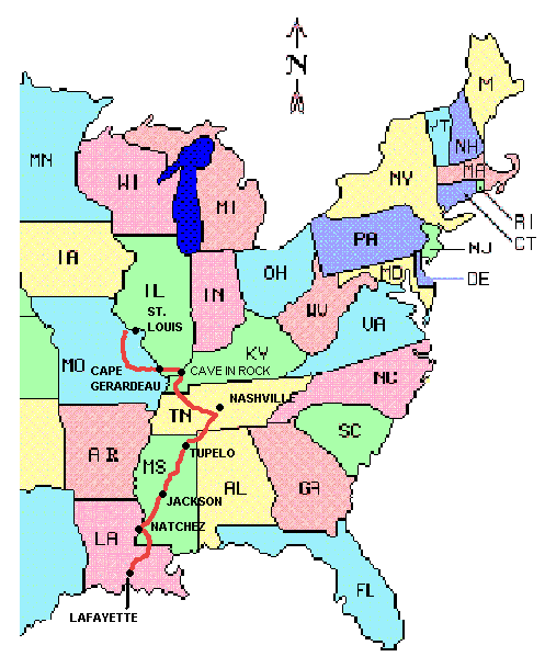
Lafayette, LA to Washington, MO March 31 to May 9, 2003 Start 39,564 miles (63,812 km): End 40,920 miles (65,472 km) cumulative
Teasers:
"It is not a commonplace river, but on the contrary is in all ways
remarkable" The name, "Ol' Man Ribba", evokes images of a wide expanse of rolling, muddy water shimmering brightly under the hot August sun bordered by a seemingly unbroken mass of dense, scraggy forest. Only a smattering of dirty, muddy river towns precariously perched upon the ever shifting river bank, or the occasional logged plantation or harvested woodland serves to break the endless monotony of green leaves and coffee colored water. Insects lay heavily upon the still, summer air driving you to incessant swearing at their shrill, droning - always within hearing but just out of reach of the fly swatter. Youngsters find relief in the calm, cool water at the river's edge while oldsters cast out lines hoping to snag that elusive "one that got away." Rag-tag wooden rafts bearing an assortment of lumber, farm goods, animals, and a motley looking crew of live-aboard family lazily coast down river toward the big city of Nawlins. Chugging upriver comes the majestic steamboat belching forth puffs of greasy, resin smelling smoke from its twin, towering black as coal, smoke stacks. It's a brilliantly gleaming white castle ornately gilded with ginger bread scrollwork railings and brightly painted decorations. It solemnly glides over the river's water headed for towns in all directions along this one dimensional highway of water. Passengers, dressed in their best traveling finery, crowd the many decks to observe those lowly land bound dwellers being sure to let their presence be observed and envied by the same such folk. Here the pilot is king and all others; crew, captain, passengers and yes even the owners, are merely vassals. This is the Mississippi river. "The great Mississippi, the majestic, the magnificent Mississippi, rolling its mile-wide tide along, shining in the sun; the dense forest away on the other side; the "point" above the town, and the "point" below, bounding the river-glimpse and turning it into a sort of sea, and withal a very still and brilliant and lonely one."1. But, this is a Mississippi of an age long past. A time when rafts and river boats jockeyed for position along the over thousands mile S curling length of this busy super highway of water. When the river towns were awash with "rough and hardy men; rude, uneducated, brave, suffering terrific hardships with sailor-like stoicism; heavy drinkers, course frolickers in moral sties like the Natchez-under-the-hill of that day, heavy fighters, reckless fellows, every one, elephantinely jolly, foul-witted, profane, prodigal of their money, bankrupt at the end of the trip, fond of barbaric finery, prodigious braggarts; yet, in the main, honest, trustworthy, faithful to promises and duty, often picturesquely magnanimous."1 A time of Victorian pomp, bravado, and panache. This was the time so fondly recalled by Samuel Clemens. Today is a much quieter time along this river of chocolate. No longer is it the great transportation route of the east, that distinction having been taken over by the railroads and subsequently highways. Only the occasional barge gently guided by attending tug boats and small personal pleasure or commercial tour boats ply its waters. The great days of steamboats are only vaguely recalled through elaborate diesel driven reproduction steamboats built solely for the tourist trade. Otherwise you may stand on the riverbank for hours at a time and see only the flotsam/jetsam silently float by. The Mississippi is truly one of the great rivers of the world. Its drainage basin is second in size to only the Amazon and, if you include its greatest arm the Missouri, is the longest river in the world as well. Considering the vast, fertile lands surrounding it on both sides, it can also be viewed as being the most productive river valley in the world, a fact recognized very early on. Her banks, populated only with small to medium size burgs in Clemens' day, now team with modern metropolitan cities such as New Orleans and Saint Louis. Farms, ranches, historic towns, roads, and highways line both banks. Yet the river remains as unpredictable as even. Evidence of her ever changing character can be seen simply by observing the state boundary between Mississippi and Louisiana. All along the state line are tear drop shaped islands of state property cut off from the rest of the mainland when either the river naturally chose to cut through one of the S bends or the Corps of Engineers chose to straighten the river when building the levees. The river over all is shorter today than it was in Mark Twain's day and it was even longer before then, a fact eloquently observed when he commented;
As recent as a few years ago man's tenuous rein on this mass of water was once again bested when she rose to record heights, flooding acre upon acre of surrounding land and closing bridge upon bridge. Perhaps the nearby residents should return to living as their forefathers in Twain's time did; living, sleeping, cooking, eating upon rafts during high water times returning to their dirt floored cabins only after the water returns to its proper course. In the end the river always wins. It is to this most evocative of southern icons we have come to begin our summer long tour into history. Our true aim is to follow the path of the Lewis and Clark expedition of 1804 to 1806. Yet, what better way to begin than by exploring still further downstream, closer to the mouth of the great river. In 1804, St. Louis was little more than a small frontier town. Flatboats (a homemade raft like structure) were the transportation along the river. Upstream men would build their flatboats, load up their goods, float down to New Orleans or Natchez, sell everything including the boat for lumber, and then hike or horse ride back home along the old Indian trail today known as the Natchez Trace. The great days of the steamboats were still about 20 years off. We began our journey in the city of Lafayette, Louisiana smack in the center of Acadian, better known as Cajun, country. Here is a small region internationally known for its unique cuisine that is an unusual combination of African native vegetables, Mexican chili peppers, and French sauces. On a spiciness scale ranging from ho-hum to lip blistering, Cajun cooking seems to exist only in the realm from WOW! on up. Brian was in nirvana as his taste buds tingled in anticipation of such delicacies as jambalaya, gumbo, and etoufee. Even I had to admit the crawfish sandwiches we found in a mini cafe in the tiny town of Morganza were a true delight. Bending down, I snatched up a string of light blue plastic beads. "Perfect." I exclaimed. This would be my memento from Louisiana. Mardis Gras had just happened not more than a few weeks earlier. It seems that not only is the really big show in New Orleans, but each and every small town in this region has their own local party. Marchers in the extravagant parades throw strings of these cheap, gaudy beads to on-lookers. Not all get picked up, Strung all along the roads throughout the Acadian country are these beads, some from years past, most from this year. Seems such a waste. Well, at least I managed to get my little memento along the way. Our daily rides took us through historic old villages, past hundred year old plantation houses, along the Mississippi river levee, through cow pastures, along tree filled swamps, and finally across the river onboard a little 20 car ferry to the town of St. Francisville. The land south and west of the Mississippi from this point is incredibly flat. There's nary a single hill providing relief from the need to constantly pedal just to keep the bike going. This is all sedimentary deposits left by the river over thousands of years as it wended its way back and forth. Geologists say that at one point the river mouth was actually located at Baton Rouge, some 70 miles upstream from where it is today. Needless to say these vast regions of silt deposits make for extremely fertile farmlands today. The water table is so close to the surface that should decide you want to have a pond all you have to do is dig a large hole. Add a few ducks, polliwogs, and fish eggs and you've got yourself a veritable fishing hole. Once on the east side of the river the character of the land and even the communities seems to change dramatically. Large, open fields give way to dense forests of deciduous and pine trees. The land is higher and has undulating, rolling hills. Your day is spent huffing up one low hill for 10 minutes, screaming down the next side in 1 minute, and then repeating that process over and over and over. I'm not sure which is more tiring, these short rolling hills or the constant pedaling along flat lands. Houses are tucked away between the trees appearing hidden until you come
right upon them. You seem to have to pass right through the center of a town in
order to know it even exists as it's hidden from view by a dense mask of
foliage. Some of the older houses present the picture perfect southern post
card. Large, square and squat houses sporting enormous front porches having the
ever present arrangement of lazy days rocking chairs are backed away from the
road upon what seems to us as absolutely enormous lots. Here's a region where
rocking chairs actually get used. In the early evenings neighbors sit outside,
holding court as nobility of old, hailing each and every passerby. Many of the
yards are meticulously maintained with expansive neatly mowed lawns bordered
with big, bright azalea bushes all ablaze in showy pink, purple and white
flowers.
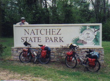
Our ride took us to the town of Natchez just at the most southern extreme of the Natchez Trace National Scenic Parkway. Once partly known as Natchez under-the-hill, this particular town was a vital and colorful part of the steamboat era. In the 1820s Natchez was home to half the millionaires in the entire country. Many of these rich dudes found their wealth through various means involving the Mississippi transportation industry, including piracy. Cotton also played a major role. The "under the hill" portion of the name comes from caves dug into the steep river bank where all the ill-gotten booty was stashed. Not to mention the other shady businesses that plied their trades in that area, brothels being a prominent one. This custom was eventually given up after repeated collapses of the river banks destroyed buildings and buried the bounty. The "under the hill" portion of the town name was also dropped. During the Civil War many high officers of the Federal army turned the many millionaire mansions into their own headquarters and hospitals. Hence, few were burned. Following the Civil war and after the railway essentially replaced most of the steamboat traffic, Natchez's importance declined and it idled away the years as simply a sleepy, small southern village. As a result, many of the Ante-bellum mansions are still standing in nearly original state. Several are open for viewing, for a fee of course, and all can be seen in one hectic showing for a single price during the spring, fall, or Christmas pilgrimage. Seeing as it takes a lot of pedaling and several days to get around to each and every one, we decided not to see any. We'd rather relax out at the Natchez State Park under the spring leaf clad trees enjoying the near perfect spring temperatures and a couple days rest. We'll save the Ante-bellum mansion tour for some other time. Natchez to NashvilleThousands of years before Europeans came to the New World, natives were using a long distance trail leading diagonally across the present states of Mississippi, Alabama, and Tennessee. I suppose even before the Indians came on the scene this trail was probably a rough track followed by animals in their migrations. When white man arrived it had become a major trading path leading between the Choctaw and Chickasaw nations. It was known then as the old southwest trail. White settlers began to move onto the banks of the Mississippi and all its various tributaries. These settlers brought with them farming and logging industries, taking full advantage of the great natural resources gifted upon this region. Getting their goods to market proved to be quite a challenge. Typically they would build large raft-like structures called flatboats. They'd float them downstream laden with the fruits of their summer labors. In either Natchez or New Orleans they sell it all, including the boat. Well, now they had to get back upstream. Hence the use for the trail. These men, and I'm sure a few women, would trek for 5 weeks back north up the 500 mile long trail. Now we're not talking about a nicely maintained, modern hiking trail. Nooo. This was a rough track beaten through the woods and swamps simply by numbers of feet trodding across the land, one after the other. It forced its way through dense forests, mucky swamps, across broad bayous and deep rivers. It could be a rainy, snowy, hot, humid, walk infested with all manner of poisonous snakes and spiders, not so friendly bears and large cats, as well as that ever present, ever irritating mosquito. Yet if natural annoyances weren't enough, you can just imagine what manner of scoundrel might happen to frequent the trail. After all, if some thief could manage to just scare a sum of $30 out of some passing farmer, not even having to resort to injury or murder, and then do that to a good portion of the 1,000 odd people following that very early trail then that'd be a goodly income for those days. Although that's not to say murder wasn't a distinct possibility as well. In 1803, when Thomas Jefferson was president and the Louisiana purchase had been executed, it was decided that this rough trail needed to be improved to become a national road. Troops were sent in with picks, shovels, axes, and saws to hack and hew a path through the woods sufficiently wide for 2 horses to pass side-by-side. Just think, in those days that was considered to be a super highway. Locals as well as the remaining Indians were encouraged to set up supply stands all along the way until there were some 50 spread out along the length. By 1810 the route had become a major thoroughfare handling over 10,000 riverboat men (known as the Kaintucks as most came from Kentucky), as well as supply caravans, mail carriers, and still the ever dangerous highwayman. The year 1812 saw the most profound change come to the Mississippi river valley. It was in this year the steamboat New Orleans chugged its way into the mouth of the river on up into its various channels. Now, given a choice of slogging back up river for weeks across the trail with its ever present dangers, riverboat men had the option of simply booking passage on a boat. Within almost no time traffic along the Natchez Trace slowed to a trickle and then virtually stopped altogether. With the exception of a few local sections, the trace fell into disuse and disrepair, essentially allowed to meld back into the natural surroundings. That is until 1938. In that year the entire Natchez Trace was set aside as a National Scenic Parkway. Work on the Natchez Trace National Scenic Parkway has been on going ever since. In fact, it is only within these next couple of years that the last few sections will finally be completed, a continuation into the town of Natchez proper and a loop around the Jackson, Clinton, Ridgeland metropolitan area. The quality of the road is truly amazing. It's widely paved mostly with a smooth asphalt in the recently rebuilt sections. It's graded, incredibly well graded. While side roads climb up and down each and every short gully, the parkway traverses across the top of big, built-up embankments. Climbs are so gentle you only notice a slight change in effort from up to down. Most climbs seem to occur at bridges, in fact, terrain variations having been removed by the grader. The road is bordered mostly by woods and an occasional farm field. The park service is allowing the bordering fields to return to a wild state. This gives you a sense of what the original trace may have been like, miles and miles of track through unbroken forests. There are picnic tables and rest stops almost every 10 miles and free, mind you FREE, campgrounds that not only have toilets, but flush toilets at that. For bicyclists there is even a bit more benefit, free bicyclist only campgrounds complete with vault or flush toilets and running water. Not only that, park rangers will tend to look the other way if you happen to stop for the night at a picnic area. Bicycling the Natchez Trace is almost as good as the C & O tow path in Maryland, the only difference being the C & O has no motor traffic at all. We entered the Trace at mile marker 10, just outside the Natchez State Park. It was an overcast, somewhat cool day. Mud seemed to be everywhere and several trees were downed. The night before had seen one extremely violent spring thunder and lightning storm pass through the area. Jackson, about 100 miles north, actually experienced 3 separate tornadoes. Brian got out of the storm by retreating to the shower room at the park. Actually he was taking his shower when the storm hit. I attempted to hold everything together at our campsite. Rain poured down in heavy sheets. A good sized waterfall cascaded off the side of our fragile shelter, our tarp strung up like a pup-tent. A small lake formed around the tent. Any attempt to leave the relative safety of the tarp for more than a minute would result in a thorough sopping. The rain beat down like a drum for a good half hour and then quit. That was it, for now at least. Three days later temperatures plunged into the frost levels. Record lows were recorded. We rode all bundled in our fleece and rain gear, shivering whenever we stopped for more than a few minutes. Yet, nature's strange behavior was not yet at an end. Not more than 5 days later, Mississippi was hit with record highs. Virtually overnight fleece jackets were exchanged for shorts and T-shirts. A couple of ladies taking a smoke break outside the Tupelo Wal-Mart commented that it seems there wasn't going to be any spring this year, "Just like there was no fall last year." With the pervious winter having had another "El Nino" we were beginning to wonder if this might be another year where we'd continually hear "This is unusually ______." Fill in the blank with cold, hot, wet, dry, you name it. At least the wild flowers along the Trace believed it was spring. We were treated to an absolutely marvelous display. All along the road edge is a wide strip kept clear of the dense undergrowth and most trees. In it is allowed to grow grasses and a great array of flowering, well I guess they're basically weeds. The road sides were splashed with deep maroon, glorious yellow, brilliant purple and pink, and whites. Bees were having a hay day. Butterflies flitted around appearing to be more controlled by the whims of the wind rather than by any plan of their own making. Even the squirrels seemed to be feeling the joy of spring. Hearing a rustle in the grass, we both glanced back just in time to witness one of these fuzzy little creatures bounding across the field almost as if it were trying to stage a race with us. Ah, spring. Our favorite time of year. Bicyclists from all over come to ride the Trace. Even in these very early
weeks of the traditional riding season we were pleased to see several groups
going both directions. A group of three, loaded with the usual front/rear bags
spent the night in Natchez State Park at the end of their tour. We passed a
sagged group, all getting their photo taken again at the southern end of their
tour. There were two credit card tourists riding recumbants out for a weekend
jaunt from Tupelo to Jackson. Ah, how little you have to carry when you stay in
motels and eat in restaurants. A mother, daughter and 2 son group passed us just
north of the Jeff Busby campground.
Yet perhaps the most interesting was Laurel. Laurel was touring on a bright yellow recumbant trike towing along a small Burley trailer. It's a combination that is just bound to get notice. She went ahead of us after we'd taken a short day. From that point on we kept hearing such comments as, "I've never seen a bike like that in my life." Laurel even told us a great story about the Mississippi State Patrolman who stopped her to give her a thorough scolding. "You're durn right dangerous," he extolled. Laurel told us that the trike is slower going up hills and really not appropriate for rough dirt. It also seems rather heavy, 33 lbs for the bike and probably another 12 for the trailer plus weight for all those other odds and ends adding ounces quickly becoming pounds. But, for a person having knee problems, for whom it's some form of recumbant of no bike riding at all, recumbant bikes or trikes are the best solution. However, we feel that the attention one gets while touring, whether welcome or not, is plenty on just a plain ole bike. We would not be quick to jump onto something so radically different, at least in the common non biker's point of view. It's just not our particular style. Unfortunately, Laurel's knee, a source of much frustration for her both past and present, was not ready for the hills of the northern Trace. So we said our farewells early in the morning just north of Tupelo and headed on. We continued to revel in the exceptional bike riding. Northward we pedaled, through Jackson, past Kosiusko, around Tupelo. In Tupelo we enjoyed the free biker campsite that is located within just a mere mile of great shopping facilities. Apart from Kosiusko, this was to be the only other site along the entire Trace with such readily handy services. We spent 2 great nights in the Tishomingo State Park where 5 miles of hiking took us next to some of the only rock outcroppings to be found anywhere in Mississippi. Another day found us at the very private biker campground at Colbert Ferry, the location where the half Scott, half Chickasaw, George Colbert ran both a stand and ferry across the Tennessee River. Typical Scotsman, he is said to have charged General Jackson $75,000 to ferry his army across the river. The weather became Camelot like, nice in the day, rainy at night. Stores and services, though infrequent on the Trace itself, were plentiful within a couple miles along side roads. Drivers were reasonably tolerant, only an occasional angry sounding honk. Campgrounds abounded, the free ones being our absolute favorites. Truly what more could one ask for. We were not in a big hurry to leave the Trace. When we passed other bikers hauling along at their 60 to 70 mile per day pace we had to wonder if they really understood what a treasure such a route as this is. Once back on the public roads, traffic will again reign. After breaking-in our leg muscles on the flatlands of the southern region,
hills began to really test our endurance as we moved north. They began as low
rollers, gaining height and slope the further north we went.
Toward the north end of the trace lies a site which today is remembered for perhaps one of the most tragic incidents of the early 1800s. Following the completion of their epic journey from St. Louis to the Pacific Ocean and back, Meriwether Lewis was granted govenorship of the entire new Louisiana territories. The bureaucratic lifestyle simply did not sit well with the man, who already suffered with severe bouts of depression. In September 1809 he and a Choctaw guide named Neeley headed from St. Louis toward Washington via a boat on the Mississippi. His objective was to complete the editing of his journals of the "Corps of Discovery" adventures as well as clarify some of the expenditure issues. Evidently he felt he wasn't getting paid sufficiently. Concerned that his notes might wind up in British hands, he left the boat at Natchez and headed overland on the Natchez Trace. On October 9, 1809 Lewis arrived at Grinder's Stand, a little over 100 miles from Nashville. Neeley had delayed a bit down the trail in order to find a missing horse. The innkeeper recalled that Lewis ate little, seemed preoccupied, and talked to himself. Later that night, two shots rang out. Mrs. Grinder, being afraid to leave the house at dark, did not discover Lewis until the next morning. He was clinging to life with a gunshot wound to the head and chest. He finally passed on October 11. Whether he was murdered or committed suicide is still a controversy. He was only 35 years old. Today a large, stone broken shaft monument marks his grave, a symbol of a life violently ended so early. We stopped to pay our respects to one of the men whose journey we are about to emulate. Our last day upon the Natchez Trace was spent leisurely riding a mere 22 miles to the biker only campsite at Shady Grove. We stopped at every pull-out, read every sign, hiked every little nature trail. I suppose we were being a little nostalgic. We were going to miss this pleasant part of our summer journey. Just before we approached our final stop we passed three loaded tourists headed the other way. This was their first day and, for two at least, their first loaded touring experience. They had just a short 8 days to finish what we worked hard to stretch out to 2 weeks. It's when we meet riders like these folks that we really appreciate our full-time traveling lifestyle. Nashville to St. LouisThe ACA route leaves the Natchez Trace about 40 miles before its terminus, which is a 14 miles before Nashville. They appear to have a couple reasons for doing this. First, who the heck wants to ride anywhere near the megalopolis of Nashville anyway. Second, there's another "no commercial traffic" Trace through an area called the Land Between the Lakes National Recreation Area that they've included on their route. The most direct path through some of the most quiet and rural areas necessitates leaving the Natchez Trace before its official end. Perhaps someday we'll come back to finish the Shady Grove to Nashville section, but it wouldn't be a high priority. We've ridden the majority of the Trace and that is more than satisfactory. Roads off of the Natchez Trace Parkway feel like an entirely different world. Gone are the wide swaths of grass and wild flower filled land on either side of the road. Wild looking forests often edge almost right up to the pavement. Or there are houses, stores, restaurants, hotels, parking lots. There's more litter along these roads. No handy-dandy park employee comes around to clean up. Road grades are no longer the easy 6 percent. These country lanes basically follow the contour of the land no matter what the slope. And if there's a choice for the road to go around or over the hill, you know for a fact it's going to go over. Traffic is heavier and faster and there are large trucks to contend with. These are people going about their everyday business, not tourists. In a way, I suppose these rural roads are a bit more interesting than the park-like Natchez Trace. There's always something going on to catch your eye. This is rural, southern America where patriotism shines especially in times of crises. Gulf War Phase II was just successfully completed and the rural folks were not shy about showing their support for the troops. Yellow ribbons and red, white, and blue festooned everything. Ribbons were tied not only to the "old oak tree", they decorated fence posts, porch railings, door knobs and knockers, store fronts, lamp posts, even front grills of semi trucks. Everywhere you turned there were great, big, bushy yellow bows flapping in the breeze. The one attached to my handle bar bag seemed almost puny in comparison. But, at least we did sport one. Exhausting, rolling hills took us over to a place called "Loretta Lynn's Guest Ranch." That's right, Loretta Lynn of coal miner's daughter fame. Now this is quite a set up. There's a large RV park, very nicely equipped complete with pool, play ground for the kids, store, game room, camping cabins, and snack bar. There's also a museum, western town with tourist shops, canoe navigable creek, simulated coal mine, theater where she really does still do concerts in summer, even her 200 year old Ante-bellum house which you can tour, for a fee of course. It's a rather incredible tourist complex all celebrating the life of the famous Loretta Lynn. Not being avid Country Western fans, we chose simply to take advantage of the hot showers and laundry in the campground. Stiff rolling hills took us north from the Loretta Lynn Ranch, through Waverly, past Dover, and on to the Land Between the Lakes (LBL) National Recreation Area. These were three days of exhausting hill climbing punctuated by threatening cloud bursts throughout the day. We got lucky, oh so lucky. The brief 1/2 hour we happened to spend at the LBL visitors center was when the sky broke forth with an impenetrable sheet of rain. Later that afternoon we managed to arrive at the Hilleman Ferry Campground just as the rain once again started to descend and the tornado sirens went off. It was Brian's first tornado warning. I recall going through several while at Purdue. Being indestructible students, or at least we thought we were, we usually ignored them. It was rather stupid on our part as a tornado warning does mean that at least one funnel cloud has been spotted in the area. This particular day Brian and I did not ignore the siren. That's what you do when you're older, wiser, and not quite so immortal. We joined the crowd down at the concrete bathhouse where in impromptu social hour got going. Land Between the Lakes used to be called Land Between the Rivers. There's a point just before joining the Ohio River where the Tennessee and Cumberland rivers parallel each other very, very closely. At one point they are within a mile of each other. Yet the two rivers never conjoined. Rather they each have their own separate junction with the Ohio River. Fairly early on settlers moved into this area. They set up farms and started a whole bunch of small, yet productive iron furnaces. These people were quite isolated from outside influence since only ferries provided access across each river. At one point there was about one ferry spaced every 5 miles or so. By the time the early 1930s rolled around the land was essentially denuded of trees, the furnaces were closed, the bear, deer, bison, bobcat, and other wild animals were gone, and the great depression lay heavy upon the land. It was during the depression that Roosevelt authorized the creation of the Tennessee Valley Authority (TVA). The TVA was established mainly to work on large waterway projects throughout the Mississippi River Basin. One of their projects was to build the Kentucky dam on the Tennessee river and the Barkley dam on the Cumberland river thus creating the Tennessee and Barkley lakes. Along with the lakes, there was a grand scheme to create a huge outdoor recreation area out of the entire Land Between the Rivers region, soon renamed to Land Between the Lakes. The first dam was built in the 1930s and the second in the 1960s. Of course, this meant removing all the populace currently living on these lands. Some didn't mind. Many fought tooth and nail. But the Government's right of eminent domain held fast. Houses were razed or moved, roads allowed to return to nature, and new recreation infrastructure took their places. Facilities and activities in the region are astonishing. There's an entire living history village created from some of the settler's abandoned houses. There's a thriving bison herd started from a seed population of 19 shipped in from South Dakota. There's a brand new visitor's center and planetarium. There's also hiking, mountain biking, swimming, boating, fishing, plus many developed and primitive campgrounds. In 1999 the TVA relinquished authority over the LBL, turning it over to the National Forest Service. Yet even with this change the prices aren't all that high, $3 entrance to the living history museum, bison field, and planetarium show and $12 for the developed campground where there are nice, hot showers and flush toilets. It's easy to see why this area has become such a big tourist draw. Despite the name of this bike route being Great Rivers South, we really hadn't spent all that much time actually riding along rivers. We'd been in the Mississippi drainage basin, to be sure, and we'd crossed several of the great tributaries. But our route generally has been far from the rivers' edges. Finally upon leaving the LBL we were to spend a couple of days along the shores of the Ohio River, sort of. Despite being near the river bank we really couldn't see the river itself. There seemed to always be one more hill between us and the water. I was beginning to wonder about the choice of names for this route. Maybe Tour de South would be more appropriate. We headed upstream some 50 miles to cross at the Cave-in-Rock ferry. Then we head back downstream another 25 miles. It's sort of like riding an out-and-back tour without being on the same roads twice and having a big body of water in between. Once upon a time ferries must have traversed these mighty rivers everywhere. However, since the advent of rapid automobile travel and the building of many major bridges, very few ferries remain. One of the few still crossing the Ohio River is at Cave-in-Rock. Now this is a teeny town bearing a name that is perfectly descriptive. On the north shore of the Ohio river is a sheer cliff into which a deep cave has been etched out by the forces of nature. Now, this particular cave has a rather colorful human history. It seems to have been a hideout for river pirates. One enterprising pirate posted a large sign saying that good liquor and ladies were available inside. Needless to say, once inside neither were to be found. We also heard that they'd place a gun in the cave and use it to force river tolls out of the passing boats. These pirates were so renowned that even Disney produced a Daniel Boone movie about them using the cave itself as their set. We'd met a fellow who'd driven all the way from Metropolis, IL to try out as an extra. The line was so long he simply turned back home. Cave-in-Rock, the town, isn't a whole lot. There's something like 400 people living there. Apart from 2 small cafes, the restaurant and lodge at the state park, a few gift shops, a small theater where local live variety shows are held, a sometimes open bank, and one very large, modern church, there isn't much there. Unfortunately, the grocery store we'd been expecting to find turned out to be 2 miles further down the road. Same goes for the gas station. Since we'd been counting on finding groceries right in town, the ACA map says nothing about the 2 mile gap, we'd brought nothing. Dinner wound up being a simple meal of fried food from the equally simple Dutton's diner. We quietly munched on our fries and chicken and fish while the owner's husband chatted away with virtually every customer who came in. Amazingly he'd been doing exactly that same thing several hours earlier when I'd stopped in to get change for the coke machines out front. His wife and, probably, daughters seemed to do all the work. Hmmm, what a life. From Cave-in-Rock, Il to Lesterville, Mo we followed the same route as the middle tier transcontinental riders. They start in Richmond, Va, cross through the Appalachians, through the Ozarks, across the plains, hitting Pueblo, Co. in the Rockies. They then head north to, you guessed it Missoula, Mt home of Adventure Cycling, and then on west to Oregon. After riding the brief conjoined section, knowing that their route continues west into more of the hilly Ozarks country, and having already ridden the other two transcontinental routes, we've come to the conclusion that the middle transcontinental route is probably the toughest of all three. Why? Well, the northern tier heads across the Cascades and Rockies going across Washington through Montana. From there until around Ohio is pretty flat terrain, relatively speaking, because of the nice scouring job done by the great continental glaciers. It really isn't until New York and the New England states that you hit killer hills again. The southern tier, on the other hand, really only has hills in the Texas hill country, a couple or even just one day mountain work in the Davis mountains also in Texas, a bit more mountain work in New Mexico and Arizona, and the single mountain pass to cross just east of San Diego. At around 3,000 miles it is also the shortest. Apart from winds, lack of water, and an overdose of desert scenery, the southern tier really isn't all that difficult. The middle tier has the Appalachians with their continual up/down climbs, the super tough little hills through the Ozarks, winds in the plains, as well as several good sized mountain passes as you work your way north and then west across the Rockies. It is clearly one tough, tough ride. Yet, this is the route most newbie bike tourists start out on. Equally odd it is just about the only ACA route we have not yet ridden and I'm not so sure we ever will. The day we approach Cape Gerardeau started sunny and warm. But, we'd been warned. Thunder storms were pushing their way across the country packing a powerful burst of rain, wind, and damaging hail. We got up early, skipping morning coffee. There was little to pack, we'd left the bikes loaded and ready to go the night before. We were on the road before 8 AM. There was only about 40 miles to go, surely we could make it before the rains hit. We rode hard. But those ever present steep hills slowed our progress and took a toll on our energy. A 15 minute stop at a Forest Service campground to down a couple of energy bars proved to be a fatal decision. The sky grew darker and darker. Lightning flashed off to the west, again and again. We were not more than 3 miles from the bridge. Even the giant towers of the brand new, still under construction, suspension bridge were within sight. There was perhaps only another 15 minutes more riding to go. But, we were too late. Pulling into a small rest area just outside of town, we eyed the concrete block vaulted toilets with longing. The caretaker, having stopped lawn mowing to wait out the storm, invited us on in. "Feel free to take refuge," he said and we did. In no more than about 2 minutes the skies opened up and it poured. Our little toilet refuge became a tiny island amid a sea of gray, sheeting rain. Lightning flashed around, striking the hills in the distance. In minutes the dry parking lot of the rest area became a little lake making an island of the little green riding lawn mower. We stayed nice and dry. That is until we finally decided to head on. The rain had abated to just a drizzle, a constant, thick drizzle. Yet it didn't look as though it would be stopping anytime soon. So we decided to push on. It really is amazing just how wet you can get in just 4 miles. By the time we got to the bridge we were soaked. Looking at the skinny, old bridge, all those big semi trucks, and that now much harder rain we decided right there and then there was no way we were going to ride across that death trap. As luck would have it, right at that instant at that intersection up pulled a white pick-up truck and the driver was more than willing to give us a lift across. As seems to happen so often in bike touring when you are most in need someone appears out of nowhere to give you a hand. Once across the bridge we checked into a nice, cozy hotel and spent the night tucked in a comfy double bed listening to the thrum of rain on the roof. Now we really know why they invented hotels. Now, according to the maps, the hills were going to get serious. What were those we'd been climbing over for the past week or so, speed bumps? From here until we hit the KATY Trail at the Missouri River we'd be riding through the Ozarks. Misnamed "mountains" the Ozarks really were created from a large plateau that has been eroded by tons of rivers creating steep gullies giving it the appearance of mountains. They really weren't created by the standard mountain building techniques of uplifting or volcanic action. Mountains or not, they still do present a challenging bike ride. It is easy within a 30 mile distance to climb up 250 ft or more 3 to 4 times at grades exceeding 8 to 10%. Which, by the end of a couple of days, makes for some mighty tired leg muscles. With another storm looming in our future, it seems to be an abnormally wet spring, we finally took a rest day at the tiny village of Lesterville. There's not a whole lot to Lesterville, Mo. It's a town of maybe 250 people. Everyone either knows or is related to everyone else. There's one small motel/restaurant, three mini markets, a couple large churches, elementary school, and 5, you count em five, canoe trip outfitters. Evidently canoeing the Black River is a major, major tourist attraction in the summer. We were told that on Memorial day you could expect to find over 10,000 people flocking to the surrounding 20 mile region. When we arrived the town was at an almost standstill. Trailers loaded with 8 canoes each, stacked two per row, stood along the roadway in parking areas in groups of 8 to 10. There was the Parks Bluff Canoes, Black River Rats, Riveredge, and Twin Rivers Landing to name a few. They have a super hectic season from Memorial Day through Labor Day and then sit idle the rest of the year. Better make your money fast and furious or you wait till next year. Here's a town where in the off-season the folks just love to jaw around a lot. Get into a conversation with one person and you'll be at it for at least half an hour. They've got time on their hands, there's no big rush. The older folks that is. The teens, well they're just into computers, showing off their wheels, and making mischief. Even in a town such as this where summer time employment is a snap to be had, the employers still have trouble finding willing hands. One of the float trip operators told us, "They just aren't willing to do manual labor anymore. It's hard work lifting those canoes onto the trailers. And there's lots of weed whacking to be done. Always weed whacking. Nobody wants to do it anymore. The kids just want to sit home and play on their computers." Quite a change from when I was growing up. When I turned 12 it was babysitting. Sixteen meant part time waitress, kitchen help, maid work to save for college books, spending money, and flying lessons. I have to wonder if these kids who nowadays get so much with so little, if any, effort will ever really appreciate what they have. It shall be interesting to see what the next generation will do once out on their own. Hills, dogs, and trashy trailers seem to be the norm for our tour through the Ozarks. Hills: these are tough, tough hills, They're short, steep, and constant. No sooner do you finally reach the top of one than you have to scream down to a river crossing and start the long climb back up. A few days of such riding is fine. Day after day for two or more weeks straight gets to be awfully darn tiring. Dogs: Missouri's Ozarks has to have the most number of free roaming dogs than any state we'd been through so far. Each and every house has not just one pesky mutt. They have to have a whole herd of 3, 4, or 5 and of course they all seem to think chasing passing bicyclists is the most important thing to do. Although Brian did come up with one defensive strategy that actually seems to work. He points his finger straight down the offending mutt's snout and yells at the top of his lungs, "STOP IT." The look of confusion on that dastardly dog's face is priceless. On the one hand its instinct cries out to chase that moving bike. Yet there's this loud, masculine voice yelling at it to stop, just like its master's voice always yells when it's doing something wrong. This really does work. We actually witnessed one dog come to a screeching halt while a second careened right into its rear end. I couldn't help but snigger at the justice of it all. Trashy trailers: The term "trailer trash" has got to come from the Ozarks. We were absolutely astounded at the number of pseudo mobile homes stuck out on large wooded lots that were literally just heaps of trash dumps. These crummy looking trailers, they never do look nice even from the day they're made, are surrounded by the most bizarre collection of junk. Absolutely everything imaginable can be found in these lots, everything from household products produced over the past 25 years or more to an assortment of junker cars, at least one from each of the past 4 decades. We've seen these trashy places before, usually a rare occurrence. But here in the Ozarks they seem more the norm than aberration. What we simply cannot understand is why in the world would anyone keep all this junk. Why not get rid of it? Why not donate those old cars to those charities that'll take anything, running or not? Why not give stuff to the Salvation Army? Why not take stuff to the dump? Why in the world would anyone want to collect this junk just to let it fester and rot under their very noses? I once read a si-fi story having an odd justification for these front yard collections. The theory was that all these folks belonged to some alien race trapped on Earth for many generations. These junkyards they've built are actually some sort of communication network they're using to send a major "SOS, come take us home" message. So maybe someday these houses, junkyards, people, and all their miserable dogs will be "beamed up" never to be seen on Earth again. Then again, maybe they're just junk-aholics. Springtime in the heartland can be a time of extreme and severe weather. I seem to recall a saying that went something like, "The year no buttercups bloom is the year there'll be no tornadoes." Of course buttercups bloom every year, never fail. This year has to be one of the worst. Camped by the Black River in the town of Lesterville we listened to the radio as tornado watches, warnings, and severe weather warnings were issued for county after county surrounding our location. We went to bed on edge hoping the storms would pass us by. Early in the morning I woke to the sound of thunder and lightning off in the distance. But this storm happened to pass to the north, leaving our area calm. However, just before dawn black clouds and a wall of wind came rushing down upon us. I struggled to get pants on and get out of the tent. I couldn't get out on my side, the windward side. Unzipping the door caused the tent to loose structural integrity and the wind flattened it. Only by holding the poles up while crawling out did I manage to escape. By that time the rain was coming down in sheets and I got good and soaked just running to the bathroom. Within half an hour the clouds had passed, the sun came out, and the roads started to dry. By the afternoon almost all evidence of the passing storm was gone. Our tent, tarp, and bikes all survived. This wasn't to be our tornado, yet. On a T shaped ridge about 7 miles southwest of the town of Desoto, Missouri sits the wooded Washington State Park. The campground sits right at the center of the T with the tent sites extending down the leg, the RV sites off on one arm, and the large, block bathhouse in the center. We'd had a pleasant, sunny ride to the town of Potosi where we decided to take a short detour from the ACA route so we could stay in this park and have a short riding day. By about 5 PM we'd set up our tent, had our tarp tightly strung out over the table, the table cover was out and our cooking utensils ready for dinner. It looked to be a nice evening, but all that was about to change. Ruth and Walt, the campground hosts, had just arrived on the first of the month. They were still getting settled into their new summer position, their awning was set up, a couple wooden flowers decorated the site, even a little mailbox marked their site. When we went to visit, though, they were rushing to put everything away. "We're due to have severe weather in about an hour." Ruth informed us. Bustling us inside she showed us the weather newscast ongoing on their TV. The weather lady was sweeping her had over a series of ominous looking red marks showing the current position of storm cells. She then swept her hand down along an arrow pointing directly at us. We were about to be hit. We hustled back to our site and rushed to put everything away. All the dishes, pots and pans went back on the bikes leaving the table bare. Inside the tent we stowed the sleeping bags and clothes in our canoe bags. Everything else went up in the gear loft, on the bikes, or with us. We added the fly guys to the tent, double checked the lines on the tarp, and pounded the stakes in just a little bit more. We were as ready as we could possibly be. Within minutes we got word from Ruth that tornadoes had been spotted in Crawford county, just a stone's throw away, and the superintendent strongly suggested we head for the bathhouse. It was a little group that collected in the secure laundry room. The campground hosts, two other tenters, and us. The folks in the second RV had taken their truck and high-tailed it for Desoto where they hoped to find a car wash to take refuge in. Golf ball size hail had been reported in some of the counties and they were determined not to have their truck damaged. Everyone stood out on the porch for a while watching the darkening sky, everyone hoping the worst would pass us by. Ever so quickly the sky turned a puke shade of green. One of the other tenters said, "We're in trouble." We all retired to the back of the laundry room and within minutes the sky let loose. Never have I seen a storm like it. Wind and rain blasted the sides of the building with unbelievable force. Unequal pressures caused the door to swing open, allowing sprays of rain and billboard papers to fly in. We all stayed closeted in for over an hour, listening to updates on the emergency broadcast system and only peaking outside once in a while. What we saw did not look pretty. By about 9 PM the winds had abated, the rains slowed to a drizzle. Finally we
ventured out. The campground host returned to announce his truck was covered by
a downed tree. The other tenters found 2 trees blocking the way to their tent
site and their tent completely flattened. We headed down the road to our site.
With only the pale light from our little head lamps we picked our way across the
muddy ground strewn with leaves and branches. Gingerly we stepped over five
separate trees blocking the previously clear street. Finally finding our site.
we were dismayed, although not surprised, to find the tarp completely shredded.
In just one 2 hour storm the entire character of Washington State Park was forever changed. The entire T shaped ridge had been hit, hard. Hundreds of trees were either snapped off at their bases, had missing limbs or were uprooted completely. From the bathhouse you couldn't walk more than a few hundred feet without encountering your first downed tree. Climb over that and within just a few more feet there was another. Former campsites were covered in downed trees. Some picnic tables were smashed. Yet, amazingly, the 2 vaulted and 2 flush toilet buildings were completely untouched. Re-inspecting our little tent, we discovered a tree had fallen within just a few inches of the rain fly. We counted ourselves incredibly lucky. It was a cloudy morning. The six of us milled around for several hours listening for sounds of our rescue. At 11 AM we finally spotted the park superintendent coming up the road. Right behind him came 2 men with chain saws working their way from tree, to tree, to tree, and a tractor clearing the path. As the day wore on all the other campers, including the hosts, left. The campground was essentially unusable. We stayed on, figuring the roads outside the park would be in just as impassible condition. We watched as the crew quickly cut, pushed, lifted, pulled, and cleared all the roads throughout the park. By quitting time you could drive anywhere. Now the real work would have to begin. They had an enormous amount of wood to clear out. The next morning we mounted our bikes and headed out. It was just unbelievable to see the roadway literally lined from one end to the other with fallen and cut trees. Yet as soon as we turned back onto the state road, the devastation practically disappeared. Sure there was a tree down here and there. But, nothing like the park. Were we actually in a tornado? Nobody dared venture out of our little laundry room to find out. So we may never know. Based on the swath of damage left behind, we'd have say it was more than close enough to the real thing for us. Two more days of tough, rolling hills took us to the river side town of Washington. The temperature and humidity had soared to asphalt melting levels. My shirt looked like I had just taken a dunk in hot, salty water. "Get used to it. Summer's just round the corner with so much more of this." we reminded ourselves. Riding so many hills especially in such heat for so many weeks gets to be just too much. We find we get to the point where we simply just can't keep it up anymore. Time for a rest, a more than just one day rest. We pulled our sweaty, stinky bodies into an Enterprise car rental office, got ourselves a nice little economy car complete with air conditioning, and headed off to St. Louis for some easy exploration. After that, on to the Lewis and Clark route. Natchez Trace Route NotesWater along the trace is not as plentiful as you might expect. It is available at only the locations with flush toilet restrooms. Just off the route you will not find a lot of services for obtaining water. It is best to carry a full day's worth just in case. Some of the grocery stores in the smaller towns close on Sundays. In addition, expect all to be closed on such holidays as Easter Sunday. Plan ahead for these days. Grocery stores are not usually right near the trace or near the biker only campgrounds. Often you need to ride at least a mile, sometimes 5 to 7, to get to a descent sized store. It seems that hills going in either direction are about equivalent in height and slope. However, in April we found we had almost continual tailwinds when riding from south to north. Only when storms passed was there a day of headwinds. Wind direction other times of year may be different.
References1. Life on the Mississippi, Mark Twain (S. L. Clemens),1882, Reprinted 1960, Bantam Books, Inc., New York, NY Appendix A - RouteApril 1 - 24 miles Lafayette Route 93 North to Route 182 North to Opelousas
Appendix B - Campsites or hotelsLouisianaApril 1 - Opelousas City Park ($5) MississippiApril 4, 5, 6 - Natchez Trace State Park($13/night) AlabamaApril 19 - Colbert Ferry Bike Campground TennesseeApril 20, 21 - Meriwether Lewis Campground KentuckyApril 25, 26, 27 - Hillman Ferry Campground in LBL ($12/night) IllinoisApril 28 - Cave in Rock State Park ($11) MissouriMay 1 - Town House Inn, Capr Gerardeau, Mo ($37.59) |
|
Copyright © 1995-2011 by Caryl L. Bergeron - Distribution for personal use permitted. Distribution for other uses with written permission.
Acknowledgements
|
 Little bridges crossing babbling brooks found here and there add the
finishing touch. We were really enjoying our tour of modern and antique southern
architecture.
Little bridges crossing babbling brooks found here and there add the
finishing touch. We were really enjoying our tour of modern and antique southern
architecture.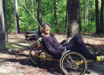 We had to wonder how the two women managed
to convince the two boys to tow the trailer carrying virtually everything while
they only sported handle bar bags and tent pieces. The women were having a great
time. The boys looked tired.
We had to wonder how the two women managed
to convince the two boys to tow the trailer carrying virtually everything while
they only sported handle bar bags and tent pieces. The women were having a great
time. The boys looked tired.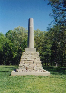 Although despite
the ominous warnings we obtained all along the way, the hills were no where near
as bad as we expected. The parkway has been graded into nice gradual 6 percent
grades which really are no big deal especially when compared to the super steep
hills of western Pennsylvania.
Although despite
the ominous warnings we obtained all along the way, the hills were no where near
as bad as we expected. The parkway has been graded into nice gradual 6 percent
grades which really are no big deal especially when compared to the super steep
hills of western Pennsylvania.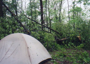 Yet, amazingly the tent still stood. There was water inside, mud all around. It
wasn't ripped. There were no holes. The tent poles were sound. Once again our
little tent pulled through some of the roughest weather. We grabbed most of our
belongings, including bikes, and retired to the men's room for the night. Late
into the night we could hear the sounds of distant chain saws working to clear
the surrounding roads.
Yet, amazingly the tent still stood. There was water inside, mud all around. It
wasn't ripped. There were no holes. The tent poles were sound. Once again our
little tent pulled through some of the roughest weather. We grabbed most of our
belongings, including bikes, and retired to the men's room for the night. Late
into the night we could hear the sounds of distant chain saws working to clear
the surrounding roads.