| Caryl and Brian's World Bike Tour |
|
Great Rivers South - 2003 Tour Part II |
![]()
![]()
![]()
![]()
|
|
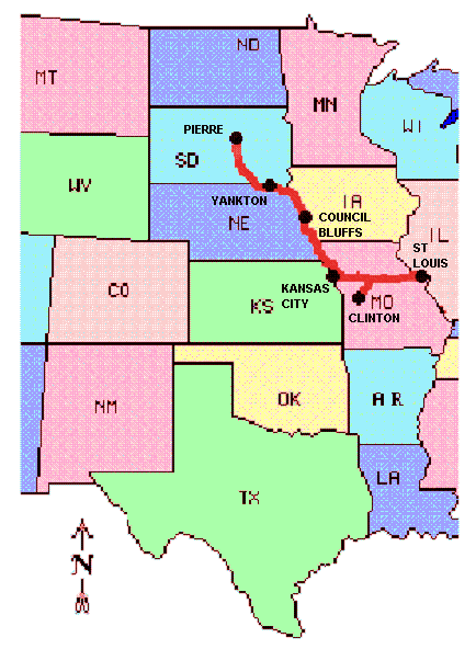
LEWIS AND CLARK ROUTE 1 - 2003 TOUR PART II St. Charles, MO to Pierre, SD May 12 to June 22, 2003 Start 40,920 miles (65,472 km): End 42,262 miles (68,165 km) cumulative
Teasers:
"The object of your mission is to explore the Missouri river, & such principal stream of it, as, by it's course & communication with the waters of the Pacific Ocean, may offer the most direct & practicable water communication across this continent, for the purposes of commerce."1
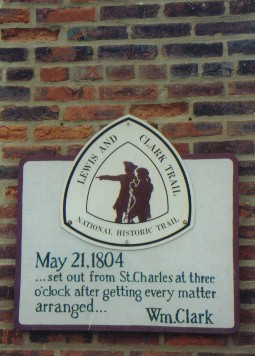
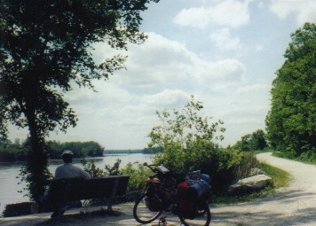
"May 29th. Tuesday - Rained last night, Cloudy morning" William Clark, 1804 On May 21st. 1804 Captains Lewis and Clark along with a retinue of 43 military and nonmilitary personnel, plus one dog, left the small town of St. Charles aboard one large keel boat and two small pirogues, one painted red, the other white. They set sail under the watchful eye of some of the local residents as commented by Clark, "Set out at half passed three o'clock under three Cheers from the gentlemen on the bank." We, on the other hand, left St. Charles a bit earlier in the day a little less than 199 years later with no fanfare, no three cheers. Yet, I am sure we felt much the same exhilaration and excitement the Corps of Discovery must have felt. Each bend in our path to the future would bring about something new and different. St. Charles of the Corps' year was said to be inhabited by about 450 poor, but hospitable folks living in a hodgepodge of similar style structures stretched along a 1 mile length of road adjacent to the river. Oh how that has changed. Thanks to major renovation projects started back in the 1960s it is definitely no longer a poor town. Main street is lined with high end curio shops set in the renovated 1800s brick buildings, each bearing the usual tourist kitsch at tourist prices. Museums, fancy restaurants, a couple of wineries, and some B&Bs fill out this tourist site making it a favorite destination. Many trees line the brick sidewalks and flowers grace the sides of the immaculately well kept buildings. If it weren't for the 21st century autos sitting on the paved street one could almost imagine being back in the 1880s. St. Charles was founded in 1769 by a Frenchman under a Spanish land grant. Eventually the land was returned to France under the secret Treaty of San Ildefenso and consequently sold to the U.S. in 1803 by Napoleon who needed cold hard cash to fight his war of expansion in Europe. The Louisiana purchase secured by Jefferson has to be one of the most profitable land deals ever, perhaps only second to the Alaska purchase from Russia. For a mere $15,000,000 the US bought not only the city of New Orleans, their original objective, they got all of France's territory west of the Mississippi, a 838,000 square miles of land representing all the drainage basin for the Missouri and Mississippi. This effectively doubled the size of the fledgling U.S. On March 9, 1803 this land was ceded to France and on March 10 it came under the U.S. flag. Missouri became a full fledge state in 1821, but not without a lot of fighting and compromise. Before then the Union was equally divided with 11 slave and 11 nonslave states. When it was proposed that Maine be allowed in as a nonslave state, the slave states, in turn, wanted Missouri to come in as a slave state. Debates went around in circles until they came up with something called the Missouri Compromise which said that basically Missouri could be a slave state as long as the rights of U.S. citizens were upheld. I suppose that makes sense only to the lawyers of that day. So Missouri needed a state capital. They chose a site along the Missouri river about halfway across the state and named their future city Jefferson City. While it was under construction they needed a temporary location to meet. St. Charles made them an offer just too good to refuse, free facilities. So from 1821 until 1826 the state government met in a set of rooms upstairs in one of the shops along Main Street. That building has been excavated, renovated, outfitted with period furnishings, and reopened as a museum. In the early 1800s the backs of the Main Street buildings bordered against the banks of the great Missouri river. However, with the construction of the MKT railway in the 1870s, the riverbank was extended many hundreds of feet further south giving room for rails, the depot, and an entire railway switching yard. Today the depot remains, fully restored to its 1880s condition. The switching yard is a wide grassy park complete with a depot style bandstand and the tracks have been replaced with the internationally famous KATY trail. Uphill from the park and Old Town is a city boasting a population in the tens of thousands. It has all the modern amenities the traveler could want, hotels, restaurants, shops. It's hard to imagine those days of 1804 when the town wasn't much more than a scruffy set of small wooden shacks. We began our westward journey of discovery pedaling easily along the famous KATY trail. At 225 miles length, the KATY trail is the longest rail/trail conversion in the U.S. that is completed. The 321 mile long Cowboy Trail in Nebraska is not yet finished and is subject to the whims of Nebraska's budget priorities. The KATY lays on the bed of the former Missouri, Kansas, Texas railway (MKT) which originally extended from the small town of Machen, Missouri through Missouri, Kansas, Oklahoma, to Galveston, Texas on the Gulf. It had multiple short spurs including one into Kansas City and another to San Antonio. We're not sure why Oklahoma got left out of it's name. We were told that during one of it's many reorganizations the "O" simply got left out. Later even the "M" got dropped as its nickname shortened to KATY. It was built in the 1870s and 1880s. The first passenger train rolled into Clinton, MO on May 1, 1870. According to one of the KATY volunteer trail watch members, there were actually two companies competing to finish this particular line. Evidently the Cherokee in Oklahoma decided that only the first company reaching their lands would gain the right-of-way to proceed to the Gulf. The competing company reached Oklahoma one day before the MKT. But, due to a surveying error, they wound up in Choctaw land, missing the Cherokee land by one mile. MKT caught up the next day and won the competition. I'll bet that surveyor was looking for a new job very shortly there after. As with many rail services, the MKT did not survive the advent of auto travel. Passenger service was discontinued in 1958. In 1985 due to competition with trucking and other rail companies, the MKT was merged with the Union Pacific and the section from Clinton to Machen was decommissioned. Recognizing a golden opportunity to create a long distance multi-use trail, many foresighted citizens lobbied and raised funds to convert the rail bed into a rail/trail. Ted Jones, founder of the Edward Jones financial service providers, contributed a whopping $2.2 million alone.
It's an absolutely fabulous trail having a good, gravel surface, good supplies, and great scenery. It follows the Missouri river for about 150 miles from St. Charles to Boonville. Here you'll often find yourself riding with the river on one shoulder and a steep, limestone cliff on the other. If you take a little walk off into the woods away from the trail, you can often find spots along the river where there is absolutely no sign of human habitation. It is at these vantage points you can really understand just what the Lewis and Clark team had to struggle through to make their way upstream. From Boonville the KATY trail heads southwest across rolling farm lands to Clinton. In this section the state park service is trying to return sections of the trail to a presettlement condition, prairie grasslands. Part of their objective is to increase the population of prairie chickens roaming in the fields. It's a great trail. Our only wish was that it had more established camping along the river section. Evelyn and Robert run a small campground in the former river town of Wilton about half way along the KATY trail. It's a shady, grassy campground surrounded by tall herbal plants. It has several teepees and a small cabin all located right next to the trail. The grass grows tall giving it the appearance that it may not be open. We cruised on up and looked skeptically. No shower, we thought. But, as we continued on by we noticed the sign painted on the cabin that said they had cold sodas, beer, cabins, and SHOWERS, that being the key word for us. We cruised on in to see if it really was open. We were greeted by a tall, extremely thin woman dressed in baggy tan pants and a loose maroon short sleeve shirt. Her black, salt and pepper graying hair was secured at the nape of her neck. She had a small face and a little button nose. Her eyes were a pale gray color. She confirmed what the sign said, yes they had showers and they were even hot. She ushered us on into the tiny shop/house across from the small campground to take care of the paperwork. The little store was filled with all sorts of craft type items for sale; pottery, beaded jewelry, dream catchers, etc. Evelyn makes most these objects in her equally small workroom behind the store. We got to talking about these annoying heat rashes I get on my feet. We were soon joined by her husband Robert, a small man with long, pure gray hair. It turns out that Evelyn is Cherokee and Robert is Osage, both originally from Oklahoma, and both very much into herbal medicine. We were soon into an animated discussion of all sorts of remedies that might make a reasonable cure and maybe even prevention for these rashes. Some sounded quite soothing, a pasty tea made from comfry left to soak on the skin for an hour or so in the evening. Some sounded a bit more odd, beaver tail cactus leaf pulp mixed with buffalo fat made into a salve or the juice of a fresh onion rubbed on the skin. I did try the jewel weed, a local plant usually found growing with poison ivy, and found its soothing effect helped clear the rash far faster and better than any cream recommended by dermatologists to date. Perhaps this was a fortuitous stop as we decided right then that I needed to do more research into some herbal remedies for this rash. They may hold the best solution. As the sun was setting over the adjacent, freshly plowed field we listened to flute music and mystical chanting emanating from the little store/house. I am convinced that Robert is more than just a little campground owner. I bet he's a wizened medicine man as well. On their journey, Lewis and Clark spent a good portion of their westerly travels headed upstream against the Missouri river current. It might be nice to picture them leisurely paddling their boats up the quiet river, but that would be quite naive. The muddy Missouri had a pretty strong current even before being "tamed". It was strong enough that being caught up in it could potentially be quite dangerous. Attempting to paddle upriver could be a nearly impossible, task. Their boats did have sails which were helpful on the rare occasions when the winds were favorable. But, we understand much of their time was spent paddling, poling or pulling the boat up river. Men would stand on the gunwales with long poles walking from fore to aft, pushing the poles against the silty river bottom. Other men would slog through the soft mud near shore, ropes slung over their backs, pulling. It seems as though it was tough, back breaking labor producing only a little gain for each day. June 4, two weeks, saw them just outside today's city of Boonville, a distance of under 150 miles which we rode in just 4 days.
While most men, including the captains at times, manipulated the boats, the skilled hunters would spend the day ashore hunting for the evening's meal. They'd bushwhack their way through dense underbrush, swim across streams, and pick off game whenever possible. Later in the evening they'd meet up with the boats, clean, cook, and jerk the meat and do it all over again the next day. With all this super tough outdoor work to do it's easy to see why they selected stout, young military men, boat men, and fur traders all with such experience already at hand. The men expended so much energy that they each ate about 9 pounds of meat each day to maintain their strength. With all this tough work there was bound to be a few discipline problems at the start. One man got caught sleeping on guard duty. His punishment was 100 lashes meted out over a 4 day period. One night two men, also on guard duty, broke into the barrel of whiskey. Now this really was a serious offense as this would be the only whiskey the corps would see until they returned to St. Louis. Drinking an unauthorized amount now took away from everyone else's share later. Punishment again was a good lashing. There were two deserters. La Liberte, one of the French boatmen, disappeared completely and was not recovered. A Private M.B. Reed was recovered by the Mahars (Omaha) Indians. He was court martialed and sentenced to the "Gauntlet four times through the Party & that each man with 9 Swichies should punish him" He was ostracized from the party, treated like an outcast through the entire next winter while at the Mandan Camp, and then sent back to St. Louis in disgrace. Otherwise it seems the strict adherence to military discipline did result in relatively few troublemakers and accounted for the vast success of the endeavor. Among the crew, Lewis and Clark selected men having a wide variety of skills. There were hunters, boatmen, carpenters, tailors, and blacksmiths, for example. Yet we can still think of one additional tradesman we wish they had taken, an artist as in the likes of George Catlin a renowned painter of the native Americans of a few decades later. Lewis and Clark saw so many of the natives at a time when only a minor amount of European influence had invaded their culture, the horse and gun for instance. They also got to experience and see the great migrating herds of buffalo and other wild herds when they were so unused to humans they were practically tame. They were there during a brief span of time when the western regions were essentially untainted by the European influence. Yet, there was no member among their crew to put it down in paints. By the time an artist, such as George Catlin, did get to these regions, white man's influence was beginning to permeate everything. In fact, even the trade goods Lewis and Clark brought themselves helped to hasten the change. Glass beads quickly replaced porcupine quills thus altering clothing decoration forever. Ah if only they'd had an artist on hand to capture what was before. But, that's looking back with 20-20 hindsight, of course. ACA's Lewis and Clark route leaves the KATY trail at the river town of Boonville. But, the trail itself continues on another 75 miles to the prairie town of Clinton. Just because it is a trail, just because it's free of traffic, just because it's easy riding, we decided to go all the way to Clinton and then ride back. We just kept thinking, "how many trails like this are there in the U.S. of this length." We can think of very few; the 180 mile C&O tow path, another 110 mile trail through the Black Hills of South Dakota, the 70 mile Wabash Trail in Iowa, the 225 mile KATY, and hopefully someday the 321 mile Cowboy Trail. After dealing with cars, trucks, and dogs for so long we were enjoying the relative quiet far too much to have it end early. So we rode on down to Clinton and then rode back up to Pilot Grove, about 15 miles southwest of Boonville. Here we said our farewells to the wonderful KATY trail. June 9, 1803 L&C passed a high bluff called Arrow Rock. It's said it received that name because the local Indians made arrow heads from the flint embedded in the bluff walls. It was a name that existed long before their arrival on the scene, dating all the way back to the very first explorers on the Missouri. In later years a small town would be founded on the ledge, first named Philadelphia and then renamed back to Arrow Rock. This was the first stop along the old Santa Fe trail which lead from Franklin, just on the east side of the river from Boonville, to Santa Fe, NM. Arrow Rock would later become a major river stop for steamboats passing up and down the Missouri. In its heyday it boasted a population of 1,000. Good times were not to remain for the town. The bend in the river upon which it sat shifted and it was left high and dry by more than a mile. The fickle Missouri has even shifted course once again in 1993. Former plowed fields along the shoreline are now filling with cottonwood, returning to the state they were in back in 1804. Once river traffic was gone and the Santa Fe trail was no longer in use, the town slowly shrank. Today the sign out by the road claims there's 79 people, but the locals tell us there's more like 50. A lot of the elderly have recently died. The town is all preserved and well cared for, despite its small size. It's home to a lovely state park, the oldest continually operating tavern west of the Mississippi, many B&Bs, a couple small restaurants, and some living history style museums. It also has a theater which is quite active in the summer, drawing actors from all over the country. We chose it as a nice place for a rest day. Why is it when something falls off the bikes you have to be many miles down the road before you notice it gone. Somewhere on the dirt road we'd used as a short cut to Arrow Rock my seat cover fell off. Now it wasn't a matter of it being an overly expensive seat cover. In fact, its price was quite reasonable. It's just that finding another waterproof seat cover of similar quality out in the middle of the prairies would be extremely difficult. So on our supposed day of rest we mounted the bikes and headed back down that dirt road searching all the way. Of course it wouldn't happen to be sitting nicely right at the intersection where we first noticed it missing. It wouldn't even be back at the next intersection. No. It had to be sitting right back at the beginning of the dirt road cut-off, some 7 1/2 miles back. Yup, on our day off we wound up spending about 2 hours riding 15 miles back and forth just to retrieve a $10 piece of equipment. Is that dedication or what? June 10, 1804, "I walked out three miles, found the prarie composed of good Land and plenty of water roleing & interspursed with points of timber land. Those Praries are not like those, or a number of those E. of the Mississippi void of every thing except grass, they abound with Hasel Grapes & a wild plumb of a Superior quallity, Called the Osages Plumb", Wm. Clark. Just west of the large town of Marshall we hit the state route 20. Now we knew for a fact we'd hit the prairies. Here was a long straight road undulating over rolling hills off to the horizon without an end in sight. There may still be wild hazel and osage plum bushes but these would now be relegated to the boundaries that distinguish one field from another. Much of the land is now covered with large open fields in various states of planting, major crops seeming to be corn, wheat, and hay. Jefferson had envisioned Missouri as a region of open fertile farm fields and that's exactly what it has become. The roads are quiet, at least the back roads we were riding, and the towns pretty tiny. We were back in the land where each town no matter how small has its little town park right near the center complete with picnic tables, shelters, toilets, and playground equipment. This is where we can use our "town park gauge". You can always tell a nice, safe town by how well they take care of their town park. If it's in disrepair, beware. We pulled into the town of Higginsville looking for the Fairgrounds park for camping. Outside a large, white house stood a tall, thin old man, paint brush in hand. We got to talking and before too long he was telling us stories about his days in the service in the Aleutian islands during W.W.II. Now here was a rare man. There aren't too many W.W.II veterans left and many aren't out there still painting their own houses. He also told us about his last mission to Europe, on a ship delivering 650 mules to Italy. Imagine spending weeks on a ship during a transoceanic trip with 650 stinky, braying mules. No thanks. Fortunately for him within just a few days of his arrival the peace treaty was signed and the war was over. He didn't have to spend days and days in some mucky old trench after all. It's fun, going through these Midwest small towns. Here is where people still have the time and gumption to chat. It seems too many places the people will hardly even give you the time of day, much less talk for a while. I guess that's what makes travel in the Midwest special. "the low or overflown points or bottom land, of the groth of cotton & willow, the 2nd. or high bottom of rich furtile soile of the groth of Cotton, Walnut, Som ash, Hackberry, Mulberry, Lynn & Sycamore. the third or high Lands rises gradually from the 2nd. bottom (except whin it Coms to the river then from the river) about 80 or 100 foot roleing back Supplied with water (the small rivers of which loses themselves in the bottom land) and are covered with a variety of timber Such as Oake of different Kinds blue ash, Walnut &c. &c." Wm. Clark, June 21, 1804 Today these lands bordering on the river that Capt. Clark described as being so full of trees of various types are mostly covered with plowed fields. Even the first bottom lands, right next to the river, are used for farms. As we flew across the old, downward sloping bridge at the town of Lexington, NE we could see the rich, dark brown soil recently tilled and ready for its first planting of the season. The continual wanderings of the river has dropped silt upon this former river bank for thousands of years leaving extremely fertile soil behind. In fact Clark's description of the river water is probably as accurate today as it was in 1804; "half a common Wine glass of ooze or mud to every pint." However, since the time the dams have been in place, the periodic flooding and river meandering have mostly been stopped which does impact the fertility of these bottom lands. I suppose nowadays fertilizers are used to return what nature used to drop automatically. Although, should the farmers leave the bottoms nature will quickly regain what it has lost, as evidenced by the profusion of cottonwood trees returning to the Arrow Rock region river bank. The holiday weekend was upon us. The one time we really worry about finding camping sites is during each of the three summertime holidays, Memorial Day, Fourth of July, and Labor Day. Campgrounds all across the U.S. fill to bursting with families trying to get as much out of their 3 days off as possible. We really had tried to time our riding to avoid the Watkins Mill State Park on this weekend. We spent an extra day at the Higginsville city park, but the arrival of all those cows for their annual Memorial Day Stock Show gave us a good incentive to go. We aimed for a private RV park located near the railroad which proved to be one of those places better left alone. So now what. Our options at this point were to try to find a wild campsite or head on to the Watkins Mill State Park. We decided to gamble and head on. After over 64 miles of more up/down riding we finally made it to the park. It's a 3 mile long park with the Watkins woolen mill historic site at the northern end, a large lake in the middle, and the campground at the extreme southern end. Naturally we came in at the northern end and at the end of such a long day that the last 3 miles seemed to take forever. At a brief stop to view the park map Brian exclaimed, "I don't care whether they're full or not, I'm camping here somewhere." We continued up one more little climb and crept slowly toward the campground entrance booth. To the right stood a little sign, "Campground" on the top line, "vacancy" on the second. "Yeah!" we yelled. We rolled on in and to our great delight found four of the friendliest campground hosts we'd found in ages. Not only did they quickly check for and hold a site for us, they also told us that even if they'd been full they'd have found a spot for us. They gave us cold sodas, ice for our Koolade, and even gave us a lift the 5 miles into town the next day to buy more groceries. Just another case of when we're most in need we get taken care of. Watkins Mill State park is home to one of the more interesting 19th century mills. This is an old woolen mill. What makes it so unique is that it still retains all of its original machinery, the only 19th century woolen mill in the U.S. to have such. Granted they no longer function. But they literally look as though the employees walked out of the door at quitting time and would return the next day. It was a steam powered mill using a wood fired stove. Inside there are machines that wash, cord, spin, dye, weave, shrink, and press the wool. Wool products sold by the Watkins ranged from yarn all the way to finely woven material. Of course, the woolen mill wasn't the only business going on here. There was a corn and flour mill, plus a variety of fresh and dried fruits and vegetables as well as cattle products for sale. The Watkins family was into a huge variety of businesses which made them so successful. Unfortunately competition from the lower priced and more efficient mills in the east eventually put the woolen mill out of business. Yet we are so lucky today that the machines even exist. During W.W.II. most old, out of business mills were salvaged for their metal. Harry S. Truman, then senator from Iowa, got congress to pass a bill that exempted the Watkins Mill from this fate. Giving up its metals for the war effort would probably not have made any difference to the war's outcome and it sure is nice these incredible works of 19th century engineering ingenuity are still around. Three days later we finally approached our last few miles in Missouri. We'd entered the state on May 1 and finally were set to leave on May 29. We'd ridden almost as diagonally across the state as you can, from Cape Girardeau to just south of St. Joseph. We've concluded it is a state of contrasts. It is a transition state from an eastern to a plains environment. It is remote, wild, and not just a little backward in the Ozarks, yet quite cosmopolitan near Kansas City and St. Louis. It has great state parks with hosts ranging from extremely friendly to "do-it-by-the-books" types. The roads can be extremely hilly and difficult, yet the KATY trail is a breeze. It's not too often we spend a full month in just one state. So now we can say we really have ridden through Missouri. Evening of May 28th found us at the Lewis and Clark State Park just opposite Atchison, KS. Here where the corps celebrated July 4, 1804 by shooting the cannon on the bow of the boat one time, we spent our final Missouri night. Right on the Kansas banks of the Missouri sits the itty, bitty town of White Cloud. It's a town boasting a population of just barely over 200. It has a post office, used stuff shop, and lots of late 1800s empty buildings all lining the single main street running perpendicular to the river. Yet it actually has a few points that make it noteworthy. It has a newly built lookout sitting on a high bluff just north of town. From here you can see Kansas, Iowa, Missouri, and Nebraska. It also hosts a large flea market twice a year, May and August. Locals told us that during those weekends the streets of this town are crowded with odds and ends of used stuff for sale and shoppers looking for used stuff. But, all this pales compared to White Cloud's main claim to fame. Back in 1913, when he was a wee lad of 10, Wilbur Chapman decided to help the leper colonies in such far off places as India and China. His mother had raised enough to help a total of nine people, but she had had her heart set on helping 10. It took a total of $25 to help each child. The man who had come to present the plight of the lepers at their church gave Wilbur a gift of 3 silver dollars just before leaving on the train. Rather than spending that money on such child's fancies as a baseball glove, he bought a pig, named Pete. The entire town spent the winter helping Wilbur fatten up that pig so it would fetch a high price in spring. It worked. He got his $25. Word got around about this generous act and soon the office staff of the Sunday School Times wanted to do something similar. Since it's nigh impossible raise a live pig in an office building, they settled for a pig shaped bank, named Pete #2, with a slot in the back. Loose change found its way into this slot. By 1938 over 100,000 of these little pig shaped banks had made their way into offices, churches, homes, and schools world wide. Over the decades this has become known as the beginnings of the piggy bank and also as the "squeal heard around the world". In White cloud a small monument commemorates Wilbur and his pig, Pete. It's a rough stone with a simple brass plaque. But, despite the good works of the piggy bank, I was really disappointed with the monument. I really expected to find a big, pig shaped statue of some sort, not some flat ole plaque. Phooey. For some reason the previous few days seemed to be filled with odd coincidences. We stop for lunch in front of a volunteer fire department station. Not a soul in sight. Next thing we know up comes a pick-up truck, blue light flashing on top, siren blaring. Soon the station is abuzz with activity as the ambulance rolls out and the dispatchers stay behind. The very next day we stop at a small, white church for lunch. It was Tuesday and not a soul was in sight. Up rolls a car with the 2 cleaning ladies there for their 1/2 hour cleaning job. The next day we stopped in front of a lot having an old, abandoned house. Wouldn't you know it within minutes up rolls a truck towing a large plastic tank wanting to turn in. In all these cases, any other time, any other day of week and there probably would not have been anyone else around. However, these weren't the most amazing of all. We pulled into White Cloud. Down by the marina, more of just a simple boat ramp, was a small crowd of people. A van bearing the call sign for a local radio station blared out country/western music. Turns out this radio station was celebrating their 25th year of operation. They were traveling from town to town giving away prizes, ice-cream, and cake.
Living in White Cloud is a most unusual man going by the name Wolf River Bob. He's tall and slender. His long hair, pulled into a taught pony tail, changes color from blond to gray at the top. He sports one of those long shaggy gray beards that looks like it hasn't been trimmed since day one. He's one of those kinds whose done everything. He was in the service right at the end of W.W.II, which means he must be nigh on about 80 years old. He was a missile technician out at Vandenburg AFB at one point. But his main claim to fame is in working in old western shows. He did and still does displays with the bull whip and fast gun. It turns out these western shows attracted a whole bunch of characters from the Hollywood scene. Old Bob has made the acquaintance with such famous personalities as Sammy Davis Junior, Jerry Lewis, and of course Roy Rogers and Dale Evans. Now perhaps he's just being a bit of a name dropper, but I have to admit it seems strange to think of Jerry Lewis and Sammy Davis Junior being fast gun fans. About 15 or so years ago Bob moved back to White Cloud to care for his ailing mother. He was so distressed with the state of the town he started investing in the property. He owns his late mother's house, about 15 acres of land above the town that he's turned into a primitive campground, one of the downtown brick buildings that's stuffed full of used things, and another old wooden store building also full of stuff. In fact, Bob, in the interest of saving the town, is the one who started the biannual flea market. But, his main interest these days is in the Lewis and Clark journey. He's been involved with the L&C heritage society since about 1969. He's traveled the trail back and forth, attended all sorts of events, helped with getting the trail signs posted, and basically worked with the organization for years and years. His interest in local history along with his knowledge of Lewis and Clark make him one interesting character to encounter. If we had more time, he'd be someone we could learn quite a bit from. Captain Meriwether Lewis sits on the banks of the Missouri river near the site the corps camped around July 14th, 1804. That's the absolute truth. The side, paddle wheeler, steam, dredge boat named after the illustrious captain that is. It's a beautiful old boat and a fascinating curiosity from an historian's and engineer's stand point. Actually this big beauty is a relatively young steamboat having been built in 1931 and taken out of service only in 1969 after 38 year hard dredging work. During the Great Depression one of the make work projects created by FDR was the Work Projects Administration (WPA). One of the WPA's assignments was to make the Missouri river a more confined and controlled waterway. This effort entailed dredging a single, narrower channel to contain the water which also resulted in a river being some 180 miles shorter. The banks of the river were stabilized using willow reed or flat batten woven mats which were later replaced with rock embankments. A series of dikes and levees were also constructed to make sure the river went where it was supposed to go. The dredging operation consisted of placing two large pylons down in the river bottom upstream. The dredge would then back downstream about 3/4 of a mile. A 40 ft wide, vacuum cleaner like scoop would descend in front to a depth of 20 ft. Loose sand and rocks would be sucked in the scoop, passed through the pump, and ejected out the back through a long series of floating pipes that directed the dirt to where ever they wanted it to go. The dredge would suck up all this dirt while slowly pulling itself forward using large cables attached to those front pylons. Once a section was complete, the pylons would be retrieved, the steam power diverted to the side paddle wheels, and the whole boat moved forward to the next section. A total of 4 boats worked continuously 24 hours a day, 7 days a week for 38 years getting the river modified to the desired shape and depth. It carried a crew of 52 men working 3 shifts. Today the four boats are scattered around. One in Brownville, one in Omaha, one in Cincinnati, and I don't know where the fourth is. The Lewis is not as pretty as some of the old, plush passenger sternwheelers would have been. It was basically a work horse, nothing more. But it is still an interesting boat to visit. Unfortunately we do have to wonder what its future might be. Years ago the state lost interest in its preservation and sold the entire thing to a local foundation for $1. For many years local volunteers kept things going, but many of them are either getting to be quite old or have died. Admission fees don't come close to keeping it in good maintenance much less doing any major repairs. They do get some donations. Recently they got a $24K grant to add a new roof and hope to get another $10K to cover the second floor as well. But, this has been through the efforts of the curator who says, "I'm a farmer not a curator." It does need some fresh blood and fresh interest. But, we just don't know where that might come from. Hopefully interest is there and we're just not seeing it. Anyway, with the soon to be completed Steamboat Trace bicycle/hiking trail and the bicentennial of the Corps of Discovery's journey we can only hope the interest in this old boat dramatically increases.
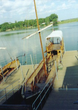
"Some hard Showers of rain this morning prevented our Setting out until 7 oClock," Wm. Clark., July 14, 1804 We'd made it about 4 miles up the Steamboat Trace before the sky darkened and rain started to fall. For once we decided to take a chance and not don the rain gear. For once our gamble paid off. As we furiously pedaled along, we just barely felt the trickle of a few sprinkles, just enough to know we were in a rain storm, but not enough to really get us soaked. We rushed into the little town of Peru, pushed the bikes under the covered picnic area, breathed a sigh of relief glad to know we'd made it, and the rain promptly stopped. It figures. The next morning, on the other hand, we woke to a wretched, drizzling, cold day. It was to be one of those all day, crummy rains that can be so miserable for riding. We simply opted to stay put. After all, the little town of Peru had spent a good sum of money putting in their nice covered picnic area complete with flush toilets. So why not take advantage of it rather than going out to get soaked. We had arrived at Peru just at the end of their weekend long Ole Man River days. Main street was filled with a bunch of those cheaply made carnival rides, all glitz, light, and color, no structure. These were just beginning the long process of breaking down and folding themselves into bizarre looking, mobile sculptures in preparation for moving on to their next location. Mud bog truck racing was still going strong down in the nearby field. Full sized pick-up trucks all roaring with mufflers that sounded likely to fall off at any moment, plied the fields and occasionally made their way onto main street. Globs of mud spewed behind flying into the air to become big dirty projectiles for hapless pedestrians. Fortunately, even the mud trucks soon packed up to go home. By Monday morning, town was back to deep dead quiet. So we were left with a long, wet, cold boring day waiting out the drizzle. By Tuesday morning the rain had finally stopped, but it left behind a very much altered Steamboat Trace. The crushed limestone had turned somewhat mushy. It was just mushy enough to make the bikes feel like someone was grabbing onto the back getting a free ride. It took just that little bit more work to get the same distance that seemed so much easier the day before. It was the crossing farm roads that really were a mess. Originally, when the trace was built, they would have put down the crushed limestone surface all along. Unfortunately, this got in the way of the farmer's road graders which promptly scraped it all up leaving behind only native dirt. We're talking about that deep, sticky clay mud that makes such good soil for growing crops but is so awful for riding a bike. Inches of mud sticks to the wheels, rolls up and then traps on the brake calipers. Eventually it builds to the point where the bike becomes virtually immovable, almost glued in place. The cross roads were short enough we could ride through and then try to scrape mud off after. However, at the end of the trace is a long, 1 1/2 miles of farm road made only of this mud. It was impassible. To every problem there is some sort of solution. Running next to this road of muck was the old, hopefully no longer used, railroad track. Pushing along a railroad track isn't easy. The bike bounces along with a ka-thunk ka-thunk. Gear rattles and bangs. Footing can be tricky over bridges where there are no rocks between the ties, just wide open air. Forget riding. It's tough enough just to push. But it beat getting further covered with layers of mud. We finally arrived in Nebraska City, muddy, tired, and more than ready for long showers for both us and the bikes. It was not fun. The Steamboat Trace is great in dry weather. It's a ride we'd avoid when it's wet. Nebraska City will soon be the proud owners of a new Lewis and Clark center that focuses on the flora and fauna discoveries made during their expedition. In the meantime, one of their key displays is housed in the outlet mall located next to center's future site. It is a full scale replica of the keel boat used by the expedition. The original boat was designed by Lewis and built in Pittsburgh, PA. This reproduction was constructed as a prop for use in the IMAX documentary film produced for the bicentennial. It is 55 ft long and 8 ft wide with a 3 ft draft. It has a raised, sloped quarterdeck in back that provides a small shelter underneath. The aft quarterdeck is covered by a canvas awning and is where the helmsman mans the rudder. The rectangular shaped gunwales along both sides have hinged covers to provide extra storage. The tops of the covers are ribbed with slats and were used as a walkway for the men poling the boat upstream. When flipped up, the gunwale covers were also intended to provide some extra protection in case of Indian attacks, although they were never used as such. The boat had a single, hinged mast with a small square rigged sail. On the bow of the boat is mounted a small cannon. The wood for the reproduction is stained a natural light color and nicely varnished to a high sheen. I assume the original was similar. This would actually be the first of two reproduction keel boats we would see, the second being in the Lewis and Clark State Park in Iowa. It isn't until we actually looked down upon and even climbed into the second boat that the real magnitude of the corps' effort comes to light. This is not a small boat. It is big. It is heavy. We could only imagine just how hard it was to pole and pull this monster fully load with a ton of supplies up the Missouri against a stiff current. You have to admire the men's tenacity. We had a wonderful ride to Council Bluffs. The weather was reasonable, for a change, the winds fairly calm and at our rears, and the distance short. The added icing on the cake was learning that the bike trails within the city have been extended around to the west and north making it far, far easier to get past this city of around 100,000 people. So we rode about half way around the city and then moved ourselves comfortably into the Lake Manawa State park for a couple of days. Way back in '88, when we rode our very first coast-to-coast tour, we recall that bike trails in the middle plains states were very rare indeed. Now we are simply stunned at the number of extremely well planned and built trails there are. For instance, Council Bluffs has almost completed a ring of trails around the city and has plans for two cross city routes in addition to the already existing Wabash trail. Omaha, on the other side of the river, currently boasts over 67 miles of trails and has plans to build many more miles eventually connecting itself with Lincoln. Both cities plan to build a pedestrian bridge spanning the Missouri allowing riders and walkers to get between the two. Further upriver Sioux City has built a few trails following along their rivers and already has a pedestrian passage across an existing bridge. Nebraska is working on the Steamboat Trace and has some sections of the eventual 321 mile long Cowboy Trail completed. This Cowboy Trail hopefully will someday link the town of Norfolk with some town way over on the western edge of the state. And, of course, there's the KATY trail. One tends to think of the coastal regions as being more progressive as far as bicycling is concerned. But, we're beginning to wonder if these Midwestern states aren't fast catching up and surpassing them. We just had to stop in Council Bluffs to visit a couple of their museums. The first was the National Western Historic Trails Center, located nicely right on the newest section of bike trail. It is intended to summarize the Lewis and Clark, Oregon, California, and Mormon trails. A lot of the information it contained can be found in the many other centers devoted to the same subject. However, this one does have a most unusual movie. The movie shows a combination of home videos of a modern day family headed out on a cross country journey in their VW camper along with photos and quotes taken from the pioneers of old. Perhaps the most striking quote from the pioneers was "No water today." being spoken by a woman while the video shows modern travelers filling gallon sized jugs of sodas or carrying 7 pound bags of ice. Oh how we do take those modern conveniences for granted. The other museum we just had to see is the brand new Union Pacific Railroad museum housed in the old Carnegie library building. It's only been open since April 2003, so everything in it is as up-to-date as can be. The new library had vastly outgrown this old 19th century brick building and is now housed in modern structure just around the block. It is nice to see communities with these old Carnegie buildings do find some use for them. Anyway, the Union Pacific museum focuses primarily on the Union Pacific's role in expansion of the railroad across the country, naturally. UP was the rail company given government approval to build the transcontinental line from Council Bluffs headed west. They met up with the west bound Pacific Central construction at Promontory Point, Utah. Once past the usual stuff about the first transcontinental railroad which included information about the surveying and building, the museum focused on the more modern aspects of the railroad. Of particular interest were the upstairs displays which showed such rarely seen things as how modern train traffic control works and how modern track maintenance and reconstruction is performed. It's absolutely amazing. Lifting and re-laying the rails today takes a mere 50 people and some mighty major machines. Compare that to the thousands it took to build the track back in the days of pure hand labor. "Above this high land & on the S.S. passed much falling timber apparently the ravages of a Dreddful harican which had passed oblequely across the river from N.W. to S.E. about twelve months Since, many trees were broken off near the ground the trunks of which were sound and four feet in Diameter." Wm. Clark., July 29, 1804 Weather problems continued to plague us. The day we left Council Bluffs started out fine enough. A line of black clouds crowded the western sky. But, according to the papers and the radio, rain wasn't supposed to begin until the afternoon. "Afternoon thunder showers." was what they were saying. HA! By 11:30 we were in the middle of a constant, hard rain, not just thunder showers. It didn't stop raining until well after dark that evening. Oh, there was an hour or so here and there where it was somewhat dry. For the most part this was simply one long, wet day. By the time we reached Missouri Valley we were soaked to the bone. With chattering teeth and squishing feet, we made our way to the local Burger King restaurant and essentially moved in for the afternoon. As we sat in the warm, dry restaurant watching a steady flow of water from the sky our only thought was how much nicer it is to ride in this kind of weather in populous states. We so well remember our 2 weeks on the Casiar Highway in Canada where we spent soggy day after soggy day with no relief, no warm place in sight. Yes, even a fast food restaurant looks like heaven on this kind of day. We haven't been quite able to determine whether this spring has been unusually wet or not. Certainly that week of record number tornadoes was unusual. But, residents seem divided on the rain. Many tell us this is a highly wet spring. Yet other's say they're still in the midst of a drought. Now, we've seen droughts. A drought in San Diego means it doesn't rain for months and they only get an inch or so the entire year. That's a drought. In Nebraska and Iowa they usually have about 11 inches rain by June and this year they were running only an inch short. If that's a drought, it's got to be the wettest drought we've ever seen. Anyway, even though we'd been enjoying the green hills and tall trees we really were beginning to look forward to dryer, browner places like Pierre, South Dakota. If it's not rain, it's wind. So the day after this all day soaker, the winds howled out of the north. This makes one think long and hard about the vagaries of rain, wind, and bicycle travel. Which is worse? That is the question. Is it less difficult, less uncomfortable, less miserable to ride all day long in a freezing, wet rain with a good tail wind or on a nice sunny day with a roaring headwind. We're still debating this. We do know the ultimate worst day is an all day, freezing rain into a headwind. That's the time to find a hotel for the night, if there is one around that is. Brian broke a spoke. Typically that's not a big deal. Brian breaks spokes all the time. This time, however, proved to be a little bit different. After pulling off the tire, I began stripping off the rim tape to gain access to the spoke nipple. "Whoa. Look at this." I exclaimed. Brian comes over as I continue stripping off more and more tape. Along the inner rim wall running circumferentially from spoke hole to spoke hole was this enormous crack. It extended nearly 180 degrees around the rim. The rim was shot and probably near a complete collapse. We'd been having trouble with both our rear wheels for weeks. I thought the rim flanges had been somehow been bent outward resulting in a bulge that produced extremely sudden braking. Stopping was real fun as I never knew if I'd come to a sudden stop and very nearly get tossed over the handle bars or the wheel would lock and skid along the road surface. I did wind up with a very odd wear spot on my tire from all the skidding. Brian's wheel was also bulging, but not nearly as badly as mine. Visits to bike shops to try bending the rim wall back had been unsuccessful. Since there was no external indications of a problem we figured we could wait until we reached Montana to get new wheels. Had we known this huge crack was the cause of our sidewall bulging we would have elevated wheel replacement to an immediate priority weeks earlier. As it was, our first task for Sioux City was to find new wheels. There were other chores to be done as well, try to get dental appointments, work on moving our Wyoming postal box, and pick up odds and ends of things at the Wal-Mart. Now we could do this on bike, which would probably take many, many days, or we could rent a car and get everything done in just a day or two. So it was off to the Sioux City airport to see what kind of car rentals we could find. Sioux City airport is extremely small. It is serviced by only a couple of airlines, surprisingly the Dutch KLM is included. It has essentially one and only one gate. Passengers still walk across the tarmac to get to the planes. There are only 3 on-site car rental agencies all of which had ridiculous prices. Our best option was to go with an off-site agency. While we were sitting at the "business service" area, essentially a group of phones and phone jacks, working on car reservations, a rather scruffy fellow comes up and asks if we're the ones with the bikes outside. "Yes" we replied. For a couple of weeks we'd been hearing tales of a father, two sons, and one of their friends riding just a day or so in front. Again and again we heard about this group that had just packed up their gear and left that very morning from where we were planning to camp. With all our delaying during the rains we figured they'd probably be far ahead of us by now. Not so. Here in this airport was the father asking if we needed any help. Turns out his sons were in a wedding and had flown back home for the weekend while the father and friend remained behind in Yankton waiting. Once again, we experience one of those strange coincidences that so often happen while bike touring. On to Sioux City. "Serj. Floyd Died with a great deal of Composure, before his death he Said to me, "I am going away" I want you to write me a letter" We buried him on the top of the bluff 1/2 Mile below a Small river to which we Gave his name," Wm. Clark, August 20, 1804 For all the trials, difficulties, and dangers the corps experienced they only lost a single man of the expedition. Even Lewis' Newfoundland dog, Seaman, made it to the Pacific Ocean and back. Clark stated that Floyd died of a "Biliose Chorlick". Biliose meant abdominal and Chorlick meant pain. Kind of obvious I'd say. Lewis' treatment for this malady was a series of blood letting and enemas, both of which likely made matters worse. At one point he stated that Floyd had no pulse, a sign of severe shock which could have well been brought on by all that blood letting. Scientists today believe that Floyd died of a ruptured appendix, a malady which was not recognized and for which there was no cure in their time. In fact, the first appendectomy did not take place until many decades later. So basically there was no hope for poor Sgt. Floyd. On the other hand, Charlie, as the local Lewis and Clark Heritage Foundation representative likes to call him, wound up as more of a legendary and famous person as a result of his early death. He's got a huge, 100 ft, obelisk monument standing over his bones in a location a bit removed from his original burial site, that bluff having been eaten away by the ever changing river. The monument has a commanding view of the river valley and is lit with flood lamps at night. When names from the expedition are mentioned after Lewis and Clark comes York, Lewis' slave, Sacagawea, the Shoshoni woman, Juan Baptiste, the baby, and then Floyd. Just try to name some of the other members. You might be able to come up with Gass, Floyd's replacement and the last known living member of the original corps, Toussaint Charbannou, Sacagawea's husband, and just possibly you could come up with George Shannon, the youngest member of the group who had an unhealthy knack for getting lost. The rest of the names are pretty much forgotten to all but the most avid of history buffs. So perhaps by dying in the middle of such a monumental task Charlie Floyd now has a sort of immortality that he otherwise would not have attained. I wonder, if you could go back in time and tell him that you could remove the appendix so he'd live, but he'd be giving up being famous over 200 years later, would he choose the operation or not? Anyway, he died. His monument sits just south of Sioux City within easy reach of route 75 and there's a fair amount of discussion about him, his malady, and some of the medical aid Lewis had available at the brand new Lewis and Clark Interpretive center down by the river. You can learn about all sorts of aspects of daily life for the explorers at this center as well. It begins with an overview of the different jobs each member had to perform. You get to choose your preferred profession. I selected hunter. The normal privates had to struggle and toil all day long tugging that boat upriver. The hunters got to roam the land, exploring, while looking for game yet they didn't have to keep a journal and they didn't have to be responsible for anything except finding meat. Granted they had to drag all that game back to the boat. But, to me, that sure beats pulling ropes while staring at the muddy water of the Missouri all day long. Yup I'd be a good hunter. I'd sneak up quietly on one of those beautiful elks, look into those big, brown eyes, bring my gun up to shoulder level, and promptly hand it over to someone else to pull the trigger. OK, perhaps I'm not a hunter type. Fishing may be more up my alley. With our chores done and the bikes fixed we rolled on to the town of Vermillion. What a great day for riding. Winds were light or even in our favor for a change. The roads were flat and very lightly traveled. Towns with supplies were plentiful. Best of all, we didn't have far to go. What more could we ask for. The terrain is so flat on this side of the river that a single, conical mound became a significant note of interest for the explorers. Clark notes that it: "is supposed to be the residence of Deavels. that they are in human form with remarkable large heads, and about 18 Inches high, that they are very watchful and are arm'd with Sharp arrows with which they Can Kill at a great distance" Wm. Clark, 23rd. August 1804 They even back tracked several miles the following day with a group of about 9 to go take a closer look. It was a hot, summer day and all were much affected by the lack of water, even the dog. But, this hill, known today as Spirit Mound, did afford a magnificent view of the surrounding area and, despite all the warnings, the party did not encounter any of those hostile little people so feared by the local natives. We decided to stay in Vermillion an extra day not to go see the mound, but rather to see two of their museums. One, the W.H. Over museum, contains a lot of the usual historical artifacts from around the area. Of particular note are the number and quality of items from the area natives back in the 1800s including a complete, original canvass tipi. Even more impressive is a museum having absolutely nothing to do with local history nor with Lewis and Clark. This is the Shrine to Music. This museum has got to have the rarest and most varied collection of musical instruments we've ever seen. It has everything ranging from pianos, harpsichords, guitars, banjos, and an amazing variety of woodwinds to exotic instruments I can't even describe from India, Asia, and Africa. Many of its pieces are ones or twos of a kind, the sister pieces being held in various more famous museums around the world. It has several original Stradavari stringed instruments including one of the few violins in existence. It has a guitar donated by BB King and some of the strangest looking horn instruments we've ever seen. It even has the oldest known European style keyboard instrument in existence. It's a well displayed, well equipped museum with something for everyone even remotely interested in music. What really adds to its value is the audio tour as this not only provides discussion on some of the more unique pieces but it gives example sounds from some of those very rare instruments many of which are extremely unusual looking. And this entire museum is absolutely free. So even though this museum really is not focused on the objective of this particular bike tour, we are so glad we decided to take a look. "here the man who left us with the horses 22 days ago (George Shannon) and has been a head ever since joined us nearly Starved to Death, he had been 12 days without any thing to eate but Grapes & one Rabit, which he Killed by shooting a piece of hard Stick in place of a ball."
"thus a man had like to have starved to death in a land of Plenty for the want of Bullitts or Something to kill his meat." Wm. Clark, September 11, 1804 Poor George Shannon. This little 2 week episode would prove to be just one of many times when he'd find himself lost. There'd be times when he'd be missing for hours and even a few days. So I'll bet by the end of the journey he became the butt of many a teasing. I can see nicknames like "wrong way Shannon" or "shoulda been here but wasn't, Shannon" or "where's Shannon". but, let's give the boy, and I call him that on purpose, some credit. After all, at 18 years of age at the start of the trek he was the youngest and probably least experienced of the entire corps. In addition he was not known as being their best hunter. He did seem to be enthusiastic and loyal. In this particular 2 week stint he'd been hurrying along the bank trying to catch up to the keelboat when, in fact, he was already well ahead. Finally, when he was nearing starvation, he decided to wait on the bank for a trader's boat to take him back downstream. It was not too long after that that the keelboat showed up, much to his relief. This location is now near the town of Pickstown and the Ft. Randall dam. We, fortunately, have a map. We have multiple maps and a tour guide as well. Plus the roads are paved and there are directional signs everywhere. That doesn't mean we don't get headed off in the wrong direction occasionally, however. Just outside of Pickstown we caught ourselves headed east on route 281/18 when we really wanted to be headed north. It was only a half mile and about 5 minutes before we realized our error, certainly not 2 weeks. The curse of the prairies are the winds, always the winds. There's a myth circulating among newbie bike tourists that winds on the plains predominately head west to east. This is pure, one hundred percent, "horse hockey" as the colonel on the old M*A*S*H TV series used to say. There is one and only one definitive statement you can make about the winds. They will come out of whatever direction they choose, period. We try so hard to dispel that old wive's tale, but again and again we hear it. This time from a solo woman bike tourist who was so new to the game she hadn't even heard of Adventure Cycling Association yet. Even after telling her this was our 4th cross country bike trip she still refused to believe us. Yet just a week after meeting her we went through a spell of 4 days when the wind came out of 4 different directions making a full 360 degree turn. Yup, those are the winds we've come to know and love *&^%cough cough*&#. So here's the scoop on the winds. There is no particular predominant direction. Everything depends on current temperatures, position of high and low pressure systems across the continent, location, type and speed of fronts, local geography, even buildings size and position, or whether or not that cow across the road is facing east or west. We can state that usually when near mountains the winds will descend from the cool mountain tops to the hot lowlands on summer days. So wind direction will depend upon your relative position and direction to these mountains. Also, winds on the prairies often have north or south components. They're rarely directly east or west. Local South Dakotans tell us they feel the strong winds usually are out of the south or southeast while weaker winds come from the north. This is confirmed by ACA's statistics as well. Yet we still spent a couple of days in Pierre waiting out purely horrendous winds all from the north. So if you're headed cross country on a bike do not count on continual tailwinds if you're headed east. You will, we guarantee, see winds from every possible direction. So we decided to take a day off in the town of Chamberlain. It has a campground close to town plus two museums of interest, the Akta Lakota Sioux museum and a brand new Lewis and Clark Interpretive center. It was time to do laundry and our legs were demanding rest. Of course, after making this decision the winds naturally would choose to absolutely howl from the southeast. We would have had tailwinds of about 20 to 30 mph. Grrrrr. We've always been unlucky with the winds so I guess this was just keeping in true form. Maybe, just maybe it'll continue howling another day or two. We woke on a fine Saturday morning to a slight breeze from the southeast. "Yes" we thought, "tailwind." This being the prairies, winds that start gentle in the morning usually, almost always, turn into howlers by the afternoon. Today would be no exception. By the time we reached Ft. Thompson, about 25 miles up the road, winds were well up to that 20 to 30 mph zone. Unfortunately this was where we hit a small section of route that headed south, right into those howling winds. We had about 6 miles, uphill to go and we just crawled. Struggling at a mere 3 to 4 mph, all the while downing as much water as we could, we gradually made our way to the top of the hill. Once there, our speed climbed to a marginally better 9 mph. Then we turned. What a difference. I watched as my speedometer climbed past 10, past 12, up to 16. People often find it hard to believe that bicyclists can be so impacted by winds, but when you're out there mile after mile even the slightest breeze for or against you makes a huge difference. Our camp that night, some 61 miles later, was beside one of the extra long lakes that now make up hundreds of miles of the Missouri. There are 6 dams on the Missouri spread out along the length of the river from South Dakota into North Dakota. Each one creates a huge, skinny lake in some cases well over 100 miles in length. The total capacity of the lakes is large enough to contain up to 3 years output from the Missouri and all its tributaries combined. It is the largest water reservoir project in the entire U.S. Needless to say, water recreation activities are extremely popular. State and town parks fill to capacity each and every summer weekend and nearly everyone has some sort of water craft be it kayak, canoe, pontoon boat, Seadoo, high speed motor boat, or sailboat. The lakes are busy, busy, busy. Fortunately we had found a spot that looked to be an abandoned boat ramp. Apart from the crushed rock parking lot, there was absolutely nothing and no one there. We could have peace and quiet for a change. That was until the storm hit. These are the prairies. In the summer violent thunderstorms sweep across the country producing a barrage of lightning, thunder, and sometimes the hardest, densest rain you'll ever see. Here we were, out in the open next to this lake, stuck in our little tent waiting out one of these terrible storms. It makes us very, very nervous. With lightning striking the hills all around our only option was to try to stay on top of our mattresses hoping that either we'd be missed or we'd have enough insulation. This night through all the booming, banging, and light flashes we fared just fine. Not even leaks in the tent. So we chalked it up to just another one of those nights that are all part of bike touring. The next morning we easily rode into Pierre, capital of South Dakota, where we rejoined the weekend beach party crowd. "We proceeded on ..." Wm. Clark, September 25, 1804 References1. The Journals of Lewis and Clark, Edited by Frank Bergon, 1989, Penguin Books USA, Inc., New York, NY. 2. Story of the First Piggy Bank pamphlet, White Cloud Tourism Development Committee. 3. Historic River Boat The Captain Meriwether Lewis, Meriwether Lewis Foundation, Brownville, NE
Appendix A - RouteMissouriMay 13 - 39.3 miles KATY trail St Charles to Marthasville KansasMay 29 - 47.67 miles ACA route to White CloudNebraskaMay 30 - 37.29 miles ACA route to Falls City, dirt road to Indian Cave State Park IowaJune 4 - 54.28 miles ACA route to Council Bluffs South DakotaJune 13 - 40.45 miles bike path to Rt. 105 to Elk Point, ACA route to Vermillion
Appendix B - Campsites or hotelsMissouriMay 13 - Just outside Marthasville KansasMay 29 - White Cloud town park NebraskaMay 30, 31 - Indian Cave State Park ($9/night) IowaJune 4, 5, 6 - Lake Manawa state park ($11/night) South Dakota
June 13, 14 - Lion's Park Vermillion |
|
Copyright © 1995-2011 by Caryl L. Bergeron - Distribution for personal use permitted. Distribution for other uses with written permission.
Acknowledgements
|
 The first bits of trail were completed in 1988 and the most recent section, Sedalia to Clinton, added in 1999. Only a few miles remain to be added, a section through the town of Sedalia and the 11 miles from St. Charles to Machen.
 They were stopped in White Cloud for exactly 1 hour and 1 hour only, which just happened to be the time we pulled up. We're beginning to hear the old Twilight Zone show jingle in our minds.