| Caryl and Brian's World Bike Tour |
|
Great Rivers South - 2003 Tour Part III |
![]()
![]()
![]()
![]()
|
|
LEWIS AND CLARK ROUTE 2 - 2003 TOUR PART III Pierre, SD to Laurel, MT June 23 to July 17, 2003 Start 42,262 miles (68,165 km): End 43,317 miles (69,307 km) cumulative
Teasers:
"I call this Island bad humered Island as we were in a bad humer."
Pierre, South Dakota has got to be the smallest state capital of the entire U.S. We've been trying to think of one that might be smaller and keep coming up blank. Even Wyoming and Alaska's capitals are larger despite having fewer residents. Pierre, oddly pronounced "peer" with one syllable by locals, has only about 15,000 residents total and that includes people living in Ft. Pierre across the river. Remarkably it's a city where the state governor can still be a normal person. I'll bet it's not uncommon to find him partaking of a swim in the river on a hot summer afternoon, or a softball game in the field across from his house, or riding a bicycle down one of the local bike trails without teams of security trailing along. Even his house looks like nothing more than a very well-to-do person's house. There are no tall walls, no fences, no security personnel or dogs. In fact, by the appearance of the travel trailer parked out front, it looks like the current governor likes to take family camping vacations in summer just like everyone else in South Dakota. Yes this governor does appear to be just a plain, regular guy. Lewis and Clark were passing by the Pierre area around September 25 - 28 1804. It was here they had one of their tensest encounters with the natives. Living in this region at this time were the three groups of Sioux, the Santee, Teton, and Yankton. These were further subdivided into 7 sacred tribal fires. They spoke 3 different dialects; Dakota, Nakota, and Lakota. Lewis and Clark had already experienced friendly relations with the more settled Yankton further downstream. It was the Teton who they found near Pierre. The origin of the Sioux actually is further east. As pressure from the white man forced eastern tribes to move west, those in the Midwest states were forced to move west as well. It was a kind of domino effect. The Yankton Sioux moved from somewhere in Minnesota to the Missouri river basin and took up a farming lifestyle which tended to settle them into one place. The Teton, also pushed from the east, decided to chase the bison and, consequently, they roamed a lot. It's from the Teton that we get our impression of natives living in tipis and wearing full feathered bonnets. Nearly everything they owned, from clothes to cooking containers, came from some part of the bison. Nothing was left to waste. With nearly 30 million bison roaming the prairies at that time they had a veritable cornucopia of food all on the hoof. With such a dependency on a single source for food and goods, it's easy to see why the devastation of the bison herds so nearly destroyed these wandering tribes. When L&C arrived, the Teton were at their apex in power. They ravaged the weaker nations around them, in particular those that were hit by Small Pox outbreaks. They also harassed the traders passing up and down the Missouri. basically they wanted to control all trade upriver. This often forced individual traders to choose other routes. What they didn't realize was that the Lewis and Clark party were not traders, but soldiers. They were large in number compared to most trading parties and they were well armed complete with a small cannon on the keel boat. This and the fact that the Sioux interpreter L&C had was left behind among the Yankton trying to broker a peace agreement between them and the Omahas, a misunderstanding of purpose was bound to occur. Lewis and Clark took some of the chiefs aboard the keel boat in order to parley. They gave the usual gifts, which really were no more than trinkets, gave the usual speech, in a much shortened form since there was no translator, and shared some whiskey with the chiefs. The whiskey was probably the biggest mistake. While transporting the chiefs back in one of the pirogues, one of the younger, hot headed ones, grabbed onto the mast and would not let go. He was complaining that the "presents" were not sufficient. Tempers flared. The warriors drew their bows, the explorers aimed their guns. Finally, one of the older, more experienced chiefs, Black Buffalo, ordered his men to stand down. Lewis and Clark took 3 of the chiefs back to the keel boat and they proceeded upstream a bit more an island for the night. They called this island "bad hummered" reflecting their ugly mood. Relations seemed to swing from nearly friendly back to tense during the better part of the next three days. At night the Tetons would throw a big party for the visitors complete with food, dancing, and pipe smoking. Yet they heard from some of the Omaha captives that the Tetons were making plans to detain and even rob their visitors. They spent a few sleepless nights keeping close watch on their boats. Just when they were preparing to leave some of the warriors grabbed hold of one of the bow lines and refused to let go unless they were given a certain amount of goods, in particular tobacco. Lewis and Clark refused and once again one of the older, wiser chiefs stepped in to defuse the situation. Jefferson had given Lewis specific instructions to establish good relations with the Tetons because he recognized that they would be a powerful force to reckon with in the future. Their objective was only marginally achieved. Both parties came away feeling dissatisfied with the encounter and the Corps went on feeling lucky to have gotten away. The fact that they stood up to the Teton did serve them well from then on. Rumor got out about the encounter and no other tribe on their way upstream gave them any more trouble. Pierre, or rather Ft. Pierre, was founded by the grandson of the founder of St. Louis, Pierre Chouteau. You can tell who the town is named for. He built a small trading post on the west side of the river, opposite from where the capital is today. Dakota went through 2 passes attempting to become a state. On the first pass both of today's Dakotas tried to become a single state all in one shot. At that time, however, the U.S. Congress was run by Democrats. The Dakotas were predominately Republican. Between this first time and 1898, when they were finally made states, the locals had decided to split into 2 states. North Dakota would have their capital in Bismarck, a location decided the first time around. South Dakota's was undecided. Cities spent the next few years wining and dining all the members of the capital selection committee. Pierre was selected mainly because of its central location. The first capital building was a small, blocky looking wooden structure. It was quickly replaced by the forward section of the current structure and an annex in the back added a few years later. In recent years the building has undergone a complete restoration and is today recognized as the most perfectly restored capital in the country. It is an appropriately imposing structure in the Greek revival style. It's got the usual dome except in this case it's made of copper which, over the years, oxidizes to a nearly black tone. Inside the older section are Italian Terrazo tile floors, faux marble columns, stained glass ceilings, a variety of paintings, flags, and statues depicting things and people of local, historical importance, and the usual paintings of all the governors. Upstairs are the Senate and House chambers, the House done in rather dark looking earth tones while the Senate is in much brighter greens. The original little roll-top desks and somewhat uncomfortable looking chairs still remain in both chambers. Perhaps one of the few things not original are the light fixtures throughout the buildings. Some are reproductions, some are just new creations, and a few are restored originals. They even have the original iron grate heaters which look like they still operate. A few modern amenities have been added, air conditioning in the offices, telephone outlets, modern toilet and drinking fountain plumbing. If you happen to head down to the basement, where the mail room and cafe are kept, you'll find a completely different world. Either this area never was very ornate or they didn't bother trying to do an original restoration since this is where most folks never go. The capital building is surrounded by pleasant gardens and on one side a big pond. The shore of the pond is studded with various statues dedicated to one thing or another; veterans of the various wars, emergency service personnel who've lost their lives performing their duty, and the 8 people, including governor Michelson, who lost their lives in a small plane crash in 1993. That statue is a representation of two larger than life stallions locked in a furious battle. It was created by one of the sculptors who is also working on the enormous Crazy Horse monument, also in South Dakota. We did enjoy our self guided tour of this particular capital building. Our stay in Pierre wound up being a bit longer than originally expected. Down by the river is a nice city park, Griffin park, where camping is permitted for free. Much to our amazement they even provide electrical hook ups for RVs free of charge for up to 3 nights. When we arrived the day was hot, sunny, and it was a Sunday. Sunbathers, wave runners, and party boaters swarmed the shoreline and river. We opted for a quick swim. Unfortunately for the next few days the weather once again turned ugly. High winds and horrendous downpours filled each evening and night. We had the tent strapped down so tight it sounded like a veritable drum with the rain pounding on the fly. This made it just a bit difficult to sleep, too noisy. Add to that the fact that Brian ate something that just did not agree with his tummy and it was clear that we'd be staying in Pierre not just for 1 day of rest but for several. It was 4 days before the weather and Brian's stomach were both in reasonable condition for departure. We got to know Pierre a whole lot better than we'd wanted. Leaving Pierre the route ascends to the top of the bluffs that seem to be a constant companion of the river on both sides. In the bottoms you can still find some trees and large shrubs, usually cottonwoods are common. Up on those bluffs, however, there are just open expanses of rolling grasslands. It always amazes us how quickly one leaves the land of trees and enters the grass prairies. When we were in Vermilion we were still seeing large stands of trees both in the bottoms and on the bluffs. Granted they were spaced quite far apart, but they were there nonetheless. By the time we got to Chamberlain, not much more than 100 miles later, there were essentially no trees at all. On a bicycle the transition takes a couple of days. In a car it'd just be an couple of hours. To us it feels almost like someone drew a line and declared that there could be trees to the east and grass to the west. Actually, the line has moved further west than in Lewis and Clark's day as back then the bison and human set fires kept the trees at bay.
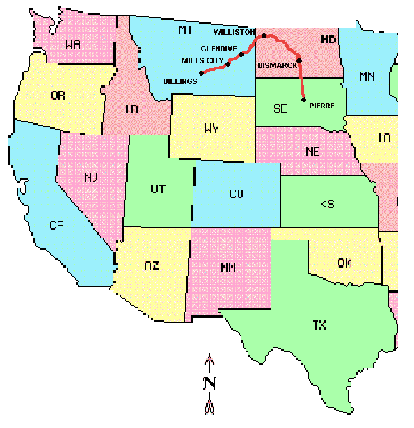
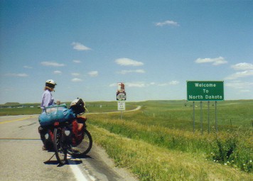
So we stood at an intersection out in the middle of North Dakota. Our route headed north with another 22 miles needed to get to someplace to camp. A sign off to our right extolled the virtues of the little town of Onida. It had a motel, grocery store, 3 gas stations, 3 restaurants, and, supposedly, 2 campsites. For a town of not much more than a couple hundred this seemed quite a lot. Yet it is the county seat, in a county having only one other town of less than 100 inhabitants. So it seemed not too unreasonable that it could possibly have all these amenities. Our choices seemed to be: We headed east. After 12 miles of nearly effortless riding we approached the grand looking Onida County Courthouse. It's one of those big, stone, box shaped buildings with Greek revival decorative features and a small dome, clock tower on top. As usual it sits right in the middle of the town square across from one of the little city parks in which we were told camping was permitted. However, upon further inquires at the city offices, down the very, very short main street, we learned that there was a second park, off the main streets several blocks, where there was both a pool and free camping as well. Now this sounded far more promising. With a few more turns of the pedals we found ourselves at a nice, neatly mowed, city park with football, soccer, and baseball fields as well as a well kept, clean, yet quite small city pool. Showers were the top item on my mind. Despite being in the "big" city of Pierre for 4 days, we hadn't had a shower in over 6. Griffin Park didn't have showers and the city pool wasn't open during the bad weather days. I wandered over to the pool to see what kind of shower arrangements could be had. "Sure," the attendant said, "we've got showers. I won't even charge you." "Great!", I thought, "free camping with free showers, what more could we want." "If you want hot water, though, you just need to flush the toilet." she then added. "What?", I said. The other girl seated behind the counter chimed in, "That's right. You flush the toilet." Not entirely convinced, I fetched soap, shampoo, and towel and headed for the "girls" shower room. I turned on the shower and sure enough out came cold water. So then I flushed the toilet. Just as promised the water turned hot, but only for as long as the toilet tank was filling. As soon as the tank was full, the shower water once again turned cold. So I spent the entire time rubbing soap on, running over to the toilet to give it a flush, hurrying back to rinse, and going back and forth for as long as it took. That was the strangest plumbing job we've ever seen. Getting to the town of Mobridge, SD was a struggle against headwinds the entire way. It's a small, railroad town of a few thousand and would be our last supply stop until reaching the North Dakota capital of Bismarck. Mobridge got it's name back when the railroad was under construction and the telegraph operators used the abbreviation Mo. Bridge to indicate the town on the east side of the bridge across the Missouri. It has everything a bike tourist could possibly want, several campgrounds nearby, two large grocery stores, lots of restaurants, and laundry facilities. I'd bet scrounging at the hardware store could even produce a few emergency bike parts if absolutely necessary. From here it would be 125 miles of virtually no services to reach Bismarck "I saw an old remains of a village on the Side of a hill which the Chief with Too ne tels me that nation lived in 2 villages 1 on each Side of the river and the Troublesom Seaux caused them to move about 40 miles higher up where they remained a fiew years & moved to the place they now live." Wm. Clark, October 19th, Friday, 1804 We managed to push through that 125 mile to Bismarck in a surprising 2 days. The first day leaving Mobridge we actually experienced light to almost zero velocity winds for the first time in days. We pushed through a full 75 miles that day arriving at the Beaver Bay COE campground out of water, out of energy, and nearly out of daylight. The second day we were finally rewarded with howling tailwinds. We sailed. We pulled into the pleasant General Silby city park, about 4 miles south of town, relieved to know that we'd managed to get through that 125 miles of no services and minimal water without headwinds for a change. After 5 days tough riding, we were good and ready for a rest. Bismarck, capital of North Dakota, is substantially larger than Pierre. It's a major prairie city of over 90,000 persons spread over the full width of the river valley. Mandan, on the west side of the river, adds several more thousand to the area's population. The river bottom surrounding the city has, over the decades, filled in with incredibly lush stands of cottonwood. Trees are so plentiful it almost seems as though you've been transported back to the eastern woodlands. Of course, climb up on the bluffs and you're back to prairie grasslands. It has become an extremely bike friendly town. In fact, North Dakota tourist guides proclaim that biking is the number one participatory sport of the state. Consequently there are bike paths to get you around town, through town, across the river, and even down to the Fort Abraham Lincoln State Historic Site. Driver's are reasonably bike aware so even riding on city streets isn't all that difficult. With interesting things to see and good bike routes to follow, we just had to stop to visit for a couple of days. Bismarck became the territory capital around 1889, just before statehood, following some rather unscrupulous politics. What else is new. Until this point the Dakota capital had stood in Yankton, further south. Dakota was still just a territory and laws and rights in territories were far less rigid than those of states. This allowed the big railroad companies to essentially run roughshod over the rest of the territory inhabitants, especially the farmers. They had encouraged farmers to come to the area giving them free, or very nearly free, passage and cheap lands. Then they turned the screws, far overcharging them for return freight of their produce. Most of the of the railroads ran east to west in the northern part of the territory. The railroads wanted to move the territory capital to Bismarck where they could continue to keep control. Southerners wanted to keep the capital in Yankton. A bill was passed saying that a committee was to be formed to select the new location for the capital. However, that committee had to have its first meeting in Yankton. So all these railroad barons got on a train and had it roll through Yankton at a slow speed so that they could quickly call the meeting to order, vote on their next meeting place, close the meeting, and roll on. Needless to say the southerners, in particular those in Yankton, felt slighted and very soon separate statehood propositions were being prepared. Bismarck's state capital building is very unusual for such a structure. It doesn't have its big, old grandiose Greek revival style building anymore. That burned down in 1931. This was a time when, rather than rebuild it exactly as it was, they would rather tear it all down and start anew. Today I'd bet they'd rebuild as it was. This was also a time when Art Deco was the newest fad. I must admit, I am not a big fan of Art Deco. Consequently the North Dakota capital building looks more like a tall, blank walled skyscraper, much like a skyscraper you'd find in any big city. High on this hill overlooking the city, standing some 18 stories high, is this big, modern office building. Only the fact that it stands all alone makes it stand out so. It was built for $2 million and is believed to provide the most usable space for the money of any of the more modern state capitals, a fact they seem quite proud of. We noticed in reading the brochure describing the materials used to build it, that nearly everything, from stone to lamp fixtures, came from some other state. That and refusing to yield to striking worker's demands is probably what made it so cheap. Anyway, we still think it's not a particularly pretty building. Functional, yes. Awe inspiring, nah. What we really enjoyed was the Fort Abraham Lincoln State Historic Site across the river. This is the location of that abandoned Mandan village Lewis and Clark noted in their journal that day 200 years ago. It's located on a flat topped slightly inclined bluff overlooking the river and is now called On-a-slant village. Having been abandoned only about 25 years, the Corps would probably have found ruined structures that gave a clear idea of the extant of the village.
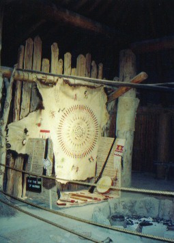
In the 1930s the CCC rebuilt several of the old earth lodges under the instruction of a very elderly Mandan woman named Scattered Corn. Typically the Mandan women would build their own earth lodges, a structure some 20 to 30 ft in diameter. They were also the lodge owners. Men would build the council lodge mainly because it was much bigger, 60 ft in diameter or so, and required much larger wood. Each earth lodge had four vertical cotton wood posts in the center capped with four more horizontal posts. In a circle around the lodge are many shorter vertical posts again capped with horizontal posts. Long diagonal posts reach from the top of the center caps down to the lower caps on the outside circle. All of this, except for the center smoke hole, was covered with a woven willow mat and then dirt. Inside, once the floor had been packed down, there were raised wooden platforms for beds, bison hides on the floors for rugs, woven chair backs for leaning, and basically all the accoutrements for daily living. These lodges stayed cool in summer and hot in winter. They were actually rather cozy. Although just imagine spending an entire winter cooped up in one of these lodges with 14 other people, a bunch of dogs, and then horses in the later years. The odors must have been unbelievable by modern standards. One of the rebuilt lodges has been set up to look just like a very clean and pristine example of the old lodges. Also located in the park is the remnants of the two forts comprising Fort Abraham Lincoln. In 1871 two infantry divisions were sent out to protect the construction of the Northern Pacific Railway. They built their post high on the bluff just overlooking the site of the Mandan village. They built large blockhouses connected together with a wood palisade in a chevron pattern facing the prairies. The river and walls of the bluff were at their back. They had the usual bunkhouses, hospital, officer's houses, powder house, stores, etc. All were build of green wood covered with paper so that when the wood dried and warped, huge gaps in the walls made for one drafty, cold place. Today only the three blockhouses have been rebuilt. It wasn't long after they arrived that they discovered that men on foot were no match for the skilled, native horsemen. A Calvary unit was sent in 1872. This was the famed 7th Calvary unit under the command of Lt. Col. (formerly General during the Civil War) George Custer. His unit built a large complex down off the bluff. The fort was set out in the usual rectangular pattern with officer's quarters on one side, barracks on the opposite, granary, commissary, hospital and guardhouse on the others. The stables were closer to the river. It was in 1874 that Custer took his 1200 man troop out to the Black Hills to look around. It was clear from the start that they were specifically looking for gold. They took several miners with them. This was a clear violation of the treaty with the Sioux which stated that no white man shall set foot in the Black Hills, land considered sacred. Personally, I doubt Custer really cared. Once word of gold got out, prospectors flocked to the hills. The government made a weak effort to keep them out while they tried to buy the land. The Sioux wouldn't sell. From then on the government just let the prospectors do what they pleased, the Sioux retaliated with raids against the settlers, and the Indian wars had begun. Fort Abraham Lincoln was abandoned in 1891 after Custer's huge bumble at the Little Big Horn, after Crazy Horse and Sitting Bull had been chased and beaten into submission, after it's role in subduing the natives became obsolete. The 7th Calvary was moved to Ft. Meade in Wyoming and the buildings left to the scavenging of the new settlers moving into the area. Within 4 years little remained. Today the commissary, barracks, granary, and Custer's house have been rebuilt. New stables are under construction. It's not too often we meet bike tourists who've "been around the block" as often as we have. But, Phil and Jill come very close. We ran across these bikers at the General Silby park near Bismarck. We could tell they were fairly experienced bike tourists almost without even going over to chat. They had their bikes covered with a tarp, a trick many a tourist learns only after the first 2 or 3 tours. Phil and Jill turned out to be a couple of gray haired, retirees riding a couple of extremely well worn touring bikes. In fact, Jill was beginning to experience major equipment failures, a broken rear wheel rim after 20K plus miles and clipless pedal shoes that literally ripped apart. They seemed to be riding from bike shop to bike shop on this particular tour. When Phil retired he had set his sights on hiking the Appalachian trail. For years he'd collected books, read articles, learned everything he could about long distance hiking, and even hiked several small sections. However, when retirement time came and he was all set to go Jill piped up, "What about me?" So ended that dream. They agreed on doing a coast-to-coast bike tour instead which was just the start of their touring days. Since then they have ridden Australia, New Zealand, across the U.S. twice, from Alaska south to Colorado, England, and the Netherlands. These were definitely our kind of bikers. We could talk for hours and hours trading good old bike tourist stories., but alas the weather was clearing and we really wanted to head on. Unfortunately, between the predominant headwinds we were getting this year, the failing equipment, and just a general stubbornness not to admit that doing less than 50 miles a day is perfectly fine, they have decided to call it quits at Bismarck. Phil grumbled that this would probably be their last self-contained tour. From now on it'd be sagged tours only. They feel they just don't have the stamina anymore. I wonder if after a while they'll change their mind and decide to do loaded tours with shorter daily distances. Fourth of July was finally upon us. We fully expected the character of the campgrounds to drastically change from quiet and nearly empty to a cacophony of noise and activity. RVs by the thousands would soon hit the roads trailing fishing boats behind. Campgrounds would be completely full. So we made a strategic decision to slow down a bit, visit several museums, and aim toward staying in the local city parks. That way we'd get to Lake Sakakawea just at the end of the weekend, perfect timing. Although, even though these places are called "campgrounds" it seems to us that very few people camp anymore. Let's face it. Pulling into a site with one of those "big rigs" that come complete with stove and oven, air conditioner, 30 inch TV with satellite reception, master bedroom suite, and basically all the things one has in a house and then calling it "camping" is rather far fetched. It's more like taking a second home out for the weekend. Campgrounds are responding to or even encouraging this trend. We've noticed that all of the more developed campgrounds have anywhere from 75% to 100% electric sites. These are called "modern" sites. The ones we would consider real campsites are now called "primitive". We tenters are rapidly becoming an endangered species soon to appear on the Federal Endangered Species list. "Set out early a cloudy day Some little Snow in the morning I am Something better of the Rhumitism in my neck. a butiful Countrey on both Sides of the river. the bottoms covd. with wood, we have Seen no game on the river to day", Wm. Clark, Oct. 24, 1804 The route out of Bismarck is quite pleasant. A bike trail took us through dense cottonwood forests around the west side of the city. The lush surroundings took us by complete surprise. It's not exactly what one expects out on the prairies. All too soon we were once again out on the main roads yet still staying in the lush river bottom as we headed north. We passed by the Double Ditch Indian village site very early. This is another one of the sites used by the Mandan back in the 1500s to 1700s. All that remains today are those circular depressions where the 50 some odd earth lodges stood and two long, curving ditches where the palisades and defensive ditches were located. The first and only archeological dig performed at this site was done in 1905 and was very, very limited. This day we were fortunate enough to see the start of a brand new and very extensive dig. Piles of dirt, wheel barrows, and squatting figures crowned several of the big midden mounds. Closer to the river was a washing stand and many sorting tables. They seemed full of discovered artifacts already. Even as we prepared to leave another truck loaded with still more wheel barrows pulled up. It appears that this summer they will complete one very, very extensive survey. I was thinking, as we rode away, that to be an archeologist you've to, first, really love dirt and, second, love spending hours on end in the hot sun squatting over that dirt you love so well. Yet, I'll bet the excitement of finding something really special more than outweighs all the negatives. With the Missouri river on our left shoulder yielding nice views all the way, we worked our way north. The bottoms remained full of cottonwoods while the bluffs stood out as open grasslands. We counted ourselves lucky this year. It'd been a rainy spring/early summer and, as a result, the hills all remained green. Both previous times we'd made a trek across the prairies had been in August during drought years. All was brown, including the farm fields. We had not been looking forward to the brown this year. Needless to say we were absolutely delighted to see the brilliant greens of an unusually wet year. That's not to say the rain isn't annoying for biking. But the scenery is far better this way. Just south of Washburn we pulled off at a small boat ramp/campsite. It overlooked the river, had huge cottonwood trees giving great shade, and even had 2 covered picnic tables. We noticed a couple of women soaking up the sun by one of the tables. We took the other. The question was, do we stop here for the night or go on to Washburn as originally planned. The site was just too good to pass up especially at the price, free. Now how could we resist this temptation. We stayed. I soon had made my way over to chat with the two sunbathers. These were a couple of the nicest women. Christine, a very light skinned woman with short dark brown hair and Kim, a tall, slender woman of half Indian blood. While I sat, enjoying the cold beer they offered and described some of our journey, Kim suddenly announced that she wanted to show us true North Dakotan hospitality. They promptly hopped into the car for a quick trip to the Washburn grocery store to buy us dinner. I was left looking after the three little dogs. Wow! How nice. It'd be great to have something for dinner other than canned meat and noodles. They weren't gone more than 10 minutes when I looked up to see black clouds to the west. "Where in the world did those come from." I thought. Brian and I were soon running around gathering up our belongings plus Kim and Christine's as well as trying to convince the three dogs to stay in one place. Before long the skies broke loose and once again we were in the midst of one of those violent downpours. Kim and Christine showed up in the middle of all this rain and, much to my and the dogs' relief, took them under their wings. And we all waited, crowded under those much appreciated table covers, for nearly an hour. It was amazing just how quickly we could go from a hot, sunny afternoon to a major maelstrom, and afterwards back to calm and clear. This western weather sure is fickle. Anyway, Kim and Christine had come back with a veritable feast of sandwiches, cherries, cold chicken, chips, beer, and water. What a treat. yet even after they had gone home and we got our tent set up, one of the fishermen who'd just pulled in his boat also asked if we needed anything, including dinner. We definitely are impressed with North Dakotan hospitality after all.
"a fine morning we continued to cut Down trees and raise our houses, a Mr. chubonie, interpeter for the Gross Ventre nation Came to See us" Wm. Clark, Nov. 4, 1804
Between October 27, 1804 and March 21, 1805 the Corps of Discovery spent the winter within a short distance of several of the Mandan villages. They raised a small fort constructed in a wedge shape of local cottonwood for the walls and gates and stone and clay for the fireplaces. It had 4 rooms for the soldiers on one side, a room for the captains, interpreters, blacksmith shop, and on-duty guards on the other. A storage facility was located at the peak of the wedge and the wide end was basically a wall and gate. In reading the journals, it seems they spent the majority of their days entertaining visitors. It was while at the fort that Touissant Charboneau came to call with the idea of being hired as an interpreter. He brought his two wives, Otter Woman and Sakakawea. Sakakawea was pregnant and gave birth at the fort on Feb. 11 after a long and difficult labor. Another interpreter, Mr. Jessome, suggested grinding up the tail of a rattle snake, mixing it with water, and giving it to her to drink, "which he assured me had never failed to produce the desired effect, that of hastening the birth of the child;" Even Clark was skeptical of its efficacy, but no more than 10 minutes later she "brought forth." Maybe this old folk remedy deserves further study. Little Jean Baptist, or Pomp as Clark would call him, immediately became the youngest member of the expedition. Interestingly, Charboneau was very nearly kicked out of the group and out of history right at the outset. He must have placed far too high a value on his services as he insisted he would not stand guard, would quit the group if he became miffed with any man, would have use of any provisions he chooses, and would not do any of the work. He was fired on March 12 with Clark noting that their agreement was only "virbal" anyway. On March 17th Charboneau changed his mind and agreed to all terms set out by the captains thus saving for himself, Sakakawea, and little Pomp their place in history. Sakakawea, while important to the overall success of the mission, was really not as much a one-woman-show as later history books would make her out to be. She did provide some guidance and pointed out some major landscapes when they were near her home grounds. She did point out edible and medicinal plants along the way. She did save many of the most important scientific instruments by grabbing them from the water after they'd fallen overboard. She did help them procure horses from her brother Camayahuait, chief of the Shoshoni. Perhaps her most important contribution to the mission was just being there. A woman and baby among a group of very heavily armed men was a clear signal that these were not men on a hostile mission. She was not the girl guide who lead them to the Pacific and back. This manifestation of her came into being during the heyday of the women's suffrage movement when some sort of leading role model was sought. They made up an entire persona that simply did not exist. Not much is known about her. She was captured at about the age of 9 by the Hidatsa, sold to the Mandan, and taken to their village as a slave. Charboneau either bought her or won her in some sort of gambling competition. She gave birth to Jean-Baptist who accompanied them on the trek and a second girl after their return. Some evidence indicates she died while at Ft. Manuel in North Dakota I believe around 1812. Records at the trading post make reference to the wife of Charboneau dying which could also have been Otter Woman. Other people believe she changed her name, moved to Wyoming, and lived to be a very, very old lady. It is unlikely we will every know. Time at Ft. Mandan, as the Corps named their little house, was rather interesting indeed. They had to suffer through the severe northern winter where temperatures regularly reached 10, 20, and even 40 below zero. Frost bite was common even among the Mandan. Clark had the unpleasant task of having to amputate the toes of a young Mandan boy who'd been out on a hunt overnight in simple light clothes. At another time the boats were in such danger of being crushed by the river ice they decided to move them ashore. But, getting them out of the ice to make that move proved to be far more difficult than they'd thought. They tried heating the ice, but it refroze as fast as they got it melted. Finally it took brute force, chopping and hacking, to break them free enough to move. The natives, needless to say, were all excited to see these big boats up on dry land. Because they were a sedentary folk living primarily on agriculture, the Mandan villages had become a major trading center for the nomadic tribes. The nomadic tribes seemed to either trade or raid as the mood suited them. They viewed the Lewis and Clark group as simply another set of customers. For the corps, having this group of natives close by with their large supply of stored grain proved to be quite fortunate. The men hunted for meat. They traded for corn. They gave medical assistance for bushels of corn. They repaired metal tools and axes for corn. They made new battle axes for corn. You might say they became arms dealers of the west. This created a rather odd ethical dilemma for them. On the one hand they had little else to trade to get the grain they needed once all the other tools and implements brought to them were repaired. On the other hand, the axes they were making were being used to wage war on other tribes. And here they were trying to create peace between all these different groups. It almost seems as though their actions weren't quite in sync with their words. Of course the men had plenty of entertainment, especially with the women. Lewis often noted that the men contracted venereal disease from the Indian women. Or they noted that women were "given" to the men to sleep with, either as part of some sort of ceremony or for the man giving the woman to gain honor. In one instance a young man became insanely jealous because he thought his woman was cavorting with the white men without his permission. He beat and stabbed his wife and even threatened to kill her, either that or give her to the corps to keep. Another man wanted to give a woman to the corps for them to take along. She had become besotted with one of the men. The captains refused. One of the corps members was court marshaled and punished for climbing over the fence after hours, he'd been out with a woman too late. His punishment was given because he showed the Mandans how easy it was to scale the wall, not because he was sleeping with the natives. Needless to say those boys did not exactly pine away all lonely through that particular long winter. One has to wonder if scattered among the Mandan, Hidatsa, and Arikara there aren't a few descendents of those energetic corps members wandering around today. And so when spring came and the ice broke free on the river,the captains ordered the boats loaded and everything made ready for departure. The keelboat was sent back down river with boxes containing various specimens and documents gathered to this point. Included in this shipment to the president were 4 live magpies, 1 live grouse, and a live prairie dog. Only 1 magpie and the prairie dog made it all the way. Once it's mission was complete, the keel boat disappeared from the pages of history for good. The two perogues and several canoes continued upriver. The little Fort Mandan was burned between the time the corps left in March, 1804 and when they returned in 1806. Today, the exact location of the fort is unknown. It is believed to be under the river somewhere about 12 miles north of the town of Washburn. But, there is a Fort Mandan you can visit.
Just to the northwest of Washburn is the Knife River Indian National Monument. This is another of the Mandan/Hidatsa earthlodge villages. This was the one that was inhabited when Lewis and Clark passed through. Now all that remains are those familiar sunken circles. Most interesting is the rebuilt earthlodge. It's filled with all sorts of recreated artifacts giving it an almost lived in, albeit super clean lived in, appearance. Seeing as it takes an extra 30 miles to visit this site, I'd be willing to bet most folks skip it. We think they're missing something special. Stretching for nearly 200 miles across the northern section of North Dakota is the enormous Lake Sakakawea. Of course, it's a man made lake being the result of the Garrison Dam. It is huge. Unfortunately drought has plagued the mountains for many years. As a result the entire string of lakes along the Missouri are significantly low. Lake Oahe is over 38 feet down. Lake Sakakawea is 27 feet low. Boat ramps are closed. Docks have been pulled up, high and dry. Fishermen have to go to a great effort just to find a spot to put in their boat. We followed along the northern shore of the lake, a good distance from it, headed east to west. For once, the first time this tour, we finally had a howling tailwind. Just imagine how much fun it is to race along at an amazing speed. We rolled up and down these 250 ft rolling hills feeling as though we were just barely working up a sweat. Prairies stretched off forever. We could see at least 10 miles off. This was the kind of day bike tourists live for. We hauled off a full 83 miles and felt we could have gone further. Williston, ND has become a crossroads of cross America bike tourists, a fact that both surprised and delighted us. In 1988 when we road the northern route for the first time we saw absolutely no other bike tourists while out on the prairies. Granted the Northern Tier was brand new, having been mapped only a year or so earlier, which would explain the lack of other tourists. But, what a change now. We spotted a lone rider as we headed into Williston. He was huffing and puffing up a hill and looked in no mood to chat. At the RV park we met 3 women who were sort of riding the northern route, sort of doing their own thing. We met a bike shop owner who told us about a group of 3 who'd spent the previous night in the city park and another group who'd passed by a day or so earlier. There was even a sagged group visiting the day we'd arrived. Although sagged tourists really are a different breed than those of us who are on our own. Williston hasn't much to offer other than a very good supply stop. Yet it's so cool to see it becoming such a biker's meeting point. Bike tourists reign. "when we had proceeded about four miles, I ascended the hills from whence I had a most pleasing view of the country, particularly of the wide and fertile vallies formed by the missouri and the yellowstone rivers, which occasionally unmasked by the wood on their borders disclose their meanderings for many miles in their passage through these delightfull tracts of country" M. Lewis, April 25, 1805 As Lewis and Clark proceeded up the Missouri they made various notes as to the terrain they were passing. Among these notes were comments regarding potential locations for military forts and trading posts. One such location was at the confluence of the Missouri and Yellowstone Rivers. It had great potential as a trading center for the Assiniboines living up the Missouri and on into Canada, the Cree up the Yellowstone and the Blackfeet even further up the Missouri. In addition, the Mandan, Hidatsa, Arikara, Crow and Sioux weren't all that far away either. Twenty-five years later that prophecy was fulfilled with the building of the Fort Union Trading Post. Fort Union was one of the wilderness fur trading centers funded and operated by the American Fur Company, a John Jacob Astor holding. Astor made his money through a triad of businesses; real estate in New York, shipping to the Orient, and the fur trade. His trading posts extended way to the west up the Missouri River. It even included some posts on the Great Lakes, Mackinaw Island for example. Fort Union, being a major trade center, was built in a luxury and style that one would be more likely to find in populated areas such as St. Louis. The centerpiece of the fort was the large Bourgeois House surrounded by a 20 ft tall palisade. The Bourgeois was essentially the post manager and head trader. It was a big, 2 story, white house with a brilliant red roof complete with fancy wind vane on top. Centered on the front of the house was a large 2 story portico which added to the impressive front. On each side of the house were two long buildings, one used for housing the 100 odd employees and the other was the store house for goods coming and going. All along the palisades were dozens of small sheds whose purpose varied as necessity demanded. At the front of the palisade were two gates in-between which was a door that led to the trade room and store. The outer gate could be opened to allow potential customers into the trade room whole the inner gate could be kept shut for security. On diagonal corners of the palisades were two stone guard towers, each whitewashed and having brilliant red roofs and wind vanes. The entire complex was meant to be a show piece as well as to really stand out on the prairies. Trading was a very formal affair. Usually the steamboats would arrive sometime in June or July depending on the height of the river water. Many of the native tribes would specifically time their arrival to match that of the boats. Consequently there could be thousands of tipis irregularly scattered around the fort. Trading began with the tribal leaders coming to the fort to meet the head trader for a negotiating session. They started with the Bourgeois wining and dining the leaders. They never got to the business end of the deal until this crucial entertainment step was complete. However, once this was over, they both got straight to trade talk. Tribal leaders would show example furs they had and they would bargain for a price, price being trade items such as blankets, beads, axes, etc. When they were done they'd have established that X number of hides was roughly equivalent to Y trade goods. The leader would then return to his tribe and tell them the equivalent trade value. From that point tribal members, men, women and children, would appear at the small trade windows of the store to trade whatever furs they had for what was on the shelves. They'd never trade all they had at once. They'd pick and choose a few items, go back to think about what else they needed, and then return for more later. Trading with an individual tribe could take a good month. It must have been quite a social time around the fort during that time. Of course there could be problems. Many tribes would be camped near the fort at the same time and many of them were not exactly on friendly relations with the others. The Assinniboine, who considered this site to be within their territory, tended to keep the peace and act as a police force, but even they could get into trouble especially if alcohol were involved. Now importing alcohol for other than medicinal use was supposed to be strictly illegal. But, the Assinniboine made it quite clear from the start, no booze, no trade. So the first Bourgeois, McKenzie who was a shrewd Scotsman with many years trading experience, carefully read the law on alcohol. It said you couldn't import alcohol. It did not say you couldn't make it. So he set up a still, bought corn from the natives, and set about making good old moonshine. The company did get caught, eventually, and had to pay out a fine of $15K which, for 1800s time, was a formidable sum. Just the fact that the American Fur Company could afford this fine and still continue operations attests to the magnitude of its wealth. Eventually the fur trade wound down. Silk hats replaced beaver. Also, the number of natives in the area dwindled substantially as a result of two small pox epidemics. The more aggressive Sioux moved into the area to take up the vacuum and relations just became too hostile. In 1866 the fort was sold to a competing company and again in 1867 it was sold to the military. The military dismantled most of the buildings and used the materials for building Ft. Buford nearby. Various scavengers, including the steamboats, took the rest. Before reconstruction took place about the only remains to be found were the stone foundations and a fireplace hearth. Today, the walls, guard towers, trade room, and mansion have been rebuilt to its 1851 splendor. By 1866 settlers had begun to move onto the prairies forcing the natives onto smaller and smaller parcels of land. Many of the nomadic tribes resented this usurpation of their hunting regions and rebelled violently. The Sioux were particularly fierce. Just as the fur trade business was winding down, military action was gearing up. Ft. Buford was established about 2 miles east of Ft. Union in 1866. It eventually grew to house 6 companies of cavalry and infantry. It was a major frontier fort and was the scene of some of the more dramatic episodes of the Indian wars. Nez Perce Chief Joseph, Gall, and Crow King were all at one time prisoners of war at the fort. But, it's most famous prisoner was probably Sitting Bull. After returning from exile in Canada in 1881, Sitting Bull turned himself in at Ft. Buford. He was later transferred to Ft. Randall where he was shot under dubious circumstances. With the surrender of Sitting Bull the Indian wars essentially came to a close and the role for the military on the frontier began to diminish. Ft. Buford was closed and, as was the custom of the day, the buildings scavenged by the newly arrived settlers. Even the entire hospital building was moved lock stock and barrel into the town of Buford to become the St. Elmo hotel. All that remained were the powder magazine and one of the officer's houses. When we visited, a replica barracks building was under construction and that officer's house under renovation. Otherwise there were just a few signs and holes in the ground to look at, not much else. As Lewis and Clark headed west in 1805 they chose to continue on the Missouri River right up to its source. On the return in 1806 they split. Capt. Lewis went on to explore the Marias River further north while Capt. Clark took the more southern Yellowstone River. They had agreed to meet up once again at the confluence of the two rivers and they actually did both arrive at a spot just a little further east within nine days of each other. Thus the route we have has an option, continue on the Missouri or head on up the Yellowstone. Having ridden the across Northern Montana on Rt. 2 years ago, we chose to try the Yellowstone this time. So at the confluence we crossed over the Missouri river and bade it farewell for now. We'd not be seeing it again until we arrived at Three Forks where it's be a whole lot smaller than it was here. Temperatures were beginning to soar. While we'd been fortunate to have a relatively cool spring and early summer, July would see rocketing heat. This would be a time when riding in early morning or late evening would be a must. Each morning we arose at the crack of dawn, hauled off some 30 to 40 miles before a break, and then decided whether or not to continue. Unfortunately, it also seemed we started doing higher and higher mileage each day; 77 miles into Glendive, 83 miles to Forsyth, 73 miles to Laurel. But we were anxious to get to the mountains where both temperatures and bugs would be far more tolerable. "passed the entrance of a large Creek, affording but little water; this stream we named Blowing Fly creek, from the immence quantitites of those insects found in thei neighbourhood, they infest our meat while roasting or boiling, and we are obliged to brush them off our provision as we eat." M. Lewis, May 20, 1805 Ah yes, we know how they felt. Those sultry temperatures brought upon us in early July were accompanied by swarms of flying insects. We'd been fortunate thus far as not even mosquitoes had been too obnoxious, that is until we hit Montana. Then we found mosquitoes, flies, and gnats in quantities more than sufficient to make up for their previous absence. I suppose one can only grin and bear it with as much fortitude as possible as Clark did as his comment "Mosquiters verry troublesome." became oh so familiar. Actually, the mention of mosquitoes in the journals brings to mind Clark's more "humorous" side. Unbelievable as it may sound, I've not been making gross spelling errors in my various quotes. Back in the early 1800s spelling was more of an art than a science. Children were taught some of the basic spelling rules phonetically, you might say they had a beginning "Hooked on Phonics" course. From then on they just spelled words as they sounded. National spelling bees were not an obsession. Some words are easy to figure out such as verry, retragrade, merchandize, and swivell. Some words require knowledge of text; could (cold), atmispier (atmosphere), despurcing (dispursing). Even more surprising is the variety of spelling used. He didn't just simple choose one form of spelling and stick with it. He often varied spelling the same word each time it was written. The word mosquito was probably the most variable of his spellings as I understand he used over 40 different versions; musquiters, mosquiters, musquitors. Needless to say all this different spelling can make reading the journals a bit of a challenge. "The natives have ingraved on the face of this rock the figures of animal &c. near which I marked my name", Wm. Clark, July 25, 1806 Much to our amazement and delight we actually experienced 3 days of tailwinds as we pursued our way across eastern Montana. This was a definite bonus as struggling west across this most prairie like section of the trail against fierce headwinds would not have been fun. We started seeing pine trees on the hills near Forsyth, a sure sign that the mountains weren't far off. We made a brief stop at Pompey's Pillar National Monument, the site where Wm. Clark inscribed his name which is the sole remaining physical evidence of their passing. We pushed on past Billings in a 73 mile day, stopping only to choke at the ridiculous $28 camping fee at the Billings KOA. Then just before Laurel, after so long a time, we spotted our first snow covered peaks, the Beartooth Range off to the southwest. These peaks we have been so anxious to see. From now until Astoria we'd be doing a lot of mountain riding, our most favorite touring of all. "while I viewed these mountains I felt a secret pleasure in finding myself so near the head of the heretofore conceived boundless Missouri", M. Lewis, May 26, 1805 References1. The Journals of Lewis and Clark, Edited by Frank Bergon, 1989, Penguin Books USA, Inc., New York, NY. 2. Fort union Trading Post, Brochure printed by Friends of Fort Union Trading Post, 1999 3. Fort Buford State historic Site, brochure printed by State Historic Society of North Dakota Appendix A - RouteSouth DakotaJune 26 - 51.25 miles ACA route, side route to Onida MontanaJuly 12 - 76.66 miles ACA route to Glendive
Appendix B - Campsites or hotelsSouth DakotaJune 26 - Onida city park North DakotaJune 29 - Beaver Bay Rec. Area ($8) MontanaJuly 12 - El Centro Motel, Glendive($31) |
|
Copyright © 1995-2011 by Caryl L. Bergeron - Distribution for personal use permitted. Distribution for other uses with written permission.
Acknowledgements
|
 Of course no trees means more winds. Across the prairies there is nothing to stop or slow the progress of those blasted winds. As our luck would have it, the winds seemed determined to obey Caryl & Brian's
Bike Tourists' Rule No. 1:
Of course no trees means more winds. Across the prairies there is nothing to stop or slow the progress of those blasted winds. As our luck would have it, the winds seemed determined to obey Caryl & Brian's
Bike Tourists' Rule No. 1: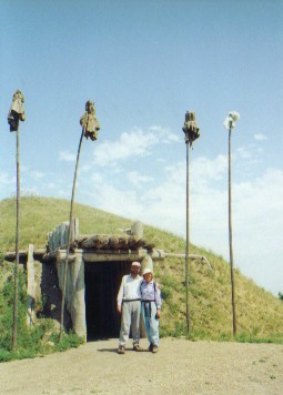 Today, there are merely round depressions indicating locations of the round earth lodges, indications where the wood palisade stood, and refuse piles. The village had been inhabited from about the 1500s until 1781 when they moved further upriver.
 Washburn volunteers built a modern replica in the 1970s just a couple miles north of town, a definite must stop for anyone following their trail.
 Only the black clouds and lightning striking the hill tops forced us to stop early. Whether or not we'll see another such day remains to be seen. At least we did have one.