| Caryl and Brian's World Bike Tour |
|
Northwest Tour 2011 VII - Canada Great Parks North |
![]()
![]()
![]()
![]()
|
|
Northwest Tour 2011 VII - Canada Great Parks North
NORTHWEST TOUR 2011 PART VII - Canada Great Parks North
Baynes Lake, BC to Lake Louise, AB June 7 to June 14, 2011 Start 64,237 miles (102,779 km) cumulative: End 64,462 miles (103,139 km) cumulative
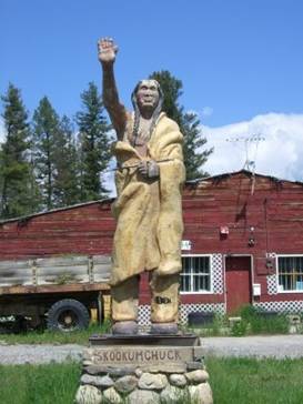
Statue at Skookumchuck
TEASERS
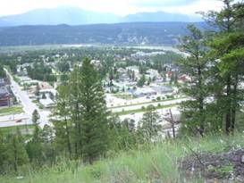
Flooding and more rain at Cranbrook Great place names in the northwest How did Johnson Lake get formed Hot springs with a radiated kick People act crazy around bears Visit paint pots and Marble Canyon Play with road building equipment Humans in the cage, bears outside at Lake Louise June 7 - Easy riding Another day of rainless riding with partly cloudy skies! Well, almost. But we did get at least a half day making it 3 1/2 good riding days. That’s a record so far this summer. We had a choice. Stay on the ACA Great Parks North route to Fort Steele or break off toward Cranbrook. Since we were expecting another day of heavy rain we decided to head into Cranbrook where there are plenty places to stay out of the weather. Although this did mean riding along the busy Canada route 3. While in the US the major transcontinental highways are 4 lane, divided, limited access roads, Canada’s are not. They look more like normal 4 and even 2 lane roads. With a population about 1/10th of the US you can see why. But for the first time visitor this may seem a bit odd. We’d forgotten how little there is to be found along these roads in BC. It seems you spend hours and hours cruising along the tree lined road seeing nothing but trees and an occasional house. The further north you get the fewer and fewer houses you see. Fortunately there’s usually some breathtaking natural scenery to look at. Otherwise it really could be a rather boring ride. As we approached the intersection that would take us to either Fort Steele or Cranbrook the skies to the north were becoming crowded with black looking clouds. Our weather reprieve was coming to an end. We hustled on into Cranbrook, down a long hill, arriving just in time for the first raindrops. It started raining and did not stop all night long. June 8 - A day to relax Cranbrook has become a major service town for people traveling route 3 and tourists visiting the parks. It’s really almost 2 towns. The main highway traverses in a northeast to southwest direction. It is absolutely lined with hotels, restaurants, and all the major stores for at least 2 miles. Angled away from the highway to the east is the original part of town. Here you find the things that really make up a town, a rectangular street grid, city offices, library, schools, hospital, parks, etc. Most travelers never get into town proper which is a shame. There really is more to Cranbrook than the highway.
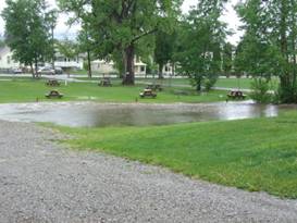
Flooding at Cranbrooks campground We had camped in the nice town park, Baker Mount RV park. Through the center of this park runs a small creek. Although on this day it wasn’t all that small. With all the rain there’s been it was overflowing its banks and turning much of the tenting area into a pond. Fortunately there was only one other tenter and they had a few high tent sites. Flooding of the creek in Cranbrook’s RV park Everyone is beginning to wonder when will it stop raining. We spent another day, hanging around, waiting out another day long storm. It almost seems that this year your choice is broiling hot or chilly and wet. Nothing in between. It’s an odd year that’s for sure. A look around Mount Baker campground The attendant at Kikomon Provincial park told us they’re expecting 4 to 6 weeks of very hot weather this coming summer. So maybe then we’ll be glad we chose the northwest for riding. We’re certainly glad we’re not trying to do a thru hike this year. June 9 - Skookumchuck
Ah these northwestern names, you gotta love em. There’s Skagit and Skeena, Koocanusa, Skookum and Skookumchuck. How about Spallumcheen, Chilliwack, Kamloops, and Lillooet. Or maybe the famous 100 Mile House and 150 Mile House. Just for fun let’s add Ta Ta Creek and Ha Ha Creek. Really there are some great names here. After a long night and day of rain the sun finally returned and we headed onward. In the morning we loaded up with groceries from the Supercenter and headed on. Funny the down hill into Cranbrook seemed a lot steeper when we came in than the subsequent return up hill. Maybe it was that day of rest. We cruised past the Fort Steele Heritage park without stopping. We’ve already seen it. They’ve collected a bunch of local historical buildings around the old Fort Steele grounds. There’s the usual school, church, blacksmith, farms, town houses, store, and of course the saloon. It’s worth a stop if you’ve never been. We were now making a nice easy run up the Kootenay river valley. The wind was at our back and the weather just about perfect. It really was a top notch day. There are only a few very small towns on the way. Wasa we didn’t stop at. Just 11 miles further we did stop at Skookumchuck, named after either a native tribe or a person we’re not sure which.
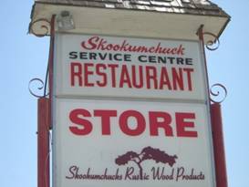
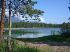
The store at Skookumchuck Here there are 2 motels/campgrounds, a small store/cafe/gas station that has a few RV sites, a burger stand, and a statue of Skookumchuck. Groceries are very limited. Here’s Skookumchuck We could have camped there but we learned that there was Johnson Lake just a few miles further where there’s free primitive camping. Free’s good. We headed there. With a short bouncing ride down a somewhat steep dirt road we came to the pretty Johnson Lake. There are 2 pit toilets and 5 tables. Surprisingly there was a trailer already in one site and a picnicker at another. We hadn’t thought it’d be even this crowded. Ah well guess we have to share.
Pretty Johnson Lake June 10 - Another tire
Johnson Lake was a nice, free spot to spend the night. But we learned that it wasn’t always a lake. A look around pretty Johnson Lake The nice lady camped in the trailer next door invited us for hot chocolate, an offer to good to refuse. As we sipped she told us a little history about Johnson Lake. Naturally it was just a bit of a swamp, not a very attractive one either. Her husband evidently worked with the crews building the new highway in the 70s. It was a long, hot summer. One day the crew decided to make a little unauthorized use of the road grading equipment. They built a road to the valley. They then took a bunch of sand and earth to dam up the creek turning the swamp into a little lake. It became a nice camp and picnic spot for the locals. At some point a few picnic tables showed up. Then a couple pit toilets were built and Johnson Lake became a pleasant free little campground. Just imagine a road crew trying to do that today? Not too much further down the highway we came to Canal Flats. The town of Canal Flats has a huge ongoing lumber industry. So while lumbering has been killed in Montana, it’s alive and well here.
Services at Canal Flats This area is so named because there once was a canal here. If you look at a map you can see that the Kootenay river dumps out of the Rocky mountains and passes within just a km or so of Columbia lake. The Columbia goes on a long journey north and south and finally connects with the Kootenay way down in Oregon, many hundreds of miles later.
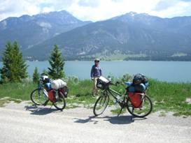
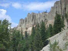
Overlooking Columbia Lake In the 1800s a fellow dug a canal connecting the lake with the river. However due to intense flooding restrictions only 2 steam ships ever passed through. The canal is almost a wetlands today. With a nice wind at our back we sailed along northward until we turned off on Westside Rd just before Fairmont Hot Springs. In this area are some unusual hoodoos. Hoodoos are spires of soft sandstone etched from a cliff by the forces of wind and rain. Although the local natives have a legend that says they are the rib bones of a giant monster that was killed by by the other animals because it was so evil. They killed it, ate the flesh and meat, and scattered the bones around.
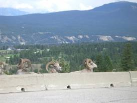
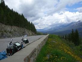
Hoodoos near Fairmont Hot Springs That Westside Road is one hilly route. It stays far to the west of Windmere Lake, up on the shoulder of the mountains. To the east are the most amazing looking mountains. They extend north to south for miles and seem to rise straight up from the valley. With the snow covered peaks they look lovely. Stunning. About halfway along this road my rear tire starts feeling soft. Another flat. As we’re changing the tire we noticed that it had been slashed very much looking like the work of vandals. My skewer was also very loose, much more than should be. So now I needed another tire. Fortunately just down the road and down the hill was the town of Invermere which happened to have a very nice bike shop. They had a good relatively reasonably priced tire. I was good to go. All the different times we’ve been in this region we’ve never stopped into Invermere. It might have something to do with that very steep hill going down to the river and back up. But Invermere really is a cute town. If you can do the climb it’s worth it. After climbing back to the highway we rode just a few more miles to Dry Gulch Provincial park. We really are astounded with the costs of the Provincial parks in Canada. For $21 we got just a table, water, pit toilet, and trash pickup. Not much different from Johnson Lake but costing a whole bunch more. And the park management had planned to increase it even more. Complaints from the locals has forced them to hold prices for one year. Next year, lookout. June 11 - Now we’re getting lazy Radium Hot Springs was just a few short miles up the road. Along the way there are a set of 3 large vehicle turnouts. You get great views of the wandering Columbia River and the mountains to the west at each stop. The Columbia is an amazing river. It starts at Columbia Lake just north of Canal Flats. It swings hundreds of miles north to Mica, then swings south again to Oregon, and then west to the Pacific. It’s a journey of thousands of miles. Overlooking the Columbia River valley At one stop we looked up and there were a bunch of bighorn ram sheep sitting there as calm as can be. Obviously they’re very used to us gawkers. They had those large curving horns that makes their species so distinctive.
Bighorn sheep near Radium Hot Springs Bighorn sheep sitting be the pullout Just a short hop and we arrived at Radium Hot Springs. It’s so named because of the very hot thermal baths just up the hill and the fact that they once measured trace amounts of radiation in that water. One of the first buildings you encounter is the visitor center for the national park. Inside is a few displays about the park but most interestins is the big 3D model of the mountains. This really gives you a good idea of just how rugged this area is. You can get all sorts of information here.
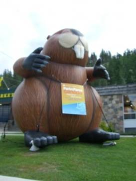
Giantic Parks Canada beaver 3D model of Kootenay NP This is a tourist town, plain and simple. For about 2 to 3 blocks the main highway is paralleled by two frontage streets. The east frontage street is lined with the Canada Parks visitor center, the small and expensive grocery store, an ice cream shop, pizza place, and gas station to name a few. The west street is also lined by a gas station, pizza place hotel, motel, and other restaurants. There are some 30 hotel/motels in this town, one commercial RV park, and the very large Redstreak Parks Canada campground.
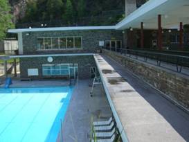
Overlooking Radium Hot Springs Services at Radium Hot Springs The Redstreak campground just happens to be up a good 400 ft on a hill over town. We headed on up and checked in. So with one very short laid back day we prepared to head into the parks. June 12 - Trail work We could go back down 500 ft to rejoin the road into the park and then climb right back up. Or we could try the trail to the hot springs and avoid the extra climb. We decided to try the trail. It really is just a hiking trail. There are stairs, switchbacks, and some steep pushes. We’re glad we did it as it was not as difficult as the road. But I wouldn’t recommend it in summer. Too many people. The trail dumped us out on thr picnic terrace overlooking one of the cooler pools. These hot springs have been in use since aboriginal times. Today there is a nice, stone faced building that houses several different pools at different temperatures. The building is quite old, probably dating from the 20s. But the pools are well maintained.
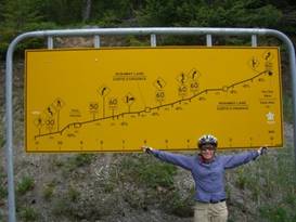
A pool at Radium Hot Springs A pool at Radium Hot Springs From where we hit the road it was still a good 6 to 7 miles to the top with sometimes 8% grades. By now we’re in good shape so it wasn’t too bad a climb. But by taking the trail we’d missed the 10% grade going through the narrow canyon.
The road grades out of Radium Hot Springs A sign showing the grades out of Radium At the crest what should we find, a bear jamb. These crazy people had stopped their cars in the middle of the traffic lane and were out of their cars running over to see the bears. Amazingly they were doing this to a mother black bear with at least one cub and the cub was on the other side of the road. Granted it is exciting to see a bear in the wild, but these people just do not realize how quickly the situation can get dangerous. If you really want to see a bear close up, you’re best to go to a zoo. Just up the road there was another, this time a grizzly. And then one more further along. It seems the bears are in high elevations this time of year. They were eating the dandelions. We carefully wound our way past the bears and cars and got away as quickly as possible. We did not want to Be around if things got ugly.
Kootenay River valley overlook Once over this pass you drop into the Kootenay river valley. This is the same river that goes south and curves around to Canal Flats. Here in this upper river valley you are surrounded be the high, rugged Rocky Mountain peaks. Simply awesome. We went only as far as McLeod Meadows Campground, another short day. None of the other campgrounds are open yet. So there wasn’t much choice. It was a lovely day and we went for a short stroll down the Dog Lake trail to enjoy the scenery. Over the Kootenay River on Dog Lake trail June 13 - Goats and paint pots
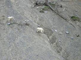
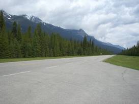
The first few miles along the Kootenay Parkway in the valley seems so much like traveling in a --- park. Actually an urban park. The trees have been removed for many yards on either side of the roadway. With mowed grass, it looks like manicured lawns. This changes once you leave the Kootenay and start climbing along the Vermilion. In many locations near the road there are salt and mineral licks. These are good places to see wildlife. In fact not too far down the road we spotted several mountain goats. They were perched precariously on the side of a cliff made from a broad road cut. They looked like they were eating the rocks. Their ability to scrabble up those cliffs is astounding. We’ve hiked up stuff like that and it’s not easy at all.
Mountain goats on road cut
Mountain goats on Kootenay parkway The Kootenay river valley is beautiful. The mountains on each side are shear rugged, glacier made peaks. The river itself is dusty colored from all the glacier silt. On and off sprinkles accompanied us to Vermilion Crossing where there is a small store and lodge. The “lodge” consists of a restaurant and about a dozen little cabins. This is the only spot where you can buy any supplies along the entire Kootenay Parkway. Kootenay Park lodge at the crossing We waited a while, just long enough for a few more showers to pass. A group of 5 not so lucky bikers pulled up. They were wringing out their gloves, squishing in their shoes. They did not look comfortable at all. We didn’t laugh or make any snide comments. We’ve been there far too many times for that.
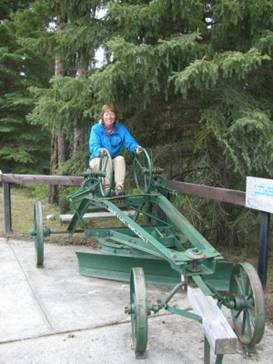
Park looking Kootenay parkway The Kootenay Parkway was originally the idea of a local entrepreneur. He thought the Kootenay River valley would make perfect apple growing country. He talked the BC government into building it. They got only 22 miles along when the money ran out. So BC came up with the idea of a road for land swap. They’d get the Canadian federal government to build the road in exchange for 5 miles of designated park on each side. Kootenay National Park was born. Unfortunately for the original entrepreneur the climate was not suited to apple trees. So his dream died. The original road wasn’t much more than a dirt track. It was finished in 1922. Over time the road was continually improved until in the 1970s the new, wide modern road was built. During that improvement they discovered some of the equipment used to build that first road. It now sits at a road side stop where you’re welcome to try it out.
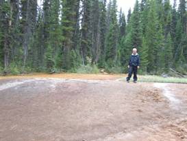
Trying out 1920s road grader Road equipment from 1920s construction Not too much further down the road is a site known as the Paint Pots and Ochre Creek. Here are springs that bubble up from a rich iron deposit. It makes the entire creek run a bright orange. Looking around the Paint Pots In ancient times the natives would come here to gather the clay for red paint pigment. They would kneed it, form it into balls, bake it, crush it into a powder, and mix it with fish oil for paint.
Brian checking out the paint pots In the 1910s and 20s a company actually collected the clay for use in commercial paint products. However, when the park was created, along with the new road, this practice was deemed incompatible with the park’s purpose. So much for those jobs. Some leftover equipment remains at the site today. We had an easy 2.5 km left to Marble Canyon campground. All right, I admit it wasn’t exactly open yet. But as that one sheriff back in Idaho said, “gates don’t mean anything to you.” June 14 - Marble canyon, cool
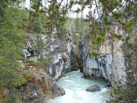
Marble Canyon
Across the road from the campground is the canyon for which it’s named, Marble Canyon. This was the third time we’ve visited and still it amazes. Although this time it had a completely altered ambience.
Outlet of Marble Canyon
Lower end of Marble Canyon
Looking over the top of Marble Canyon This used to be a forest choked with large, old trees. Decades of fire suppression resulted in an overgrown forest. In 2003 a fire hit the valley and lasted for 40 days. It burned 12% of the park, some 178 square km. It encompassed most of th Vermilion river valley including the Marble Canyon area. So now rather than a hike closed in by forests, it’s quite open giving it a whole new feel. Millions of new little trees are already springing up to replace what was lost. Results of fire at Marble Canyon Marble Canyon is an interesting geologic feature. Both Vermilion River valley and Tokumm river valley were filled with glaciers once upon a time. The Vermilion valley one was much bigger and deeper. When the glaciers receded there was a nice U shaped hanging valley left behind with the Tokumm creek running through it. At the bottom of the valley was a white limestone with a flaw, a crack. The creek worked its way into the crack slowly widening it. Over time this became the canyon. The head of the canyon is a slowly moving waterfall face. Chunks of rock fall making the canyon longer and longer. Today’s waterfall will be part of the canyon some thousand years from now. It does make for one exciting and fascinating natural feature to behold. How Marble Canyon was formed The remaining 4 1/2 miles to our first crossing of the Continental Divide for the year was not too bad. Then there we were, standing where the waters divide, some going to the Atlantic some going to the Pacific. The same sign that’s been there since we made this first climb in 1991 is still there and now looking worse for the wear. But it gets the point across. Our next valley was the Bow River valley. We hurried along trying, but not quite making it, before another squall hit. We arrived at the Castle Mountain lodge/store/gas station just somewhat damp. The Bow Valley is a major transportation corridor which is surprising considering it runs right down the middle of Banff National Park. There are train tracks, a 4 lane divided highway, and the Bow Valley scenic drive. We chose the scenic drive which has a couple good climbs. Because wildlife also uses this valley they’ve been building many critter crossing tunnels and bridges over the 4 lane highway since the 1970s. They’re still at it. There were plenty of stopping points along the scenic parkway including one that has a sign about the W.W.II internment camps. While the US put Japanese in camps, the Canadians put mostly eastern Europeans in camps. Today we think the idea is awful. But we should not reinvent history. At the end of the Parkway is the Lake Louise village. For all the years we’ve been coming here we’ve always regarded this place as one of the most expensive in Canada’s Rocky mountains. The little grocery store has exorbitant prices. Same goes for all the cafes, restaurants, and hotels. There’s no such thing as a good fast food place. The closest is Laggans Bakery where you can get a quick bite at somewhat cheaper prices. Actually as far as best value goes we’ve usually found the best prices are at the gas station/mini market. It’s well worth price comparing between the market and gas station. The Lonely Planet guide book claims the youth hostel’s cafe has the best prices in town. We’ve never found that to be the case. In the Little Samson mall there are 2 empty shops. Someone really should put in a fast food burger joint or quick pizza place. We installed ourselves in the park campground for a couple nights. One major change is they’ve now surrounded it with an electric fence. Tenting used to be almost impossible before as this area is a big hangout for female bears. With the new fence that’s all changed. You should see how excited the humans in the cage get when visited by a bear. Fun to watch.
APPENDIX A – ROUTE
June 7 - Route 93/3 to Cranbrook, 42.04 miles June 9 - Route 93 to Fort Steele, ACA Great Parks North route to Skookumchuck, 37.65 miles June 10 - Great Parks North route to Dry Gulch, 55.14 miles June 11 - Great Parks North route to Radium Hot Springs, 4.78 miles June 12 - Great Parks North route to Mcleod Meadows CG, 18.20 miles June 13 - Kootenay Parkway to Marble Canyon CG, 38.00 miles June 14 - Great Parks North route to Lake Louise, 31.04 miles
APPENDIX B – CAMPSITES, HOTELS
Currencies listed in Canadian dollars, exchange about $1.025 USD = $1 CND
June 7, 8 - Mount Baker RV Park in Cranbrook, BC ($22.18/night) June 9 - Johnson Lake Rec area (free) June 10 - Dry Gulch Provincial park ($21/night) June 11 -Redstreak Campground in Radium Hot Springs ($27.40/night) June 12 - Mcleod Meadows CG in Kootenay National Park ($21.50/night) June 13 - Marble Canyon campground in Kootenay National Park ($21.50/night) June 14 - Lake Louise Campground ($27.4/night)
REFERENCES
Adventure Cycling Association Great Parks North Route Section 2
|
|
Copyright © 1995-2011 by Caryl L. Bergeron - Distribution for personal use permitted. Distribution for other uses with written permission.
Acknowledgements
|