| Caryl and Brian's World Bike Tour |
|
Northwest Tour 2011 XII - Northeast Washington |
![]()
![]()
![]()
![]()
|
|
NORTHWEST TOUR 2011 PART XII - Northeast Washington
Vancouver, BC to Oroville, WA July 16 to July 26, 2011 Start 65,429 miles (104,686 km) cumulative: End 65,736 miles (105,178 km) cumulative
TEASERS
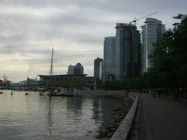
Vancouver, truly a European looking city. Escape the rain, drive to Sandpoint. Revisit Newport, WA after 23 years. Don’t forget ice cream at the Tiger Store. Stop by the rebuilt mission at Kettle Falls. Climb 4300 ft or go north? Grand Forks has 2 faces, new and old. Who were Chee Saw and Ranald MacDonald? Molson museums would be fun to visit sometime. Businesses are reviving in small town west. July 17 - Over the river, across the bridge A nice bike path leads directly from the campground to and across the Lions Gate Bridge. Views from this height extend from the sound across the city to the mountains. You can easily see that Vancouver has become a city full of high rise buildings.
Looking
at Vancouver, BC from Lions Gate Bridge
The bridge bike path drops you off at the head of the point that encompasses Stanley park. This is a densely wooded park with a central road running from the bridge to the neck of the peninsula. Around the point is a sea wall that’s been turned into a biking/hiking path. It’s so popular, in fact, the bikers have to ride one way. Many years ago we walked the entire circuit. It’s a long trek.
The city of Vancouver from the waterfront Once off the bridge we took to the water front. Here perhaps more than anywhere else we really felt like we were back in one of those European river cities.
Looking
around Vancouver, BC from the waterfront
Along the waterfront is the sea bus terminal. These are huge, flat passenger ferries that are included in your daily bus fare. They drop you near the old train station which is where you can pick up the sky tram. On weekends you can ride anywhere in the system for just $2.50 for 90 minutes. Getting loaded bikes onto and off the sky tram is a snap, at least on weekends when it’s not crowded. So rather than fight our way through this big city we took the tram and within 1/2 hour we were far on the south side. From here it was a simple ride to the border. After crossing we headed for lunch, during which time it rained of course. We had just enough time between showers to get to the Birch Bay campground. We have to admit we probably saw as much if not more sea scenery on this short ride than we did the entire run down the Sunshine Coast. Even though Birch Bay is right on the beach and it was the middle of summer there were plenty of sites. We didn’t even have to take a hiker/biker site. With all the rain people are going elsewhere. July 18 - We cry “Uncle”
After 2 1/2 months of almost daily rains we’d had enough. We rented a car in Bellingham and drove in one day to Sandpoint, Id. This would put us past the bulk of the mountains back in the rain shadow. Hopefully there we’d find summer. July 19 - Arrive Sandpoint Then again maybe
not. We arrived at Sandpoint before noon. The car was left at the airport and
we cruised on into town for lunch. As we ate a round of heavy rain rolled in.
It poured and poured for a good hour. July 20 - Restart
Today would essentially be a restart of our summer tour with, hopefully, much better weather. Supposedly there’s one day of showers coming in. But after that, SUNSHINE as far as the reports can see. Sandpoint is one pretty town. It’s turned into a bit of an artist locale over the years and the lake has been a vacation place for decades. It’s growing, however. The hotel we stayed at is located north of town in an area that seems almost like a new, separate town. The old village is still just a few blocks long. There are all the amenities you could want. But if you want to buy a house in Sandpoint, expect to pay a bundle. When we first rode through Sandpoint back in 1988 we had camped in Newport. We got up early, cruised quickly through town, and headed right into Montana in a single day. It was a foggy morning which gave the place a bit of a spooky feel. It was amazing we could ride through the panhandle of Idaho in one day. This day we just headed west right away. New to Sandpoint is a rails-to-trails project. Heading west parallel to route 2 they’ve installed a new bike trail. In fact when we visited this time they were building a new route 2 bridge over the active rail tracks and adding an extension to the bike trail. Back in 1988 bike paths were almost nonexistent. Now every time we travel we find more and more towns are adding new paths. What a change. Route 2 continues along Priest Lake and the Priest River until reaching Newport. The south side of Priest Lake is lined with some very nice looking homes. It’s so pretty we can easily see why folks would want to move here and pay a bundle to do so. About halfway to the Washington state line you pass through the town of Laclede. There are no services except for a campground. However, there is one huge lumber mill operation. This lumber mill was at this time still very active. Tree trunks were piled high with water spraying over them to keep fire danger down. Fork lifts hustled about moving logs and finished product to and fro. Activity abounded. It was so nice to see at least one lumber mill in the US is still open for business. The next town, Priest River, names itself a “progressive” lumber town. We’re not exactly sure what that’s supposed to mean. But it’s likely many of the residents are employed by the company in Laclede. Priest River has some historic old houses and businesses you can look at. But, most importantly, they have a very good supermarket and the Mudhole campground just east of town would be a real pleasant place to stay. It’s got biker sites so you don’t have to worry about it being full. One large bridge with a new bike path took us across Priest River and into the first town in Washington, Newport. For folks riding the northern tier route this would either be the last town of their first state or the first town of their last state.
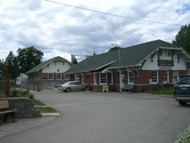
Newport, WA old 1908 train depot today
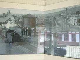
Newport’s train depots back in days gone by Newport was another town basically built by the lumber industry. Hence it’s got a pretty substantial historic center. Most of the buildings found on its main street date from the 1910s. The original town with its wooden cabins was built around the 1820s and was located closer to the river. In fact there’s a spot on the Idaho side of the bridge called Oldtown.
Historic
Newport, WA
Newport has been a rail town for a long time. For some time there were competing railroads each having their own depot. One depot was built in 1908 and the other, larger was built in 1910. The older 1908 building now houses the Newport museum and the 1910 houses the Stimson Lumber Company offices.
The two
competing train depots at Newport
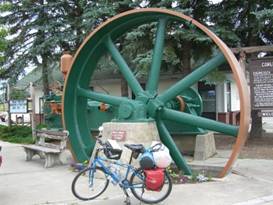
In front of the two depots is a visitor center where you can get all the information you could possibly need. Plus there’s a couple of green painted steam engines. These were used in the logging industry, of course. One has an enormous 16 ft. diameter fly wheel. This engine has since become the town’s signature symbol.
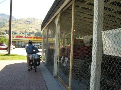
Newport’s signature steam engine Small businesses and cafes line the historic main street while the modern supermarkets and fast food places are more strategically located along the busy Route 2. We don’t recall there being the large well stocked Safeway market back in 1988. If you’re headed west this is the place to stock up on supplies as the next well appointed town is Colville. We now turned toward the north as we followed route 20 and the river. The river views are quite splendid. There are a few ups and downs along the way. Although they were nothing compared to other hills we’ve done this year. We soon passed by the corner at Usk. We didn’t head into Usk itself but we’ve heard that the cafe on that corner has fantastic chow. A few miles further we arrived at Cusick. This town consists primarily of a gas station/mini market and the county fairgrounds. The fairgrounds have camping available at a price that seems downright cheap compared to what we’ve seen in Canada. The setting is pleasant, the camping lawn quite nice. But the shower and toilets are so-so. Ah well, it’s better than nothing. Besides we had the entire place all to ourselves. I wouldn’t want to camp there in late August, though. That’s when the county fair happens. July 21 - Tiger Store There wasn’t an abundance of sunshine in the morning, but at least it wasn’t raining. The forecast did call for one more day of rain and then day after day of warm sunshine. Let’s hope. The ACA route actually follows the road to the east side of the river whereas route 20 is on the west. We’d come north off route on 20 to find camping by several miles and saw no need to backtrack. So we just continued on 20. Here the road follows closely to the river having pleasant views of the river banks and houses along the way. There’s a dam downstream which means the water is flowing very, very slowly. They like to call this a lake but it really looks more like a very wide river. At the junction of routes 31 and 20 is the mostly defunct town of Tiger. There’s not much remaining, the fire department building, a physical therapy place, a couple old cabins, and the Tiger store.
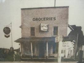
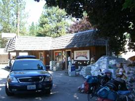
The Tiger store years ago
The store
at Tiger, junction routes 31 and 20.
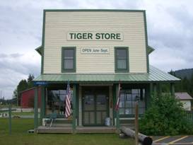
Tiger has not always been much of a town, but it has always had a store. Recently the store has undergone a complete renovation. It was moved 30 ft to make way for a wider route 2 and then placed on a more stable concrete pad. Today it houses a small visitor center, museum, plus shop. You can buy a few snacks, cold drinks, and ice cream. A peek at the top floor museum is a must.
Tiger store as it looks today From here route 20 heads west again and begins a 1300 ft climb. It’s not too steep, but after not doing too many hills recently it was slow going. The new chip seal on the road meant we were having stones flying at us as cars passed by too fast. We stopped at the very first campsite, Lake Leo. Plans for the next day are to go only as far as Kettle Falls which isn’t all that far. So there was no need to push it. Besides Lake Leo was a very pleasant place. July 22 - Furs, missionaries, miners Thunder boomed across the hills as we lay in our sleeping bags waiting. It was supposed to be clear today we kept thinking. The forecast promised. Well it did eventually clear, but not until after lunch. They’re still promising a good weekend, so we’re hoping. Route 20 going from the junction with route 31 to the town of Colville was undergoing a resurfacing just as we were riding through. What a mess. They’re using chipseal which basicly is a bunch of small rocks piled atop a layer of tar. Eventually the rocks get embedded into the tar. But when it’s freshly laid it’s not much better than riding on a dirt road. Except that here the cars go way too fast. We’d had to stop constantly to avert our faces as small stones were being flung up from those fast rotating tires. They were supposed to drive only 35 mph but they were going far faster. Fortunately the workers had only completed about 8 miles so we were off the done section pretty early in the morning. As the road progresses westward toward Colville the hills get drier and drier. While the Priest river valley seems to get a lot of rain as the air is pushed over the eastward Rocky Mountains, Colville seems to be just slightly more in the Pacific Crest Range’s shadow. Here you’ll find tall lodgepole pines and Douglas firs with very little undergrowth. The grassy hillsides turn brown in early summer. Crickets and cicades can be abundant in August. We had mostly downhill to reach the town of Colville. When we passed through here 23 years ago these towns would have had no more than medium sized grocery stores. Today Colville has a big Safeway, Super 1, and even a WalMart Supercenter. The town has grown. Even Kettle Falls, further toward the Columbia River, has a very nice size Harvest Foods. This region has seen human activity for many centuries. Kettle Falls, the falls not the town, is now under the lake. It was a great spot for catching salmon. So tribes from as far away as Montana would come here. It became a fairly major trading location.
Missionaries also came to the area. St Paul’s Mission was built right near the falls. This was a Jesuit mission that was recommended for construction by the famous Father DeSmet. It was fairly successful until small pox and gold fever took many of their converts.
Outside
St. Paul’s Mission
It continued operation as an Indian School for a while but finally closed its doors for good on August 14, 1875. The building deteriorated until 1939 when a group restored it to its original appearance. You can now visit the restored but vacant building. It’s near the eastern approach to the bridge.
St. Paul’s Mission near Kettle Falls
Inside St
Paul’s Mission
Colville and Kettle Falls today have an economy based on mostly lumber milling. There area a couple of very large active mills. One, called Boise, produces plywood. The nice Kettle Falls Campground is located right on Lake Roosevelt. It’s a big fishing and water sports locale. You can rent big houseboats to spend days exploring the coves and arms of this long skinny lake. The campground filled up on Friday night so we were glad we had arrived early. Apart from the mosquitoes, this was one of the warmest, most pleasant evenings we’d had in a long, long time.
Lake Roosevelt seen from the grounds of St. Paul’s Mission July 23 - North or west We had a choice, go west over Sherman Pass, a 4300 ft scenic climb, or head north along the river with rolling hills along the way. Tough choice. In the end we went north back toward Canada. Returning to Route 20 took us back past that Boise plywood plant. Mountainous stacks of lumber were being continually sprayed with muddy water. On weekdays there’ll be trucks lined up to add even more logs to the stack. They probably need to really stock up on raw materials in summer to allow continual operation in winter. No matter how they do it, it’s just so refreshing to see a lumber company actually surviving. At Rt 20 we turned and immediately crossed the bridge. To our surprise we found a small cafe, store, restaurant, RV park, and a maybe still open motel. We, of course, made use of the store to get a cold drink. This was going to be a hot day and we needed to keep the liquids going down.
The cafe,
store RV park at Rt 20 bridge over the Kettle River
Route 395 follows closely along the Kettle River. The river winds back and forth between the US and Canada and was at one time a logical rail road route. It’s a lovely ride with drier pine forests covering the rolling mountains on both sides. The river flows clearly and slowly. It is a big tubing river both in Canada and the US. So you’re likely to see tube toting hitch hikers trying to get rides back up river. As we cruised along this scenic road, river to our right and mountains to our left, we came to the town and store of Barstow. This is one of those places where the store is almost the entire town.
The General Store at Barstow, WA Barstow store is an old fashioned general store. It’s small, barely over 2 rooms, and it’s stuffed full of goods. There’s so much you have to be very careful as a customer not to knock things over. If anything else was added there’d be no room for clients. But you can surely find anything you need there.
The store
at Barstow, WA
A bit further down the road is Orient. This somewhat more substantial town has a correspondingly larger general store. It’s not quite so packed either. Across from the new store is the old fashioned gas station, cafe, store. It appears it’s now just used by the elderly owner(s) as a house. But the old gas pumps remain. We were wondering what could someone put in that old gas station to revive the business. Hamburger stand maybe? How about a biker bar? There must be something.
The town
of Orient, WA
A few more miles and we arrived back at the Canadian border. This ex town called Laurier used to have a gas station and liquor store. All that’s closed now. There’s just a house or two plus the border stations. In this case the Canadian station is more modern than the American. The US one only has additions for post 9/11 security. Canada route 3 is just a couple miles up the road. On the way we paused to look at the Trans Canada Trail crossing. We’ll be returning via this trail so we wanted to see what the surface is like. Hard packed dirt with crushed rock. It looks good. Going west on route 3 the trees tend to give way to a drier grassland, at least on the south facing slopes. Traffic is heavy but the shoulder is wide and in fine condition. We had only 13 miles to Grand Forks with a few rolling hills along the way. So we arrived in plenty of time to have long showers and cook a good dinner. The city park at Grand Forks also has a campground. It has large shade trees, free showers, grassy sites, and is right on the river. Normally it’s probably empty. However on this weekend they were having a big BMX race event. They have a permanent dirt BMX course as part of the park. Hence the campground was packed. We were a bit worried about late night noise. But not to fear. This group settled down plenty early. This is a young kids event so they’re not partying all night long. July 24 - Nothing open
Before leaving Grand Forks we took a cruise through town. As with so many of these western towns it’s got two parts. There’s the historic old town with its early 1900s store fronts. These are now filled by restaurants, gift shops, and offices. Then there’s the new town located out on the highway. Here are the large stores, fast food restaurants, hotels, gas stations. All these towns have 2 faces.
Old town
Grand Forks, BC
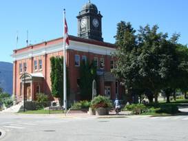
Checking out the outdoor museum at Grand Forks Old town Grand Forks is small. The original shopping street is basically one block long leading up from the river. There’s a charming brick city hall with a large black clock tower on top. The imposing brick old courthouse has been turned into a visitor center and museum. On the courthouse grounds is an old log cabin once used as a customs house in Danville. The sign says the government hired a local rancher to handle this duty. And across the street is a group of open sheds containing old carriages and vehicles. They have a beautifully restored 1929 bright red fire engine.
City hall at Grand Forks, BC We now had the option of continuing on route 3 to Osoyoos or returning to the US to take more back roads. We chose the back roads option as route 3 was rather busy. So at route 41 we headed back south. The Danville border crossing has at least one going business, gas station/minimart, plus one very picky border guard. The line was getting longer and longer as we waited in the glaring sun. He seemed to like putting everyone through their paces. We’re still trying to figure out just where they think we could store all those guns, bottles of booze, fruits and veges, prescription drugs, and other stuff. I suppose they have to ask.
Checking
out the outdoor museum at Grand Forks, BC
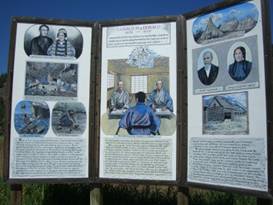
Curlew is a tiny town just south of the border. While for Canadians the southern border area is the most populated, in the us the border region seems about as remote as you can get. Hence, Curlew has not much more than a small general store, saloon, restaurant. As it happened it was Sunday around 11 AM and all 3 were closed. We’d been really looking forward to a juicy hamburger lunch. Disappointed and thinking about those hot peanut butter sandwiches we had to eat, we wandered toward the intersection south of town. Here much to our delight we found the new Tugboat’s burger stand. It’s not much, just a prefab log cabin with a few tables in front surrounded by a rock parking lot. Oh but their burgers are good. The small road headed west toward Chesaw has almost no traffic. It wanders along the flats of the Kettle River valley for about 10 miles. It was a hot sunny day and we had a strong tailwind. This was probably one of the best biking days we’d had all summer. There’s another intersection where the road headed right returns to Midway, BC via a ferry. It’s surprising they’ve never built a bridge. At this intersection stands Washington’s smallest state park. This is the grave site for a fellow named Ranald MacDonald, not Ronald McDonald. He was the son of a native Indian princess who happened to take an interest in the Japanese culture. He wanted to spend time in that country. So he signed on as a sailor. Somehow he scuttled his boat near Japan, was arrested, and spent time in a Japanese prison until he could be repatriated aboard the ship Preble. During this time he taught English to the other Japanese prisoners. Thus he became the first person to teach English in Japan. For this they made his grave a state park?
All about Ranald MacDonald We weren’t planning to return to Canada just yet so we turned off onto Toroda Creek road and then right on the road to Chesaw. Until this last right turn we’d been riding through valleys that were somewhat drier than what we’d seen further east and were filled with ranches. It was all private lands so we couldn’t stop for camping. Just about 4 miles up the road, however, we entered forest service lands and found the primitive campsite at Beaver Lake. It’s a small campsite, just 11 spots, which is actually still managed by the Forest Service. It still has the old fashioned wooden latrines plus the ubiquitous Baker hand water pump which, unfortunately, wasn’t working. In the dead of summer only 4 sites including ours were occupied. If you want to get away from summer crowds this is a great place to come.
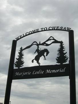
July 25 - Rodeo with attached town Rain drops were falling on our tent once again in the morning. Thunder rumbled off in the distance. Once again we were not to have that promised sunny day. We had rented the car and drove to Sandpoint with the hopes of finding summer. So far in the week since we’d started riding again we’d had 3 days of rain. We’re convinced it’s following us. Leaving the campground the road fallows alongside Beaver Lake for a bit. Then there’s a short climb to the next lake, Beth. There’s a second, larger USFS campground here that was equally empty. We’re beginning to think that a summer spent staying at these remote campsites in the RV might be a lot of fun. We then skirted the shore of Beth lake for a while before starting the more serious climbing. This is, of course, when the rain started coming down. Once again out comes the rain gear, shoe covers and all, to stay in place for the rest of the day. The climb was somewhat steep as we ascended along a narrow, winding road through a beautiful canyon. Eventually we reached the 3600 ft crest only to have to make a fast, steep descent of 500 ft to the town of Chesaw. Chesaw was named after a Chinese fellow called Chee Saw. He lived as a miner in this region with his native American wife. The town is even smaller than Curlew. It boasts 2 small general stores and one saloon. The saloon and one store are in buildings that look like they’re from the original mining rush days, old weathered board and baton buildings with the covered front porches and tall square false fronts. I’ll bet the wood is tinderbox dry and one small spark could see the demise of one or both.
The tiny
town of Chesaw, WA
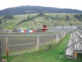
Chesaw used to be a much larger community. It had both mining and ranching as their major trades. Over time, the mining gave out and droughts caused the ranches to shrink. Many of the buildings from its heyday are gone, such as the large high school. But what does remain is the big rodeo arena.
Every July 4th Chesaw hosts an amateur only single day rodeo that must be the big event for miles around. The stands are enormous for a town this size. Camping is allowed next to the arena and a very rustic set of pit toilets are provided. It must be quite a busy place on July 4. The rest of the year the stands sit silent.
The rodeo
grounds at Chesaw, WA
Chesaw, being further west than Curlew, is further into the rain shadow of the Pacific Crest. The hills surrounding town are mostly grassy with the upper reaches covered in pine trees. Unfortunately for the town the pines are being attacked by the pine bark beetle infestation that is plaguing the entire western forest land. You can tell that these trees won’t have long to live. They already show the telltale red of first stage infestation. The smart thing to do now would be to harvest every single one and then burn the scrap so the cones can burst and new trees get started. Will they do that? Will the environmentalists let them? Probably not. So in the next year or so all the trees will die and someday soon a major fire will threaten the town. The rain began again the minute we left Chesaw and continued all the way to Oroville. We had one more climb of around 700 ft followed by one amazing 3000 ft screaming drop into the Okanagan valley. With the rain pelting down we decided to bypass going out to see the museums at Molson. With just around 32 residents, Molson is an official ghost town. In 1901 there was an attempt to build a railroad from Spokane to Vancouver going through Molson. Molson grew to become a major train support town with all the trappings of a large town. But the rail never reached Vancouver. A competing line was built running up the much easier Okanagan valley making the route through Molson obsolete. Today Molson has turned itself into a museum town. They’ve moved in several buildings from the surrounding area plus put a lot of artifacts into the substantial old brick school house. Someday we’d love to come up to see this, in our RV of course. What a ride downhill. It was raining the entire way and those raindrops do sting when you’re flying at 25 to 30 mph. the lower we went the drier the environment. There’s even sage brush in this almost desert environment. This dry land extends a little up into BC which the Canadians proudly proclaim is their little desert. Folks in Washington aren’t that impressed. The Okanagan valley is a major fruit capital. This is where those famous Washington apples are grown, not to mention cherries, pears, peaches, and other tree growing fruits. Naturally the valley would be a skinny strip of green along the river surrounded by brown desert. But irrigation has turned it into a valley wide oasis of greenery. We swung into Oroville and promptly called up weather.com to see what was going on with all the rain. Satellite imagery showed a single blotch of rain located just over the Okanagan valley. The valleys to the east and west were clear. This rain burst was creeping gradually northward right along the valley and was expected to last until 1 AM. We took a hotel for the night. July 26 - Nothing much happening
We’ve noticed an interesting trend. In many of these northern western towns, the little burgs that are quite remote, there are old family run businesses that have been falling into disrepair. Often they’re run by an elderly couple who started up early in their youth. Their kids grow up and leave these small towns for the more exciting cities. Over time the couple loses the energy and enthusiasm to keep things running well. The business slowly dies. Today we’re seeing a lot of these old businesses being renovated, reinvgorated, and put back to work. Often it’s middle aged folks who’ve done well in high paying, high stress, big city jobs who just got sick of the rat race who are buying them up. We’ve seen it at the hotel in Lima Montana, the store in Dell, Montana, and the motel in Oroville. It’s great to see. Although it emphasizes the fact that many folks are now fleeing the cities for the quiet small town life. We can sympathize with that sentiment. Time for a day off. So with the rain once again past, hopefully for a long time, we moved over to the Osoyoos lake park campground to spend a day just relaxing. Osoyoos Lake Park was originally a community park. It was then turned over to the state park system in 1953 only to be recently returned to the city. Truly it doesn’t make sense for this little park to be run by the state. We wonder if a lot of parks in a lot of different states shouldn’t be turned over to the local community especially in light of the fiscal mess many states are in. This park was definitely a nice quiet place to spend a relaxing afternoon.
APPENDIX A – ROUTE
July 17 - Across Lions Gate bridge, Waterfront to sea bus station. Took sky train to King George station. King George st and hwy 99A to border, back streets to Birch Bay state park, 32.34 miles July 18 - Back roads to Bellingham, WS. Hertz rental car to Sandpoint, ID, 21.94 miles July 20 - Route 2 to Newport, SR 20 to Cusick, 50.58 miles July 21 - Route 20 past Tiger to Lake Leo, 36.59 miles July 22 - Route 20 thru Colville to Kettle Falls, 43.28 miles July 23 - Route 395 to Canada border, Route 3 to Grand Forks, 47.20 miles July 24 - Rt 3 to Rt 41 to Danville border crossing. Rt 21 to Curlew, Kettle River Rd to Toroda Rd to road to Chesaw, to Beaver Lake, 39.51 miles July 25 - Road past Chesaw to Oroville, WA, 30.23 miles
APPENDIX B – CAMPSITES, HOTELS
Campsites in Canada prices stated in Canadian dollars at a rate about $1.058 USD per $1 CND
July 17 - Birch Bay SP, Washington ($12/night, $.50/shower) July 18 - Apple Tree Motel in Spokane ($62.70) July 19 - Guesthouse Lodge in Sandpoint, ID ($84.78) July 20 - Pend Orielle County Fairgrounds in Cusick, WA ($10/night) July 21 - Lake Leo USFS CG ($16/night) July 22 - Kettle Falls USFS CG ($10/night) July 23 - Grand Falls, BC City Park ($17.92/night) July 24 - Beaver Lake USFS CG ($8/night) July 25 - Motel Camaray in Oroville, WA ($65/night)
REFERENCES
|
|
Copyright © 1995-2011 by Caryl L. Bergeron - Distribution for personal use permitted. Distribution for other uses with written permission.
Acknowledgements
|