| Caryl and Brian's World Bike Tour |
|
Northwest Tour 2011 XV - Great Divide Mountain Bike Route 1 |
![]()
![]()
![]()
![]()
|
|
Northwest Tour 2011 XV - Great Divide Mountain Bike Route 1 NORTHWEST TOUR 2011 PART XV - Great Divide Mountain Bike Route 1
Banff National Park, AB to Whitefish, MT August 12 to August 20, 2011 Start 66,359 miles (106,174 km) cumulative: End 66,686 miles (106,698 km) cumulative
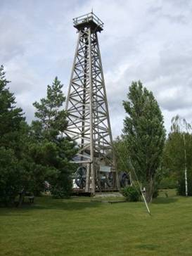
BCs last standing wood oil rig found at Fernie
TEASERS
Banff grows more crowded every time we visit. If you can’t take Goat Creek trail it’s a hard climb to Spray Lakes. Still crowded campgrounds in south Alberta. Elk Pass is incredibly tough on a bike. Huge mining operations support Elkford. Want to see the world’s largest truck? Imagine losing your entire purse by the side of the road. Back to Eureka, a nice town to layover at. On the GDMBR to Whitefish for the third time. Frost already! August 12 - Skip Banff Early morning on the Bow valley parkway is quiet. The toists have as yet to rouse and get on the road. It was just us and the truck working on the new road pavement for most of the way. Only when we approached Banff did we see traffic. The early bird gets the best ride. We’ve been to Banff town a few times before. Even on our first visit we found it too over crowded with tourists. Now it’s gotten even worse. The number of huge tourist lodges has grown like crazy. On summer days the main shopping street is packed. Crowds throng everywhere. This is not what we go to a National park to see. We just checked at the parks information center to learn the Goat Creek trail we were planning to ride is flooded. So we’d have to detour through Canmore. We later learned that the trail is flooded because they’re replacing the generators on Spray Lakes Dam. They want to save the water so it’s backed up over the trail. There was no reason to shop for food in Banff since we’d be going through Canmore anyway. So we picked up the new Legacy Bike trail at the south side of town. This new paved trail goes as far as the park gate, 4 km short of Canmore. It has big fencing and electrical rubber pads to keep wildlife off the highways and trail. It’s a very popular trail seeing 30 bikers/hour in high season. Although it was all downhill to Canmore which meant all that more to climb to get back on route. Above Canmore to the west you can see a diagonal cut climbing the hill. This is the Spray Lakes road and our destination.
What a steep, steep climb. It’s loose rock and dirt, really dusty, and tough climbing. We climbed about 1200 ft in just 2 miles, about a 12% grade. By the time we got to the top we were drenched in sweat and just about beat. Yet we still had about 8 miles or so to the campsite. It was Friday. Campsites were filling fast. We grabbed the first one we found and called it a day.
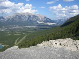
Fabulous
views at West Spray Lakes Campground
Aug 13 - Bumpy road
Spray Lakes and Smith Dorrien roads pass through a region that seems to be a local’s secret. While the mountains don’t have all the visible glaciers, you can see the carved peaks leftover from the glaciers everywhere. It’s magnificent scenery the entire way. Even a stop at a picnic area can have breathtaking vistas.
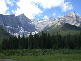
View along Spray Lakes Road
Fabulous
views at the Sawmill picnic area
Unfortunately this also means tons of cars on weekends. Some folks were kind enough to slow down. Most, however, barreled through at the 80 kph speed limit. Dust and rocks were thrown up at us for each passing car. It’s a road with great scenery but with all the traffic and the rocks and dust we’re not so sure we’d recommend it for bikes, at least not on a sunny August weekend. After that climb to Spray Lakes we weren’t so sure we were up to the climb to Elk Pass this day. We hoped to camp at one of the sites in the Peter Lougheed Prov Park. Stopping at the visitor information center we were told all campgrounds were full, there’s no hiker/biker site, and no wild camping in the park. We’d have to go over the pass. Not a particularly enlightened policy. I was tempted to tell the girl that if I couldn’t get over that pass today I’d be camping wherever my legs happened to finally give out. I didn’t though. Resigned to going over we stopped at the Boulton Campground to pick up water. It just happened the camp manager from the nearby walk-in campground was also there. He told us that in fact there were 3 open sites. We gave him our name and he drove back to hold one till we could get there. But he also told us that the Boulton Campground does have 2 “emergency” sites for just the situation where hikers or bikers are in a fix. They should make that better known. In any event we could at least wait till morning before tackling Elk Pass. Aug 14 - What a pusher!
Today would have us climbing over Elk Pass. The road is incredibly steep, a pusher. So we got an early start to get up the hill before it got hot. It was a chilly morning. Even still we were shucking our jackets only part way up the hill. It was about an additional 800 ft climb to the pass with an extra 200 ft down and up. Almost a mile of that was pushing, Brian in front me in back.
At the top of Elk Pass Once at the top there was another incredibly steep downhill for probably a good 2 miles or more. We concluded that going north to south on this pass is probably the easiest. Later that day as we headed toward Elkford we passed another biker who had rear bags, front bags, plus a BOB trailer. We had to wonder how he would ever manage that upcoming climb. There’s not a chance either of us could have done it with that kind of load by ourselves.
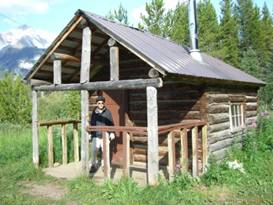
Cabin at the Tobermory recreation site There are a few recreation sites along the way including a most unique cabin. The Tobermory cabin has 2 bunk beds with new mattresses, a sink, kitchen utensils, a wood stove, plus broom and whisk pan for you to clean up. You can stay the night which would be particularly nice on a rainy day. Many a biker is now taking advantage of this little spot.
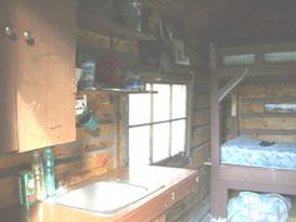
Inside the Tobermory cabin The elevation profile in the Adventure Cycling Map shows a continual downhill run all the way to Elkford. Not so. There are numerous steep ups and downs along this dirt road. By the time we arrived in Elkford we were really getting pooped. We can see why this 50 mile section is normally recommended for 2 days rather than one. If you’re headed north, definitely 2 days would be needed as there’s far more climbing. Elkford and Sparwood further down valley are both big mining towns. To the east of the road you can see where the huge mine seems to be decapitating the mountain top. It’s coal they’re extracting and they’ve been doing it for years. The ladys at the Elkford grocery store say that you have a choice of 2 jobs in town, the store or the mines. Neither of them wanted to work in the mine.
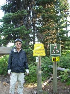
What you
find in Elkford BC
The Elkford municipal campground is run by the Lion’s Club. It is mostly used by folks on temporary assignment to the mine or logging industry. The tent sites are located in the trees and are quite small. Fortunately for us we were the only tenters. Showers are free, a rarity in Canada, but the bathrooms aren’t especially clean and there was a fair amount of litter around. This park could use some better care. But having that nice grocery store right across the street was wonderful. Aug 15 - Tonka truck lover’s dream
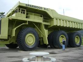
After cruising 19 miles downhill into a stiff headwind we arrived at the next mining town, Sparwood. They’re very proud of their mining history. They’ve taken some of the large underground coal mining equipment and scattered them around town with plaques describing their use. They no longer do underground mining. Rather they’re stripping the top of the mountain off. It’s safer and less costly. The town’s biggest pride and joy is the giant truck. This Titan 33-19 was the largest truck in the world. It says on the sign that you can carry 300 kids to a party, you supply the ice cream. This dump truck was used until around the late 1970s. Nowadays they have smaller trucks that have similar carrying capacity. So this huge Tonak truck now sits as a tourist attraction for the town.
The world’s largest truck at Sparwood Sparwood was founded in 1965. It’s a brand new town. So you’re not going to find those quaint old mining town fronts. But those big pieces of mining equipment are worth the stop.
The
world’s largest truck, the Titan 33-19 found in Sparwood, BC
It started to rain while we sat in the Sparwood mall snacking on ice cream sandwiches. In about an hour it stopped with a dry window looking just long enough for us to hustle to Fernie. As we road along the rough shoulder Brian came to a sudden stop. “Wasn’t that a purse?” he said. Much to our surprise it was. Beside the road was an open purse. Credit cards and business cards were scattered all over and there were even more cards inside the purse pockets. We gathered up what we could find and turned the whole thing over to the Fernie visitor center to take care of. Someone is going to be mighty surprised to get that back. We have to admit we’ve seen some strange things on the side of the road this summer, wrenches, scissors, screwdrivers, a phone, not to mention this complete purse. The supposed RV park in Fernie was just not acceptable for tenting. So we hurried down to the Mount Fernie provincial park and grabbed one of the few remaining sites for the night. Aug 16 - Back in US to stay
Our last day in Canada has come at last. We had about 15 miles to get to the store at Elko. The folks in this little market are some of the friendliest around. With a quick lunch under our belts we turned off the very busy route 3 and headed south on route 93. When we passed over the Elk River for the final time we closed the loop we started back in June. At Grasmere we spent all but a dime of our Canadian currency on a cold drink and cherry twizzlers. In 8 more miles we were back at the US border again. It’s sad to see the old single man border station now replaced with the ridiculous 3 lane, super electronics covered station that is now manned by at least 6 people. You do wonder, does it really make a difference?
Returning
to the US at Roosville, MT
In no time we were sitting in the brand new Eureka market enjoying a huge fried chicken dinner. It’s so nice to be back in the US where prices are so much cheaper. Aug 17 - Ahhhh Eureka Eureka is such a comfortable town for bikers. The town park costs just $5 per night. It’s got a large grassy lawn that gets watered at 9AM and you can set your tent anyplace you want. Showers are included.
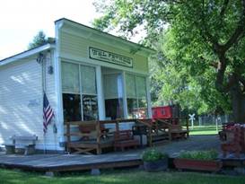
The general store at Eureka’s museum There’s a nice museum across from the campsites where they’ve placed a bunch of old buildings from around the valley. It’s quite well done. The park seems to always have all sorts of activities. One year a religious group was doing a concert with a free chicken dinner. When they asked us if we wanted free food, we just couldn’t say no. This time there was a small farmer’s market going on. We sat and watched folks perusing all the goods on the 7 or 8 tables. Funny how farmer’s markets seems to sell almost anything except farm goods these days. Yup we like Eureka. It’s just the perfect size and has the perfect amenities for a layover day. Aug 18 - Lady trader
The large diesel truck started at 6AM again. Guess it was time to get up. The city park may be quiet for camping at night but you’d better be prepared for an early morning wake-up. Before leaving we wandered over to look at museum to see if much has changed. Most of the buildings were moved from a town that was flooded when Lake Koocanusa was formed. There are a couple churches, train depot, old forest service fire ranger’s cabin, a general store, community center, and Eureka’s first log cabin. All date from early 1900s.
Looking
around the buildings of Eureka’s museum
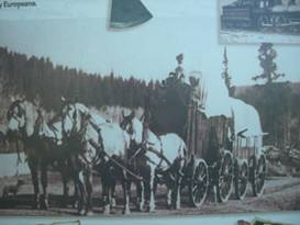
One new addition is a sign talking about Sophie Morigeau. She was a granddaughter of one of the men who accompanied David Thompson on his journeys. She, like her grandfather, became a trader and because she was part Indian she could cross reservation boundaries freely. Imagine a lady trader back when women didn’t get to be in a man’s world often.
Sophie and her trading wagon caravan
Information
sign about the woman trader Sophie Morigeau
We rode south on Rt 3 to Grave Creek Rd rather than taking the GDMBR’s more roundabout path. We turned left to climb over the pass along Grave Creek. This unusual name for a creek came about during the gold rush era of the 1860s. There were rumors of a big strike across the creek. So men flocked to the area only to be stopped by raging waters. Along came one big fellow on a horse who declared he’d get across or die trying. He entered the water. To the alarm of the onlookers the horse lost its footing and the big fellow went down. They found his body and buried him nearby. Hence the name Grave Creek. It’s a reasonable climb until the last 4 to 5 miles. Then it gets very steep and rocky. Once over there’s just a minor drop to the Tuchuck campground. Amazingly this is still a free campground. You just need to treat water from nearby creek. Aug 19 - I remember this climb
This is the third time we’ve ridden this route. By taking this round about path from Eureka to Whitefish you more than double the distance and add a lot of rough dirt roads. You could ride from Eureka to Whitefish on the highway in one day. By the dirt route it takes 3. Temperatures were at freezing when we got up. It’s mid August and that’s what you can get this far north near such high mountains. The road that Tuchuck campground is on seems to have deteriorated over the years. Perhaps it’s just getting more traffic. Or maybe since the fire took out the surrounding trees on the lower road there’s not enough moisture to keep the road solid. No matter what we had a bumpy downhill ride. Route 486 is as we recall, not good at all. It’s rocky, dusty, and can have a lot of traffic. This will probably be our last time biking this road and we won’t miss it. Red Meadow road on the other hand is actually not bad. It’s surface is far more solid than the other two roads with fewer rocky sections. It does get very, very steep for the last 3 miles to the pass making for a tough grunt. But the pretty Red Meadow campsite at the top is worth the effort.
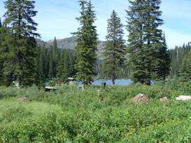
The view of Red Meadow Lake from our campsite
Pretty
Red Meadow Lake
We were surprised to find the campsites full and a bunch of fishermen around the lake. Every other time we’ve been here we were pretty much alone. It’s a Friday evening on a nice August day. Everybody’s out camping. Aug 20 - Frrrrost!!!!! It is cold at Red Meadow Lake. Overnight the temperatures plunged below freezing. In the morning there was frost on the table, tent, grass. Even a small spot of water turned to ice. It made crawling out of the tent in the morning a real chore. But town was our next stop with food, showers, ahhh civilization. From the lake there is just a short .5 miles or so climb and then a lot of downhill. Road conditions varied from loose dirt, bumpy rocks, to easy sailing hardpacked. No matter it was still a fast run down to Whitefish Lake. Once on pavement you start passing some absolutely gorgeous houses right on the lakeshore. At least if you buy a home here you don’t have to worry about tides washing it away as you do on the Pacific coast. As we find with most lakeside roads it’s not flat. There are several good climbs until you finally get to the last wide road into town. We immediately went looking for ice cold drinks to wash all that dust out of our mouths. We didn’t have much summer weather before. We certainly found it now.
APPENDIX A – ROUTE Aug 12 - Bow valley parkway to Banff, Legacy bike trail to park gate, Route 1 to Canmore, Spray Lakes Road to Spray Lake, 44.23 miles Aug 13 - Spray Lakes road to Smith Dorrien road to Kananaskis Trail Rd to Peter Lougheed Prov Park, 38.49 Miles Aug 14 - Elk Pass trail over Elk Pass, Elk River FS road to Elkford, 48.85 miles Aug 15 - Route 43 to Sparwood, Route 3 to Fernie, 43.95 miles Aug 16 - Route 3 to Elko, route 93 to Roosville, Airport Rd to Rt 93 to Eureka, MT, 52.08 miles Aug 18 - Route 3 to Grave Creek Rd to Tuchuck campground, 31.33 miles Aug 19 - Grave Creek Rd to route 486 to Red Meadow Rd to Red Meadow lake, 29.93 miles Aug 20 - Red Meadow road to Lower Whitefish lake to Whitefish, 31.20 miles APPENDIX B – CAMPSITES, HOTELS Campsites in Canada prices stated in Canadian dollars at a rate about $1.01 USD per $1 CND Aug 12 - Spray Lakes West Campground ($23.00/night) Aug 13 - Mt. Sarrial campground ($23/night) Aug 14 - Elkford Municipal Campground ($20/night) Aug 15 - Mount Fernie Prov Park ($21/night) Aug 16, 17 - Eureka, MT city park ($5/night) Aug 18 - Tuchuck campground Flathead NF ($0/night) Aug 19 - Red Meadow Lake CG ($0/night) Aug 20 - Whitefish RV park ($26.16/night) REFERENCES
|
|
Copyright © 1995-2011 by Caryl L. Bergeron - Distribution for personal use permitted. Distribution for other uses with written permission.
Acknowledgements
|