| Caryl and Brian's World Bike Tour |
|
Northwest Tour 2011 XVII - Idaho, Wyoming |
![]()
![]()
![]()
![]()
|
|
NORTHWEST TOUR 2011 PART XVII - Idaho, Wyoming
Macks Inn, ID to Lander, WY August 21 to September 6, 2011 Start 67,030 miles (107,248 km) cumulative: End 67,276 miles (107,642 km) cumulative
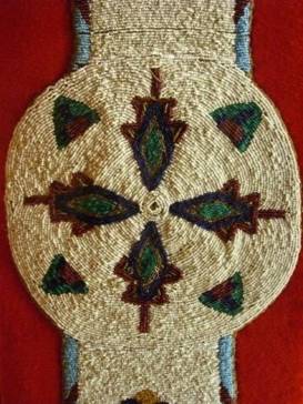
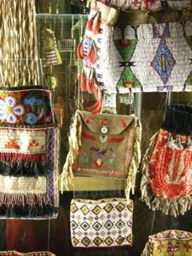
Blanket strip covered with seed beads
TEASERS
Those Tetons are so unreal looking The new Indian Art exhibit in Colter Bay is awesome So
much construction over Togwotee pass goes on for years what exactly is a jackalope? Wind River reservation combines Arapahoe and Shoshone Lander, a nice town for a break
August 31 - Friendly Ashton
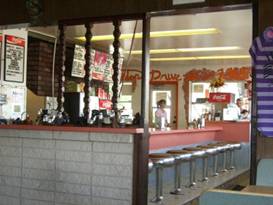
We had a quick ride to Ashton during which another tire blew out. We are beginning to wonder what’s gotten into these Kenda tires this year. Our next concern was, where do we find a new replacement tire? The first thing we did when we arrived at Ashton was to head for the Frosttop diner. This little café has been an Ashton staple since 1965. It still has carside service, a counter with round rotating stools, and a giant root beer mug sign out front that's been rotating since the café first opened. They make great burgers and we always stop in for one whenever we come this way.
The Frosttop diner at Ashton
The one
and original Frosttop diner with its rotating root bear mug
Then we wandered over to the local grocery store for ice cream and more cold drinks. While sitting at the grocery store’s deli there were a couple local good ole boys in the next booth making the usual jabs and jibes at each other. We were soon pulled into the give and take. One fellow, a driver for FedEx, had to get back to work. So we were left with the very entertaining Jimmy. Before we knew it we were sitting in the back seats of Jimmy’s truck headed to Rexburg in search of a replacement spare tire. Rexburg is a good 20 miles or so further south. With the price of gas these days we were stunned that someone would offer to drive us both ways. And Jimmy wasn’t even planning a shopping trip that day. This is Mormon country and one thing we’ve found, the more religious folks tend to be the most helpful. With the long delay spent fetching that tire we didn’t have time to go too much farther. We just rode to a nearby golf course that has a sort of campground. The map says it’s supposed to be .5 miles off route. It’s actually 1.6 miles to the actual campsites. Also, it’s primitive camping, vault toilet and water only. We’d been hoping for something nicer with a shower. Well it was too late to go on to find a wild campsite in the forest, so we took it. But, it just didn’t seem quite worth it. Sept 1 - Back road to Teton
The weather reports we had heard said something about high winds. We’d ridden into the golf course under very heavy winds and we did not want to have to fight against them again as we headed back to the route. So we got up bright and early once again. Fortunately once on route the winds were in our favor, for a change. Tourists know that to enter Teton National Park you either come from Dubois to the east, Jackson Hole to the south, or from Yellowstone to the north. For those in the know, however, there’s another route.
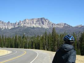
Leaving out of Ashton is what’s known as the Reclamation Road. This dirt track was built by the Bureau of Reclamation to build and maintain Grassy Lake reservoir. The road starts as a good, wide gravel route and gradually turns to a narrow, rocky dirt road. This road passes right between Yellowstone and Grand Teton coming to the pavement in Roosevelt Parkway right at Flagg Ranch. There’s no entrance gate via this route.
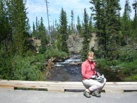
Riding
along the reclamation road between Yellowstone and Grand Teton National Parks
We remembered the road being really rough. It seemed so tough we weren’t able to finish it in one day. Now maybe we’ve grown more accustomed to rough, dirt roads or it has been improved over the years. This time it didn’t seem quite so bad. Actually the road starts rough but gradually improves. You climb slowly to the shoulder of the Teton Range at an elevation around 7400 ft then drop to 6800 ft at Flagg Ranch. Naturally it’s not just a single up and then down. It’s a pretty ride through some relatively lush forests with only a small section having been burned recently.
At a
pretty river along the reclamation road south of Yellowstone National Park
Once inside the Roosevelt parkway you pass 8 drive-in campsites. These are small areas, usually 1 or 2 individual sites, and have nice maintained latrines. The only thing missing is water. Best yet they’re free and first come first served. You just may need a more rugged vehicle to get to the ones beyond number 4. We hadn’t had a shower in 5 days and it was past due. So we stayed at Flagg Ranch campground. This is one of the most expensive campgrounds we know of for tents. We only stay here when hiking or biking and when it’s hard to go elsewhere.
Flagg
Ranch resort and RV Park
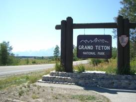
Sept 2 - Pretty beads When you leave Flagg Ranch headed south you have just one major climb and then a good drop to Jackson Lake. Here you travel along the lake for many miles until the junction to Colter Bay. There are great views over the lake to the mountains. Even though glacier carved mountains are common especially in BC, the Tetons just appear unusually surreal.
View over Lake Jackson to the unreal Teton mountains
Views of
the Grand Tetons over Jackson Lake
The morning temperatures started out really cold, less than 30. So we took our time getting up and going, Once on the road things warmed up pretty quickly. So by the time we got to Colter Bay visitor center it was a nice, toasty day.
This is
the Colter Bay visitor Center
We haven’t been to the Colter Bay visitor center in many years. Since our last visit they’ve added a large Indian Art exhibit. These are artifacts donated by a local collector. Many of the pieces are priceless.
Bead decorated mens’ mirror bags In one display case there were 3 blanket strips that were absolutely covered in seed bead decoration.
A
wonderful beaded blanket strip at the Colter visitor center in Grand Teton NP
There is also a huge collection of moccasins, mens’ mirror bags, medicine bags, pipes, pipe bags, and other items. The objects come from groups all across the continent and all seem to have a lot of beading. There were a few quill work pieces as well. But these never are as numerous.
Massive
collection of moccasins at the Colter Bay Indian Art museum
We veered off at Moran Junction to head east to Dubois getting one last look at those unreal looking Teton mountains before heading over a rise and losing sight of them.
One last
look at the Teton Mountain range
Leaving the Grand Teton National Park The road continued past the Buffalo river which looked remarkably tame. Last time we saw this river during our 2008 CDT hike in July, it was a raging torrent. At least this time you could probably ford it on foot. We opted to stop at the last forest service campground before starting the climb over Togwotee pass. There was construction for 8 miles ahead and we’d rather do the climb fresh in the morning. Sept 3 - Cold It was another very cold night and happened to be our 28th Anniversary. So we treated ourselves to breakfast out for a change. The road going over Togwotee pass has been undergoing a major rebuild for years. This year there was 8 miles torn up near Moran Junction and another several miles at the pass. This is where they literally are tearing down the mountainside to make room for the wider road. It’s a pain while it’s being done. But the final road is very nice. They still have several more years to go to get the whole road rebuilt. It is a long climb to Togwotee pass. The elevation gain is about 2800 ft. Once at the top it seems like you’re going through the pass for miles. It’s a beautiful pass filled with meadows and creeks. Springtime probably sees a plethora of flowers. When the downhill finally starts you are treated to views of the Absaroka mountains to the north. These hoodoo looking ridges are less well known as the Wind River range. They’re drier and not as difficult for hiking. Someday we’ll go exploring there.
The Absoraka mountain range near Togwotee Pass
The
Absaroka mountains northwest of Dubois
Part way down the hill not too far from Dubois is the tall Tie Hack memorial. In winter men would go into the forests around Dubois to fell the trees and cut rail ties. In spring the ties were floated down the Wind River to Riverton where they’d be shipped outward. Tie hacks were paid by the piece and good ones got better pay than other types of railroad workers.
Memorial
to the tie hacks west of Dubois
There’s not much call for tie hacks anymore, but Dubois remembers them fondly. After Union pass road the scenery gets more deserty. The red striped Painted hills to the north of the road are quite something. The red striped hoodoos add great colorful interest to the area. We rolled into Dubois. This is another town that is strung out for over a mile along the highway. There is a small area that’d you call the center. But for the most part it’s a line of businesses on a single main drag. Sept 4 - Another church stay Wyoming is famous for the jackalope. This strange creature looks an awful lot like a giant jackrabbit with antelope antlers in between it’s huge floppy ears. Different towns in Wyoming claim to have been the original place of “discovery”, but Douglas is likely the culprit. They say this critter is very good at mimicking human voices and has been known to host sing alongs to the lonely cowboys out on the range.
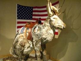
That’s one big jackalope In Dubois you can have the rare opportunity to have your photo taken with one of the largest jackalopes known to mankind, stuffed of course. I particularly like the realistic inclusion of jackalope turds.
One huge
Jackalope at the Dubois Exxon
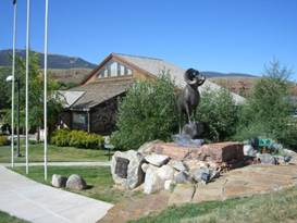
There’s more to see in Dubois than just a giant Jackalope. They have a very nice little museum and the National Bighorn Sheep Center. The hills around Dubois play host to the largest Bighorn Sheep herd in the Rocky Mountains. Bighorn sheep lovers have built this beautiful center that talks about all things bighorn.
The National Bighorn Sheep Center
Outside
the National Bighorn Sheep Center
The Dubois museum has several small log buildings that have been moved to the site. One log house was originally used by the Lumber and Tie company Inside they have a good display on what the tie hacks were, what they did, and how they eventually became obsolete.
Display
on the tie hacks at the Dubois museum
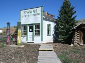
There’s the usual old one room log school house, a pioneer cabin, and an old service station. We liked all the old Wyoming license plates nailed to the wall of the service station. They’ve had the cowboy on that plate for a long, long time. Out back there are a bunch of pieces of farm equipment plus an unusual mini fire engine made from a jeep. It’s actually a pretty good museum.
The service station in the Dubois museum
A Willeys
jeep turned fire truck at the Dubois museum
Downtown Dubois is a short strip of board and baton buildings all designed to the old western style. Many are actually new buildings but they have a building code requiring wood construction. They want to keep that western style going.
Looking
around downtown Dubois
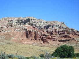
The ride down the Wind River beyond Dubois goes past spectacular red and white striped hoodoos for many more miles. Eventually the terrain flattens and gets even drier. The unique hoodoos end replaced with sandy looking cliffs overlooking the river.
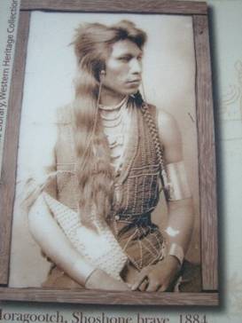
The remarkable red striped hoodoos near Dubois Soon we entered the Wind River Indian Reservation. This Rez, as the residents call them, has Shoshone combined with Arapahoe. The shoshone were represented by a wonderful chief named Washakie. He was so well respected by the US government that his group were the only natives given the opportunity to choose where they wished to have their reservation.
One handsome Shoshone brave Later the government added the Arapahoe. The Arapahoe had fought hard to keep their traditional lands and way of life. By the time they were subdued there were very few left. The government moved them to the Shoshone reservation supposedly on a temporary basis until a reservation of their own could be found. Not only do the Arapahoe speak a different language and have a different culture they were often enemies of the Shoshone. Putting them together like that seems like a very bad idea. Today the Arapahoe and Shoshone still live on the same reservation. They hold separate areas, have separate governments, and basically live completely apart. They do interact for issues that cross boundaries. There’s a small town on the Rez named Crowheart. It is named after Crowheart butte. The butte was so named because a Shoshone chief placed the heart of a Crow on his spear following a big battle in which the Shoshone were victorious. At Crowheart there is a small store/gas station. It’s one of those places where if you look hard enough you’ll find just about anything you’re looking for, except for a kitty litter box as the owner told us.
The
Crowheart store/gas station
Across the street is the fire station and down the road is the local church. The church is unlocked and bikers sometimes spend the night. We ended up sleeping on the floor. Sept 5 - Time for a layover Riding from Crowheart to Lander involves a short climb out of the Wind River valley and then a bunch of ups and downs as the road runs across the mountain foothills. We could see glimpses of the the Wind River range to the west. We made one short stop to get drinks and a second stop at the casino just before Lander. Getting to Lander was nice. Lander is a pleasant town with plenty of shopping, motels, and restaurants. A perfect place to celebrate our anniversary. APPENDIX A – ROUTE
Aug 31 - Route 20 to Ashton, Cave Falls Rd to golf course, 44.64 miles Sept 1 - Reclamation road to Flagg Ranch, 40.43 miles Sept 2 - Route 287/191/89 to Moran Jct, Route 287/26 to Hatchet campground, 35.98 miles Sept 3 - Route 287/26 to Dubois, 47.72 miles Sept 4 - Route 287/26 to Crowheart, 32.33 miles Sept 5 - Route 287/26 to Lander 44.16 miles
APPENDIX B – CAMPSITES, HOTELS
Aug 31 - Timberland Golf & RV Park at Ashton, ID ($15/night) Sept 1 - Flagg Ranch RV Park ($37.80/night) Sept 2 - Hatchet Campground, Teton National Forest ($10/night) Sept 3 - Dubois KOA ($27.58/night) Sept 4 - Crowheart church ($0/night) Sept 5 - Maverick motel ($58.79/night) Sept 6 - Holiday Lodge Motel and Camping ($10/person/night)
REFERENCES
|
|
Copyright © 1995-2011 by Caryl L. Bergeron - Distribution for personal use permitted. Distribution for other uses with written permission.
Acknowledgements
|