| Caryl and Brian's World Bike Tour |
|
South America West Coast II (Chile) |
![]()
![]()
![]()
![]()
|
|
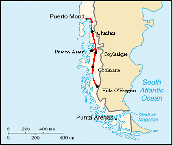
SOUTH AMERICA WEST ADVENTURE PART 2 Puerto Montt, Chile to Villa O'Higgins, Chile December 29, 2001 to February 1, 2002 36,301 miles (58,550 km) start, 37,043 miles (59,747 km) end cumulative
Teasers:
|
| Stock up in Puerto Montt to begin the famous Carratera Austral. | |
| You are going to visit el senor Tompkins, right? | |
| Ferries in Chile are unusual to say the least. | |
| Just you try to finish that mound of seafood. | |
| Stray cows make great private rodeo shows. | |
| Enough Chilean ferries. At least the glacier was wonderful. | |
| Is it Jasper, B.C. or Coihaique, Chile | |
| One last 100 km of pavement, it's on to Cochrane. | |
| What's there to do in Cochrane besides fix bikes, buy food, and eat. | |
| Finally, easier riding on the Carratera. | |
| It's the current end of the road, Villa O'Higgins. Now to get out. |
"There are two kinds of adventurers: those who go truly hoping to find adventure and those who go secretly hoping they won't."
William Least Heat Moon (William Trogden), Blue Highways: A Journey into America (1983)
Looking at a map of the string bean Chile, one can see that about 1/3 of its southern coast is a ragged edge of fiords, islands, and bays. This raggedness is caused by the sea having invaded the inland central valley, flooding all the low lands that would normally have been lakes surrounded by low hills. Puerto Montt it located right at the top of this ragged edge along the shores of the bay called Seno Reloncavi. If you were to turn right, west, at the T in the highway, Ruta 5 would take you down the length of the Grand Isla de Chiloe, the first spot in Chile that Magellan visited. Chiloe is a large elongated island of low hills, small fishing villages, and lots of farms. On the other hand, if you turn left, east, you'll begin the trek down the 1200 km long, mostly unpaved Carratera Austral. Along this coast there are rugged mountains and cliffs that drop to the sea, hanging glaciers, rain forests, and wilderness. Some of the most spectacular scenery in all Chile. We came to the T intersection, looked right, looked left, and made our decision, not a tough one at that. Left we go.
Puerto Montt was founded on February 12, 1853 by Vincente Perez Rosales. Eventually it became a major transportation hub with ships arriving from Europe bearing goods and emigrants. Originally goods were transported overland to the Lago Llanquihue and then by barge across the lake. Later the railroad was added. Today the large 4 lane divided highway continues the tradition. It's the capital of Chile's 10th region and sports a population of just over 130,000. In addition to its port activities, it provides services for many surrounding communities and has many manufacturing plants located on its outskirts.
Since the city was founded after Chilean independence and because many of its early citizens were from Germany, the old part of town has more the feel of a central European village rather than Spanish. Primary streets follow the contours of the Seno Reloncavi and the surrounding hills. The plaza, located toward the western edge of town, seems more of an after thought rather than the primary center of the city. Even the buildings don't quite look Spanish.
It's a very pleasant town in which to spend a few days. Clearly an affluent community, it contains not just one, but two high quality shopping malls and many upscale stores, restaurants, and hotels. The entire length of the seno is lined with a nice park which even includes a short bike path. Puerto Montt's citizens also have an interesting sense of humor, Their nativity scene, placed under a huge scaffolding Christmas tree that you can climb on, has the traditional figures dressed in modern style clothes. Joseph dressed in denim jeans and a plaid shirt was just too amusing.
Just to the west of the town center is the ferry port and the cute fishing village of Angelmo. Rows of short, multicolored wooden buildings house all sorts of shops displaying local crafts. There are woolen goods, wooden wares, lots of leather, and unusual strings of red colored barnacle innards that you eat. They look a little like the strings of dried chili peppers sold in New Mexico. Brian took advantage of the opportunity to purchase a nice, handmade leather belt for a bargain $6. The main reason for us to visit Angelmo, aside from just wandering, was the sea food. We partook of an absolutely wonderful salmon dinner. After spending this time in a place of plenty it sure will be tough to head off to where stores and restaurants are a scarcity. Yet, the scenery should more than make up for it. It's on to the Carratera Austral.
The Longitudinal Carratera Austral was originally the brainchild of General Pinochet. Territories in the southern Chilean region had been under continual contention between Argentina and Chile ever since independence of both countries. In fact, the last bit of border dispute was just resolved through negotiation in 1999. Consequently, Pinochet had a persistent fear that he could lose the southern lands if he didn't do something.
That something was to initiate the construction of a road connecting the southern extremities with Puerto Montt. His idea seemed to follow the "use it or lose it" mode. He felt that to ensure Chile's claim to the land he had to have established settlements throughout the south. Settlements needed easy access to the rest of Chile in order to exist and thrive. Hence the need for the road.
Although started in the 1970s the road has actually not been entirely completed. Just within past two years a new extension was added to connect Puerto Yungay with Villa O'Higgins to the south and another now connects Caleta Puelche to Cochamo. Ferries are still used to connect some of the sections and will probably never be replaced. Additionally, original plans called for the road to connect all the way to Puerto Natales. There are still plans to complete this section using a series of 13 ferries crossing between the coastal islands south of Villa O'Higgins. The overland route is virtually impossible due to the huge southern ice sheet. Eventually there will likely be an Argentina road that connects to Villa O'Higgins. In the meantime, it's simply the end of the Carratera. The Carratera is mostly dirt. Yet gradually parts are being paved. In 2001/2002 there was approximately 240 km of paved road extending both north and south of Coyhaique, the largest town on the road. Chile is agressively pushing to complete pavement all the way from Puerto Montt to Villa O'Higgins within 10 years.
Although intended to solidify Chile's claim to the southwest side of the continent, the road has probably done more to give Argentines easier access. while access from Chile requires the use of one or more different ferry crossings, many roads coming directly from Argentina's Patagonia region already exist. Some are even paved. But this does allow for lots of Argentine tourists to easily flock over to Chile.
Options for riding the Carratera Austral include taking a ferry from Puerto Montt to Chaiten and then heading south or just riding directly out of Puerto Montt. The riding option is only available in summer. A small 1/2 hour ferry taking cars, and bikers, from La Arena to Caleta Puelche across the estuary Reloncavi runs year round. However, the second ferry that leaves from Hornopiren and arrives in Caleta Gonzalo only runs in summer. This year it began operation on January 2 and finished on March 15.
Our timing was just about perfect. Having waited in Puerto Montt an extra day while a cold front complete with driving rain passed by, we finally headed out on the famous carratera on January 1. It was one quiet morning to be leaving. Surprisingly, all shops were closed. They hadn't been shut on Christmas, yet for New Years day they were. Go figure. If anything I would have thought it'd be the other way around. We passed only a few people in Pelluco who seemed to still be celebrating and then just odds and ends of folks along the road. Traffic was incredibly light especially once the pavement ended. What traffic there was seemed to consist of mostly red pick-up trucks. Yup, apart from one white and one green truck, every pick-up truck we saw this first day out was red.
Weather reports had claimed that this day was supposed to be mostly cloudy. They said nothing about rain. Of course, it rained. On the one hand, the rain did pack down the dusty road giving it a much smoother feel. Although, things did get muddy and wet. We did get lucky. Sporadically spaced at just about every house is a covered bus stop. Some professionally made steel structures. Others just interesting homemade shelters. It didn't matter to us. They provided a dry spot out of the rain which is all we wanted. Rushing from shelter to shelter, we somehow managed to get through the day with only getting a little bit wet. Not bad considering what a wet and rainy coast this is.
Whereas campsites were too hard to find along the central valley, here there were just too many great spots to pass up. Our first night was spent quietly on a small hillside overlooking a picturesque fishing camp with fabulous views of the Seno Reloncavi. In the distance we could watch the little ferry from La Arena chug its was back and forth across the estuary about once every 1 1/4 hours. Sunset was WOW! The next day just a mere 33 km into the ride we spotted a perfect grassy field sitting next to a clear flowing river. Dense jungle like vegetation clung from the rocky cliff on the opposite bank. It felt too soon to stop, but we just couldn't resist. Geez if this keeps up we'll never get to Villa O'Higgins, at least not before the snow flies.
"Are you going to see senor Tompkins?" the question came again and again. "Just who is senor Tompkins?" I asked. Evidently Tompkins was the original creator of the Esprit clothing line now turned environmentalist. After cashing out of the Esprit line, he took some of his new found wealth and started buying huge chunks of Chilean land. Eventually he amassed a total of some 270,000 hectares located around Hornopiren and Chaiten. His aim was to turn the area into a reserve. His efforts haven't been without controversy, however. Logging companies would love to get their hands on the property and the Chilean national park service CONAF has not been able to take over the land because they lack the funds to manage it. So senor Tompkins has been working to turn it into a more or less private reserve open to the public. Anyway, it seems that virtually everyone in southern Chile has heard about Tompkins and his new park. So are we going to visit Senor Tompkins' new park? We will at least be going through it.
Cresting one more hill, rounding one more corner, and we were at last treated to some amazingly spectacular views. We'd heard that the upper section of the Carratera Austral, from Puerto Montt to Chaiten, had not only some of the roughest road conditions, but some of the most spectacular scenery. As far as road conditions go, we'd have to wait to finish the entire route before we could make judgement. Scenery, on the other hand, was as advertised. The little town of Rio Negro de Hornopiren, now just called Hornopiren or Rio Negro, sits on one of the many inlets formed by the inland sea. It is virtually surrounded by rocky crags covered in lush rain forest vegetation and topped off by bits of snowy crowns. The water is an amazing aquamarine that looks exactly like the glacier flour filled lakes of British Columbia. In fact, the entire spectacle reminded us of Lake Louise or perhaps Haines, Alaska.
Adding just a bit more quaintness to the vista is the cute town with its little wooden church, nicely landscaped plaza, and little wooden houses. We could see where a lot of the prefabricated houses we'd seen being built along Ruta 5 wind up. Tiny wooden fishing boats painted white and blue or orange and yellow lay high and dry on the shore during low tide. High tide floats boats that previously looked permanently beached. The little boats are used as water taxis by the folks living on the opposite side of the bay. They bobbed violently like corks, yet the passengers and crew carried on. No sea-sickness among this bunch. Flocks of strange white sea birds float like clouds over the water. We couldn't quite figure out what kind of bird they were. They looked like gulls, yet they made virtually no noise. Everyone knows just how raucous seagulls can be. There are some places in this world that are just "special" in our memories. Hornopiren will be one of these.
Transmarchilay runs the short distance ferries that provide necessary connections along the northern portion of the Carratera Austral. One leaves from Hornopiren, travels around a large peninsula, and reconnects with the carratera about 60 km north of Chaiten. As far as ferry boats go, Transmarchilay and Navimag (the more long distance service provider) have got to have the strangest looking ferry boats we've ever seen. They have a long, low open deck hull on which the cars sit. It is painted a bright orange. In back is a high tower full of windows and painted white, the passenger compartment. Compared to the ferries of Greece, Washington, or any other place we've been, these seem just too little or short. Certainly they're not the big, white floating castles that we're used to
These boats actually did not start life as ferries. They were originally cargo boats, which explains their unusual shape. People had started paying for passage on the cargo ships a while back. So after a while an enterprising company bought a bunch of old cargo liners, modified the interiors to carry lots of passengers, and began a regular ferry service. However, it's easy to see that these modified boats make for less than efficient car ferries. At 4 PM the town seems to gather around the ferry ramp to watch the spectacle of unloading and reloading. Unloading goes without a hitch. Loading, however, is quite an entertainment. Due to the nature of these modified boats, there is only one way on and one way off. Cars have to either turn around on the boat or back down the ramp, driver's choice. I guess if you really feel confident about your backing skills, the second option is best. Additionally, the ferry does not really dock. At least, it's not tied to anything. It simply pulls up to the boat launching ramp, at an angle no less, drops it's car ramp, and revs its engine to stay in place. Every now and then it has to reposition as the incoming or outgoing tide changes the water level. Much to our amazement it took well over 1/2 hour to load at most 20 cars. Several times they had to pull one car off, move another over, and try once again to squeeze in the extra two that showed up late. The motorcycles were on and off at least 3 times. A Washington state ferry would have had that number of cars loaded in 10 minutes flat. But, hey it just wouldn't be quite as entertaining if they did things differently.
Well, we'd have to say that the five hour ferry ride from Hornopiren to Caleta Gonzalo was not exactly one of the most enjoyable. The passenger compartment in this old, modified freighter is itsy, bitsy. At most 30 passengers could fit comfortably at the 4 or 5 available tables. We wound up spending most of the time either on the roof or, when it got cold and windy, huddled behind the main cabin. Fortunately the weather was absolutely perfect so spending the time outside wasn't so bad after all. We just couldn't imagine how crowded the passenger compartment would be if it were raining. Also, much to our absolute amazement there was absolutely no food or drink service. The chef on board prepares meals only for the crew. We wound up dining on a gourmet meal of peanut butter, crackers, cookies, and dried apricots. If this is the best they can offer for a 5 hour ferry, we're really wondering how the 4 day ride from Puerto Natales to Puerto Montt is.
We had left Hornopiren fairly promptly at 4 PM and pulled into Caleta Gonzalo at around 9:30, dusk. Thankfully, there is a campground located right at the ferry terminal. Being just a couple of weeks past the longest day, we had plenty of time to set up camp before total darkness.
In the light of the perfect morning we were able to see just what kind of place we had entered. Caleta Gonzalo is located right in that special reserve that Senor Tompkins has created. Consequently there is virtually no development in the area. It's an absolutely pristine rain forest and one very dense forest at that. There are tall trees with impenetrable undergrowth all around. Camping would be impossible if there weren't cleared sites. Hiking along anything but a river or one of the established trails would be impossible. Everything is big; trees, bushes, ferns, bugs. One plant in particular caught our attention. If I were to stand next to one with my arms outstretched to the sides, a single leaf of this bush would be just as wide as my outstretched arms. We had to hike several of the trails along the road just to experience the magnificence of this amazing place.
So our luck with the good weather just had to come to an end and when it rains along this section of the Carratera Austral, it pours. It is a rain forest after all. It started on our second day after the ferry with a gentle sprinkle. We stayed put for one more day in the thankfully covered campsite Cascades. The next day rain came down in moving sheets. We had to go on as food was running low. After around 40 km riding, 5 hours, and multiple drenching down pours we arrived at the not too tempting camping Arayene. Everything was soggy, pants, shirts, socks, hair, bags. A hotel seemed far more tempting. I scanned the camping. Squish, squish, squish my shoes smucked through the extremely soggy ground. Water stood up to 6 inches in some spots. A hotel seemed even more inviting all the time.
The one truly inviting feature of the campground was the nice, dry, enclosed common room. Nestled inside were Anna, Americo, and their son and daughter. Up from Coihaique for their vacation, they promptly invited us to essentially move in, bikes, tent, and all. They already had a nice fire going and even offered some sweetened mate, bread, and wonderful homemade jam. Well, with all this how could we possibly head for a hotel. Move in we did and after a hot shower to top it off the world seemed a whole lot better.
Chaiten is a town of approximately 3500 people nestled along the shore of this southern inside passage. It has a regular rectangular street pattern running about 9 blocks along the bay shore and 5 blocks deep. Houses come in a vast variety ranging from tiny, boxes covered in brightly panted wood siding to rambling structures covered in gray weathered wood siding. It has just about everything one could possibly need: gas station, lots of small stores, hotels and hospedajes, restaurants, hardware stores, laundrymat, even internet access. Perhaps the one thing missing is some way for a foreign visitor to get cash using a credit card.
Surprisingly, this is the first reasonable sized town we've visited in our 6 years of touring where we couldn't use our credit card despite the fact there's a bank with an ATM. The Banco del Estado de Chile is an old throwback to the Allende days when the banking system was nationalized. Today even though it has lots of competition, it still retains its old ways. It's solely an internal bank having essentially no ties to the rest of the world. Its computers don't talk to any other bank or external central system. As far as we can tell, there aren't even plans to change this arrangement. If I were a Chilean living in any other town than Chaiten where there is only one bank, I would certainly not choose the Banco del Estado. Fortunately, we always carry an emergency stash of dollars just in case and that's one thing this bank will do, exchange U.S. dollars. Don't try Euros as yet.
Just imagine you're getting ready to spend about a week out in an area where the only stores you'll see will be spaced about every other day apart and will be about the size of a small Am/PM or 7 eleven minimart. Now imagine you're in the only town of reasonable size anywhere near and have to stock up on supplies. Chaiten has about 6 "supermercados" so you just might think "Simple, just go to the grocery store and stock up." Not so fast. These are not your U.S. style supermarkets, no not even close. Each one is about the size of an overgrown minimarket, each one has a few items that meet our needs, each one has a few different items. It took all day for us to go from store to store to store, buying one item here, two there, another couple over there. It's certainly not particularly efficient, but you do get to know the entire town.
Before leaving Chaiten we just had to have our first try at a specialty called curanto. Descriptions we'd seen in our guide books led us to believe this would be a thick stew of various mullosks, chicken, potato, ham, and sausage. Thinking this would be a reasonable sized stew we ordered 2, one for each of us. We were a bit hesitant at first, the whopping price of $3000 pesos, or about $4.50 US, caused us some concern. This is a very high price for a Chilean meal. But, when it arrived we were absolutely stunned. Precariously balanced on a platter about 12 inches long and 8 inches wide was this absolutely huge mound of clams, muscles, oysters and other mollusks I've never seen before, a piece of chicken, a big slab of some potato pancake, some other odd gelatin thing, a huge chunk of ham, a small piece of sausage, and one large boiled red potato. It was a small mountain of seafood mounded to overflowing on the plate. I looked at this concoction, wondering where to even begin, chose one muscle looking thing, and dug in. Gradually the pile of full shells shrank while the pile of expended grew. Half an hour later I was passing bits off to Brian. We both rolled out of the restaurant so entirely stuffed we couldn't even contemplate dessert. Curanto is not what we had expected. It is far, far more. We can only recommend that if you happen to be in Chaiten, make sure to find the Cocineria Marita Estrella and order up. However, unless you are totally famished, you'd better share.
Once again having a full set of panniers and very heavy bikes to boot, we took off. It was a sunny morning and we'd already learned the hard way, when the sun shines you ride. The road south of Chaiten proved to be dramatically better than that to the north. In fact, even the first 12 km are now paved. Beyond the pavement, the dirt is a very nice often quite smooth hard packed dirt. Only a few spots have rough loose rocks, washboard, or major pot holes. We were able to maintain a remarkable average speed considering it was a dirt road. We climbed gradually for about the first 60 km and then grunted up a very steep grade for the last 8 km up to the pass. With an elevation of only around 650 m this is actually the highest pass along the entire Carratera. The Andes certainly are significantly lower at these latitudes.
The further inland the road went, the more spectacular the scenery became. Snow levels at this latitude are extraordinarily low and glaciers abound. We oohed and ahhed around every corner as another icy blue glacier came into view. The Icefields Parkway in Canada may have its share of glaciers. But we'd have to say that this Carratera far more than exceeds that road. An added benefit, there's almost no traffic, plenty of free camping, stunning scenery, lots of water, sufficient supply points. This is bicycle touring at its absolute finest. Now we can see why so many bikers come to Chile.
"Are you changing the road? Is it going to be asphalt?" I'd stopped to ask the survey crew we spotted at the pass what they were doing. Since the Carratera's inception in 1978 it has gradually gone from an extremely rough dirt road, to an improved dirt road, and now is slowly being paved. Since the time our Chilean automobile club maps were printed an additional 40 km around Coihaique were paved and 12 km south of Chaiten. Now it looks like they will soon be paving another 68 km taking the asphalt over the pass and on into the town of Villa Santa Lucia. This section is expected to be completed in 3 years. Eventually the entire Carratera will be paved and we can only imagine what that will do to the wildness of the region. Farmers and ranchers will move in, fences will go up, forests will be clear cut. We can only hope that the lure of the tourist dollar will entice the government into preserving more land. Yet based on their reaction to Senior Tompkins' private reserve efforts, it's unlikely. This is a good time to be riding down here as it will only change more rapidly over the next few decades.
We finally started seeing other bike tourists headed north. After traveling so long down the Carratera Austral without seeing nary a one, we'd begun to wonder about all these reports of the many cyclists spotted every day. First to cross our path were two Swiss cyclists riding full suspensioned bikes and towing B.O.B. trailers, all the latest regalia. They were on a year long journey that included riding bikes in North America and Chile, sending the bikes back to Switzerland, and then continuing on to Australia where they plan to buy a car with which to see the west coast. From there we're not sure where they go. It was quite evident that their living budget was generous as they were staying in hotels or hospedajes every night and the cost of shipping bikes back to Switzerland has got to be enormous. They didn't look like the wild camping type. Unfortunately for us they had not come through Villa O'Higgins. So we were not able to get the information we desired.
Our next biker was a German who looked to be even more heavily loaded than us. He had started in Ushuaia, but also skipped Villa O'Higgins. We're still hoping to find someone who came that way. That night as we set up camp and cooked dinner we were passed by no less than 2 loaded tourists and about 15 sagged tourists. So now we were beginning to believe that this truly is a bicycling Mecca, at least this Carratera Austral is.
There comes a point where no matter how much you wish to go on, your body simply won't. That's how we both felt the two nights we spent in the wild between Chaiten and Puyuhuapi. The first night was due to the incredibly steep climb up to the pass. For a full 8 km we crawled at an excruciatingly slow pace up grades that must have been well over 10%. When we finally made camp just after the top, neither of us could go another inch. The next day was just about the same. Although there was no pass to climb, the road between the tiny town of Villa Santa Lucia and the tiny town of La Junta undulated up and down at alarmingly steep grades. You'd bounce your way down one steep grade, dumping all your momentum when you hit the loose rock at the bottom of the hill, then start up another short, but steep grade. We finally had to make camp in the first feasible spot simply because we could go no further. I recall being completely exhausted on the Great Divide Mountain Bike Route, but I don't recall being quite this exhausted. The Carratera does live up to its reputation as one tough ride.
Villa Santa Lucia, a town of perhaps only a few hundred, is located about 74 km south along the Carratera. It sits in a narrow valley carved out by one of the many rivers flowing through this area and is surrounded by stunning views all around. It's main reason to exist is to support the little military unit housed there. I suppose the purpose of the military base is solely to maintain a Chilean governmental presence so that Argentina cannot stake a claim to the region. The town lines the main road and has just one parallel street. It does happen to have a few itsy, bitsy stores from which you can buy bread, tinned goods, and a few other necessities.
Located over 70 km further south and nestled in an open valley is the next small town, La Junta. The town got its name because it sits at the juncture of the Rio Palena and Rio Quinto and at the end of the Lago Rosselot. La Junta essentially means the juncture. For a town having just a couple hundred inhabitants, La Junta has a surprising variety of services; several restaurants, a well stocked market at the gas station, even some very nice accommodations. Like most towns in this area, it is mainly comprised of a mish-mash of compact little houses strung out along the main carratera and two more or less parallel streets. People are friendly and the children especially curious about our overloaded bikes.
Thankfully the third somewhat large town, Puyuhuapi, is located only another 47 km further south along a road that has far fewer nauseatingly steep hills. It didn't matter as we were already so tired from the previous 2 days tough riding that each hill still felt as though it was vertical. Established in 1935 by German immigrants, Puerto Puyuhuapi was one of the first towns established along the future Carratera. It really was a port, it's location on one of the many arms jutting out from the inside passage gave it direct boat access to the more established town of Puerto Montt. In its early days it would have provided a supply port for the more remote estancias and even La Junta further inland. Today Puyuhuapi provides a great base for exploring the surrounding Parque Nacional Queulat.
National parks within this region of Chile seem to be intended to be more wilderness preserves rather than the type of park we are accustomed to in the U.S. There are some trails, not a lot, which yield limited access to the incredibly dense and wild forests. Attempting to blaze your own trail across this land would likely find you totally lost and waist deep in some unforgiving bog. If there hadn't been a big sign over the road indicating we'd entered the park, I think we still would have been able to tell we'd just entered a wild area. Outside the park much of the surrounding landscape seems more open and there are even small farms and ranches along the road. Within the park the choking vegetation crowds up against the road. Only shear determination and brute force keep it from being swallowed up by the wild. It's in interesting area. We just wish hiking access were a bit easier.
Road construction determined our distance. Locals will excitedly tell you about how by 2005 the entire route from Villa Amanguales to Puyuhuapi will be paved. Yet for now, sections can be a real mess. For summer 2002 the road section between km 158 and 151 was closed every weekday between 9 AM to 2 PM. Rumors along the cycling circuit said that some bikers got through, some did not. The absolute last thing we wanted to do was sit out on the road for 5 hours enduring the dusty environment of a construction zone. We pushed on well beyond being tired just to be sure we got past the construction before setting up camp for the night. As it turned out, we were well glad we did. This is not just a simple paving job they're doing. They are completely rebuilding the road which includes tearing down sides of mountains to increase the road width, filling in valleys with the leftover debris. Since it had been raining the day before, the entire construction zone was a muddy bog. To be trying to ride through the mess while large earth moving trucks moved about would have been a nightmare. Nope, despite being irritable, tired, hungry, and thirsty after an excessive 77 km on this road, we were so glad we'd grunted on. I can only imagine the mess will continue to grow as the year for the final pavement draws near.
Villa Amanguales is a cute, one street town laid out in a high mountain valley. It's lucky as it gets to have its street paved along with the main Carratera. Although when we passed, the street had been dug a full meter deep to prepare for the road bed. They also are getting a new town park. Not bad considering it's population totals about 150, that's it. You can stay in one of the three little hospedajes, eat lunch in one of the three hospedajes, get food at the surprisingly well supplied tiny market, or even find fresh bread at the tire repair place. We wondered what the locals do for entertainment. We tourists take photos of the cute little church.
That evening we pushed our way to just beyond the soon to be most northern terminus of pavement, passing over what has to be the roughest section of dirt we'd seen so far along Ruta 7. Our campsite would prove to be another one of those most memorable. We found it just by crossing over the river using a narrow wooden suspension bridge. The site came complete with flat, comfy grass, a wide flowing river that was not full of frigid glacier meltwater, fantastic scenery all around, and our own private rodeo show. A cowboy was forced to show off his roping skills when an errant cow slipped its rope and ran for freedom. His horse thudded along the river bank, he yelped and swung his rope overhead, and quickly had the cows horns back in the knot. The unhappy cow still did not want to cooperate. It ran up and down the river bank trying to get away. All the while the cowboy tried to direct it with just the rope as the two cow dogs nipped at the cows hind legs. Finally, the cow was forced across the bridge and all disappeared off to the ranch. Fortunately, due to the cowboy's deft handling, neither tent nor bikes were trampled in the fray.
Pavement has finally overtaken the town of Manihuales and is rapidly extending seven km even further north. After so many itty-bitty towns, Manihuales seemed almost like a city, a long skinny city spread out just along the main highway. It has a good supply of stores, restaurants, and hospedajes. We only stopped to get a coke.
After so many miles and days of rough dirt, pavement sure can feel good. Yet, true to our luck, just as soon as we hit pavement we also got headwinds. The weather was great, total sunshine, and as far as we can tell when the sun shines the wind blows up from the south, or off the water which is the same thing here. Once again we pushed on. Our goal, get to Puerto Aisen in time to catch the ferry out to the Laguna San Rafael. We had little time to spare.
The paved road from Manihuales winds down a narrow canyon, passing over bridges spanning narrow gorges sliced out of the bedrock. Winds absolutely rip up this canyon. Further downstream the river flows into a wide valley built up by millennia of silting from the Rio Aisen. It looks like very fertile land, yet we only saw a few scattered herds of cows. Finally, Puerto Aisen comes into view. At first it's the small rodeo stadium on the outskirts of town, then clusters of squat houses, the spires of Chile's longest suspension bridge, the town's one and only stop light, and finally the main shopping street. We'd arrived with time to spare.
Maybe we hadn't had to hurry quite so much after all. Tickets in the reclining chairs aboard the Evangalistas were easy to come by. This would mean we'd be spending two nights sitting up in bus style pullman seats, but at least we got on. So we now had nearly 2 entire days to explore. We started with a bus trip up to Coihaique just to "check out" the place and find out what we could about Villa O'Higgins and the road further south.
Of all the towns and all the cities we've seen throughout Latin America, Coihaique has to be the one we feel we could actually live in. That's because it's the most like a U.S. mountain town. We could easily compare it to Missoula, Montana. It is modern, affluent, has plenty of services, is surrounded by fabulous mountain landscape, has just the right number of inhabitants, is clean and neat, and as an added bonus is within just an hour's drive to the sea and ferry service to the rest of the country and continent. Hiking, biking, rafting, canoeing, skiing, and all sorts of other outdoor opportunities abound. It has a definite upscale atmosphere. How many other Latin American towns have a climbing wall in their plaza that you can try for a few hundred pesos? None that we know of.
Most of Coihaique is situated to the northeast of its unusual hexagonal shaped plaza. To the west along the road to Puerto Aisen is a small military base and a street lined with expensive houses. Shopping lies along the streets radiating from and paralleling the plaza streets. To our absolute delight there are no less than two huge supermarkets. After the long shopping tours spent going from store to store or the short trips grabbing anything that would work in the tiny stores, it would be a real treat to do some serious food shopping here. But, that would be later. For now our real aim was to get information on what lay further south.
Coihaique has a Sernatur office manned by the most amazingly helpful lady named Gabriel. To anyone traveling north to south, the town of Villa O'Higgins is an enigma, veiled in rumors of uncertainty and guesses. The only thing we knew for certain was that the road to the town is finished and two other couples we know were able to pass from O'Higgins into Argentina successfully, one by hiring horses and the other by building a raft. The problem with Villa O'Higgins is it lies at the end of the road on the shore of the lake of the same name. Roads continuing to Argentina exist only on the opposite sides of the lake. When our friends passed through, two years previously, the road had just been completed and tourist infrastructure had yet to develop. There was perhaps one residencial, only one free campsite with no toilet facilities, and no regular boat service to the other side of the lake. A real frontier town. We wanted to know more.
Fortunately for us a lady named Gabriela manned the tourist office at Coihaique the day we visited. One question about Villa O'Higgins and she was able to produce a brochure which indicated that there are now a whole lot more services available, another piece of paper listing the days and schedules for the official boat that now crosses the lake, schedules for the bus that now serves the town, the name of a fellow in Villa O'Higgins who can help us determine what road conditions are like across the lake, and she even called the Carabineros to find out about getting our border stamps. Villa O'Higgins appears to have actually made it to the world of tourist attractions. Exactly how much of what she told us is correct remains to be seen. The Coihaique tourist office was definitely worth the stop.
We had one additional day to kill in Puerto Aisen as our boat left at 7 PM. There's not a whole lot to Puerto Aisen despite being a town that now numbers around 20,000. It's a town with a split personality. On the one hand there's the very nice plaza, nice homes near the plaza, a good riverside park that is being expanded, theater, a nice library, large gym, nice public offices, and one very nice building for the carabineros. On the other hand, there's an unusual amount of litter for a Chilean town, many drunks hanging around, obnoxious teenagers, many run down houses. Is it a town that is improving or going downhill? We prefer to think it's improving but just has a way to go still. One thing for sure, it's not a town we'd want to spend much more time in. Our plans were laid to head on to Coihaique just as soon as our boat returned.
Laguna San Rafael is poised at the end of a long arm of the sea extending into the coastline. It's most significant feature is the incredibly fantastic glacier arm of the northern Chilean ice field. This icy finger extends down from the ice field to dribble its tip into the laguna, sending flecks of icebergs floating throughout the laguna. As with Glacier Bay in Alaska, boat trips to the laguna are a major tourist attraction. Trips can be made by a few hour flight, a day long catamaran, or a 36 hour ferry. Since the ferry was the cheapest and as we weren't exactly in a hurry, we chose the ferry.
Fog lay over the boat like a dense blanket. Vision was virtually nonexistent. Even the shore, a few meters away, lay buried in gray. The ship eased forward through floating blue blobs of ice drifting along the slow current of the laguna. Gentle thuds resounded up from the hull as the ship pushed aside those in its path. Overhead the sky seemed bright even blue, yet at ground level gray persisted. We stood up on deck, waiting, hoping. Would the fog clear or were we destined to see only a massive gray block of ice. Finally the fog parted and for a few brief moments we caught our first glimpse of the incredible glacier tumbling in frozen motion down to the laguna and into the water. A massive river of broken ice colored that perfect ice blue glinted brightly in this instant of sunshine. Appropriately evocative music played from the ship's speakers. As abruptly as it was uncovered, the glacier was again enshrouded in fog leaving only its impression on our minds and in our camera.
We were fortunate that the fog did not remain all day. Three small boats were dispatched from the larger ferry each carrying around 35 passengers. In three trips they would take us up to just in front of the face of the glacier for a much closer look. The first group was unlucky, fog persisted. The second had some fog that produced an eerie effect. For us, the third group, all fog had gone. It was simply spectacular. We floated at the front of the wall of ice watching chunks calve off, producing that unique thundering noise and waves that gently bobbed our little boat up and down. We floated among crowds of floating ice cubes the sound seeming much like a huge punch bowl in which we were the floating pineapple ring. We partied, toasting each other with whisky poured over 10,000 year old ice and chanting "she she she lay lay lay, she she she lay lay lay, Chile Chile, Viva Chile" a patriotic cry given by Chileans whenever they gather. To this point we've flown over glaciers, landed on ice fields, walked on glaciers and ice fields, stood at the base of glaciers and now we can say we've floated in front of a glacier and tasted glacial ice. I don't think there's much else you can do with a glacier.
While the laguna was fantastic, the ferry itself can only be classified as a once in a lifetime experience. I do mean you really will want to only do it once and no more. The equipment in use seems to dictate an incredibly inefficient and uncomfortable situation. Docking, unloading, and loading at Chacabuco took about 2 hours to complete and this was with only about 7 or so trucks being removed and just a few cars. Passengers are loaded using an elevator that normally lifts the cars up to the second level auto deck. I've never felt more like a head of cattle being herded into a truck headed for slaughter than I did standing on that platform. Accommodations in the ferry consist of 2 levels filled with bus style pullman seats and just a few cabins, one extremely small cafeteria and one tiny bar. There are two levels that are open which provide a place to get away from the crowds in good weather. However, in foul weather these boats can be downright claustrophobic. Movies are shown in the bus seat rooms until 1 AM and the usual backpacker crowd complete with lots of booze and the requisite guitar means that there'll be no quiet for early sleepers.
Even getting on and off the little boats was an adventure. During the second trip something that lifts the platform at the back of the ferry used to get the boats in and out broke. The platform lay straight down in the water. Not deterred, the crew scrambled around and after about an hour wait they had rigged a set of stairs down the side of the ferry which we used to get to our little boat trip. After all the tours were done, it took them another 2 hours to get the rear platform functioning well enough to board the little boats and get underway. We watched with great amusement. I could never imagine Greece, Washington, Japan or any other country in which we've taken ferries even considering using such unsuitable equipment. Yet, here in Chile they take it all in stride. It was a great trip to the laguna, well worth the time and money. But, it did convince us that there is no way we want to take another long distance ferry in Chile.
Upon returning to Puerto Aisen in the wee hours of the morning, we grabbed food for lunch, retrieved our stored bikes, and headed on to Coihaique. It was only a 67 km ride on pavement with one fairly heafty climb so we didn't expect it to take too long. That was until we met the Austrian coming from the other direction. He was cruising on down the hill aboard a very old road bike sporting only rear panniers and a pile of bags on the back. We stopped to ask our usual question, "Did you come through Villa O'Higgins?" and for the first time the answer was "Yes!" At last we could find out what is down there. His journey seemed to involve riding up a nice hardpacked dirt road out of El Chalten in Argentina to Lago Desierto. He then got real lucky, a military transport boat just happened to be headed to the opposite side of the lake just when he arrived. The boat was permitted to take bikes but not civilian passengers. So his bike got a ride and he walked the 3 to 4 hours along the lake. Without the boat he would have had to push his bike along the lake which takes two days. Argentina passport control is located on the other side of the lake. He then had to push his bike to from Lago Desierto to Lago O'Higgins to await the commercial transport from Villa O'Higgins. This boat was running every Saturday in January. In Villa O'Higgins he found Chilean passport control. So it all sounded fairly straight forward. Fortunately we got a copy of the transport schedule and could time our arrival in O'Higgins accordingly. The big question is, will we be successful in following his track in reverse. We're ready to give it a go.
Coihaique is a great place to make repairs, get food, definitely get money, eat, eat, and eat. It is certainly a crossroads where bike tourists and backpackers gather and take a rest. An inspection of my bike revealed a broken spoke on the rear wheel. Brian's bike had a bolt missing from one of his chain rings and a small crack forming on his front rack. We'd have to say that's not too bad a broken parts list considering the roads we'd just been over. We'll have to see just how much more we add. Following two days of chores we were once again ready to brave the next section.
Until just the last year or so, the pavement south of Coihaique only went as far as the airport located at Balmaceda. As part of their headlong rush to get the entire Carratera paved, they just recently finished an additional 60 km from the Balmaceda intersection straight through to Villa Cerro Castillo. It was rather nice starting out from Coihaique knowing that we had a full 100 km smooth sailing before we'd be back to the shake, rattle, and roll. That's not to say it's a flat 100 km. In fact there are some good long climbs through 2 passes. That's all right since we can just fly down the hills. The scenery was amazingly like Montana, open dry grasslands surrounded by pine studded mountains. We like riding in Montana, so this was perfect for us.
Flying down the last bit of pavement we made the short side trip into the tiny town of Villa Cerro Castillo. It's so named because of the interesting looking mountain looking over it's shoulder. In all our years of travel we've seen many a mound of rock bearing the name Castle something or other. Usually these are huge rocks with vertical cliffs looking more like fortifications than fairytale style castles. Cerro Castillo, on the other hand, looks more like the fairytale castle. In fact, we were rather reminded of the hoodoos we saw in Bryce Canyon earlier in the year. We wondered if it was an old extinct volcano now battered down by the weather. We never did get an answer on that. The village did prove to be a great place to get an unbelievably good lunch before we braved the next 240 km dirt.
Wouldn't you know it, the first 15 km of dirt would have to be tough. It's up hill on loose rock and dirt on which the bike tires simply spin out of control. It seems that anytime we transition from pavement to dirt the road is extremely rough for the first 15 km or so. Then it improves. Our guess is that the drivers get so used to driving fast they forget what rough dirt roads can do to your suspension. It's only after a while that they finally figure out that if they continue at that high speed they'll do some serious damage and then they finally slow down. But, this is only a theory. Who really knows why the roads are this way.
We climbed up this steep, rough road, crested a pass in a beautiful and very lush valley, and then descended an equally rough road down to the expansive, boggy valley along the Rio Cajon. Now here we found 20 km of the best dirt road we've ever seen. It appears to be made of glacier silt compacted to an almost concrete density. It was amazingly smooth, dusty but smooth. If only we'd had a tail wind instead of headwind, this would have been some of the finest riding we'd experienced along the entire Carratera. Late in the day we climbed out of this long valley to find a wonderful campsite perched on a hillside just outside the fence line of a small ranch. The rancher was surprisingly nonplused about our makeshift camp just beside his ranch. The entire family wished us a buenas noches as they went for a long evening stroll up the hill. Cyclists camped nearly on their door step must be a fairly common occurrence.
Well, so much for good road. After climbing up the pass between the Rios Cajon and Murta we descended into the Rio Murta river valley where once again we encountered rough loose rock and dirt. It was flat for a while and we enjoyed wonderful scenery across the river valley. We had no thoughts of camping as yet, the day was still young. Surely there'd be a spot along the large Lago Carrera. Coming around a corner, there it was, a small arm of South America's second largest lake spread out before us. It's known as Lago General Carrera in Chile and Lago Buenos Aires in Argentina. Strangely there are many lakes in this South America region that have dual names. You'd think Chile and Argentina could agree on a single name. Just imagine what confusion there would be if the Great Lakes had different names in Canada and the US. This huge lake has that turquoise color that only lakes fed by many glaciers can achieve. We rode along only one small arm. Yet the lake stretches for nearly 100 km along the mountains. Pictures could never begin to show the true nature of the colors, yet we had to get at least one shot.
Where did I ever get the idea that a road along a lake should be fairly flat? I suppose it's the fact that it won't go over a pass or go over the hills between two river valleys. Yet it seems that roads along lakes normally are nowhere near flat. They undulate up and down as they follow the shoreline, skipping over places where the shore is too steep for a road. It seems no matter where we ride, lake shore roads simply are not flat and the road along Lago Carrera is no exception. Which, of course, brings us back to the camping problem. The road hugged the side of the hills for km upon km. The only places level enough for a tent were either within just a few meters of the dusty road or were fenced by local ranchers, propriedad privado signs and all. So what was supposed to be a reasonably long day turned into nearly an 80 day. It was only when we were within 1 km of the town of Rio Tranquilo that we finally found a suitable spot, the one and only spot along the lake north of the town. We slid our bikes down the incredibly steep side road to the tiny wooden boat ramp, debated tent locations for about 1/2 hour, and finally settled in for the night. Gosh were we exhausted. This certainly is proving to be one tough route.
It's simply impossible to completely spend every ounce of energy you have one day and then get on the bike feeling even remotely refreshed the next. Both of us felt like we had butter soft legs the next morning. Yet, with the boat across Lago O'Higgins scheduled to depart on February 2, we didn't have the luxury of time to take a day off at this point. So we carried on. Our first goal was to hunt down something for breakfast in the couple hundred habitants village of Rio Tranquilo. Now this was a chore. Our list of needs was simple, fruit, juice, bread, marmalade, and cheese. It took 45 minutes, a complete tour of the town, visits to every single store, and a lot of wandering just to fulfil this little list. Now we see why they invented the real supermarket.
Beyond Rio Tranquilo we seemed to continue with that horrendous up/down/up/down roller-coaster road. That was until we came to the southern tip of the lake. Then, much to our delight, we spotted flat riding ahead, all along the large silt fan of one of the glacier fed rivers. Wouldn't you know it, this road happened to be built of horribly soft rock and dirt, all imported to this section in order to cover soft sand. I suppose without the rock cover the road would have been virtually impassible. Yet, it would have been nice if they had used something harder. So we had flat and equally tough riding. The vistas did more than make up for it. We had incredible views of the glaciers and northern ice field. We were rewarded for our effort.
More hills and super steep climbs took us out of the valley of Lago Carrera and over to the much smaller Lago Bertrand. Naturally the road around the lake was not flat either. Yet after some major grunting, we had one rip-roaring bumpy zoom down to the cute town of Puerto Bertrand. Puerto Bertrand is another of those couple hundred person towns lining the shore of another glacier fed lake. Gradually it is becoming a bit of a tourist Mecca. It has a several very nice lodgings which include restaurants, a tidy little campground right in town, and rafting, boating, and horse riding. It's biggest drawback, the single tiny market which has barely enough supplies to make dinner. We did manage to surprise the astonished hospedaje owner when we both insisted on having ice cream for desert. "Isn't it too cold?" she wondered. We didn't care.
Waving his arm up, down, up, and down, the campground manager indicated what our route for the day would be like. "Groan" we replied. We were next to encounter not one but two major, steep climbs. Steep they were. We huffed, puffed, grunted, and pushed our way up these two awful climbs. They were the kind climbs where if you fell off for any reason there was no way you could get going again. Of course that meant every time a car went by we'd have to stop, pull over as far as we could get, and then push up the last bit to a somewhat level spot where we could attempt to get going again. It was rough. Add to that a landscape that looked remarkably like the Colorado river basin, dry and almost deserty without water or trees. It was hot, quite hot. We were directly east of the huge northern ice field which saps up all the moisture headed over the hills. This makes for one dry region Water was difficult to find here. We could only imagine how much more difficult it'd be even further east in the Argentine Patagonia.
By the time we finally dropped down to cross the Rio Baker to begin another set of 5 not quite as steep climbs, we were pooped. Yet somehow we plunged on. The booming town of Cochrane finally came into view at around 4 in the afternoon. Ah, civilization, or at least as much as there can possibly be this far south. We were in for a day of eats, treats, and hot showers.
But, first we had to get there without getting killed. All along the Carratera Austral you'll find backpackers sitting alongside the road looking for a ride. Virtually in every town you will find groups of 2, 3, or 4 people waiting, waiting, waiting. It almost seems that to backpack this road entails spending inordinate amounts of time waiting, waiting for buses, trucks, cars, any form of transportation that will pick you up in one place and get you as far as possible in the direction you wish to go. It happened there was the usual group of three sitting by the road leading into Cochrane. Coming in the opposite direction were two pickup trucks. The first carried two loaded touring bikes in the back. The second had a family of three with all their gear. The first stopped to pick up the hitchhikers. The second swerved to pass. And I happened to be right next to all of this. The man in the second truck came to a screeching halt within only a foot of me. He gave me this stupid look almost saying, "Gee I didn't know you were there." Duh. I was ready to pound heads. But, too tired to do so and just wanting to get into town, I let him go this time. Next time, however, he'd just better watch out.
There's not a whole lot in Cochrane considering it's the largest town in the southern portion of the Carratera. It has a nice plaza with a tourist office that blares music across town all day long, several hospedajes and cabanas, a quite nice camping spot in the garden of one of the hospedajes, many tiny grocery stores, and one large general store. It even has paved streets which felt absolutely wonderful after 5 days bumping and grinding. This was a great place to stop, rest, resupply, and ready ourselves for the last wild section of the road.
The primary purpose for the Carratera Austral is to establish a Chilean presence in the most southern extremes of the country. The theory being that if you don't use it you'll lose it, or something like that. Yet construction has extended from the 1970s through even today. The latest section to be built goes from Cochrane south to the tiny town of Villa O'Higgins, a section that is less than five years old. In fact, there are sections of road under construction now, a side road to the town of Tortel, another to the Ventisquero Montt. Consequently the further south of Cochrane you go, the more wild the area becomes. It's quite something, 200 km of almost nothing except a dirt road, lots of woods, and us. There are a few ranches, a small refugio and ranch at a place called El Vagabundo, a small military base at Puerto Yungay and that's it. Even the little ranches along the way are all essentially brand new. They remind us of pioneer farmsteads, tiny rough styled houses bordered by log fences etched into small cleared spaces among the forest. This is definitely a region that is undergoing the earliest stages of development.
Scenery south of Cochrane has to be the most spectacular of the entire Carratera especially the closer you get to Villa O'Higgins. The rugged mountains are quite low, perhaps only a couple thousand feet high. Yet, glaciers seem to spill down from the top of nearly every one. Every corner brought new and more beautiful vistas. It gets to the point where we feel almost overwhelmed it's so incredible. Could it get any more spectacular? We're told that Torres del Paine further south is even more so. We'll just have to wait and see.
As we left Cochrane, we ascended a gradual climb up to a pass and then took a hair raising, rugged descent to boggy river valley. We were astounded by how rapidly the terrain changed from a dry environment to rain forest, just a mere 30 km or so. The road then continued along at a nice, nearly flat level for some 30 km of the most enjoyable biking we'd done in some time. The weather was overcast and cold, but for once the cycling was actually easy, good road, tailwind, and no killer climbs. It was fun. That was until the brand new intersection heading off to Tortel. Once again we had a killer climb up through rain forest, past a pretty lake, and another rugged descent to the ferry landing at Puerto Yungay.
So we pull up to the landing. This tiny ferry, in other words one truck or two small cars is all that fits, was sitting ready to depart at 5 PM. We were delighted to know we'd made it in time. Otherwise we'd have to wait until the next day. There appeared to be a single white pick-up truck waiting to go as well. After taking pictures of themselves in front of the Cuerpo de Ingieneres sign, these two men suddenly climbed into the truck and left. They weren't going on the ferry after all. So now the ferry crew comes up to us to tell us that they can't run this last ferry with just two bikes. "Could we wait until tomorrow?" they asked. Brian was convinced we could demand to go, but pushing the point might be difficult. They seemed to say that they weren't authorized to go with just bikes especially since there were no cars waiting on the other end. We'd just have to wait. Durn.
Wandering up the road a bit to have a look around, we soon heard the grind of one very large engine. Presently around the corner came not one but two of those huge German truck campers that we've nicknamed "tanks." "All right." we cheered, "We can go." However, the ferry can only take them one at a time. One would have to wait for the next day. It took some convincing, but finally one did decide to cross today and then wait on the other side. Yeah. In the meantime up road the two French women we'd been leap frogging since Villa Cerro Castillo. So it'd be 4 bikers and one German tank, a worthwhile run for the ferry after all.
The final push to Villa O'Higgins entailed a flat ride across a swampy area, about 25 km steep climbing, and a final fun flat ride into town all with absolutely fabulous scenery all around. Villa O'Higgins, the end of the road, has a true frontier feeling. It's been nicely platted out in the usual rectangular street pattern surrounding the central plaza. All of the houses look either brand new or just temporary as if the owners are saving to build better, more permanent abodes. Markets are exceptionally tiny. Electricity is available only at night for a few hours. Petrol is sold from drums outside one store. Fruit and veges are delivered in a single truck just once a week.
Yet it's a town that is now learning how to be a tourist destination. This last section of road was just completed in 1999. At that time their entire tourist infrastructure consisted of one single hospedaje. Since then hospedajes and cabanas have sprung up all over. Just sitting in the plaza with the bikes for a short time yielded several offers to camp in people's back yards or stay in their houses. The airport is getting a new, paved runway. A tourist office was under construction in the plaza. Once a week bus service is now available as well as a regular flight. Even regular transport across the lake, a service only started in 2000/01, is now available. It seems everyone in town is pushing horse excursions to the ice fields. There are more telephone lines, more radio service. Soon Villa O'Higgins will have its very own web site. It still has a long way to go before it becomes a destination such as El Chalten or El Calafate in Argentina, but it has done exceptionally well considering it's been connected to the outside world for just 2 years.
January 1 - 43.2 km along Carratera Austral Ruta 7
January 2 - 33.64 km along Car. Aus. Ruta 7
January 3 - 29.34 km along Car. Aus., Ruta 7
January 5 - 14.14 km along Car. Aus., Ruta 7
January 7 - ~40 km along Car. Aus., Ruta 7
January 8 - 5. km Ruta 7
January 9 - 73.4 km Ruta 7
January 10 - 62.62 km Ruta 7
January 11 - 56.42 km Ruta 7 to Puyuhuapi
January 13 - 77.33 km Ruta 7
January 14 - 67.44 km Ruta 7
January 15 - 68.5 km Ruta 7 and spur to Puerto Aisen
January 19 - 66.73 km Ruta 7 to Coihaique
January 22 - 74.1 km Ruta 7
January 23 - 63.03 km Ruta 7
January 24 - 79.45 km Ruta 7 to Rio Tranquilo
January 25 - 70 km Ruta 7 to Puerto Bertrand
January 26 - 49.5 km Ruta 7 to Cochrane
January 28 - 64.28 km Ruta 7
January 29 - 74.55 km Ruta 7
January 30 - 55.14 km Ruta 7
January 31 - 33.81 km Ruta 7 to Villa O'Higgins
December 29, 30, 31 - Hotel Don Teo, Puerto Montt, Chile
January 1 - Hillside across from fish camp near La Arena
January 2 - Site next to Rio Cisnes
January 3 - Hotel Hornopiren, Hornopiren
January 4 - Camping Caleta Gonzalo
January 5, 6 - Camping Cascades
January 7 - Camping Carrayanas, Chaiten
January 8 - Hospedaje Astoria, Chaiten
January 9 - Behind barn at km 73.4 on Ruta 7
January 10 - Near farm at km 136.2 on Ruta 7
January 11, 12 - Hospedaje Marily, Puyuhuapi
January 13 - Side of road
January 14 - Across suspension bridge off Carratera
January 15, 16 - Hotel Plaza, Puerto Aisen
January 17, 18 - MV Evangalistas to San Rafael
January 19, 20, 21 - Camping Ogana, Coihaique
January 22 - Riverside site 74 km south of Coihaique on Ruta 7
January 23 - Campsite over looking Rio Cajon, km 135 south of Coihaique
January 24 - Campsite 1 km north of Rio Tranquillo
January 25 - Campground in Puerto Bertrand
January 26, 27 - Hospedaje and Camping Cochrane
January 28, 29, 30 - Roadside sites along Ruta 7
January 31, Febuary 1 - Hospedaje Villa O'Higgina
|
Copyright © 1995-2011 by Caryl L. Bergeron - Distribution for personal use permitted. Distribution for other uses with written permission.
Acknowledgements
|