| Caryl and Brian's World Bike Tour |
|
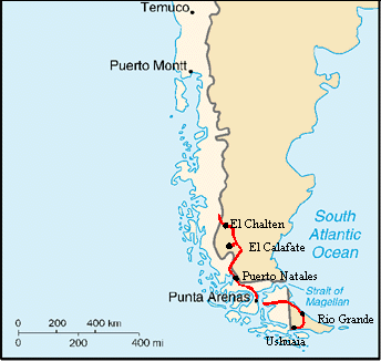
South America West Coast III (Chile and Argentine Patagonia) |
![]()
![]()
![]()
![]()
|
|
SOUTH AMERICA WEST ADVENTURE PART 3 CHILEAN AND ARGENTINE PATAGONIA Villa O'Higgins, Chile to Ushuaia, Argentina February 2 to March 17, 2002 Start 37,043 miles (59,747 km), end 37,831 miles (61,019 km) cumulative
Teasers:
|
| The stupidest thing we've ever done with a bike. | |
| Welcome to Patagonian winds. | |
| Ruta 23 beats Ruta 40 in the worst road contest. | |
| How do you get a mountain town in the middle of a desert, El Calafate. | |
| WOW! Torres del Paine. | |
| Punta Arenas, affluent, cosmopolitan, busy. What a change. | |
| Ruta 23 beats Ruta 40 in the worst road contest. | |
| Ushuaia, el fin del mundo. Penguins, sea lions, cormorants, snow, trees, cold. |
"The Westerly Wind asserting his sway from the south-west
quarter is often like a monarch gone mad, driving forth with wild
imprecations the most faithful of his courtiers to shipwreck, disaster,
and death."
Joseph Conrad (1857-1924), The Mirror of the Sea (1906)
One of the biggest difficulties about biking into Villa O'Higgins is subsequently figuring out how to get out. In 1999, when the road was first finished, this was essentially a dead end. Your options seemed to consist of: .1 biking back the 225 km to Cochrane, 2. pushing your bike for several days down the lake to an estancia in Argentina, 3. hiring horses to carry you and your bikes over this same trail, 4. convincing a man who runs a once a week lumber boat to carry you and your gear if he goes, or 5. build your own raft as some rather daring friends of ours did. Not one of these options was particularly easy.
Sensing the growing demand for easy passage to the Fitz Roy area of Argentina, the Chilean government has now subsidized a regular boat crossing. We'd been given a schedule in Coihaique which appeared to indicate a crossing more or less once a week on Saturday. In Cochrane we confirmed the Saturday schedule with the tourist office. Yet one German backpacker we'd met coming the other way seemed quite disgruntled about the boat. He complained that it had let him down by not showing up for 4 days. Yet everyone we met along the way kept insisting it sailed every Saturday. Even when we arrived, we immediately spoke with the captain's family to get our names on the list and they insisted that there would be a sailing on Saturday, weather permitting. The only explanation we can conceive for the German's bad experience was that he'd heard about an unusual Thursday crossing. So he rushed to the landing on the opposite side to wait. Meanwhile, in Chile the tourist offices and locals just keep telling people the sailing is on Saturday. So if there's just one backpacker waiting on the opposite side, why run? In any event, by the end of the Thursday before our Saturday crossing there were us 4 bikers and 3 backpackers signed up to go. So insufficient passengers could not be an excuse not to run. Weather or mechanical problems could be.
Now getting information about what's on the other side is even more difficult. Evidently passport control for both Chile and Argentina have been moved to the other side of the lake. Previously they were in Villa O'Higgins. Additionally, Chile has built a road going right up to their border. A road that was only one month old when we arrived. Beyond there lies only a horse trail and details about this trail vary widely. Some say it's so narrow that there's no way we could push the bikes with the bags attached. We'd have to make two trips, once for the bags and once for the bikes. Others point out that it is a horse trail, horses are rather wide, so there must be room. Some say the trail is easy. Others say it's hard. We've concluded that the only way to find out is to get over there and give it a try. There is always a fall back option of renting horses to get us to the nearest road.
Brian stood balanced at the top of a steep, rocky precipice. His entire weight and strength braced against the front handle bar of my bike. I leaned against the back, shoving with all my might against the sleeping bag roll. Brian growled, "This has got to be the stupidest thing we've ever done. This is a damn hiking trail. Not a biking trail. How'd we ever get ourselves into this mess. I can't believe we did this. Should have rented the horses. Never again. Never will I ever do anything like this again." I was too exhausted to do anything more than grunt. Two days after crossing over Lago O'Higgins we were somewhere between Lago del Desierto Norte and Lago del Desierto Sud struggling to get bikes and gear over one more horrendously steep and rocky hill. The trail that had started out so deceptively easy had turned into the worst possible nightmare we could ever have imagined.
The boat trip had gone remarkably well. We arrived at the captain's house right at 8:30 AM in time to catch a ride in his truck. The other cyclists had decided to ride. We knew that if the were any reason the captain suspected the weather would be bad, he'd cancel. We wanted to be absolutely sure he was going before getting to the boat. So we took the ride for the 7 tough looking km. Crossing the lake took the 4 hours as advertised and provided us with fabulous views. Although, the further into the main lake we got, the higher and higher the waves. We'd been lucky that the morning had started out so well as the afternoon was looking to be quite stormy.
So we arrived on the other side of the lake to find a very steep dirt road leading up from the boat ramp to the border check-out station. A man had greeted the boat asking if we wished to rent horses. I'm not sure if I'd call it naivete or just plain stupidity, but we decided that if the other 4 cyclists on the boat could push, then so could we. Besides, just how bad could it get. For the next five km we found ourselves pushing the bikes up a steep and loose rocky road. I was beginning to think, "If this continues like this, I don't think I can make it." Fortunately, or perhaps more appropriately unfortunately, the road leveled and actually became ridable. "Maybe this won't be so bad after all." we foolishly thought.
By the time we were about 10 km into the journey the rain, which had started as just an annoying drizzle, was really coming down. We'd been riding up and down the easy road for about an hour and now found ourselves at a dead end. Where to go now? The two French women cyclists who'd been just in front of us had already scoped out the situation and concluded that we all missed the turn we needed to take. The view of a house at the end of the road had drawn us all right to it. Everyone who'd been on the boat, 6 cyclists and 2 backpackers, completely missed the side road. Yet, this was a lucky break, probably the only one we'd have on the entire route. The house turned out to be an abandoned carabineros (police) station and it was open. Inside was warm and dry. So we all moved in. It made a great refugio for the night.
Early in the morning I rolled over, looked out the window, and sighed in great relief. The sun was shining, the wind was calm. It was a great day. After a quick breakfast we were once again on the trail. The side road we'd all so easily missed turned out to be that brand new, one month old 5 km section leading right to the Argentine/Chilean border. We found ourselves lulled into a false sense of security thinking that maybe the Argentine section wouldn't be so bad after all. The road was still soft, needing several years traffic and rain to compact the dirt. However, much was still ridable. All too soon we came upon the border. Abruptly the road and our fantasy came to an end.
Yet even the next 6 km gave no true indication of the misery yet to come. This was truly a trail, a hiking trail. In places the bushes left so small a space that the bike would literally wedge into place and we'd have to pull hard to free it. In other places it was so steep we'd have to either push up or carefully brake down. There were even a couple of knee deep streams to cross. The last 3 km were down a very, treacherous hill. Yet there were many spots where we could actually ride or glide, single track style. We polished off this 6 km in just 3 1/2 hours. Surely the section around Lago del Desierto couldn't be all that much worse.
It was at Lago del Desierto Norte that we made our fatal mistake. If we'd been smart, which we weren't, we would have asked the gendarmerie to radio ahead to the campground managers on the south side to bring on the horses. But, by this time we'd become convinced that the trail wasn't nearly all that bad. Even the gendarmerie proclaimed that, with the bikes, the trail should take a maximum of 5 1/2 hours. Confident that we'd either be done by the end this day or certainly very early the next, we pushed on. Within just 3 km we realized that we'd committed ourselves to the worst possible misery. Just imagine taking a U.S. National Park hiking trail rated as "difficult" and then not perform any maintenance for 10 years. Now try to take a 100 lbs fully loaded touring bike complete with front and rear panniers over it. Then you'll have some idea of what the trail was like. In places it was worn thigh deep and was only about a foot wide, far too narrow for bike and bags. I often had to get in front of the bike and pull hard on the handle bars to free it. The same also often happened with the thick vegetation on both sides. Overgrown vegetation often combined with the narrow trench to really make life hard. There were mud bogs in which the bike wheel sunk nearly to its hub. There were downed trees, easy for a horse or hiker to surmount, extremely difficult for both of us lifting bikes simultaneously to get over. There were boulders, rocky obstacles, and roots all making the path more and more difficult. Climbs were also very, very steep. In some cases we could push together, at other times we had to take everything off the bikes and quite literally relay everything from one spot to the next. Add to that the fact that we didn't think of taking off the pedals which continually banged against our right calves and shins or caught up in bushes, on rocks, or in those wretched trenches. Each and every km required the absolute maximum strength we each could muster. Early on the first day we could lift the loaded bikes over obstacles. By the end of the third we could barely push an unloaded bike up a hill. Ah yes, and we were also attacked by viciously hungry swarms of gnats all to add to the agony. All in all it took us about 20 hours to finish the last 14 km along Lago del Desierto. Next time there is an option to "push", HA!, along a trail or rent horses even at $35 U.S. per horse, we are absolutely, positively going to rent the horses.
A road never, every looked so good. Even a dirt road which we'd already been forewarned would turn into a rough, rocky experience before reaching Ruta 40 looked great. But, alas, we had to begin on the road with a bad discovery. Somewhere along that damnable trail Brian had smacked his bike right down on top of his rear derailleur. It was definitely bent. So we saved the blasted $70 needed for the horse, spent 2 days in misery, and still wound up doing enough damage to the bikes to probably equal half of that $70. Great!. Just imagine if one of us had gotten seriously hurt, a far too easy thing to have happen. Or suppose we'd lost our grip on the brakes and lost the entire bike and gear down a hill. Just imagine the cost of that damage. Yup, that was definitely the worst thing we've ever done with a bike. Not ever again. Although completely exhausted we forced ourselves up on the bikes and made our way into the very touristy town of El Chalten where we'd spend several days resting, recovering, repairing, and trying to put back on some of the weight we'd lost during our misadventure.
As we descended from Lago del Desierto to El Chalten the surrounding landscape became increasingly drier and drier. In fact, with the rugged, snow capped mountains at our backs and the brown grasslands to our front we were much reminded of the transition from the Grand Tetons to the eastern plains of Wyoming. We were right at home. Tucked within the brown cliffs surrounding the river valley was the quaint little town of El Chalten, our refuge for the next three days.
El Chalten is not a particularly old town, having been founded in the 1960s with the primary purpose of placing an Argentine claim to the region. Initially the town was simply populated with bureaucrats. Some 300 bureaucrats doing nothing other than providing services to each other. Now with the ever increasing outdoor enthusiasts flooding the town every summer, it has shifted its focus to providing services for the visitors. Generously spaced between the odd A frame shaped residential houses are many restaurants, hotels, and hostels. There are three descent supermercados, certainly much better than we saw in Villa O'Higgins and two very good and very busy bakeries. Virtually everything we needed was within a short walk from the campsite. Thank goodness as it took the first day of rest before either of us felt much like walking again.
It doesn't take too long to get to know a lot of folks living in El Chalten. Just stay put a few nights, visit the same store a few times, and you're practically a local. Most backpackers breeze in on one of the many buses, spend one night in a hostel, stock up on food, and then head off to hike the hills. Not many stay in town for several days. Before we left we got to know the woman at the bakery, the 3 women at the nearest store, and the fellows running the hostel del Lago quite well. If we had stayed much longer, who knows, we might have been invited to the christening of the grocery store lady's new baby.
The one absolute "must do" in El Chalten is the hike to Lago del Torre. Torre means tower in Spanish and it refers to the most unusual mount Fitzroy that does tower over the town. It is a huge, narrow conical light gray mountain topped off with a little mushroom shaped snow cap that is the bane to all climbers who attempt the over 3000 meter summit. This odd tower stands accompanied with a few similar peaks among fantastically glacier carved mountains. The 10 km trail leads to the edge of a muddy colored glacier lake into which a huge glacier still descends. From the top of the glacial moraine that traps the water of the lake one gets a perfect view of Mt. Fitzroy and its surroundings. Much of the time the mountains are shrouded in clouds. We got lucky. The day was warm, dry, and nearly perfectly clear. It was a scene that was well worth the effort.
We'd been expecting it. Knew we'd see it some time. But even still we were not quite prepared for it. "It" being the infamous Patagonian winds. Everything we'd heard and read always said that anything said about winds in Patagonia is not an exaggeration. It's complete truth. Our third night in El Chalten we had the great pleasure of experiencing this wind. The night started calm. We'd cooked dinner on the table outside, cleaned up, and gone to bed. Not too long after going to bed the winds began. They started fairly mild. Based upon the hostel manager's warning we'd already staked out the extra fly guy lines we'd brought and these seemed to be holding. But then the wind got worse. It howled with a fierce intensity that popped off the windward guy line. The tent pole bent dangerously downward. We couldn't afford to have a pole break. We both scrambled out of the tent to make a futile effort to reinforce the guy line. It didn't work. Each wind gust seemed only to intensify and again pop off the guy line. Everything we tried didn't work. Yet we had to find some way to hold that tend pole out.
We finally gave up. The only way we could keep that pole out seemed to be by pushing it from within. So we took turns. Each of us would lie facing the tent using feet or knees as a pole brace. Sleep was impossible. We had one long, long night. As a result of this experience we quickly learned how to properly orient and stake out the tent. It does result in a bit of a mine field of strings, each of us in turn tripped at least a dozen times over one guy line or another. But, at least from then on the tent stayed solidly in place.
So on into the interior of Argentina we go. A land of confusion and turmoil. I won't go into detail about it's history, having done so in one of our earlier South American newsletters. Just an update should suffice. After 4 years of continual recession, Argentina's economy finally hit the skids. As of December, 2001 the country was in debt up to a grand total of $143 billion U.S. Or, as we calculated, almost $4000 U.S. per man, woman, and child. Considering that the average income was somewhere around $6000, that's one very, very large debt. The IMF wasn't willing to lend any more money, not even on an emergency basis, until the country came up with a reasonable financial plan. So the politicians went to work, each coming up with a plan that the general public did not like. Riots broke out in the streets, grocery stores were looted, people invaded the congress building and burned furniture, just a general mayhem broke out in all the big cities. As a result the president, Menem, quit.
Soon began the most bizarre series of presidential terms we've ever seen. In the space of 2 weeks the country went through no less than 4 presidents. Each would be sworn in. They'd announce their plan to get the country out of it's mess, plans that always required some major sacrifice from the public sector, folks would riot in the streets, and the president would quit starting the cycle all over. One president lasted just one night. And we'll never forget the one who had the ludicrous idea of introducing yet a third currency into the economy, the Argentino. That idea failed miserably. News shots showing middle class people marching through the streets banging pots and pans became all too common place. The country seemed to be stuck in a complete stalemate needing to make major reforms yet producing major unrest every time someone tried to do something.
The fifth in this series of revolving door presidential terms, a man named Eduardo, seemed to finally get something done. Before anyone could bat an eye, he pushed through their congress a bill that unpegged the peso from the dollar. At first it was devalued to a rate of 1.4 to the dollar. Then it went to 1.7 and finally it was allowed to float on the free market where it seemed to settle out at around 2 to the dollar. The main effect of this devaluation was to make Argentina's products far more competitive on the international market. Of course the difficulty was that people who had saved in U.S. dollars now had savings in pesos, or essentially 1/2 its previous value. In addition, the national debt remained in U.S. dollars. There were problems. Banks were closed or were forced to limit the amount of cash withdrawals. People complained that they wanted their savings back in dollars, not pesos. Protests continued.
There's still much more that need to be done. Corruption in Argentina exists on a massive scale. Even the most lowly cop can easily be bribed into forgetting a traffic citation. Tax evasion is widespread. Estimates say that up to 70% of businessmen evade much of their taxes. The size of government is way to large. The province of San Juan is said to spend 85% of their annual budget on salaries alone. They have far too many people shuffling paperwork and not getting anything done. Will Argentina get its act together? We asked several people. The general consensus seems to be, no. They need an individual with the strength, integrity, and reputation to force all the needed changes. There just doesn't seem to be that person. Who knows what Argentina's future may hold at this point.
After another day scavenging about for supplies, getting ourselves cleaned up and rested, and getting the bikes ready once again for travel we headed out. We were headed east along the awful Ruta 23 which rumor claimed was even worse than the dreaded Ruta 40. All started well. The road surface seemed reasonable solid. Spots of loose, deep gravel were not too long and there always seemed to be a wheel rut of solid surface somewhere along width of this extremely wide road. We even had a good tail wind which added to our push. Yet soon after the Estancia Margarita things changed. The road surface turned to deep loose rock, gravel, and sand. Nowhere along its width could we find a hard path to ride. In some spots we were forced to dismount and walk. The further from the estancia we got the worse the road got.
Could we find a better route? According to our map there was supposed to be a more primitive road leading toward the lake. From what we'd seen of the more primitive roads, typically they are better for bikes than the "improved" roads. This is because they usually have just hardpacked dirt, none of that extra layer of gravel and rock. We'd even asked in El Chalten about the road and were assured it would have a hard surface. "Es bueno por bicicletas." It was supposedly 9 km shorter, hard surface, zero traffic. We gave it a try.
Well, the best of intentions turned awry. This little short cut turned out to be a double track 4X4 road with inches deep soft sand. Whereas on the road we had been able to ride, on this route it was virtually impossible. We were also riding without the aid of good directions. There was an abandoned hotel that was our goal. Easy to see, but not easy to get to. We finally wound up pushing our way across an old, fenced horse field through brambles that clung tenaciously to our socks and pants. The old hotel provided a nice stop for lunch and break from the incessant wind. But, we had to wonder why anyone would want to stay out there in the middle of nowhere. Perhaps that's why the hotel is now closed. Another 2 km and we were back to Ruta 40. Did we save distance? A few km perhaps. Did we save time or energy? No. That's not a short cut we'd be quick to recommend.
Ruta 40 certainly lives up to its notorious reputation. It's awful. We had to debate whether Ruta 23 was in fact worse as they both seemed virtually identical to us. Why is it so horrendous, you may ask? The basic problem is the road surface. It's not an issue of hills or steep climbs or even the quality of the road. In fact, for a car driver the road is probably not considered to be so bad. It's us bicyclists who have the rough time. The road surface consists of an extremely loose and deep coating of rocks ranging in size from billiard balls to marbles with a few loaves of bread scattered about. Additionally there is often an inches deep layer of sand or gravel. So either you find yourself bouncing wildly over these big rocks or sinking deep into the sand. Either way it takes an enormous effort to keep moving and keep upright. Occasionally there'll be a spot where the surface hardens for a bit. Here's where you can pick up some speed. But, no sooner do you get going than you hit another rough spot and all that momentum you just spent precious energy gaining gets dumped. You come to a grinding halt and have to grunt your way onward once again. It's exhausting.
Add to this the fact that Ruta 40 in this region runs right through the heart of the desert side of Patagonia. There's nothing but barren, dry grasslands all around. Over your shoulder are some stunning views of the jagged mountains with their snow and glacier caps. But if you're not lucky even these views can often be obscured by clouds. We've spent many, many months riding through landscape just as barren as this. Much of the western U.S. looks similar. In fact, if we were just plopped right down in this spot we'd have a hard time telling if we were in Patagonia or in Wyoming just east of the Grand Tetons, it's that similar. After spending so much time in these types of dry, plain like environments we find we really don't enjoy it that much. Yet much to our amazement we keep finding Europeans who want to see it. They specifically go out of their way to ride through it. We always feel compelled to ask, "Are you sure?" Although we did manage to get the truth out of one Frenchman who'd ridden all the way to Ushuaia and back, spending 3 weeks in the Pampas. He'd decided that was more than enough. I suspect, like us, even the European bikers get their fill of the Pampas after a while.
To top off all the road problems and the fact that this was not one of our favorite cycling environments, Brian was having serious derailleur problems. We'd tried to unbend it in El Chalten, taking advantage of a huge monkey wrench and vice. Yet it still seemed to be binding. Additionally, as we would learn later, his chain was coming apart. Many of the roller bearings were starting to crack and collapse causing the links to freeze. Frozen chain links cause the rear derailleur to skip making for nearly impossible riding. We were stunned to see this happen. In all our years touring over countless different types of terrain we'd never seen a chain do anything like this before. Recently Sachs was purchased by SRAM who was now producing the chains. We had to wonder if quality was now suffering. In any event, it made for 3 horrible days for Brian as we made our way over the horrendous Ruta 40 toward El Calafate.
It'd been a long day when we finally hit the short section of pavement that lead from Rio Gallegos to El Calafate. The road had been bad, the scenery so-so, the derailleur a royal pain. The infamous Patagonia winds blew at ferocious speeds from west to east right down the length of the paved road. To turn right would have meant 32 km of nearly impossible riding. There was no sheltered camping in sight. We'd heard that 10 km east was a small hotel that would allow you to camp among their trees at no cost. Yet to go east would mean an extra 10 km, probably into that howling headwind, the next day. What a choice. Go west and nearly kill ourselves riding into the wind. Go east and do the same thing for even longer. We decided to go east and take the chance. Perhaps we'd hitch a ride if the winds were too bad.
Amazingly we got lucky. There wasn't just no or a light wind the next day. We actually had a tail wind, a rip roaring tail wind that almost pushed us to within a mere 10 km of El Calafate. Sometimes, just sometimes, the wind gods to smile upon us.
El Calafate is a rather interesting town. It's located just to the east of the very large and aptly named Argentine Parque Nacional los Glacieres. It's situated on the shore of the huge Lago Argentino whose turquoise waters bear evidence of the many glaciers that feed into it. All around the town is nothing but the dry, brown grassy steppes we'd grown to know so very well over the previous days. There are no trees or green shrubs except for the few pockets where estancia owners have planted them, usually around their houses and barns. And of course the wind howls across the steppes throughout most of the summer season. The town center is located in a small dip in the terrain which provides a fair amount of shelter from the wind. Not once in our entire 4 night stay did we have to stake out our extra guy lines. In addition, it has a lot of trees, pine trees in fact. If you stood in the center of the town plaza and looked all around you get the distinct impression you're standing in the middle of some tourist mountain village. It's so easy to imagine that there are pine studded hills all around rather than the brown steppes. Reality seems displaced, at least until you reach the edge of town. The municipal camping is particularly mountain feeling with a clear creek and lots of shady trees. In fact, it was such a comfortable camping we found it was really hard to leave. Most bikers seem to stop in this camping for several days rest.
El Calafate's sole purpose is to be a tourist center for the most famous glacier in all Argentina, the Perito Moreno. Perito Moreno glacier is not the largest. The Upsala, which tumbles down from the same southern ice field a few km further north, is. Perito Moreno is so famous because it is more accessible, more spectacular, and completely unique. The front face of the glacier is a 5 km long, 50 meter high wedge shaped escarpment that drops directly into the main and Rico branches of Lago Argentino. The two arms of the lake are separated by a hill which today provides a perfect vantage point for viewing the glacier within just 300 meters of the icy face. What makes this particular glacier so unique is that, depending upon conditions, it can advance to the point where it blocks the narrow channel between the Rico branch and the main lake. When this happens the water of the Rico branch will rise behind this new ice dam. Eventually the pressure builds to the point where the dam bursts in an explosion of water and ice. This temporary dam used occur about once every 4 years. However, now the glacier has stabilized and remains in a fixed position, growing about 2 meters per year and calving about 2 meters per year. The last dam burst back in 1988.
Wooden cat walks take you to views of the north face, central area, south face, top, and bottom. People stand for hours totally entranced, watching and waiting. Every so often you hear a sound resembling the thunderclap of a gun shot. The ice has cracked. If you look fast enough you'll catch chunks of ice tumbling in almost a slow motion fashion into the turquoise water below. Oohs and aahs can be heard all along the catwalk and folks dash forward, too late, to try to snap a quick photo. Brian admired the blue. I was simply awed by the shear size of the ice. How many cities could this single glacier keep in water for a year?
Even though Puerto Natales is located south and a little west of El Calafate, you actually have to ride about 95 km east, south another 60, and then a back west to get there. Theoretically it is supposed to be possible to push/carry your bike over some pass directly to Torres del Paine national park. However, this is not a legal crossing and after having done such a push along Lago del Desierto, we weren't about to consider giving it a try. So we headed west for 95 km of paved road back into the flat, brown grasslands of the pampas which looked so much like eastern Wyoming. For this stretch of road even the majestic views of the mountains weren't all that readily visible. This was certainly not our favorite type of riding environment. Leave it to the Europeans.
Ninety-five kilometers of pavement. Aah, that does sound soooo good. Dirt roads can be fun, exciting, challenging, a real adventure. But, after so many kilometers of literally pounding your brains, or more likely butt, a day of smooth riding sure can feel good. True to our luck, the west to east howling wind we had hoped to experience did not happen. In fact, there was hardly any wind at all, meaning we had to climb up that 2000 ft hill out of the Santa Cruz river valley all on our own power. Oh well, the wind gods made up for their mistake by not giving us that same howling winds when we turned back west toward Chile. It does even out in the end.
Camping was proving to be tricky. This brown, grassy stuff is actually quite stiff and sharp. Everything in the desert sticks, stings, or stinks as the saying goes. We'd found a nice spot to camp next to a creek right on top of this grass thinking it's be at least pliable. It was only after we had the tent up that we realized that this grass was sticking through the bottom of the tent and right into our fingers. Put a Thermarest mattress on that and you'd be patching holes for an eternity. So we took everything down, packed it up, and moved to the other side of the creek where at least the grass was green.
The next night we arrived at the intersection, called Tapi Aike, where we'd turn west again. Winds were roaring and after the previous day's long distance we had no desire to push onward. Here we found a small police station, a road department shop, and a tiny gas station. The fellow at the road department house gave us permission to camp in the shed behind the house, out of the wind. He also offered the use of his bathroom for a hot shower, an offer too good to refuse. However, that night to power his house he turned on a huge generator right behind the house and kept it on until about 1 AM. When this finally shut off, the cats showed up. A mama cat nibbled on the meat drying in the shed while her kittens mewed loudly. Quiet, eh? I don't think so. Ah yes, the adventures of camping in the desert. When the choice came to turn into Chile toward wetter climates or to continue south in Argentina through the pampas you can guess which way we went.
The fellow at the road crew station sure was nice. Either that or he just welcomed the opportunity to talk to someone else besides the gas station attendant and police person. He lives at the house alone for 15 to 20 days while his wife and son stay in Rio Gallegos. Normally he drives one of the grading machines and the snow plow in winter. With Argentina's financial problems much of the road work has come to a grinding halt. "No hay plata." he'd say while rubbing his finger and thumb together. They'd been in the process of rebuilding and paving the road from La Esperanza to 28 de Noviembre when everything came to a halt. The equipment now sits idle and this fellow sits at this house day after day just keeping an eye on things. The way things are looking now, I can't imagine the situation will change in the near future either.
Once past the Argentine border post at Cancha Carrera and the Chilean post at Cerro Castillo, we had a decision to make. Either we turn north to ride through the world famous Parque Nacional Torres del Paine or we turn south toward Puerto Natales. We had been lucky enough to meet a Frenchman who'd ridden through the park. His suggestion was rather than riding through the park, an expedition that would take 8 days and not get to the the best parts of the park, we should go to Puerto Natales, rent backpacks, and take the bus back up to hike the park instead. We'd had friends who rode into the park a couple of years earlier and their one comment was that they wished they could have done some trekking. So the decision was fairly easy, we turned south to Puerto Natales to look into renting backpacks.
Puerto Natales is a town of about 20,000 permanent inhabitants situated on the southern inside passage. It's the most southern terminus for the Navimag ferry from Puerto Montt and the main jumping-off point for excursions of all sorts into Parques Torres del Paine and Bernardo O'Higgins. Consequently it's mostly a tourist service town having over 70 lodging choices, lots of restaurants, many tour and bus companies, and tourist trinket shops. It also has sufficient grocery stores to readily outfit yourself for a good long hike in the park. It really is a comfortable place in which to settle for a few days.
Our first order of business was to figure out what type of hike we were wanting to do. There's the very famous Torres del Paine circuit, a 5 to 8 day long circular backpacking tour that takes you through the best and some of the remotest regions of the park. This would take longer than we wanted. A second, more suitable, option was suggested by a woman we met at an internet cafe. There's a hike called the W. The trail is essentially an oddly shaped W with the legs leading up to view points of the famous torres and glaciers. You camp at locations on the base of the W and from there take day hikes up the legs. It takes about 5 to 6 days, depending on the weather, and you don't need to carry all your gear and food nearly as far as for the circuit. This was a hike perfectly suited for us. We rented the backpacks, bought a bunch of food, stored the bikes at the camping, and were off for a walking adventure for a change.
Parque Nacional Torres del Paine (pronounced like pie-nay) is located about 130 km almost directly north of Puerto Natales in the most southerly regions of Chile. It is perhaps the most famous of Chile's parks both nationally and internationally. Deservedly so. Within its borders one finds some of the most spectacular scenery in all South America.
The park derives its name from a series of very distinctive, granite monoliths that reach up to 1000 meters into the air. The Chileans call them towers (torres). They're not entirely sure where the Paine name originated. If you look closely it is obvious that the towers were originally part of a much larger granite mountain capped off by a softer, dark cap rock. Through tens of thousands of years, glaciers perched on top of this mountain have chewed a huge cavity right through its center, somehow leaving behind these tall, conical shaped towers in the process. It's quite something to see these huge, pinkish towers stretching to touch the clouds, all lined up in a row almost like teeth. Any trip to the park has to include multiple views of these spectacular peaks.
Another not-to-be-missed sight is Glacier Lady Grey. Located up the third leg of the famous W, it is a huge, 3 branched glacier that drops into the huge glacier, silt filled lake of the same name. Pale blue icebergs the size of castles float throughout the lake having calved from one of the three glacier toes. If you are lucky you'll get to see the glacier in sunny weather. If not, it can be terribly cold and gray.
Hiking the famous W will take you to spectacular viewpoints of both the towers and glacier Grey as well as a grand vista of Valle Frances, a valley surrounded by a semicircular crown of glaciers high in the mountain peaks. It can be done in a number of different ways and usually takes about 5 days. You can pack your gear to camp sites located along the base of the W and take day hikes up each leg to the viewpoints. Or you could actually lug your gear up each leg to stay at the free camp sites located closer to the vistas. Either way involves some very, very tough hiking. There are some extremely steep climbs to make, a lot of rock scrambling, rivers to cross, and muddy swamps to slug through. Distances are long, usually anywhere from 5 to 8 hours hiking each day. Without a doubt you find yourself plenty exhausted after each day.
Fortunately, unlike U.S. national parks there is no need to make any sort of reservation or get a camping permit if you are camping. If you want to stay in a refugio, reservations are a must. The nice part about the no-permit policy is that you don't have to decide in advance just how long you want to take to finish the hike. If you so choose, or if the weather really gets foul, you can simply hold up in one spot for an extra day, week, or month if you so choose. You can even buy meals, bread, and a few snack items at the refugios, for a price that's quite high. On the other hand, it does make for camp site locations that can be quite crowded and, as was for the case of Campo Italiano, often with overloaded toilet facilities. It's not like being in a U.S. park where you may be the only ones camped at a backcountry site. So it has both advantages and disadvantages.
Chilean trails are an adventure in and of themselves. We are convinced that "switchbacks" not only are not part of the Chilean language, they're not even part of their culture. Trails go straight up and straight back down most hills. Ropes intended to help you pull yourself up a steep, muddy or rocky cliffs are not uncommon. How about wooden handrails nailed onto trees that we think are more intended to keep you from accidentally launching yourself into midair than for helping your stability. And the rock scrambles are real fun. These are places where the trail heads out across or up a region of former rock slides. The general direction of the trail is simply marked by orange dots painted on the VW sized boulders. You get to choose the route that safely gets you from one dot to the next, hopefully. One thing for certain, at the end of 5 days scrambling, climbing, sliding we were plenty hiked out.
To the east of Puerto Natales along the paved road heading to Punta Arenas is a land of low, rolling hills, expanses of brown grasslands, and almost no protection from the winds. It tends to be cold, windy, and dry, all the qualities you find in eastern Wyoming in the very late fall. Riding with the wind is a wild treat, riding into the wind is hard labor, camping can be almost impossible. Except for one little gift from the communities. Along the route at almost every estancia stands a cute little off yellow building with a light blue roof. They look like cupolas stolen from the top of local churches and placed at the roadside instead. These are bus stops. They have doors that actually close, glass windows, a little bench, even trash disposal. It happens that they also are the perfect size for 2 people to sleep side-by-side, as long as neither person is more than 6 ft tall. We spent one night in the little bus stop located at the side road to Estancia Laguna Blanca. We were by no means the first. On the wall is a growing list of other bike tourists who'd stopped for a rest or perhaps to spend the night. There were 2 Japanese, a couple from Poland, an Argentine, and that Swiss, Alaska to Tierra del Fuego rider we'd met back in the lake country. He'd passed through only 10 days before us. Now there is an addition, the couple from USA riding from Santiago to Tierra del Fuego.
It had to happen eventually. There was no way we could escape it. I doubt any biker ever completely avoids it. WINDS! Up until we made our way into Punta Arenas we'd managed to miss experiencing winds too strong for riding. But, our luck finally ran out. We'd ridden out of Puerto Natales on a fairly calm Saturday morning. Winds picked up throughout the day eventually reaching steady strong velocities. Yet, we were headed either east or southeast while the winds came from the north northwest. Tailwind. It was easy to knock of a quick 134 km for the day over low rolling hills and pavement. Our second day winds of about the same velocity came from the west southwest. It was a bit of a struggle against the headwind, but certainly we could ride.
With just 22 km to go to reach Punta Arenas we figured that certainly we'd have no trouble getting into the city well before noon. That was until we left the shelter of the tree covered, free campsite just north of town. Immediately we were blasted by icy cold winds literally directly over our right shoulder. I got on my bike and suddenly found I was in the middle of the road. Another blast of wind and I was on the left shoulder headed toward the ditch. There seemed to be no way I could get that bike back on the right side of the road. I simply wound up standing still, using all my might just to keep bike upright against the wind. Meanwhile trucks and cars passing by on the highway also veered sideways as they fought the dreadful winds. We just couldn't ride.
There are times when bike touring can be extremely difficult. There are times when the road simply sucks, when the weather makes you feel miserable, the drivers and traffic drive you crazy. But these are all matters of comfort. You may feel really, really awful. But you can still ride. However, there does occasionally come a time when you have to admit that biking a certain day or section of road just isn't worth it. It's just not worth risking a major accident just to ride absolutely every single kilometer. This was one of those occasions. We didn't have enough water or even the desire to wait out of town an extra day and the wind made the riding far too dangerous. Out came our thumbs. Within an hour one of those old, beat up pick-up trucks came to a halt, the man in the passenger seat climbed out and without so much as a blink of an eye he loaded us and our bikes into the back and we were off. We used caution this day and lived to ride another.
Punta Arenas (sandy point) is Chile's most southern city. With a population of over 130,000 it seems like quite a cosmopolitan environment especially in light of all the podunk little villages we'd seen for over a month. In 1841 el presidente Bulnes decided to establish a Chilean town in these southern regions to head off expansionist ideas by both Argentina and France. In 1843 he sent Charles Willliams, on loan from the English navy, and a bunch of hardy souls down to the area of Punta Arenas with the orders to establish a fort and settlement. The fort, Fuerte Bulnes, was located some 7 km south of the present city center. The current city was founded in 1848 after it was concluded that this was a far more sheltered area to place a town.
Over the years, the town became a major port supporting the very wealthy sheep farmers throughout the area. Many built luxurious mansions in the opulent 1800s style within the city while maintaining estancias in much further flung locations of the region. The town is filled with reminders of these former sheep barons, Menedez and Braun to name a couple. Streets, mansions, and mausoleums in the cemetery all bear names of these locally famous personalities. Some of these stone mansions remain in the hands of private individuals while others have been turned over to the state and city for use for civic functions or as museums. Fortunately many of the old structures remain. Even newer structures seem to be built to blend well with the surrounding architecture thus giving the downtown area a very upscale European feel. It's a nice city. Too bad its weather has to be so fickle.
The one item we really wanted to see was the naval and maritime museum. It's housed in one of the old 1800s style mansions, now painted white with blue trim, and has 2 full floors filled with interesting photos, artifacts, models, and other odds and ends from Punta Arenas' naval history. Most unique are some of the photos taken of successful as well as failed expeditions to Antarctica and around cape horn. But the most interesting thing to see was the video. The museum has a copy of a video, produced by the Mystic Seaport Maritime Museum in Massachusetts, that shows old 1929 films made by a sailor aboard one of the very last 4 mast, square rigged boats to sail around Cape Horn on a cargo run. The video, made in 1980, was narrated by a Captain Johnson who was the young man who made the original film back in 1929. It was absolutely incredible to watch these sailors braving the ravaging storms of Cape Horn all to keep that ship afloat. His comment about safety regulations was priceless. There were none. You looked after yourself because if you didn't you wound up dead. There was no room for error. The video alone was worth the price of admission.
"What do you mean it leaves at 5 PM?" Here we were at the wee hour of 8 AM, standing at the ferry dock wondering what to do next. Firmly grasped in our hands was a schedule, easily obtained at the tourist information office, that claimed the ferry left at 9 AM. An amended schedule posted on the door to the ticket office countermanded this by 8 hours. Here we'd set the alarm, gobbled down a quick breakfast, braced ourselves for the icy winds, and pedaled the 5 km to the ferry terminal. All in vain. We'd be forced to sit around and wait 8 more hours. Our one consolation was that we were not alone. Several other potential passengers arrived just to learn the same thing during the 15 minutes we stood pondering our next move.
So what to do for 8 hours? Fortunately there happened to be a rather interesting museum just down the street. Spread out across a field in front of the Puerto Arenas university is a fairly large selection of old, pioneer style farm machinery, a virtual treasure trove for mechanically curious people. There were steam engines, carts, wagons, seeders, hay cutters, hail bailers, road graders, antique carriages, and antique autos. There was an example sheep shearing shed, a replica auto shop, a barn full of odds and ends of sheep related stuff, and a replica pioneer cabin. The most unusual thing was this odd contraption they used to restrain oxen while putting shoes and other equipment on. It took a few reviews of the dictionary to figure out what this thing was.
Interesting as it was, the museum only took at most 2 hours. So then what? Across the street is an area known as the "zona franca" (free zone). It's an area where duty free stores are permitted. It's full of stores selling everything from food to electronics, toys, furniture, and cars. Most importantly for our situation, it was an indoor, heated mall. At least we'd have a place to sit out the remain hours. We did also marvel at some of the imported food items. Pork and beans, decaffeinated tea, and other items we hadn't seen for months sat oh so temptingly close on those shelves. But, our food supply was full and we had no desire to carry any more weight. They'd have to stay where they sat.
Just after 7:30 PM the ferry unceremoniously dumped us off 5 km west of the little port town of Porvenir. We promptly hopped on the bikes, endured a frigid but thankfully flat ride into town, found lodging, food, and settled in for our first night in the most southerly region of Tierra del Fuego. It is believed that Tierra del Fuego (land of fire) was so named by Magellan because of all the fires lit by the natives living in the area. The area from the Straits of Magellan to Cape Horn was originally inhabited by a people calling themselves the Yamana, meaning us. They seemed to be divided into 2 general groups, those that hunted sea lions and those that hunted the guanaco, a camel relative. The Yamana were a short, stocky people with broad chests and skinny legs. They hardly wore any clothes, using fires to keep warm. Hence the fires throughout the land spotted by Magellan. Unfortunately the entire Yamana peoples were exterminated from all the diseases brought by Europeans. No Tierra del Fuego natives exist today.
For a land bearing a name that evokes the image of heat and warmth, Tierra del Fuego can hardly be further from that image. The north part of the island is a cold, windswept grassland with only low, rolling hills providing any change from the sweeping scenery. South of Lago Fagnano, about half way down, it becomes much more mountainous and forested. The primary tree is the lenga, a deciduous tree that seems to fit the ecosystem as the pine does in the north. The mountains are not particularly high, a couple thousand feet at most. Yet at these extreme southern latitudes even these very low peaks sport glaciers and year round snow fields. Of course as in most of Patagonia, the winds are absolutely merciless. They can howl, night and day, making an already chilly environment seem downright frigid. When the winds are calm, the weather can be tolerable. Add winds and it is miserable.
Much to our amazement our first day on this island at the end of the world was sunny and dead calm. We had a great riding day. The wonderfully good Chilean dirt road took us across a peninsula and then along the length of the Bahia Inutil. The bay received its name in 1829 when a hydrographic team from Chile determined that this very large bay on the northern side of Isla Grand de Tierra del Fuego was virtually useless as a shipping port, useless bay. The waters were incredibly calm, fantastic blue, and perfectly clear. Such a contrast to the surrounding brown grassy hills. It was a great day for seeing animals; guanacos, rheas, fox, dolphins. After 100 km riding, we pitched our tent on the lea side of a small hill, hoping against all hope that the winds would remain calm for one more day.
Naturally they didn't. By the time we'd finished dinner and were tucking ourselves into the sleeping bags, the winds were beginning to come back to life. They continued to crescendo throughout the night, reaching gale force by morning. It's always so exciting trying to get the tent put away under horrific wind conditions. Fortunately we had the winds at our backs, a lucky change.. The next 135 km flew by. We managed to roll on into Rio Grande with plenty of daylight left to find the camping and head to the store for dinner. Now we'd need to wait to see what happened next. The final leg of our journey to Ushuaia involved riding south and then west. Wind could make or break us along this stretch.
Rio Grande is not a particularly attractive town. It's clean, modern, looks fairly well off. Yet it seems too sprawling. They also seem to have tried a bit too hard to add interest to the streets. For long distances along the main avenues there are funny looking lamps, statues, art works, and other stuff that just seems a bit out of place. You do have to admire their attempt to add interest to an obviously flat, monotonous landscape. Still, this is primarily an oil and ranch support town. Tourism is only a secondary concern, if even a concern at all. They do have a nice camping/boat club which provides a great common room from which we could sit quietly and weigh the options for continuing on.
Just a little more dirt, a lot more pavement and we'd finally arrive, Ushuaia. It was cold. It was windy. Yet at least it didn't rain. As we've found so often in this Patagonian region, we were not entirely prepared for the amazingly rapid change in terrain. Leaving Rio Grande, you ride through about 50 more km of that same, rolling brown grassland. There are no trees, no shelter from the winds, views that go on for ever across the hill tops. At about the 50 km mark you start passing short lenga trees. It looks a little like the start of the short juniper forests in the foothills of the Rocky mountains. The trees grow taller and the ground vegetation greener the further along you go. By the time you reach Garabaldi pass and head down the other side, about 70 km later, you find yourself in lush forests. There s absolutely no indication whatsoever that the dry grasslands of the east and north parts of the island exist. We could only imagine how the bikers who start in Ushuaia must feel. They start out in this lush, green environment. Within a day they're over the top of the pass and into the dry grasslands having to deal with that infamous winds. Little do they realize that they'll have to put up with that pampas environment for weeks on end. For those of us who are familiar with the desert and plains of the U.S. it's something we are ready to deal with. But, for Europeans who've never seen anything like it before, I can only imagine their reaction.
Ushuaia at last. Ushuaia is a city of approximately 60,000 people and has existed for only about 100 years. It is located on a well protected cove on the Beagle Channel surrounded by snow capped peaks of the most southern Andes mountains. Its name, Ushuaia, means "bay that faces west" in the local native language. There is a continual debate between Argentines and Chileans about whether Ushuaia or Puerto Williams is the most southerly town. Puerto Williams is located on Isla Navarino across the channel and a little further east. In reality, Puerto William is the most southerly permanently inhabited settlement whereas Ushuaia can legitimately be considered to be the world's most southerly city. Yet Argentines say that Puerto Williams is no more than a military base, so it doesn't count. Yet it does have a few hospedajes and restaurants so it really is a true town.
Interestingly, from the time the Magellan expedition completed its circumnavigation of the globe in 1520, it took another 300 years before it was determined that the Beagle channel really was a passage between the Atlantic and Pacific. If you enter the channel from the east, an entrance only about 1 km wide, you'll see what appears to be the end of a long bay. The channel curves around so much you can't see an exit. It took the journey by Captain Fitzroy in the 1830s to find this exit. This was the expedition of the Beagle, the boat for which the channel is named, on which Charles Darwin made his historic round the world journey. So it was clearly an expedition that resulted in a lot of interesting discoveries.
Ushuaia is a fairly busy port city. Being a mere 700 miles from the western hemisphere Antarctica research stations, it has become the main supply and support port for these stations. Daily there will be Russian, Chinese, American, and other ships in port loading and unloading crates. You can, if you want, pay for passage aboard one of these boats for a grand tour of the Antarctica. Cost is around $2500 U.S. and it can take from 10 days to 2 weeks. It'd be something to say you've been there. But, it's so expensive. I suppose we'll wait until there's no other continent on the planet left to explore, which may take a long time.
Tourism is also becoming a major business for Ushuaia. We tourists flock to the city just to say we've been there. There are some neat things to see. The best and the main thing we want to do was take the boat tour out to the penguin rookery. Within the past 15 years a small colony of penguins have begun to come to one of the islands in the Beagle channel for laying eggs and hatching young. They arrive in December and by April most of the young are molting their chick feathers in preparation to take to the water. We've seen sea lions along the California coast. We've traveled on boats in a variety of places. We've hiked trails, seen glaciers, viewed lighthouses, visited museums. We haven't seen a penguin rookery. This was our number one priority.
The day after we arrived was absolutely the most perfect day for taking the boat tour to the rookery. Ushuaia is usually cloud covered, often rainy, snowy, and windy. This day happened to have perfectly clear, blue skies and was dead calm. We asked the tour guide how often the weather was like this. She responded, this was only the third or fourth for the entire season. It was a wonderfully perfect day.
After getting a few chores done, such as laundry and buying airline tickets to Mendoza, we checked out boat tours. There were several choices ranging from a 3 to 4 hour tour on a small boat to a 6 hour ride on a luxury catamaran. Of all the available tours, only the catamaran visited the penguins. It was the most expensive. But since the rookery was the one item we really wanted to see, this was the tour to take.
Our boat left at 3 PM, made short visits at the sea lion, fur seal, and cormorant colonies, swung by Argentina's most southern lighthouse, and then proceeded out for 1 1/2 hours along the channel for the penguin rookery. Being a catamaran, the boat had the ability to nudge its pontoons right up onto the rocky island shore. As we pulled up, these cute little penguins all gathered around to take a look. They seemed just as curious of us as we were of them. They're really adorable. They waddle around all the while looking at this strange giant boat that has pulled up on their shore. It would have been nice to stay all day or to be able to get off the boat to wander among these little creatures. But, I suppose too much of that kind of tourist attention would probably cause serious problems for the rookery. We'd have to be satisfied with just our off-shore visit. With an hour long bus ride back to town, we returned feeling entirely satisfied that we'd seen what we came to see. Anything else would just be gravy.
We spent our last 2 days in these southern extremes not doing a whole lot. The weather had turned foul and cold and we simply didn't have a whole lot of ambition for hiking, biking, or doing much else. So we just wandered around town, visited the fin del mundo museum, admired the sail boats out on the harbor, and generally did nothing. After so much rough riding since Puerto Montt, this rest was well worth while. Now, time to head north.
Trail from Lago O'Higgins to Lago del Desierto
Ruta 23, El Chalten to Ruta 40
Ruta 40 to El Calafate
Ruta 40 to Cancha Carerra
Cancah Carerra to Cerro Castilloto Puerto Natales
Puerto Natales to Punta Arenas
Porvenir to Rio Grande to Ushuaia
Lost due to user screw-up
|
Copyright © 1995-2011 by Caryl L. Bergeron - Distribution for personal use permitted. Distribution for other uses with written permission.
Acknowledgements
|