Putre, Chile to Bolivian
Border
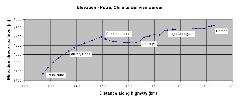
The junction to the town of Putre is located at Km 127 along Ruta 11.
Putre is located 4.86 km off route. The side road is paved and in good
condition. However, there are a lot of ups and downs getting to Putre. The
junction is 90 meters above the town. Putre is a good place to aclimitize to the
altitude.
Upon leaving Putre the road climbs very steeply for about 8 km before
leveling on the altiplano. Experts say that to avoid getting altitude sickness
you should first aclimitize to the 3000 meter (10,000 ft) level. From there on
up you should climb no more than about 350 meters (1,000 ft) each day. It's
difficult to do out of Putre. I have marked campsite locations and elevations to
help in this.
Kilometers in Chile are measured from the intersection of Ruta 5 and Ruta 11.
Putre is at km 127. Green signs alongside the road give the km location and are
used here. Altitude is from an altimeter we carried. It matched the official
number at both Putre and Las Cueves. However, it seemed to be different for
Chungara and the Chilean border. We do not know whether the difference is due to
the fact that we did not recalibrate the altimeter following a front passage or
if the Chilean data is incorrect. This does give a general feel for the level of
climb and descent.
Putre - hotels, restaurants, good stores, phone
km
127- Jct to Putre
km 134.5 - creek crosses road, good water, good campsite
left side off road
km 137 - Starting about here all the way to Las Cueves
you follow close to a stream with good water
km 141 - slope lessens a bit
km 146+ - Las Cueves, get water
km 152 - large mirador, good campsite
km 160 -Carabineros station, get water
km 163 - Chucuyo, 2 restaurants,
also have rooms to let. Copihue de Oro sells bread, cookies, sodas, and some
basics such as rice and some canned goods
km 166 - Turn-off for Parinacota
near here, 4 km off route, downhill. Accomodations and meals available at
people's houses.
km 180 - Refugio lago Chungara; camping, lodging, no food,
water
km 185.5/0 - Chilean border control, snack stand
Bolivian Border to
Patacamaya, Rt 1
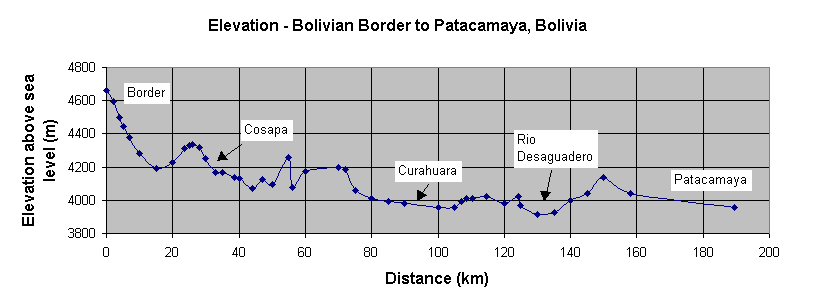
Bolivian route 108 from the border to Patacamaya is a
wonderfully paved road in great condition and with a wide shoulder. Distances
are measured from whichever end you start at, 0 at the Chilean border or 0 at
Patacamaya. I give distances here from the Chilean border.
There are many small streams that pass under the road all the way from the
border to km 44. Some look questionable as to cleanliness. Ones closer to towns
have a lot of trash. Others could probably be filtered with no problem. They
appear to run directly from the snow covered volcano without passing through a
town. People in these remote villages use latrines that are placed well away
from water sources. Consequently chances of raw sewage getting into these
streams is slim. Do not make the same assumption for any stream that has passed
through a town having a "sewage system" of any type. There are tons of llamas
all over the hills and the women do wash clothes in the streams. So filtering
and possibly even iodine treatment is recommended. Below I make note of some of
the larger streams we passed. There are many much smaller ones that are not
noted.
km 4 - Following creek that looks reasonably clean
km 7.7 - Tambo
Quemado; Restaruants, lodging, small stores
km 17 - Rio Sajama, clean
km
19 - Lagunas; restaurant seems closed for good.
km 22 - Stream, clean
km
24.3 - Creek, clean
km 26 - Peak of climb
km 27.5 - Creek, clean
km
36.8 - Jct Cosapa (9 km downhill)
km 44 - Rio Tomaripe, clean
km
48.6-bar/pension El Viajero
km 55 - creek, good camp site
km 69.3, 69.8
- Bars,closed?
km 77 - Start along river
km 79.4 - Pension
km 81 -
Turn-off to small town, no services
km 91.6 - Restaurant Juventud also small
store
km 92.6 - Turn to Curahuara de Carangas (5 km), 4 restaurants with
supplies at intersection, town has lodging, stores, phone, restaurants, medical
center
km 105.5 - Cross river Sulloma, muddy, leave valley
km 130 -
Bridge over Rio Desaquedero, muddy water in river
km 150 - Snack store
km 189.5 - Patacamaya; hotel,restaurants, stores, gas, phone
Patacamaya to La Paz, Bolivia
The
road from Patacamaya to La Paz is an older road. The main thoroughfare is in
good condition, but the shoulder is often in bad shape. Traffic is quite busy
especially with buses. You will climb gradually up to El Alto, the city above La
Paz. Usually wind comes from north to south so you may have a headwind as
well. El Alto is a very, very busy city. You will have to just push
through the throng until reaching the autopista. There is a toll booth at the
start of the autopista as well as a sign saying bike are prohibited. We just
ignored this sign and went on through. Nobody stopped us. Once on the autopista
you'll find a nice, divided 4 lane highway with wide shoulder and a wonderful
ride down to La Paz center. This is definitely the way to get into the center.
Once you pass the brewery you may want to get off the bike and start walking as
pedestrian and bus traffic gets really tough further on. Riding up this hill
could be a real killer especialy considering the altitude.
km 125 - Patacamaya; Hotels, restaurants, gas, phone
km 132.5 - Turn to
hot springs resort hotel and restaurant
km 145.5 - Ayo Ayo; stores to get
drinks, most not open on Sunday
km 147 - Tholar; hotel, restaurant, snack
stores
km 170 - Calamarca; small snack shops
km 178- Pocohata; small
snack shops
km 184 - San Antonio; phone
km 187 - V Remedos; noservices
km 200 - Start El Alto - All services
km 240 - La Paz; All services
La Paz, Bolivia to
Desaguadero, Bolivia
From El Alto the road to Desaquadero is generally
fairly level. There is one fairly good climb just after the town of Tambillo.
Actually this hill feels harder than it really is just because you are at such a
high elevation. This road is paved all the way and is in very good condition.
Shoulders are generally dirt but still good for riding. Traffic is light so you
can ride on the thoroughfare if you choose. Small stores probably can be found
at all the towns along the way although, with the exceptions below, we did not
check them out. Don't expect to find too many hotels along the way.
Tiwanaku has restaurants, small stores, and one pretty good hotel and one
real dump hotel.
Desaguadero on the Bolivia side is a real ugly, dirty city. You have to turn
right off the main, paved road toward the center of town to reach the border.
The paved road heads elsewhere, not to Peru. It seemed to us that the Peruvian
side of town was a bit nicer than the Bolivian side. There are hotels on both
sides of the border, however we still wonder if those on the Peruvian side might
be nicer. There are many small shops, snack stands, and some restaurants on both
sides. However, restaurants may not be open on Sunday.
Km 0 - Rio Seco junction route to Tiwanaku, 4000 m
Km 19 - Jct to Laja:
nice church, may have small stores
Km 34.5 - Jct to Tambillo, 3850 m
Km
37 - 3965 m
Km 37.8 - 4020 m
Km 42 - 3907 m
Km 55 - Jct to Tiwanaku:
restaurants, hotels, stores
Km 74 - Guaqui - Stores?, gas, phone
Km 102
- Desaguadero