| Caryl and Brian's World Bike Tour |
|
South America Bus trip - 3 |
![]()
![]()
![]()
|
|
SOUTH AMERICA BUS TRIP 3
Puerto Madryn, Argentina to Lima, Peru February 21, 2005 to March 22, 2005
Teasers: Wander the mountainous territory around Argentina's Lake District. Another marathon bus ride half way across the S. American continent. Discover the difficulties of being a Carmelita nun back in the 1600s. Clamber through underground tunnels of a coop mine in Potosi. Party hardy at the Estrella Andina Hostal in La Paz. Visit a much different Carmelita convent in Arequipa. See condors in flight in the world's second deepest canyon. Fly high over the mysterious Nasca lines.
"If it is better to travel than to arrive, it is because traveling is a constant arriving, while arrival that precludes further traveling is most easily attained by going to sleep or dying." John Dewey (1859-1952). Human Nature and Conduct: An Introduction to Social Psychology, 4.1, 1922
El Bolson, a town situated about 1 hour south of Bariloche, has more of a small town, slow going feel. Hotels are few and small. The main street, essentially only one, extends just three or four long well spaced blocks. Due to lack of competition restaurants are few and rather expensive when compared to Bariloche. Campgrounds are much more readily available, albeit quite crowded this time of year. Parking is free, certainly not the case in Bariloche. And the main plaza looks almost exactly like a town park you'd see in the U.S. It's a big lagoon surrounded by shade trees and manicured lawns with picnic tables scattered about.
Backpackers sporting long dred rag and wearing the usual backpacker's costume of loose fitting, oddly colored clothing abound. Just try to tell them they look like they're wearing a uniform and they'd be thoroughly insulted. Many of them tote folding boards bearing all manner of cheap jewelry to sell in the park. Or they have a variety of balls, bowling pins, flags, or unicycles so they can display their "skills" at the few stoplights in town. These are the ones who have very questionable sources of income. But this time of year these folks are counterbalanced by your average shorts sporting, camera laden tourist with a carload of camping gear and miscellaneous toys. Gosh, it looks a lot like one of the smaller U.S. tourist resorts in the dead of summer vacation.
El Bolson is situated in a pretty green valley with rugged mountains running north/south on both sides. The mountains to the west provide a bit of a rain shadow resulting in slightly drier peaks to the east. Rough dirt roads lead in various directions up these hills to certain viewpoints and a few small waterfalls. We visited one set of waterfalls, just one. Each one of the stops along the tourist drive charges 3 pesos entry so we kept our selection to the one that had the botanical garden, which in itself was well worth a stroll. The other stops, eh no interest. Then we headed on up the mountain to a tiny, defunct ski area with a supposedly year round refugio. Here we wandered around for about an hour gaining grand vistas of the surrounding hillsides. Other hiking would have been nice, but by the time we returned to El Bolson it was getting dark and we needed to set up camp and eat dinner. So much for El Bolson.
Upon returning to Bariloche we decided to tour the gamut of tourist circuits recommended in their various brochures. This is where the flexibility of our own wheels really came in handy, as these circuits would have been extremely difficult, if not impossible without our own wheels. It also helped that we entered the national park after the main gate closed so we did not have to pay the $12 US fee for foreigners, again about three times what locals pay. First there's the super rough ride up to the Cascadas de Alerce. This is via a skinny, almost jeep road running about 14 km west from the main highway. The rules say you can go up the road until 10:30 AM and come back down from about 11:00 AM. Of course, we passed a few cars that stretched this rule way beyond its limit.
The km or so trail to the cascadas is a wide, easy to negotiate, well worn path. At the end is a set of falls that gush well throughout the summer, but just aren't all that spectacular. I guess after seeing Iguacu, everything else seems to pale in comparison. Having seen the falls, we spent the rest of our time waiting for the road direction to switch by wandering off on one of the poorly marked trails skirting along a pretty alpine lake. Much of this trail seems to go right through some rancher's property. In fact, we noticed that there are many plots of what appears to be private property throughout this national park. To us it seemed to be more like U.S. forest service land where plots are leased to ranchers, miners, and loggers on a regular basis. It certainly is a most unusual National Park.
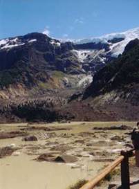
Retracing our way back down the bumpy dirt road, we took a left at the intersection heading back up a second, longer, just as bumpy dirt road toward the El Tronedor ice field. This is one of the most northern ice field/glaciers straddeling the Chilean/Argentine border. It's in this area you can find several long distance hiking trails that could afford many days, if not a few weeks of good exploration. Since we did not have backpacking gear, we headed to the two most popular stops, the Ventisquero Negro (black glacier), and the Garganta del Diablo (devil's throat not to be confused with the much larger one found at Iguacu). The black glacier is a glacier that is covered sand, rock and debris. We'd seen similar glaciers before, but this one was so well covered it was hard to believe it was ice. If it weren't for the very slow motion of the icebergs floating in the glacier ponds we could well have believed it was just plain rock. The Garganta del Diablo was a small waterfall cascading nicely down a steep precipice.
The ferocity with which Argentine drivers take to the roads never ceases to amaze us. Even in these mountains, on these rough dirt roads, they treat the drive as though they're on a super, paved highway. If you go slow, as we always did, they'll drive literally within inches of your back bumper. It's as though they believe they can push you to get you to go faster. In our short time having a car we saw one pick-up truck with a smashed front end where the driver couldn't stop before running into the side bank and another car with two flat tires where they had taken on a set of washboard bumps far too fast. So driving on these narrow dirt roads after dark with crazy Argentine drivers is not a good idea. We always wanted to get into a campground well before the sun set.
Add to that the strange traffic laws. Every town, even the smallest, has a rectangular grid of one-way streets, every other street being the same direction. The direction is noted on the sign giving the street name. There are no stop signs and few stop lights. When we rented the car a gray haired American woman, who just returned a car warned us that the car on the right always has the right of way. The problem we found is that some streets are two way, some streets seem to be more major and have the right over everyone else, and in some cases no law seems to exist at all. We hated going into Trelew, a fairly large city, and dealing with Bariloche with all its pedestrian and tourist traffic. We began to think it was simply one big game of chicken with the braver driver getting the prize. Eventually we just gave up trying to figure out the laws and assumed everyone else had the right-of-way, no matter how close the car behind came, no matter how many horn honks we got. We may have gotten a bunch of drivers quite upset, but we did not have any accidents, a bonus for Argentina driving.
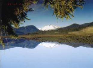
There are two long driving circuits, which are also nice on bicycles that can be combined into a single loop. The Circuito Grande heads east and north out of Bariloche around Lago Nahuel Huapi to the very small, quaint mountain town of Villa la Angostura, and then back around past Lago and Villa Traful, back to Bariloche. The Circuito de los Siete Lagos (circuit of the seven lakes) takes the same route out of Bariloche but continues north to San Martin de los Andes passing nine beautiful lakes. No one seems to know which of the nine actually count as the seven. Take your pick, they're all beautiful. On the way back from San Martin you can turn off at the intersection to Villa Traful, thus finishing the Circuito Grande at the same time. Both routes right now involve many hours driving on rough dirt roads. Although we found a lot of construction in progress and it appears that in a few years the road between Bariloche and San Martin will be completely paved. The section of the Circuito Grande going past Lago Traful will probably never be paved.
We ventured as far north as San Martin de los Andes. It's situated at the very end of long skinny Lago Lacar thrusting way into the highest mountains. Its position and the scenery reminded us of West Glacier in Glacier National Park, although San Martin is far larger. It is also very, very expensive. The $27 US price to stay at the automobile club campground quickly convinced us to simply buy sandwiches for dinner and turn back to the free park campground we'd seen earlier. Too bad as it would have been nice to explore the city a little longer. Those high season prices and the packed camping conditions just turned our stomachs. Instead we headed back to a beautiful field sitting next to a river running out of one of the stunning Lago Villarino with mountains all around and only 5 other groups of campers. This was what we were looking for.
National park campgrounds in Argentina come in three varieties. There are the free camping spots. These literally are just open fields where they permit camping. There are absolutely no facilities, not even pit toilets. The lack of toilets was a surprise, as it's hard to imagine they'd want folks going to the toilet just anywhere, leaving their paper behind. But, I suppose it's no different than backpacking. Argentines don't seem to like these undeveloped sites. Of the 6 groups we encountered, one was a Chilean family, one was a group of three European RVs, another was a large group of Isreali 20 year olds, and us. The other two we don't know where they came from, but we'd bet 10 to 1 they weren't from Argentina.
The next step up in camping arrangements is the somewhat developed sites, which cost a few pesos per person. These have running water and pit toilets. There are no assigned sites, you just pick a spot to put your tent, and there are no picnic tables. These campgrounds are much more popular with Argentines and were much more crowded.
Finally there are the top of the line campgrounds. As with so many campgrounds in the U.S. parks and forests, these appear to be run by some contracting company. They have hot water showers, flush toilets, tables, a small market, and a parrilla/restaurant. These are the most popular with Argentines. Why not? They're the most comfortable. We found getting a shower was nice, but we really enjoyed staying in the uncrowded field with just those 5 other groups.
Finishing the Circuito Grande late at night, we returned to Bariloche to spend one last night in the tent at the Automobile Club campground. Hotels are fine for a while. But it doesn't take too long before we begin to long for our own space, specifically the tent or camper. The ground under may change every night, but the structure is ours to do with as we please. Early the next morning we returned the tent, returning to hotel life once again.
We still had a full day with the car before it needed to be returned and we wanted to take on one last of the more distant tourist destinations. Just outside Bariloche is the Cerro Cathedral, which is their main ski area. In summer, as with so many ski areas, it becomes a mountain biking playground. Bikes and riders take the chairlift to the top and then hurtle downhill as fast as they can without breaking their necks on the jumps and bumps. At Cerro Cathedral they also have a cable car and chair lift combination for those who just want a ride to the top for the view and don't want to try their skills on two wheels.
For those of us looking for something active, but not quite so active, you can walk the 1100-meter climb to the top supposedly following a specific route along one of the ski path. As we were to discover both on the ascent and descent, this trail that was supposed to be well marked really isn't. There are a plethora of ski paths leading up the mountain many of which dead end in a huge, steep field full of those sticky, prickly plants that seem so attracted to my pants. We've never seen so many prickers attached to a pair of pants before. Even after 1/2 hour picking them off, dozens still clung tenaciously. It took hours of picking and scraping to get them reasonably clean and a good laundering to get most of the rest. Even a week later a few sharp points were still stabbing. Lesson learned, don't leave the path even if it requires backtracking.
At last we had to return the car. By this time we'd had enough of dealing with difficult Argentine traffic laws so it was a bit of a relief to get rid of the car after all. We had one more day to wander around and some easy walking around the Circuito Chico was sufficient following that 1100-meter climb the day before. Then it was time to start working our way back toward Bolivia and Peru.
One 20 hour cama suite bus ride to Buenos Aires, one 5 hour flight to San Salvador de Jujuy, one 5 hour bus ride to Villazon, and one additional 3 hour bus ride to Tupisa took us back to 10,000 ft, Bolivia, and the mountainous desert. Tupisa, a town located just barely north of the Bolivian/Argentina border and world away from the resort town of Bariloche, is nestled in a red desert landscape that looks so much like the territory around Tucson. Normally it's a great place for hiking, horseback riding, and mountain biking. However, this time of year rains tend to hit the valley. Each night the skies darken and a spectacular lightning show illuminates the sky. This would be fine if it weren't for the fact that the heavy rains that turn the arroyos and dry creek beds into rivers of mud. This makes outdoor activities difficult if not impossible to accomplish.
We both arrived at the high elevations with throbbing headaches. Having only passed through the altiplano for a few days on our way to Brazil a month previously and subsequently spending the next month very nearly at sea level, neither one of us was close to being acclimatized. Midnight came and Brian's headache seemed to be worse. We waited anxiously, the question being just how long do you wait before seeking medical aid. Altitude sickness is nothing to take lightly, but how long is too long. Yet, just what do you do in this case. The normal response to altitude sickness is to get lower, which was virtually impossible to do here. We'd have to wait and hope. Finally we both got to sleep.
Morning came and both our headaches were gone at last. It had been a frightening night, but at least things did not go from bad to worse. Between trying to get acclimatized to the altitude and the rains causing mud in the canyons, we decided not to attempt any hiking or biking this time around. It seemed wisest to take the day easy and just explore town at a very slow, leisurely pace.
Next stop, after another 7 hour or so bus ride over some mighty rough dirt road, we arrived at Potosi. Bolivia is gradually adding km upon km of pavement to their network of paved roads. About 100 km or more distance on the way to Potosi was a messy, bumpy hodge-podge of road in various stages of construction. Bus traffic is relegated to dodging rocks and holes in a road that often traces along the floor of creeks and streams. It's not an easy ride. Eventually, probably within 3 to 5 years, the route all the way to the Argentine border will be completely paved making for a much faster and easier trade route, something landlocked Bolivia really needs. For now you just grin and bear it.
Towering over the desolate landscape surrounding the old colonial city of Potosi stands what was once the greatest silver find in the history of the world. Local legend says this mountain, called Cerro Rico by locals, was discovered by a trader who was searching for a missing llama. As night approached and the llama continued to elude him, he started a fire to keep warm. The fire was so hot it melted the underlying vein of silver leaving a hard shiny substance, silver. From here there is disagreement among various versions of the legend as to whether the trader informed the Spaniards of the discovery or if some one else did. Historical records claim that the Spaniards found the silver after an extensive survey of the area. Either way, the discovery was monumental.
Cerro Rico is a single mountain that contains virtually every mineral known. Geological studies have revealed that it is an old volcano core. This particular volcano did not exhibit an explosive behavior that expulsed lava, ash, and rock far and wide. Rather, everything stayed close to the core yielding this one mountain of densely packed minerals.
The mountain was discovered back in the 1500s and mining began almost immediately. Local indigenous tribes were used extensively for the underground mining operations while black slaves were shipped in for the above ground ore processing and coin manufacture. Conditions were brutal both above and below ground. It is estimated that over 9 million indigenous and blacks died for the Spanish greed for riches, although not all these deaths were due to mining related causes. For the next 400 years this single mine almost literally supported the entire Spanish Empire as the crown spent and squandered the riches. A tour of the main palace in Madrid, Spain reveals where many of these riches went; amazing tapestries, buildings, furniture, paintings, and treasures.
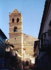
Not all the riches went just to Spain. The city of Potosi, an anomaly that sprung up in the desolate, high altitude, mountains of what is now Bolivia holds public and private buildings also built from the resources of this silver mound. Hence spectacular colonial structures abound throughout the central old district. There was also the funding of the famous Potosi school of art, examples from which can be found throughout South American museums. And the old Spanish mint, a huge and well-restored building occupying an entire city block. It's a treat to wander Potosi's old historic streets.
Potosi is a city of extreme elevation. It's the world's highest city, over 4,000 m. It boasts the world's highest commercial airport, which when we visited was not seeing any air traffic due to a slight crash of one of their planes. You could say that it is quite literally a breathtaking city as each and every small climb leaves you huffing and puffing. Every now and then I would realize that I was forgetting to take deep breaths. It would feel as though I was ready to suffocate before I'd remember to take a long, deep breath.
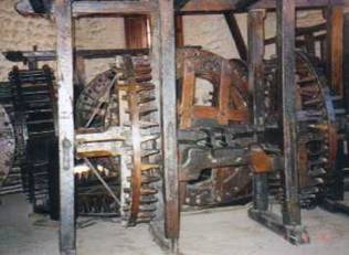
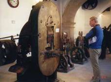
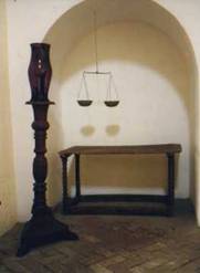
Following a major renovation, the former mint has been converted into one of Bolivia's best museums. The first coins minted in Potosi were essentially pounded on a stamp using a hammer. The result was an odd shape flat piece of silver with some semblance of a design on the face. The value of the coin was based on the total weight. However such a coin could easily be modified. Snip a little piece off, you keep the piece and the next fellow has no idea his coin is not quite up to standard weight. Needless to say these coins kept getting smaller and smaller over time. In later years the circular coin was introduced to avoid this type of forgery.
When Bolivia gained its independence in the early 1800s, the president decided to modernize the mint. Coins were now rolled, cut, and stamped using modern steam powered machines. Most came from Philadelphia, PA, home of one of the U.S.'s major mint. In the 1940s these steam machines were replaced with electric versions. Interestingly even with the most modern of the electric machines, coins were still made basically one at a time. An operator literally placed a single circular blank in the machine and pressed the button for a stamp. The one coin popped out. Compare that with today's high rate, multi-stamping process, which produces thousands of coins at a shot.
In the end the silver coming from the mine simply could not keep pace with the coin needs. With over 400 years mining, it has to figure that the easy ore was long since extracted. In 1969 the mint closed its doors for good and Bolivia started importing its own currency. Ironically, small denomination coins are now made in Spain, five Boliviano coins come from Canada, the two toned gold and silver looking all to much like the Canadian Loonie, and bills now come from France. With this expensive importation of currency, its no wonder bills tend to be used until they are very nearly shreds.
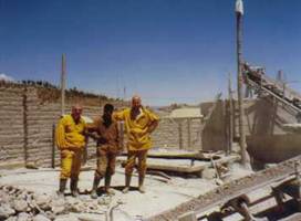
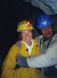
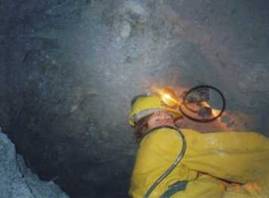
One of the primary reasons for visiting Potosi is to take a tour of one of the mines. Although silver extraction has tapered off significantly, there is still sufficient mineral wealth available to allow for some profitable enterprises. Major corporations still extract zinc, lead, silver, gold, etc from certain locations on the hill. Yet there are also a number of private individuals plying their mining trade deep within the bowels of that enormous hill. These private miners have joined together to form various cooperatives, such as the Grito de la Piedra (scream of the rock). Deep within the cavity of the mountain these hardy souls strap on their acetylene lamps, pick up their mallets and digging bars, and set to work. Half the day is spent hammering away at the rock to dig a hole just big enough for a stick of dynamite. An explosion is set off, the rubble dug out, and the whole process starts again. It's a mining method in use for centuries with virtually no change.
Safety devices are nonexistent for these hardy miners. They had no helmet, no respirator, no goggles, no steel-toed shoes. They are independent members of one of the 10 or so cooperatives still working the mountain. Often they start their labors quite young, as children, despite laws to the contrary. Silicosis of the lungs usually brings that career to a quick halt within about 10 years. Alfredo, one of those so afflicted, has had to find other means for earning a living, tour guide. Pay for the youngest miner averages around 10 Bolivianos per day, or about $3. A more experienced miner might, with luck, get up to 20 B per day, but the average remains around 15. It's easy to see why a gift of a single stick on dynamite and a fuse, costing us 10 B, is considered so valuable. We also gave coca leaves, a bottle of soda, and some cornbread, all of which were eagerly accepted.
Tios also stands for Uncle in Spanish. The miners consider their Tios to be a member of the family, kinfolk.
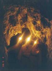
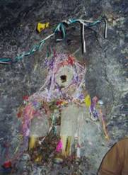
After the republic was formed, the Tios of their imagination took on a reality in the form of these home made statues placed within the mine tunnels. They're given very Spanish characteristics, white face, beard, hairy chest, all to equate the Spanish with the devil, which with the horrible treatment of the indigenous is easy to understand why.
Each Tios has a unique name. We visited Tios Jorge, not related to George Bush. Each is venerated on regular occasions with the presentation of a cigarette for his mouth, coca leaves at his feet, and alcohol poured all around. Presentations are also given to Pachamama, mother earth, for whom a more natural statue is also constructed. Pachamama is believed to be responsible for providing the ore so sought after. Tios is responsible for helping the miners find it. If either deity is unhappy, the ore won't be had.
Coca leaves are an important part of a miner's daily life. Originally coca leaves were the exclusive property of the priests. They chewed the leaves to help bring about the trances and hallucinations they needed to contact the gods. Royalty also sometimes chewed coca. Many of the ancient ceramics and pottery statues show priests with a single bulging cheek, a sure sign of a "coquero" as they are called. In colonial times leaf chewing of spread to the common folk. Miners found it would alleviate hunger and give them strength to continue working well beyond normal physical capacity. The crown at one time wanted to ban coca chewing, but quickly realized this would adversely effect output. Consequently the authorities tended to look the other way. Leaf chewing continues to this day. They are chewed in huge wads stuffed in the cheek making an obvious bulge and easy way to identify a "coquero". The black spittle seen in the corner of our old miner's mouth was from that wad of coca.
The choking stench of the acetylene torches, the slimy feel of gooey mud, the clammy feel of the humid underground left us anxious to get back above ground and into the sunlight. Black goo seemed to emanate from our noses and was embedded in our hair. Even a shower did not leave us feeling entirely clean. We were underground for such a short time, yet imagine having this as your life's work. No thanks. As is so often the case, we once again were extraordinarily grateful for being born where we were.
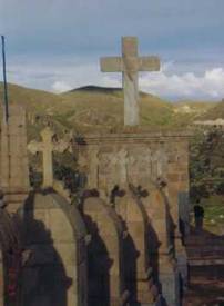
At about age 15 or so the second daughter of a family of wealth, if accepted, shed her outside worldly goods and identity to permanently enter this abode. She would never again see her family or the outside world. Not even her face could be shown to anyone outside, not her parents, not a priest, and not a doctor. In fact she was not even permitted to see her own face. Despite many gifts of mirrors made from pure silver, the nuns were required to keep their faces entirely covered whenever within sight of these gifts. Only other nuns could view the girl's face.
Gifts, only small items usually consisting of food, could be given through a small hole, again with the nun holding an odd spoon shaped item to her side without showing her face. Conversations with parents were held with a solid wall in between and a row of elder nuns eavesdropping in the background. Deliveries of external goods needed for daily living were placed on a revolving tray with walls preventing exposure. Large items were delivered into a garage size waiting room with all nuns absent. A bell was rung, the door closed, and a receiving nun would exit from the small closet within which she had hidden to take account of the goods. All nuns were required to stay within their small quarters whenever any exterior person was within the convent for doing such things as major repair work. Doctors were called only when the nun was on her deathbed, if at all. Even priests were allowed to enter only upon the death of a sister and only to perform last rites. The bodies were packed in lye and buried under the nun's private chapel, thus not even leaving the premises after death.
Self-punishment and rigid discipline seemed to be the order of the day. Clothing was light and their feet shod with only rope sandals even in this very cold altiplano environment. Flagellation or the wearing of spiky metal underwear was the norm. For some reason they believed that suffering was the only way you could come closer to God. They were given only 2 hours per day during which they could work on their own creative projects and speak to one another. For the rest of the day they worked on chores needed to keep the convent running, cleaning, cooking, etc, all solitary with not a word to another sole. Communication was by hand signals only. Imagine doing that to a bunch of women.
Throughout the early years of the convent about 40 women lived and existed in this environment from the time they turned 15 until they died, often at an age of around 60 or so. In 1969, however, these restrictions came to an abrupt end. Under orders from the Vatican, the nuns were forced to ease up. They now can use mirrors, they can see their parents through a lattice work partition, they can go out to see doctors or shop for needed goods. Self-punishment is no longer a fact of daily life. It's a much freer life. Yet, the number of girls entering the convent has been drastically reduced. Only about 10 still exist, the youngest being 18, the oldest 80. Times change. Opportunities in the outside world for women in particular are far better than before. So it's easy to see why the convent enrollment is low.
Carlos Mesa, the then president of Bolivia, had a little bit of a problem. Unfortunately this little problem effected a lot more than just Carlos Mesa. It affected the entire country, including visitors. Despite being a fairly popular president with most of the population, mostly because his was one of the few Bolivian governments not taken to systematically looting the federal treasury, small groups of socialist oriented campesinos (peasants) had decided to bring the country to a standstill. In a landlocked country having only a few paved routes leading into the major cities, this is fairly easy to do. Simply build blockades from rocks, boulders, and large concrete chunks strategically placed along the road. Viola! Trucks don't move. Buses don't move. Tourists get stuck.
By the time we reached Potosi the blockades had been going on for nearly a week. Potosi itself was not effected. Neither was Oruro, a city on the direct path to La Paz. However, all four access roads into Sucre, home of Bolivia's Supreme were blocked by blockades over 15 km long. Tourists stuck in the city were forced to resort to chartered air flights to get anywhere. We had wanted to visit Sucre after Potosi, but having heard this news we quickly gave up on that idea. The two paved routes into La Paz were also blockaded, but we heard rumors that buses were getting in and out at night. Things were not looking good.
Options were limited. We could backtrack to Argentina, try for a bus over to Chile, and then head north toward Lima. This, however, seemed like a long arduous route and with our departure date rapidly approaching, it was not an ideal solution.
Another option was to head to Oruro since it appeared that that section of road was clear. From Oruro we could either head down to Arica in Chile, another route that was still open, or see what, if any, possible chances of getting to La Paz might be. We headed to Oruro.
In Oruro we were promised, absolutely guaranteed that our bus would go all the way into El Alto, the high city just above La Paz. Even though all the other bus companies promised only to go as far as the outer suburbs of Ventanilla, our company promised we'd go further. So why was it we found ourselves at 10:30 PM tromping along the main highway around the boulders and concrete blocks for 45 minutes from where the bus unceremoniously dumped us out at Ventanilla to El Alto. This was not the first time that Bolivian bus representatives have given us false information. Lesson learned, take whatever they tell you with a huge grain of salt.
El Alto is not one of your safest areas. We'd ridden our bikes through it one time earlier and were far too happy to finally get down to La Paz proper and tucked into the safety of a hotel. And that was in broad daylight. Now here we were walking along the road through this same city in the dead of night. Another man, a resident of El Alto, walked by our side giving instructions as we went along. "We have another 30 minutes to go." he'd announce, "10 minutes more." as we got close. We watched his every move and stuck very, very close. We wound our way around large rocks, nearly walked into a barbed wire fence, stepped over burned tire remains, tip-toed quietly past a large group meeting for the indigenous protesters. Our companion ignored the taxis and trucks all offering rides and pushed onward. We followed close by. Finally we reached the first spot where the mini vans picked up passengers. He told us to get on, take the bus to the end of the line and there we'd find another bus going downhill. What a relief it was to get into the safety of that bus. What a relief it was to find another bus waiting at the end of the live. What a surprise it was to find another woman from our same original bus, one who had accepted the over priced taxi ride, sitting on the same bus. Walking hadn't been so bad after al.
La Paz is a city we actually rather enjoy. Even though it's very busy in the older district, we've never felt uncomfortable. Crime does exist in the form of snatch and grab just as it does in cities the world over. But, we've not heard of muggings or armed hold-ups at least not in the central area. Our hosts at the hotel mentioned that sometimes, in the upper reaches of the city, petty crooks snatch fancy earrings right out of women's ears, ouch! Otherwise crime is not usually violent. By leaving all valuables in the hotel and carrying only a day's worth of cash, we never felt ill at ease even at night.
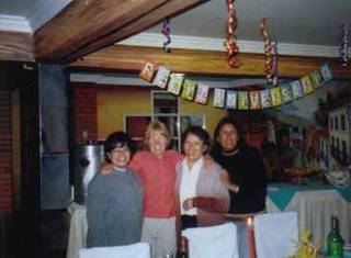
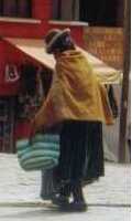
La Paz is the most cosmopolitan city we've seen in Bolivia thus far. Although we do hear that Santa Cruz has taken over as the happening place for up and coming Bolivian professionals. La Paz offers an interesting blend of upscale shopping, restaurants, and hotels right alongside the more traditional trappings of an Andean city. Women dressed in their traditional highly gathered calf length skirts, their heads topped off with the old fashioned English style pork pie hat, manage all sorts of sidewalk kiosks selling everything from food to sewing kits. All this takes place at the doorstep of modern shopping malls. It's a fascinating and lively place to wander and it made a great place to stop for a birthday celebration.
Our favorite hotel in all of Bolivia and possibly all South America is the Estrella Andina Hostal in downtown La Paz. We'd happened upon this little gem of accommodations the first time we visited La Paz just by accident. Located right next to a more expensive option frequented by the tour groups, this little hotel was left out of the early guidebooks. After our first visit, we rectified this oversight by sending a letter to the publishers and now they are listed. The staff of this hotel is the most friendly and hospitable. Some of the long-term employees even remembered us from our first biking visit. We were given a reasonable rate, $20 per night, including a fabulous breakfast buffet of fruit, cereal, bread, yogurt, juice, and coffee or tea. It's the best deal of all hotels we found in La Paz.
Yet even all this pales when it comes to the rooms. This is what really sold us. Every room has over an entire wall a hand painted mural. Each is a unique representation of some early aspect of Bolivia. Usually it's a street view of some colonial town with folks dressed in traditional outfits. Some are natural scenes of the surrounding mountains or the lowland jungles. Only one mural on the top floor shows a modern La Paz scene. Everyday it was a treat to peek into each room to see each and every mural. They are fabulous.
This was our third stay in this hotel. It was beginning to feel as comfortable as a pair of old shoes. We knew the staff, we knew the rooms, and we knew the neighborhood. So we decided to present these folks with a small party. A birthday cake for me with the friendly staff of the hotel made for a perfect little celebration. After a wonderful dinner in the far more expensive hotel next door, we returned to find Ilse, Gladys, and Maria, hanging streamers and a "Feliz Aniversario" sign from the ceiling. Two bottles of Bolivian red wine sat on the table, one was a gift for us to keep. Plates and the cake sat nearby. We had a wonderful evening. Spanish was the language of the night. Brian had to be satisfied with as much as he could understand, but he did get the gist of most topics. We talked about everything, politics to local traditions, laughed, and had a great time. It was so nice, for a change, to have company for a birthday. It seems so often we are alone, just the two of us. All too soon the night came to an end. We left the remaining cake for the rest of the morning staff, the majority of the cake at that, and headed to bed.
Getting out of La Paz was not quite as difficult as getting in. At 7 in the morning a minibus stopped outside the hotel door and we climbed aboard. This had been arranged the day before, of course. During these of blockades this tour bus transportation to Copacabana would leave at about 3 AM, a time when the blockaders were asleep and the buses could sneak around. This day, however, all looked clear for getting out.
The route was clear, sort of. Just before the intersection where one has the option of heading north to the resort town of Copacabana on Lake Titicaca or heading to Desaguadero on the Peruvian border, there is a single bridge crossing the disgustingly polluted Rio Seco. This bridge was the objective of a group of blockaders. They were gathered in large numbers right in the center of the bridge and there was no way anything was going to get by. As I watched several of the indigenous women toss rocks at our particular bus, which had "turismo" emblazoned on the side in huge letters, I was so glad to be inside rather than out. These folks were in no mood for foreigners, especially folks from the U.S. since they blamed the U.S. for most of their problems. As the bus came to a stop and we eyed the mass of people on the bridge we couldn't help but wonder if this would be as far as we could get for this day.
Fortunately our bus driver knew a back route and wasn't afraid to take the rough dirt roads. Just follow the taxis. We bounced and bumped over some difficult local streets through parts of El Alto rarely encountered by anyone but locals. Eventually we found another, much smaller, bridge over the very same disgustingly polluted river. From here it was just a few more bumps and bounces to the pavement and we were on our way. There were no more blockades from there to the Copacabana and the border. Amazingly, that bottle of wine tucked between my clothes in my bag on the bus roof made it unscathed.
There was one event we just had to see. Within the town is an enormous cathedral of a most unusual Moorish design. On one side is a long, narrow tunnel enclosure with black painted walls covered with the wax of thousands of candles. Within this tunnel rests a venerated statue of the Virgin Mary. It was carved by the grandson of the Inca ruler, Altahuapal, and is said to produce miracles from time to time. During Semana Santa, a time that we would fortunately miss, thousands of pilgrims flock to Copacabana just to see and ask for favors from this statue.
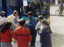
During the rest of the year, however, the town plays host to a different most unusual custom, the benedicion des automoviles. Everyday at around 2 PM or so, people with new vehicles, or at least vehicles that are new to them, come to the cathedral to have them blessed. They decorate their autos, vans, or even large buses, with streamers, banners, ribbons, and bows. A priest or lay person from the church comes out with a bucket of holy water. He says a blessing and scatters water all over the place, outside, inside, even in the cargo holds. The vehicle owners break open bottles of champagne or beer, well shaken of course, and spray that all over the outside. Not the inside thankfully. Sometimes confetti is thrown everywhere. Photos and videos are a must. Nighttime parties are probably in order as well. So once we saw this we learned to always look for buses that proudly displayed the "Benedicion de Copacabana" banner. These have to be the good buses.
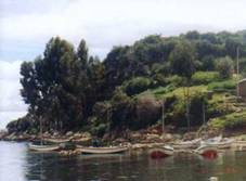
Disembarking from the small, unbelievably slow, boat at about 11 AM, we immediately headed for the small museum, very, very small museum, and then off to the Inca ruins. They're not huge and appear more like a labyrinth of rooms, but they do show some of the masterful Inca stone work found in more elaborate ruins such as Machu Pichu. From here we took off southward along the amazingly wall cobblestone walkway. It was a spectacular walk along the high spine of the island with 360 degree views of the lake and island villages. The terrain is easy. Only the elevation gets the heart pumping.
Getting lost was nearly impossible. Arrows painted on the rocks pointed to sud or norte. Even food and crafts could be purchased. Along the way we found one enterprising woman selling cheese sandwiches just when we were beginning to think lunch would consist of only cookies. Her position was perfect. The locals were friendly, obviously recognizing that having tourists hiking along the trail was a huge boon to their local economy. We even passed a point where men worked diligently with pick and shovel toward finishing the very last section of cobblestone. Only the children seemed a little ruined by the tourists. Far too many asked for caramels and one wanted my hat as a gift. It's unfortunate that the tourists so blithely give kids these gifts without thinking of the consequences of their actions and how it changes the local culture. We told them we had nothing to give and continued on.
With so much time to spare, we had the opportunity to wander further toward the most southern tip of the island. Here we discovered an old native woman's secret hiding place. She sat, quietly, facing a magnificent view of the mainland. To one side sat the usual colorful carrying blanket. As she sat in absolute silence, she worked on a sewing project. Being careful not to disturb her peace, we retreated to a nearby rock and sat to enjoy the view ourselves. This woman had found a little piece of heaven, away from the tourists and children. We could share it, but still let her keep her peace.
Time was running short. We had but a little over a week left and two places we wished to visit. Early the next morning we began the process of working our way toward Arequipa. First there was a mini but to the Peruvian border, easy to accomplish. Then a second mini bus to the next town. A short walk of about 4 blocks got us to where more minibuses to Puno waited. Once in Puno we bought tickets for Arequipa. Leaving at 3:30 PM, we could expect to arrive at about 9:30 at night. It would have been nice if that had been our last long bus trip, but even after all this distance, one long ride still remained.
Arequipa, a city of about 800,000 inhabitants, seems to sprawl out forever. Most of the surrounding neighborhoods are pretty bleak and depressing. Only the old, central district holds any attraction. I recall our stop at Arequipa about 1 1/2 months earlier when flying to Puno. The location of the airport is in such a run down area of the city that I had serious doubts about even stopping for a visit later on. Yet the central district, right around the main square, is a surprising delight. The plaza has a beautifully restored cathedral all along one side and full colonnades on the three other sides. It was far more beautiful than we ever expected. And there were two must see attractions we just couldn't pass up.
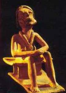
The Inca's worshipped the mountains. The mountains provided the precious water. So naturally the mountains must be where the gods resided. Sometime in their development they came up with the idea that in times of crises, such as in a drought or when a volcano is erupting, these mountain gods had to be appeased. There seemed no better way to placate the god's anger than to offer the sacrifice of a young girl or boy. Hence atop many of these mountains, right at the peak, modern day archeologists find the mummified remains of one or more of these sacrificed children carefully wrapped and surrounded by a variety of ceremonial objects. The extreme dry, cold climate at those high elevations preserves the mummies in remarkably good condition. Thus far 20 of these child mummies have been found and recovered.
One of the most famous is the Ice Maiden known affectionately by the locals as Juanita. In 1995 her remains were discovered high atop Mt. Ampato. During this time nearby Mt Misti, considered to be the most dangerous volcano in the world, was spewing forth dust and ash. This ash covered the peak of Mt. Ampato and melted the top snow. It's during such episodes that archeologists know the chances of finding mummified child sacrifices is greatest. They also know that the grave robbers know the same thing. Time is of the essence. Within just 2 months of finding and retrieving Juanita, the climber/archeologist team returned to the mountain to discover two more such burials, slightly lower on the peak. It was truly a remarkable find.
The remains of Juanita and the other 19 children are kept in the city of Arequipa in a museum run by the local university. Juanita herself is on display only 8 months of the year. We learned that the temperature in her display case is not sufficiently low to keep ice crystals from getting inside her body and clothes. So for 4 months of the year they place her in a crypt with a much colder, drier environment to essentially dry her out. In her place is shown a very poor, wooden replica. Unfortunately for us, we happened to visit the museum when only the model was on display. Fortunately they do display one of the other mummies at all times, one of the ones not having such unique value. What makes Juanita so valuable is she was so well preserved her body still contains all the fluids of a normal body. The other bodies are so desiccated and dried, there's nothing much left inside. For science, these fluids are considered priceless.
Our tour guide was enthusiastic, informative, and just plain good. Her English was excellent and she didn't even mind an occasional small correction as well as a bunch of dumb questions. Of course, having the tour guide all to ourselves made all the difference in the world since we could have her undivided attention. She explained some of the most minute details about all the incredible items found with the children. She explained how they believe the ritual took place, how the girl was killed, how she was plied with coca leaves and chicha beer to dull the pain. It was a most informative tour, well worth every Sol. This museum alone made the trip to Arequipa worth the effort.
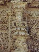
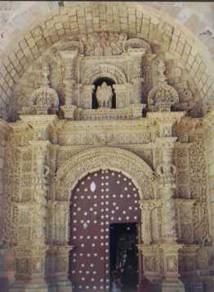
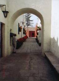
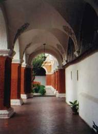
Yet one other tourist destination adds to the value of Arequipa. Covering a very, very large block of the old city is another one of those convents of the Carmelite nuns. This convent, however, has a rather different history. It was founded by a very wealthy widow, who could not or would not give up the good things in life. Upon entering the service to God she decided to take with her a bunch of servants and slaves. The novitiates she selected all came from very well to do families and they all came with servants in tow. For 300 years the nuns entering this convent basically had a good time behind closed doors not living anything like the chaste existence nuns were expected to maintain. It took the intervention of the pope and a new, strict head nun to finally straighten out the whole lot of them.
Meanwhile the 450 nuns, servants, and slaves lived in and built the most amazing and hodge-podge convent structure. Housed within a maze of meandering walkways are dozens of rooms, each unique and special. Most consist of what appears to have been a small kitchen attached to a combined sleeping living space. Some of the larger rooms have a sleeping space separate from the living space and an enclosed patio. These rooms looked virtually palatial when compared to the spartan and tiny rooms found in Potosi. The accoutrements used by the nuns looked equally extravagant.
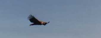
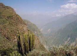
Northeast of Arequipa, over a high mountain pass, is a road leading to the second deepest canyon in the world, Canon del Colca. Getting there on bus entails a five-hour ride each way over a mostly rough dirt or poorly maintained paved road often on a bus whose suspension is well beyond battered. The canyon is beautiful. Although its appearance seems more like an area surrounded by high mountains rather than a canyon. If you saw it from the air it would probably look much more like a true canyon. Yet, few tourists come to this area to see the canyon. It's the South American condor they're here to see.
The normal two day tour to Canon del Colca consists of getting on a mini bus, riding to the canyon, visiting a hot springs resort, spending the night, visiting the condor viewing platform for an hour, and then riding all the way back. Tours lasting just one day start out very early in the morning, drive like crazy to spend the hour at the condor viewing platform, and then drive like crazy just to get back. Consequently there are tourists grouped at the Cruz del Condor viewpoint for only a few hours each morning. After about 11 PM everyone is gone.
Rather than head off on this whirlwind tour, we decided to take our time. We headed deep into the canyon to stay at the town of Cabanaconde another 1 1/2 hours down canyon from Chivay. This is a very, very small town that has seen only a modest benefit from the tourist influx to the canyon, primarily because the big tour companies don't go this far. They go as far as the condor mirador and turn around.
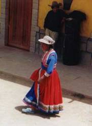
Women in Cabanaconde still wear the traditional clothing, but a far different form of dress than anything we'd seen before. Colors of skirts, blouses, and hats are extravagant and bright. They wear 2 layers of floor length skirts, usually of contrasting colors, with the front section of hem of the outer layer tucked into their belt. Their hats are amazing. Made in Cabanaconde and only worn there and in a couple other surrounding towns, these leather hats are usually completely covered with embroidery, top, brim, and underneath. I couldn't help admiring these hats and was often encouraged by the locals to buy one to take home. But, it just would not fit in most other places. I had to be happy with just a photo.
Very early in the morning, at 7AM we set out on the rickety old bus for the condor overlook. The bus was packed with farmers carrying an odd assortment of tools out to their respective plots. A few women dressed in especially fancy versions of the local dress were also headed out to the overlook to sell crafts. We bounded off the bus at the mirador, ignored the whistles from the local tourist tax collector, and headed on down the road. We'd been told that we could easily get a view of the condors at other locations where the tax was not enforced. We doubled back and soon found a spot where we got some spectacular views.
We'd made the mistake of not finding out what the bus schedule back to Cabanaconde was. In the morning we'd seen a bus heading in that direction about once per hour. So we assumed that'd be the case for the entire afternoon. Not so. It turns out buses pass by until around 12 noon and then there are no more until around 4:30. We'd missed the noon bus and had not brought enough water to hike the entire 2 1/2 hour walk back. So we waited and waited and waited. Fortunately, we did have those condors and a plethora of other birds to keep us company, the view was outstanding, and we did get to take a bit of a walk through the fields. So it was not that bad. It's just that lunch was mighty slim.
Our return to Arequipa was aboard one awful bus. At least the bus we'd taken out a day earlier had descent suspension. This particular bus, the one leaving at 8AM with all the farm workers aboard, was in really tough shape and we felt it. Every bump, bounce, jostle seemed to vibrate right through the frame and into the seat as if there weren't a single spring or shock on board. There might not have been at that. I couldn't help but worry the entire way back. That bottle of wine I had carefully taken from La Paz to Copacabamba and then on to Arequipa still sat tucked deep within my pack between layers of clothes. But, would this particular ride prove to be too much. Hours went by. Pictures of a red wine stained and smelling pack flooded my mind. Maybe we should have drunk it after all. When we finally arrived in Arequipa, far later than expected, we rushed over to the hotel and I immediately checked on that lone bottle. Much to my relief, it has once again survived. That's one thing we've found, clothing works really well for protecting breakable objects.
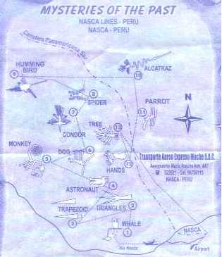
There was one more stop we wanted to make before heading back to Lima and our airline flight. Nasca the town is located a couple hundred miles south of Lima, inland from the coast by about another 20. It rests on a high plain that acts almost as a wide step between the Andes and the coast. The town itself has virtually no claim to fame. It's the famous lines drawn across the nearby desert plain attract all the tourists.
Ancient peoples living within the region of this grand plain viewed this large flat surface not as a good area for building or cultivating. Rather they seemed to view it as a huge writing tablet just waiting for an author. It is on this large plain that you find the world famous Nasca lines scrawled out for miles upon miles.
Between about 800 and 400 BC, native peoples came up with the notion that they could create huge designs on the plain simply by moving aside rocks. Rocks of the upper layers were coated with the dark surface known as desert varnish. Rocks not exposed to the sun and air are much lighter. They subsequently built hundreds of straight and curving lines all across this plain. Some of these are just long, straight, narrow lines running for miles and miles. Some designs are huge trapezoids, sometimes two in parallel, sometimes set apart. But, the most spectacular are the lines that create huge figures. A spider, odd human, humming bird, tree, monkey, and condor are some of the more famous of these designs. Yet each and every one can only be viewed in its entirety from the air.
Once the Nasca culture failed and others took its place, the existence of these lines and their purpose was lost. For ages these mysterious lines lay right underfoot, yet no one knew they were there or at least that they were important. It wasn't until the 1920s when the first commercial airline traffic passed over this region were they rediscovered. Passengers started reporting seeing strange figures drawn out on the desert floor. These reports eventually attracted the attention of a German mathematician, Maria Reiche. She moved to Nasca, becoming a lifetime resident, and began to explore, map, measure, and describe these lines. It was through her work that the unusual figures began to come to light. She realized that these were not just straight pathways across the desert. They had some sort of specific meaning and purpose. But what? Why would an ancient culture with no access to airplanes or with any nearby tall mountains build these monumental figures that could be appreciated only from the sky.
Many theories, some reasonable, some not, have been proposed. Perhaps one of the most outlandish is the idea that the straight lines are landing strips for UFOs. Another idea was that it was some sort of gigantic calendar, an idea proposed because one or two lines pointed directly at some noteworthy stars. However, with so many stars easily seen on this high, dry plain one could say that any line pointed at any star. In fact, astronomers have run computer simulations and have learned that there simply is not that great a correlation, not now, not in the past. So what could be their purpose.
We came to Nasca to not just see these lines for ourselves from the passenger seats of an aircraft, but also to learn more about what the current thinking might be. A very interesting video presented as part of our flight tour seemed to come up with a most plausible explanation.
They first looked at a most unusual characteristic of the animal figures. Some, such as the condor, may be seen in the desert. But the monkey? That's a jungle animal. It is highly likely that these figures had some sort of religious connotation. But, that has to be proven. So to find some answers to this question, researchers have headed into the deep jungles to speak with shamans who today still practice their art. Immediately upon seeing the figures they knew that these figures, these animals, hold important standing in shamanistic ritual. The animals are thought to have specific traits that the shaman can adopt when in a drug induced trance. They feel they can soar with the gods, just as the condor soars. So are these lines intended to be seen by the shamans as they soar in their drug induced trance on their way to reach the gods?
But why so many straight lines? Across the Nasca plain stretch many underground aqueducts built by the Nasca and their predecessors. They were intended to provide the most precious commodity, water, to the communities and the fields. Today many of these aqueducts are still in use and still maintained by the surrounding community. Yet back around 400 BC there was a long period of drought, about 40 years. It is also during this time that the construction of new and more elaborate lines hit its peak. Is there a connection?
Maps made of the lines relative to their surrounding geography seems to bear out some confirmation of this. Many lines appear to connect small hills on the plain with openings in the aqueduct. Other lines appear to radiate outward from a single small hill, a hill that seems to almost replicate in miniature the much grander mountains in the distance. Mountains were believed to be the source of their water. So it's just possible that these people were using the small hills as representations of the mountains. The lines drawn from the mountain to the aqueduct may have been their way of asking the gods to bring water from the mountain to the aquifer. It was a desperate plea from a desperate people for their gods to have mercy and give water. Did it work? Evidently not as the Nasca culture collapsed and it's believed drought played a major factor in their decline. Their lines, no matter how large and extravagant, just did not gain the favorable attention of the mountain gods.
Our flight over the lines was aboard a Cessna Centurion, 5 passenger, single engine prop airplane. Our pilot was about 24 years old with 6 years flying experience under his belt. He loves to fly and is thrilled to have the opportunity to hold this particular job. We'd been told that the Peruvian government requires inspections and engine rebuilds at regular intervals. We just had to trust that our particular company followed the rules. Flights last about 35 minutes and take you on a fast, whirlwind tour of each of the main figures. Each is circled twice, once with the figure to port and once to starboard. The dipping, banking, and maneuvering made in this small plane can be somewhat bothersome especially for those of us stuck in the back seat farthest from the center of gravity. However, it sure was fun to be aloft once again.
At several thousand feet altitude, it was nearly impossible to gage the size of these figures without some sort of relevant scale nearby. We just had to assume that since they could so easily be seen from this height, they must be really, really big. It was also rather difficult to spot them, with the plane bobbing around and the exact location known only to our pilot. Yet we did manage to see each one if not the first time around, the second time. They truly are amazing to see in person just to say you've been there. But, perhaps pictures we've seen in videos, movies, books, and postcards provide much better views.
The surrounding plain was as interesting to see as the figures themselves. It was particularly interesting to see the huge sandy washes where clear evidence of flooding from the nearby, presently dry river happened. I seem to recall that during one of the more recent El Nino events there was so much flooding some of the lines were either destroyed or threatened. Evidence of this flooding now appears as a rippling river of sand, almost frozen in time. Fascinating.
Maria Reiche spent most of her life trying to unravel the mysteries of these lines. She died in 1992, the mystery still unresolved. Yet if it hadn't been for her, the town of Nasca would still be floundering in complete obscurity along with so many other Peruvian desert communities. Hence, the town feels it owes much to this German mathematician. They've named the airport in her honor. Her funeral is still remembered as a big town event. The folks we met who knew her still talk fondly of this woman. Many town folk thought she was crazy at first. Now she's revered as a local heroin. We met the man currently in charge of the organization dedicated to preserving the lines. He told us in his many conversations with Maria she said it was the fact that the Nasca were following mathematical principals supposedly discovered or defined by such folks as Newton that made her want to spend her life studying them. More power to her.
We returned to Lima, Peru for the forth and final time. We had just one day remaining to see anything we felt we must see. It is highly unlikely we'll ever return to Peru so this was it for Peruvian sites. What we chose was the Museo de la Nacion. We'd visited it previously on our first visit to Lima. But, now we'd actually seen many of the historic sites discussed in the museum. So now it would have more meaning. As far as archeological museums, this is perhaps one of the best in South America. It covers essentially all the cultures that developed within the current boundaries of Peru. Many priceless objects are displayed, some original and some reproductions. It has four levels and each level covers a different period in time. Yet even with all this exploring throughout Peru's different regions and archeological sites, we still have difficulty placing cultures in their proper historical time and location. Peru has a complicated preColumbian past. To fully understand it would require much more time and study than we intend to spend. Instead, we enjoyed one last look at the amazing Moche pottery, the Nasca weavings, the Senor Sican tomb, and the fantastic royal retreat of Machu Pichu.
It was time for us to go.
Appendix A - Route
Unless noted prices are total for two.
February 27, 28 - Bus Bariloche to Buenos Aires ($108.47 total) February 28 - Plane Buenos Aires to San Salvador de Jujyuy ($214.03 total) March 1 - Bus Jujuy to La Quiaca, Villazon to Tupiza, Bo, p/40 ($13.94), B/20 ($2.48) March 3 - Bus Tupiza to Potosi, b/50 ($6.21) March 6 - Potosi to Oruro, b/50 ($6.21) March 7 - Oruro to La Paz, B/50+3.5 mini bus ($6.65) March 10 - La Paz to Copacabana, B/50 ($6.21) March 12 - Copacabana, BO to Puno, PE, B/8 + S/10($1+$3) March 12 - Puno, PE to Arequipa, PE, S/60 ($18.75) March 14 - Arequipa to Cabanaconde, S/30 ($9.38) March 16 - Cabanaconde to Arequipa, S/30 ($9.38) March 17 - Arequipa to Nasca, S/60 ($18.75) March 19 - Nasca to Lima, S/60 ($18.75) March 22 - Lima to Atlanta, USA
Appendix B - Hotels
Prices typically for a room with private bath and double bed.
ARGENTINA
Feb 20 - Camping Nahuel Pan, Esquel, Arg p/12 ($4) Feb 21 - Camping Rincon del Sol, El Bolson, Arg p/14 ($4.82) Feb 22 - Free camping along Circuito Grande Feb 23 - Paid camping toward El Tronedor, p/16 ($5.51) Feb 24 - ACA Camping La Selva Negre, Bariloche, p/20 ($6.90)< Feb 25, 26 - Hotel in Bariloche, p/80 ($27.60) Feb 28 - Hotel Avenida, Jujuy, Arg, p/50 ($17.42)
BOLIVIA
Mar 1, 2 - Hotel El Mitru,Tupiza, B/120 ($14.91) Mar 3 - Hostal Santa Maria, Potosi, B/90 ($11.18) Mar 4, 5 -Hostal Carmelita de Jesus, Potosi, B/90 ($11.18) Mar 6 - Hotel Bernal, Oruro, B/90($11.18) Mar 7, 8, 9 - Estrella Andina Hostal La Paz, B/160 ($19.88) Mar 10, 11 - Hotel Gloria, Copacabana, B/160 ($19.88)
PERU
March 12, 13 - Hotel Real San Felipe, Arequipa S/65($20.31) March 14, 15 - Hotel Kunter Wasi, Cabanaconde, S/57 ($17.50) March 16 - Hotel Real San Felipe, Arequipa, S/65 ($20.31) March 17, 18 - Hotel Alegria, Nasca, S/55 ($17.19) March 19 - Hotel Oro Blanco, Miraflores, $35 March 20 - Hostel El Patio, Miraflores, $35 |
|
Copyright © 1995-2011 by Caryl L. Bergeron - Distribution for personal use permitted. Distribution for other uses with written permission.
Acknowledgements
|