| Caryl and Brian's World Bike Tour |
|
Europe_2010/europe2010_7.htm |
![]()
![]()
![]()
![]()
|
|
EUROPEAN TOUR 2010 PART VII - SWEDEN
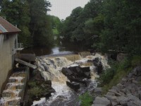
A pretty water cascade along the route in Sweden
Göteburg to Helsingborg August 6 to August 10, 2010 Start 60,871 miles (97,393 km): End 61,083 miles (97,732 km) cumulative
Video Map Teasers
Section 1 Göteburg
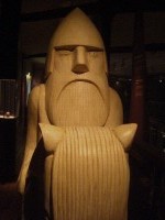
A statue representing one of the Viking gods found at the Göteburg city museum
August 6 to August 8
We chugged along on the slow ferry between Denmark and Sweden on our way to the city of Göteburg (or Gothenberg as it’s known in English). It was a 3 1/2 hour ferry rather than the faster 2 hour one. But we didn’t care. We weren’t in a hurry and besides it was still raining over in Sweden. As it was we arrived just as the rain ended. Göteburg is located a fair distance inland from the actual coast. In this region the coast has a very rocky shoreline. The rocky islands are low lying and often have small houses perched on them. The houses, or more like cottages, are of the board and baton style, usually just a small square structure with steeply sloping roofs. Red seems to be the favorite color. This makes for one very scenic ferry ride up the river. Especially the spot where the boat passes by the old 16th century fortress.
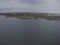
Rocky islands enroute to Göteburg Göteburg at first is rather jarring. The north side of the river holds their port facilities. The city has been a major shipping port since the 1600s and remains so today. So for a long stretch along the northern shore there are huge cranes, large container boats, tons of containers, and all sorts of very active port facilities. It isn’t very scenic, but it’s absolutely necessary. We weren’t sure how easy biking would be in Sweden. It’s not an area you hear of very often on the bike tourists circuit. Although the North Sea route does go through here and it is supposed to be signed. Turns out Göteburg does have a good network of bike routes both as separate paths and shared routes. A very detailed bike map can be obtained from the tourist office for free. Getting to the campground proved to be far easier than we had expected. This would not go on our list of most favorite campgrounds in Europe. As we rode up we saw what appeared to be no more than a large parking lot filled with RVs and trailers. This was not a good sign. It had been raining for most of the day and even the RV sites looked flooded. We soon found out that the tent sites were worse. Stuck behind some of the RV sites was a tiny sliver of land designated for the tenters without cars. Already pitched were 3 very large and one very small tents. The only remaining spots were soggy and muddy. Tents were literally right next to each other. It was awful. So we headed off to another spot where they, for some reason, were not telling tenters about. It was away from the bathrooms located behind the cabins. There was just one tent. So despite being told to camp at the other spot, we stayed here. It was much, much better. During our two night stay we shared this more removed site with just 2 to 3 other tents. Gothenberg is a young city by Europe standards. It was founded in just 1621 specifically to be a trading port. Sweden was late getting in on the China trade business. But when it finally decided to partake they found they needed a good fortified port. They chose the site where Göteburg now stands and then went out and got a bunch of Dutch to build them a city. So if you look at much of the central part of the city today it has a lot of similarities with Dutch towns. The city started originally as a fortified fort with a canal surrounding the walls. There really was a fort in its center. As the city expanded and the fort was no longer needed it was removed and many of the old canals were filled in to become today’s streets. Although the old canal around the former fort walls remains and from that you can get an idea of its original star shaped outline.
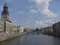
Looking up Göteburg’s canal
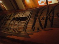
Göteburg was an industrial city specializing in textiles in particular. As the industry grew so did the demand for low to middle income housing. So when the walls were torn down in the 1800s the city rapidly expanded outward. They generally built two types of housing, wood and brick. The wood buildings were 3 to 4 stories tall and were for the poorer classes. Each family was allowed a living room/kitchen. It was sort of a single all purpose room for their bed and such with a small hallway for the kitchen. Subsequent fires that leveled much of the city eventually caused the city to outlaw wood buildings. The middle class got brick buildings. Again they were about 4 to 5 stories tall with 3 sides centered over a courtyard where the outhouses were located. Here a family would get 5 to 7 rooms for the . Many of these old brick buildings still remain and they really make up the character of the city. We walked the 4 km distance from the campground to the center of town to visit the city museum. We wanted to see the remains of Sweden’s only original Viking ship. They’re found spread flat on a large inclined platform in the Viking section of the museum. Looking at these planks as compared to the Medieval ship in Frederikshavn, Denmark we’d be hard pressed to tell the difference.
A few planks of Sweden’s only original ship
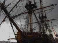
The city museum houses a lot more than just the Viking ship. It has very well arranged displays from the prehistorup to the 1900s. Only when they get to the 20th century does the presentation get rather unfocused. Although they seem to be doing something about that. All in all it is a very good museum. It also happens that the admission ticket is valid for a year and is good for the 5 other city museums. So if you’re visiting for any length of time it’s a very worthwhile investment. We only had time for the one museum, however. So when closing time came we headed out for a stroll along the docks. When we arrived on the ferry we noted a beautiful three masted square sail sailing ship sitting at dock. This lovely sailing vessel is not original. It’s a new copy of the ship Göteburg III which sank just outside the harbor when it struck a well known rock near that 16th century fortress. Foul play has always been suspected but never proven. Following excavations of the original wreck in the early 1990s the idea for building a replica came about.
A modern recreation of the sailing ship Göteburg III
Even though on the outside this looks like an old 17th century boat, on the inside it’s an entirely different story. In order for them to be able to actually sail this ship with a crew and passengers the builders had to meet modern safety, , and Section 2 Göteburg, SE to Helsingborg, SE
The fortress at Varberg August 8 to August 11 When we left Göteburg the day was partly cloudy with a fair amount of sunshine. However this did not stay. As the day wore on the weather got progressively worse until we were riding in a drenching drizzle. It was our first full day of rain where we truly got soaking wet. Unfortunately it seems more and more rain is moving into the region. There’ll be a day or so of good weather then a full day of heavy rain. So it’s definitely a good thing we were headed south. It was easy getting out of the city using that free cycle map. Then once we got into the district of Halland we had a free North Sea cycle route map for that region as well. Plus the route was fairly well signed. So we found we did not need to purchase any additional maps. The North Sea route through Halland will touch the shore and then move inland to roam through the farm fields before returning to the ocean for another short section. Occasionally it’s on separate bike paths but usually it’s on small back roads. At one point when we were wandering through the farm lands in that heavy drizzle we came across a couple men with orange vests directing traffic. They were part of traffic control for the national bike racing for boys age 15 to 16. Pretty soon we saw the entire pack whiz by with a few stragglers bringing up the rear. That’s the one thing about bike racing, if you’re standing out on the course your spectator experience is over in a flash. With the very wet slippery roads we were surprised the bikes weren’t sliding out from under them when they made those sharp turns. Arriving at the campground soaked to the skin we were dismayed to see it looked like a flooded parking lot. The tent sites were positioned along a small strip of grass to one side that at least looked drained. Better still, this campground also rented rooms with bunk beds for just around 100 SEK more. So with shoes squishing here was no question as to where we’d spend the night. After spending most of the night drying out we were ready to move on once again under cloudy skies. At least no rain this particular day. We very quickly passed through the small city of Varberg. From here you could catch ferries back to Denmark. In fact this is where the signed North Sea route in Sweden begins, at the ferry terminal. So from here on we’d just be following a regular coastal Sweden bike route rather than one of the international routes. We passed through 2 small cities, Varberg and Falkenberg. Both towns appear to be fairly new, by European standards. They’re not Medieval. In fact the central cores of the towns look to be from the 1800s.
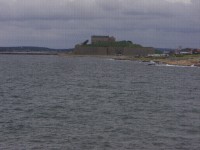
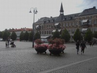
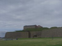
Varberg’s main square Varberg’s biggest claim to fame from earlier times is its fortress. Perched on the coast just to the south of town, this fairly large fortress has quite a commanding view.
A view of the fortress at Varberg
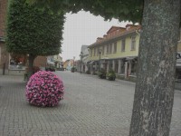
Varberg’s other claim to fame is its surfing beaches. Even though swimmers for the most part have given up for the summer, those surfers were still out in force. In particular those folks engaging in that new parapenting/surfing sport seemed to be out in numbers. They had a great day for it, nice winds and no rain. We cruised into and out of Falkenberg fairly quickly with just a quick ride around town. We wanted to make a good distance this day because the winds weren’t that strong and with the fickle weather we’d been having who knew what the next day would bring.
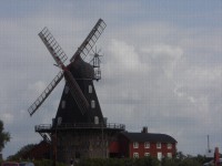
Downtown Falkenburg We’re finding that these towns aren’t as interesting as we’d hoped. In fact, they really look a lot like midsize cities in Minnesota. The buildings seem to be of the same time frame and same style. There were a lot of Swedes who immigrated to Minnesota in the late 1800s, so perhaps they came from this area. We did pass by Sweden’s tallest windmill, or at least their tallest old windmill. They, along with the rest of Europe, are adding a lot of those new 3 bladed white contraptions all over their landscape. So this old windmill probably isn’t the tallest anymore.
Tallest old fashioned windmill in Sweden For our last day riding in Sweden we pushed across 2 peninsulas on our way to the ferry terminal at Helsingborg. The first peninsula we think is actually a terminal moraine from the old continental glaciers. It did involve a 500 ft climb getting over the hill. Then the rest of the morning was spent riding through some pretty forests and then a lot of farm fields. Of course it was sprinkling for some of the way and there was a headwind. The town of Helsingborg is primarily a transportation hub for getting to and from Denmark and Germany. Ferries to Denmark leave every 20 minutes. So it’s real easy to catch a boat at any time you like.
Gate and arch are all that remains of the old fortress at Helsingborg
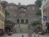
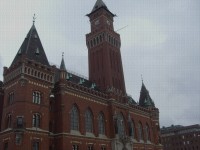
With this in mind we took a quick ride around the very limited old town area. They have a few nice buildings, such as the city hall. Their most impressive structure is the old fortress arch, gate, and tower. But that’s all that remains of the fortress.
City hall at Helsingborg
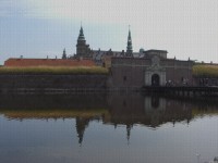
The ferry passes right by the Helsingør fortress called Kronborg. Probably the best views of this fortress are actually from the water which makes the ferry ride more worthwhile. We arrived with the heavy rains and just made it to the campground before getting soaked. So much for Sweden. Now it’s a final tour of east Denmark.
Helsingør’s fortress Kronborg as viewed from the ferry
APPENDIX A – ROUTE Sweden August 8 - Bike paths thru Torp, Krokslätt, Mölndal, askim, Hovas, Billdal, to Lindäs. North Sea route thru Särö, Valida, Kungsbäcka, Fiäras, to Asa. 71.5 km August 9 - Ginstleden bike route thru Frillesas, Väröbacka, Tangaberg, Varberg, Morup, Glommen, to Falkenberg. 74.40 km August 10 - Ginstleden bike route thru Ringsegard, Grimsholmen, Vesslunda, Eftra, Laasand, Ugglarp, Steninge, Särdal, Haverdal, Sanderslätt, Lynga, Villshärad, Frösakull, Tylösand, Halmstad, Fyllinge, Laxvik, Gullbranna, Mellbystrand, Skummeslövsstrand, to Bastad, 92.71 km August 11 - Cykelsporat route thru Grevie, Segelstorpsstrand, Vejbystrand, Ängelholm, Utvälinge, Rögle, Kattarp, Duvestubbe, to Helsingborg. Ferry to Denmark. 83.1 km (97731.5 km)
DENMARK APPENDIX B – CAMPSITES, HOTELS Sweden August 6, 7: Lisebergsbyn Kärralund in Göteborg (275 SEK/night) August 8: Asa Camping in Asa (room 300 SEK/night + 5 SEK/3 minute shower) August 9: Skrea Camping in Falkenberg (260 SEK/night + 2 SEK/2.5 minute shower) August 10: Bastad camping in Bastad (210 SEK/night + 2/3 min shower) DENMARK August 11: Helsingør camping in Helsingør (170 DKR + 5 DKR/shower) REFERENCES Lonely Planet Scandanavia 2010
|
|
Copyright © 1995-2011 by Caryl L. Bergeron - Distribution for personal use permitted. Distribution for other uses with written permission.
Acknowledgements
|