| Caryl and Brian's World Bike Tour |
|
Great Rivers South - 2003 Tour Part VI |
![]()
![]()
![]()
|
|
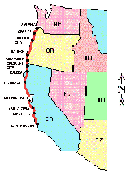
WEST COAST USA - 2003 TOUR PART VI Astoria, OR to Santa Maria, CA September 21 to October 27, 2003 Start 45,195 miles (72,312 km): End 46,442 miles (74,307 km) cumulative
Teasers:
"at this place we had wintered and remained from the 7th. of Decr. 1805 to this day and have lived as well as we had any right to expect", Wm. Clark, March 23, 1806 Captains Meriwether Lewis and William Clark plus their crew of daring men, woman, baby, and dog arrived at the mouth of the Columbia River on or about the 7th of November 1806. It was on this day that Wm. Clark made his now famous declaration, "Great joy in camp". In reality they were more than 20 miles from the actual ocean trapped within the wide and often viciously dangerous bay. It would take them over one month to find a suitable site for their fort and then construct it and move in. It was a long, difficult, uncomfortable month. After arriving at the mouth of the Columbia, the group made their way along the north shore until they came to what is now called Ellice Point. Here they were literally stuck for 6 days on a sliver of land between high tide and the bordering forest. High waves and wind just would not allow them to get beyond this exposed point of land. Everyday brought more and more rain. Everything was wet including their battered and torn shelters. Food was nonexistent. Their clothes were literally rotting off their backs. This was not a place they could stay for long. Eventually they manage to get around point Ellice and onto a sandy beach that was a bit higher above the high tide line. But, lack of game meant that even this was not a good site to remain for long. Meanwhile, Lewis and several men took off to the north along a beach we now call Long Beach looking for a better grounds. It needed to be on high land, have access to plenty of elk, and have a fresh water spring nearby. During their several days' excursions, no suitable site was located. Back at the camp, natives of the Chinooken band arrived to trade and visit. I find Clark's comment on one old lady quite humorous. This old "squar" as he was inclined to call Indian women, along with several young women, set up their camp nearby. She made these women available to the men in exchange for various baubles and trinkets. She was a madam and the young ladies her hookers. A couple months later, after they were settled into Ft. Clatsop, she reappeared with the same set of women for the same purpose. However, this time the captains gave strict orders that no one was to touch them. They'd infected too many of the men with venereal disease which they'd only just managed to get under control. While Lewis was out looking around Long Beach, another group of natives from the southern bank, the Clatsop, came across the bay to trade with the newcomers. Clark could not help but remark on the incredible canoeing ability of these folks. As they paddled across the roiling waves one minute they'd be seen on top of a crest, the next it was as if they'd been swallowed by the sea. He commented that they had to be the best canoers he'd ever seen. Which makes sense as Clatsop children were probably born in a canoe, paddle in hand. The Clatsop suggested that the group come over to the southern side where there was far more elk. This presented the corps with a choice. They could move back upstream to winter with the Nez Perce, people who had already shown their friendliness and an area they already knew well. Or they could take the word of these strangers and move across the river. The question was, were these strangers just trying to get them to move to a closer position to their village, consequently being more available to trade, or were they being quite honest about the elk situation. There were other issues as well. By staying near the coast they might be able to contact one of the many trading vessels that frequented this area. This would give them the opportunity to get more trading merchandize using the letter of credit provided by Jefferson. Or they could perhaps send some of the men back via ship, although most of these men would prefer to retrace their steps through known territory rather than brave the risks of a perilous sea voyage. They could send a copy of their journal back with the ship's captain thus ensuring some record of their accomplishments would be saved. In addition, they could make salt using the nearby sea water. Salt was not only important for improving the taste of their meat, it was also useful in preserving food for the long journey back. They'd left some of their salt back in their buried caches on the east side of the Rockies. So they only needed enough to get back to these. This was a time when the concept of democracy had reached almost a faddish quality in many men's minds. The country was young and this new experiment of allowing the common man to choose his own destiny was all the vogue. So, in the spirit of democracy, the captains took a vote, or at least took the opinions of each member of the party. Everyone partook including Sacagawea and York. All but one, Sgt. Ordway, chose to switch sides and explore. Although Sacagawea said she simply wanted to be anywhere where there was good game and plenty of wapatoes, a potato like root, to eat. The vote taken, they made preparations to move. Getting across the bay was not that simple. No more than a hundred yards out on the water and the captains quickly concluded that their group was nowhere near up to the capabilities of the Clatsops. So the corps returned to shore and retraced their route back up the Columbia to a narrower, less exposed crossing, crossed over, and made their way back west. Once again, they found themselves trapped on the upstream side of a point just east of present day Astoria waiting for the rough waves to subside. While some of the crew sat in their exposed, uncomfortable campsite the hunters and Captain Lewis once again ranged throughout the area. Lewis was searching for a spot for their camp. The hunters searched for those promised game. Day after day they went out and no elk were to be found. Finally, one day after all the hunters except Drewyer, their most capable hunter, had returned to camp, Clark heard the percussion of 5 gun shots. At long last, their wish for elk was answered. Their need for elk cannot be understated as much of their basic needs could provided through these animals. There was the meat for food that could be eaten fresh or jerked and smoked and saved for the trip back upstream. The skins could be tanned using the elk's own brain and used for clothes, containers, moccasins, etc. It was said that each animal came equipped with enough brain material to tan its own hide. Lovely thought. Antlers could be used to make buttons. And the fat could be rendered into tallow that, in turn, could be made into candles, candles that could be eaten in an emergency. The elk was your basic four footed sypermarket. So Drewyer's discovery of a herd of over 200 animals in a nearby field was certainly welcome. The Corps finally managed to move downstream as far as possible and then took a side route up what is today called the Lewis and Clark River to their chosen site. Then construction began. Sketched on the elk skin cover of one of Clark's journal books is a plan for this fort. It was to be a square shaped structure, 50' on a side, with 2 buildings of 15 ft depth opposing each other and a 20 ft wide parade ground in the center. One end was closed by a wooden palisade and double door gate while the other was closed by a palisade and small door. The double door gate was open and guarded during daylight hours only. The small back door allowed 24 hour access to water and other accommodations; i.e. toilet. One building was equally divided into 3 rooms, one for each squad. The other had 4 rooms, one real small for storage, two somewhat larger for the sergeants and Charbeneau family, and finally the largest room was reserved for the captains. Beyond this, nothing is known about the height of the walls, slope of the roof, construction of the fireplaces, location and number of windows, etc. There was never any sketch made of the exterior structure. So most of what is shown at the reconstructed Ft. Clatsop is based on conjecture and information on standard military buildings of that time. Construction started on the 7th of December and everyone got moved in on Christmas day. Life at the camp seemed to settle down to a regular military style routine fairly quickly. Everyone became engrossed in the effort to prepare themselves for the return journey. In particular, new clothing and moccasins needed to be made. The captain's spent the better part of their winter writing in their journals and copying their maps into something more usable. Supposedly they wrote over 1 million words just during their stay at Clatsop. Of course there was constant trading with the Indians the entire time they were there. 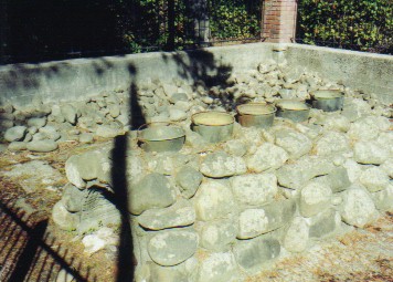
Three men were sent down to the ocean to set up a temporary camp for salt production. They found a site, right in the middle of present day Seaside, Oregon, that had an elk herd and fresh spring nearby. Boiling for salt water consisted of filling 5 "kittles" with sea water, boiling each 6 times until the water was almost gone, adding more water for each boiling cycle. It was finally boiled down to the consistency of a thick slurry. This was taken back to Ft. Clatsop for the final drying, although interpreters at today's fort aren't entirely sure how they finished this last drying to crystals while in a continual rain. They may have tossed it around on a blanket while indoors where it was somewhat dry or perhaps they heated it over a fire. They just don't know. Winters along the Oregon coast are well known for their continual, cold, battering rain. Average rainfall for the months of June, July, and August can be around 3 to 4 inches per month. This number rises to 26 inches for September, October, and November and then up to a soggy high of 33 inches for December, January, and February. In the entire 3 months the corps spent at Clatsop they'd experienced only about 12 days without any rain and only 6 days sunshine. It's no wonder the tone of the journals often seems rather melancholy and the writers rather bored. That doesn't mean there weren't occasions for excitement. In one instance a fellow from another band of Indians hatched a plot to "assanate [McNeal] for his Banket". One of the Clatsop women, partial to this particular man, foiled this plot. But at least for that day the journals ring with lots of commotion. There was also the time when the whale beached down in what is today called Cannon Beach, obviously named for a cannon washed ashore following a shipwreck. The captains determined to get some of the blubber as a supplement to their diet. Sacagawea, the only member of the expedition who had as yet to see the actual ocean, insisted upon going along. She commented that "she had traveled a long way with us to see the great waters, and that now that monstrous fish was also to be seen". After a two day trek they arrived at the site of the whale only to find that the local Kilamox had already pretty much scavenged as much from the carcass as possible. They were busily boiling down the blubber to get the oil and fat. After much haggling, as the Kilamox were very reluctant to give up any of this unexpected gift from nature, the captains managed to get only about 300 lbs. blubber and a "fiew" gallons of oil, every ounce of which they greatly appreciated. "Small as this stock is I prise it highly; and thank providence for directing the whale to us; and think him much more kind to us than he was to jonah, having Sent this Monster to be swallowed by us in Sted of Swallowing of us as jonah's did.", Wm. Clark, January 8, 1806 Originally the captains had planned for an April 1 departure figuring this would get them to the mountains just after the snow had melted. But, as spring grew near, the elk seemed to move inland. So they ended up leaving on March 23rd instead. The fort building and furniture they gave to the friendly Clatsop chief Comowool. They left a note with all the names of the party affixed to the fort's door as well as gave several copies to the natives with the hope they'd turn them over to trading vessels when they showed up. Amazingly one of these letters actually did arrive in Boston after a trip to China in 1807, a year after the corps had returned home. Thus with the words quoted above, Meriwether Lewis, William Clark, and their merry band of 33 set their sights on going home. The structure of Ft. Clatsop gradually fell apart to become little more than rotting logs. Early pioneers recalled seeing the remains of the fort until around 1850 when a fire finally destroyed all that was left. After that, locals tried to keep track of the precise location of the fort's corners using posts and plaques. But eventually all were either lost or moved. Two archeological explorations took place, one in 1947 and the other in the 1950s. Neither successfully pinpointed the exact corners. Even a more recent survey using magnetic resonance to attempt to locate the exact position of the building's corners didn't come up with the answer. It appears that between the previous diggings and the construction needed to put in the current reconstructed fort, they may be lost for good. At least today's building seems to be in about the right spot, if not exact. Of course, we had to visit both Ft. Clatsop and the salt works thus bringing to an end our Lewis and Clark adventure. We continued to read their journals as we headed south to California. After all, we couldn't just leave our heroes out there on the Oregon coast stranded. They were headed home and, in essence, so were we. Homeward bound, the corps seemed a bit more edgy that on the way out. They were continually harassed by petty thievery from the lower Columbia Indians. I guess they had gone downstream so fast in November that the locals didn't get a chance to lift things. On the way upstream with having to constantly portage around rapids they had previously canoed, there were plenty of opportunities for sticky fingers. Many times the captains threatened to shoot anyone who touched their articles. In some cases they even had to beat a few to keep them away. As they approached the dreaded Rocky Mountain barrier, Lewis seems to dip into periods of severe melancholy as he expresses his longing to be home. He used the words, "patience, patience" at the end of one journal entry where he pined away for his sorely missed friends. It was on the homeward journey that the corps had their first fatal encounter with the natives. While exploring the Marias river, Lewis and 3 of his men came across a group of about the same number of Blackfeet. He had hoped to avoid any contact with them whatsoever as their aggressive and violent behavior was well known across the plains. However, it happened that as Lewis came over a rise, he spotted this group who were already pointing at and making gestures toward Drewyer down by the river. He was forced into making his presence known for fear that they'd attack the Drewyer thinking he was alone. From that point things started bad and seemed to just get worse. They sat down to a parley to learn about each other. The Blackfeet proved to be a small hunting party for a much larger group that was about a days ride away. Lewis made the mistake of telling them that they were going to rejoin the rest of their party at the confluence of the Marias and Missouri. They tried to get the Indians to commit to bringing one of their chiefs to a meeting to discuss future relations with the U.S. The Indians made no comment on this. Later that night one of the Fields brothers, who was on guard duty, foolishly left his gun behind his brother who was asleep. One of the Indians grabbed it and ran. Both Fields' pursued the Indian and, when they caught up to him, fatally stabbed the native to get the gun back. Meanwhile, Lewis was awaken to all the commotion. One of the other Indians was going for his gun. He laid chase and when the Indian wouldn't give up the weapon, Lewis shot him with his pistol. Also, meanwhile, another of the Indians was after their horses. He got Lewis' horse, but Lewis got his, a trade that Lewis thought he got the better side of later on. Lewis and his men quickly gathered their belongings and fled the scene leaving behind two dead bodies, one wearing one of those peace medals he'd been handing out all along the way. Knowing that there was a much larger group of Blackfeet nearby and realizing he'd given away the location of the rest of their group, Lewis knew he had to get back to the Missouri as fast as possible. It was entirely likely that the Blackfeet would seek retribution for the death of 2 of their warriors by finding and killing Lewis' entire group. He rode day and night back to the confluence, taking only about 4 hours to get some sleep. Much to his delight he found the rest of his party already in possession of the white perogue and their other cached supplies and ready to move on. They headed on out of the territory immediately. It is rather interesting to note that in all other occasions, the two captains, when together, had been able to bring about some peaceful resolution to all conflicts. This time the encounter ended in violence and death for two Blackfeet an event which would prove to effect US and Blackfoot relations for decades to come. Yet it would seem to me that the Blackfeet must have broken some unwritten code of ethics when they tried to steal the weapons. After all, if you sit down on the same blanket and share a pipe, shouldn't you be able to assume you can sleep without being robbed. "damn you, you have shot me", M. Lewis, Monday August 11th, 1806 On a more humorous note, at least it seems humorous today, Lewis managed to get himself shot. He was out hunting with Peter Cruzatte, a one eyed, nearsighted man who, despite all this, happened to be one of their better hunters. The two men got separated and, one thing led to another, Lewis got shot in the butt. First Lewis yelled to Cruzatte thinking he was the one who shot him. When no answer came, Lewis assumed he was under Indian attack. He hobbled back to the boat and roused all the men in search of the offending natives. None were to be found. Lewis was convinced that Cruzatte was the culprit, yet Cruzatte never admitted to the deed. As Cruzatte had been of exemplary service throughout the mission, both captains were inclined to forgive him. Lewis was lucky. The bullet made a clean entrance and exit, missing critical arteries and bone. However, he did spend the better part of the last segment of the journey lying on his stomach recovering. The Volunteer Corps of Discovery returned to St. Louis on September 23, 1806 to a rousing welcome. Most folks had assumed they were long since dead. Their journey was, and still is, one of the more incredible and successful expeditions ever undertaken by any government. It is one which can never, ever be repeated. It can, however, be relived, somewhat, through a journey such as ours. For 5 months we tried to place ourselves in their shoes, see what they saw, experience what they experienced. We lived their adventure through their journals. "a fine morning we commenced wrighting &c.", Wm. Clark, September 25, 1806 
From Astoria, OR our route headed south along the coast. It'd been 7 years since we'd last ridden Highway 101 from Washington to California. Some things had changed. Traffic seemed much heavier especially with those ever growing in number and size RVs and 5th wheels. The roads seemed somewhat improved, even in California. Some of the towns had grown. Depoe Bay, which we recall as a tiny fishing village from our first visit back in the early 80s, now has a huge time-share condo development just a mile north. Many things were the same. Oregon's roads still were the best for bikers and those hiker/biker sites were still one of the best bargains on the coast. On our previous journey down the coast we tended to ride longer and harder. We'd started in Washington later in the season and had further to go to get to San Diego. This time we decided to go a lot slower and stop at more locations. Basically we determined to try riding simply from hiker/biker spot to hiker/biker site. We specifically chose to stay in campsites we'd skipped before. The Oregon coastal road is quite an engineering marvel. Up until the 1910s communities along the coast were pretty much accessible by boat only. It was in 1917 that the Oregon State Assembly voted to "get Oregon out of the mud" so to speak. Also, the issue of coastal security put pressure on the US congress to fund construction of a coastal road from the Canadian border to Mexico. Major construction of the Oregon section soon commenced. By about the 1930s much of this cliff hanging road was built and even paved in many places. It was a series of unconnected roads with ferries providing the links at the rivers. In many instances these ferry crossings quickly became major bottlenecks in north/south travel. It was then an engineer named Conde B. McCullough (1887-1947) came on board. He'd originally come to Oregon to teach the new bread of college educated engineers at Oregon State University. He was soon drafted into the road department to head up the design of the bridges along the coastal road. McCullough loved to use concrete. All of the shorter span bridges and several of the longer ones use this material almost exclusively. He also liked arches, both above and below the bridge deck. He then combined the structural cleanliness of concrete with design details from Art Deco, Greek, Roman, and Gothic styles resulting in some of the most imaginatively decorative bridge designs ever created. Every part of his bridges seems to have some artistic detail from the concrete handrails with Gothic arches or Doric columns, to the art deco decorations on the overhead concrete rails, to the dentils along the outside of the bridge deck, to the art deco towers greeting the driver at the ends of the bridge. Car drivers just whiz on past these works of art without so much as a second thought. At least on bike, we got to take a much closer look. Unfortunately in McCullough's time, engineers didn't realize that the steel bars embedded within the concrete would rust, swell, and crack the concrete. Consequently, these old bridges were literally crumbling out from underfoot. So in recent years Oregon has undertaken a major project to save and restore as many of these bridges as possible. Not all could be kept. But those that could got new steel rebar, new concrete, new coatings, sometimes complete new handrails, and a new cathodic protection system that, hopefully, will prevent a similar breakdown from happening in the future. The idea is to tie all the rebar together to create a single circuit and then pass an electrical current through the entire bridge. This should prevent the rust from happening in the first place. Fifty years from now it will be interesting to see if this experiment actually worked. We cruised on down Oregon's coast, enjoying every mile along the way. This coast is, perhaps, not quite as spectacular as California's, but it is prettier. It's not as spectacular mainly because often the views are obscured by the heavy tree cover, you can't see the cliffs for the trees. Yet it is these very trees, extending to the ocean's edge, that make it so pretty. Oregon's coastal towns also seem quainter, more "real" than California's. Many of the California towns have become so touristy that they hardly seem to be real working villages anymore. Morro Bay, Monterey, Pismo Beach, Suasalito, for example, are so filled with tourist trinket shops, hotels, and restaurants you begin to wonder if anyone actually lives there permanently. Oregon's towns, even those that are touristy, still seem to work. Of all the sections of the Oregon coast, north, middle, and south, the southern section is probably our favorite. It doesn't seem as wet as further north, which may just be because we got lucky. The scenery is prettier than up north, traffic a little bit lighter, and the people friendlier. We kept meeting folks who gave us some great little gems for quotes. One fellow in Bandon exclaims, "I'm on a seafood diet. When I see food, I eat." Sounds like a bike tourist type diet. A fellow in Brookings referred to the tows as a "place where the women can't get pregnant and the men look like they are." Brooking has over 50% retired residents. It's a humorous view of oneself. 
Of all the towns, we think Bandon was our favorite. Granted it has become a bit of a tourist mecca. But, at this point it hasn't grown too many major resort hotels and the trinket shops seem to be relegated to the town's original, older buildings. Oh and some of those houses. WOW. Perched on the edge of the cliffs overlooking the bay, ocean, and lighthouse, they have amazing views. We passed house after house thinking, "hmmm, I could go for this." Ah, despite the temptation we still have no desire to own property again. There's something about entering California that tends to put us on edge. The first time there was something about the traffic in Crescent City that just set us to teeth grinding. Maybe it was just a bad encounter with an aggressive driver or just too much speed. Anyway, we pushed through town stopping only long enough to buy groceries and immediately headed on to the next hiker/biker campsite. Our first impression of Crescent wasn't too great. This time we discovered that the hiker/biker campsite we were headed to was closed for the season. Having the choice of riding an additional 35 miles or or stopping early, we chose to stay in town for the night. The campground wasn't all that great, although the bathrooms were spotless and the showers nice and hot. What absolutely took us by surprise was the fact that within a time frame of less than an hour while we wandered around town we were accosted for money twice. Here we've traveled all across the country for almost 7 months straight, walked or ridden all over various towns, yet this was the first time anyone had asked for money. Even in Missoula, Bozeman, and Butte, three cities that have inherited a major homeless problem, we were never bothered. California's homeless problem has grown to monumental proportions. California is also where theft has been a problem, for us at least. On our first journey through some kids tried to steal our bikes from an RV park in Mikinleyville. We got lucky. I woke up. This time while shopping in a K-Mart in Santa Cruz someone made off with our two little solar panel AA batter rechargers. We were pissed, really pissed. But, looking back on it, the solar panels were damaged in a heavy rain in Uruguay and didn't work all that well anymore. The missing batteries were old, abused, cheap, and also didn't work very well. Later we found a $20 map book for N. California left behind at a hiker/biker site, a book that will be useful for our 2004 hiking journey. On a hiking trail we found a fairly new pair of Foster Grant sunglasses, probably also worth $20. And a liquor distributor have us 2 half bottles of a very good Chardonnay wine, an $11 value. So the way we figure, everything came out even in the end. Still, we traveled all across the country, left those panels on the backs of the bike for all to see numerous times and they wind up being lifted in California. From Crescent City to Leggett, Rt. 101 heads through the wonderous redwood forests. Walking among these towing giants, the world's tallest trees, is almost a magical experience. Simply put, they are magnificent. We've driven and ridden through these trees several times. Yet there is so much more to see. There are over 100 miles of hiking trails and several rougher dirt roads leading off into more wild back areas. We met one fellow, the owner of the old WV bus style van, who was spending several weeks backpacking back and forth across the park. How wonderful to spend your nights out among those quiet trees, just you and those trees. We concluded right there and then we just have to return with the camper sometime to spend much more time hiking. Perhaps next year. We had a rather strange happening at Standish Hickey and Ft Bragg. Normally we find the hiker/biker sites are not especially crowded during the month of October. There may be us and one or two other campers. Yet for some reason a huge group of 10 to 12 managed to collect at these two sites. Ft. Bragg was really bizarre in that our first night there we were part of a group of 12. The next night there was just us. It wasn't even a single group of 9 others. There was one group of 3, another of 4, and several singles. For some reason we had all managed to collect at the same sites. It was rather strange to be amongst so many bikers and, really, too crowded. We decided to stay an extra night at Ft. Bragg, thus giving the others a one day head start. After this we only encountered larger groups in Monterey and Pismo Beach. I don't recall seeing so many bikers in the month of October back 7 years ago. Biking the coast must have grown even more popular in these intervening years. After passing over the mountains from Leggett back to the coast, you leave most of the lush, dense northwestern forests behind. The hills along the coastline become drier and more open. This affords spectacular vistas from every point and spit of land. But, shade becomes much less common and the hills very brown, at least in late fall. Granted there are patches of lush forests extending all the way to Lime Kiln State Park south of Carmel. Even a few groves of redwoods extend this far. But if you're looking for extensive forests, the coastline is not the place to be. With the clear air and cloudless skies, the ocean does take on a deep, beautiful aquamarine color that more than compensates for the dusty, brown looking hills. It is surprising just how remote the northern California coast really is. Between Eureka and San Francisco, there is basically one large town, Ft Bragg. The rest are just small towns having correspondingly small grocery stores. Prices in these stores seem to get higher and higher the closer you get to San Francisco. Point Reyes Station's grocery prices are so high it's laughable. Fortunately we'd brought enough to get us beyond San Francisco to Pacifica where large groceries can be found. There's a lot of marine life along the California coast. Birds abound everywhere you look. There's everything from the huge pelicans that float like big buoys atop the waves to the funny long legged birds that run up and down the beach after each wave passes in search of whatever is left behind. Of course there is always the ubiquitous sea gull willing and eager to share your lunch. Crows and other flying critters will descend upon any vacated table to quickly clean up any leftover scraps. It's only a matter of minutes before this clean-up crew shows up after you vacate a table. Some birds are migratory. Many stay year-round. The west coast in general must be a paradise for bird watchers of all types. As you travel along the coast you can catch sight of all sorts of marine mammals as well. Sea lions seem to have taken over Monterey Bay to the point that a bunch decided to haul out on one of the sail boats moored nearby. A photo of this strange phenomena appeared on the front page of the local newspaper. Imagine wanting to go out for a sail and finding a dozen or more of these huge animals sitting on your deck. Uninvited guests. Want to bet getting them off is just about impossible and harassing them to accomplish that is probably illegal. Just north of the Hearst Castle State Park is series of wide, sandy beaches that have become favorite haul-out spots for the elephant seal. Years ago when we did our first ride along this coast the seal had not yet returned. Six years ago when we rode this route a second time, there were about 1500. In 2002 there were 2500 pups born and they are now expecting over 3500 males, females, and juveniles to appear for the mating season this December. Having been hunted nearly to extinction these remarkable, somewhat rather ugly in the case of the male, animals have made a fabulous recovery. Even the viewing locations for these seals has evolved. It started as nothing more than a small parking lot. This little lot has grown, big time. Now a brand new raised walkway is being added in an effort to keep people off the sand and away from the often aggressive seals. Docents for the Friends of the Elephant Seal organization are always on duty during the molting and mating seasons to answer questions and to keep people at a distance. We had to wonder if next there may be a hot-dog stand, gift shop, and parking fees. Hopefully not as it currently makes for a nice, free treat for traveling families. We plowed on southward knowing that the winter foul weather was hot on our tails. The newspaper showed rain in Washington, then Oregon, then Crescent City. We were just keeping ahead. Cold, wet rainy days on the coast can be just plain miserable for riding. So we were anxious to avoid the bad weather. We hustled on past San Francisco. Having visited this city on numerous occasions we felt no particular inclination to visit once again. But, perhaps we would have been better off had we stopped. California State Parks had two nasty surprises in store for us. We passed through San Francisco on Friday afternoon thinking we'd take a hotel in Pacifica a bit further south. We had coupons for prices ranging around $55 to $60. However, it turns out these coupons were not valid during special events and it just so happened Half Moon Bay was having their annual Pumpkin Festival. We'd missed the comment on our maps that noted this festival happens the first weekend every October. Evidently it's quite a big deal. We're talking thousands of people descending on this little coastal village causing bumper to bumper traffic for miles and miles. All along the road fields are filled with those orange/yellow gourds for sale along with inflatable jumping cages shaped like castles, wagons providing hay rides, hay bale mazes, and all sorts of other attractions intended to keep the tikes busy. Consequently hotels were full or, at least, way above that $50 number we'd been looking for. "Fine," we thought, "We'll just go on to the half Moon Bay State Park for their hiker/biker camp site. No way. It turns out it was closed due to a major renovation project. Our choices weren't looking good. We could try to find some place tucked in the bushes to camp for the night, not a great option. Or we could wait until about 6 PM when the manager of a little hotel on the beach in Pacifica would know if he had any no shows. We waited. He seemed fairly confident that there would be at least some place to put us. I guess no shows happen a lot. However, we were rather nervous the entire wait. We got lucky. He had a room. It wasn't cheap. But it was on the ocean side with a great view of the oncoming surf. So I suppose it was worthwhile. Now, we had planned to ride just the 15 miles to Half Moon Bay and take a must needed day off. Since the campground was closed that idea was scuttled. Our next plan was to ride on to Santa Cruz and the New Brighton State Park and take that day off there. It was a fairly easy ride to Santa Cruz, only one or two hills of any consequence. So we arrived fairly early. We went for a bite to eat, shopped for groceries, and basically took our time before heading over to the campground. Our mileage was over 70 at this point and we were in no mood for riding any further. Add this to the fact that this was the day those little solar panels were snitched. We were justifiably pissed. We had about an hour or so before dark when we headed over to the campground. Much to our shock we discovered that New Brighton was also closed. Signs on the front gate seemed to indicate it was closed permanently. However, on the internet the site says it's also being rebuilt. No matter the cause, we were stuck. The next campground was over 15 miles further. At this point we were joined by another biker. This fellow was just finishing his first day out on his second ever bike tour. He'd had a great day and was in a great mood. So when he kept whooping on the downhills and laughing at the oncoming dark and our present situation, we were not amused. We were having a bad day. We pushed on. Our companion suggested that we stop at Manresa State Park Campground. He'd heard somewhere that state law required a state park to take in bikers if they arrive at dusk no matter whether they were full. Not so. After a 2 mile detour we were turned away to ride, in the dark as our headlights weren't working, to the next campground about 3 to 4 miles further. We arrived after dark having ridden a full 95 miles on the day we'd planned to ride just 15. Grrrrr. We were not happy with California at that point. Fortunately things got easier, or at least the rest of the campgrounds we were aiming for were open. Monterey's Veterans Memorial Campground is located high up a steep, steep hill just 1 mile south of the downtown. Unfortunately due to its easy accessible location, it has become a major staying place for many transients who infest the entire California coast. We decided it wasn't worth putting up with the hoard of these folks staying in the hiker/biker site when paying for an individual site was not that much more expensive. Nighttime in this park is not a quiet affair. There's a continual honking of the navigation buoy out in the bay as well as the barking of seals hauled out on the rocks. Those seals are amazingly loud. In the morning, the nearby Naval officer's training school holds an early morning reveille and formation which always involves yelling. You'd better be an early riser if you want to stay here. Now comes the best part of the coast. From Carmel to Hearst Castle is that famous Route 1 road that hugs the edge of the cliffs plunging into the ocean. This time we found the hill climbing to be far easier than we remembered. I guess after all the super difficult bike packing we've done in the intervening years, we've become accustomed to far harder riding. Of course the views are wonderful and that clear, blue/green water just makes the entire scene picture perfect. We stopped at Big Sur State Park, probably one of the most popular campgrounds in the entire state, and in Lime Kiln SP, a spot we'd never taken the time to visit before. From there we finished the hills, and rolled onto the flatlands around San Simeon. This was our finishing ride. The final couple days felt more perfunctory than anything. Our objective was to get to Santa Maria on October 27, the day our storage lease on the camper ran out. We had time to spare. So we stopped for a night at Morro Bay, an interesting campground bordered by a golf course, and spent a day off in Pismo Beach. It was in Pismo Beach that we got the startling news of the California fires. It seemed that our curse with fires was still in effect. Huge fires raged from Los Angeles on south. Most surprising was the fact that one of these fires was burning down the neighborhood we used to live in, Scripps Ranch. Later we were to learn that the houses burned literally surrounded our old house on all sides. That house miraculously was one of the few to survive. We wonder if the priest who now owns it might have had some divine intervention. Anyway, we still have a soft spot in our hearts for that house and were delighted to hear it still stood. Although, for the rest of the neighborhood we grieve. And so we finished. We left everything in the Oceano campground, took the short ride up to Santa Maria, uncovered the camper, and officially closed our 2003 Lewis and Clark expedition. "we were met by all the village and received a harty welcom from it's inhabitants", Wm. Clark, September 23, 1806 Appendix A - RouteOregon September 21 - 28.41 miles ACA Route Warrenton to Seaside California October 5 - 32.97 miles ACA Pacific Coast Route to Crescent City
Appendix B - Campsites or hotelsOregon September 21 - Circle Creek RV Park ($16.20) California October 5 - Shoreline RV Park ($14) |
|
Copyright © 1995-2011 by Caryl L. Bergeron - Distribution for personal use permitted. Distribution for other uses with written permission.
Acknowledgements
|