| Caryl and Brian's World Bike Tour |
|
Great Rivers South - 2003 Tour Part V |
![]()
![]()
![]()
![]()
|
|
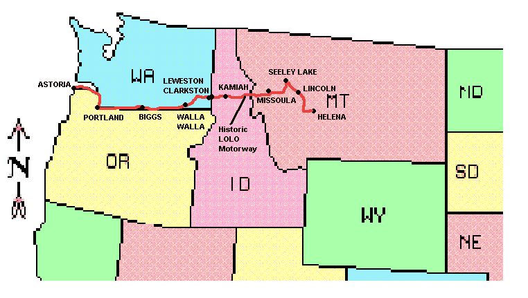
LEWIS AND CLARK ROUTE 4 - 2003 TOUR PART V Helena, MT to Astoria, OR August 18 to September 20, 2003 Start 44,090 miles (71,112 km): End 45,195 miles (72,312 km) cumulative
Teasers:
"proceeded on up the Travelers rest Creek accompanied by the flat head Indian" Wm. Clark, September 11, 1805
So the 50th anniversary event has come and gone. In August Caryl's parents celebrated 50 years of marriage with a big family get together. The actual event turned out just fine. It was the drive to and from that was an ordeal. The party was held on Mackinac Island in Michigan. This is a tiny 3 mile long island located right at the confluence of Lakes Michigan, Superior and Huron. It's claim to fame is that, supposedly, it doesn't allow any motorized vehicles. Although, while there we did spot a large dump truck, an SUV being transferred on island, and large dumpsters that required a semi for transport. Anyway, for us to get there and back necessitated renting a car for 10 days and driving the 1500 plus miles, 3 days, each way. It was fun to be there, but it was definitely a relief to have that long drive over. In the 10 days we were away from Helena and the Rocky Mountains, things had changed. Fires had erupted all over Montana including around Helena. Smoke hung heavy over the city almost like a dense fog. Everything smelled like one gigantic campfire. It would be nice to get away from the smoke somewhere, but with all the different fire complexes throughout the western part of Montana, we doubted we'd be seeing much clear air for quite a while. Fires are a rather interesting and controversial subject in Montana. The year 2003 was shaping up to be just as bad a year as the year 2000. By mid August over $23 million had been spent on fire suppression and that number was continuing to grow. One of the major reasons the fires were so many and so intense was because there is a significant amount of live and dead undergrowth. One plan submitted by the Bush administration called for clearing the undergrowth as well as thinning the old trees thus removing some of that extra fuel. This, of course, was opposed by environmentalists who reasoned that only natural fires should be used to clear undergrowth. So the undergrowth gets worse and worse and the fire seasons get worse and worse. However, based on the complaints on the front pages of the newspapers, it's likely that some some sort of forest management plan will be adopted. The only question is how much more of the forest will burn before this happens.
Each fire "complex" actually is made up of a bunch of fires in one particular area. I suppose a particular complex is probably placed under one management team to keep things as organized as possible. Each complex has a name, the Lincoln Complex for example, and each fire is given a name, Talon, Wasson, Moose, etc. I think the name comes from the start location for each fire. Sometimes fires merge in which case the names are joined, Moose-Wasson fire. It can really get complicated when four or more fires join. Tracking where fires are, where fighters have established fire lines, where roads and forests are closed, where homes have been evacuated, and everything else really does take concentration. Fire managers do have their work cut out for them. Local interest rises dramatically near each fire complex. Daily updates are presented with fire managers, sheriffs, and priests each giving some sort of speech, or sermon as the case may be. And, of course, entrepreneurs hit the scene with T-shirts for sale for each different fire. I guess having a "I survived the Moose-Wasson fire" T-shirt could be a real status symbol among the fire fighter gang. Yes they're dangerous, they're tragic, they can destroy houses and even kill. But these western wildfires do have a way of creating a sense of community that is hard to find elsewhere. "The road through this hilley Countrey is verry bad passing over hills & thro' Steep hollows, over falling timber &c. &c. continued on & passed Some most intolerable road on the Sides of the Steep Stoney mountains, which might be avoided by keeping up the Creek which is thickly covered with under groth & falling timber", Wm. Clark, September 12, 1805 Out of Helena we decided to continue on the GDMBR, going south to north or backward to the usual direction, for as far as possible or until we got to Seeley Lake, which ever came first. Fire danger already had some of the forests closed and new closures could happen at any time. In recent press releases the Forest Service was using the strongest language possible to discourage people from recreating in the forests. Simply put, they didn't want to have to be concerned about finding and evacuating people should a new lightning strike start another fire. One Forest Service employee told us of two strikes that happened near the Gates of the Rockies both of which had reached 5 acres in the 40 minutes it took to get helicopters out to drop water on them. Fires grew fast and furious every time there was another lightning storm. So we go our hands on a weather report. No rain, not even a sprinkle, was predicted. So what the heck, we went for it. We headed up over MacDonald Pass using the paved Rt 12 so we could get water at the campground at the top. Priest Pass had been dry as a bone 3 years earlier and with 3 more years drought would not be likely to have any water this year. We turned right onto Dog Creek road, the creek surprising us with its fairly strong flow of water, and made our way into the forest. That night we camped at the fascinating Bald Butte Mine complex and it rained. Once again the true weather and the prediction did not match. I lay on my mattress all night counting the seconds between a lightning flash and the resulting thunder. Fortunately, in never was less than 14 seconds which indicated the storm center was far, far away. Ya takes your chances in fire season in Montana. We were climbing on steep, rough backcountry roads through some of the most delightful scenery God had the inclination to lay down on our planet. Rugged hills covered with deep green lodgepole pines surrounded our route up to the Continental Divide crossing. Crystal clear brooks tumbled and babbled down the steep inclines well below the level of our road. When Lewis and Clark climbed over these difficult mountains they had nothing to follow but what they called Indian "roads" which were not much more than trails. In some cases they simply had to make their own trail. The trails were often so steep even the horses tumbled on many occasions. Looking at the rocky, loose terrain I could only imagine how difficult their crossing must have been. Today we have roads. They're steep and somewhat rocky. But, thank goodness, they are there. Fires plagued Montana and, in particular, the Lincoln area. As we descended from the tops of the mountain ridges we were greeted with a thick wall of smoke. Lincoln was quite literally smothered in smoke. Two fire complexes bordered the town, one smaller one to the southwest and one very large complex to the northeast. By the time we arrived, the larger fire had reached over 29,000 acres and was still growing daily. The entire town was on evacuation alert and over 150 residents were already evacuated from their outlying houses. Heavily attended meetings were held every evening in the town park where residents got the latest updates. Both fires threatened the town and threatened to cross the highway 200. For us, the main effect was the inability to continue on the GDMBR between Lincoln and Ovando, the roads were closed. Other than that and the choking smoke, we were not effected. Hawgs ruled the road. This year was the 100th anniversary of the Harley Davison motorcycle manufacturing company. From modest beginnings building essentially motorized bicycles, the company grew to create the epitome of motorcycles. It seems others may build motorcycles of all sizes, horsepowers, and comfort levels, but the Harley always stands out as the (I cringe to use the term) biker's bike. To celebrate this 100th year anniversary, hundreds of thousands of Harley riders were journeying from all across the continent, and probably from Europe as well, to congregate upon the city of their origin, Milwaukee. It just so happened that the day we left Lincoln was the day this motorcycle caravan descended upon this tiny town to quite literally inundate it. We ventured out of the campground a bit later than normal, as we'd decided to take advantage of the local restaurant for a good, cooked breakfast. At breakfast we'd seen only a few cycles. By the time we'd packed up and pedaled off there were literally thousands around, probably more than there were mosquitoes. They came in all shapes, sizes, colors, and decorations, both the bikes and the drivers. Some were a real comfy style, bigger than some cars, with a trailer in tow. Some looked like something you'd imagine in a Hell's Angles gang. Some were antique, most were new and modern. One was decorated in dead animal skins, we're not entirely sure why. Another had paintings of naked women on the front fender, this drew a lot of attention from the men. The riders were all clad in lots of leather, mostly black, often fringed, usually sporting the Harley winged logo across the back. Tattoos were the skin decor of choice positioned in virtually any location where body might have it exposed and even some places it wasn't. There were young, middle aged, and old all congregating at this one spot. Even as we rode west we continued to pass hundreds and hundreds more, all bound for Milwaukee one way or another. Pedaling up to the gas station on our little human powered bikes with our super light weight helmets, well worn gear, and lightweight clothes, we felt entirely out of place. Now just a week earlier, bicycles had ruled the road during the annual Double Divide Ride. It starts in Helena, goes over the divide once at MacDonald pass, then north through Lincoln, over the divide a second time, and back to Helena. It's a two day ride on all pavement, not the rugged dirt route we'd been on. They spent the night in Lincoln. We'd been seeing words and messages painted on the road giving directions such as "Turn right here, that means you Melissa", "Come fly with me" and "brakes are for kids" as you zoom down from MacDonald pass, "DDR showers" at a spring at the pass, and "DDR breakfast" in Lincoln. If only we'd been a few days earlier we might have fit in much better with the passing crowds. As it was, we hurried to get our gas and got out of town. Although we give the motorcycle drivers some credit, they usually did wave in passing giving us some support We choked and gagged our way along St. Hwy 200 between Lincoln and Ovando. It's a nice relatively flat highway, busy but with a sizable shoulder. It winds along some spectacular mountainous scenery that at this time was completely obscured by smoke. In Lincoln we could barely see beyond 100 yards, hardly more than a rural block. In Ovando, visibility had grown somewhat. At least we could see hints of the outlines of mountains along our route. The Missoula newspapers were warning of extremely unhealthy air quality and recommending avoiding outside activity. And here we were riding bikes along the highway. Yes we are a little crazy at times.We took a break in Ovando to try clear the lungs a little and to grab lunch. Ovando brought back some fond memories of the GDMBR. It was here we bought a half gallon of ice cream and, much to the surprise of the lady at the store, polished it off in a matter of minutes. There's one thing you can say about the GDMBR, it's a definite calorie burner. This day we were greeted by the town mayor, Skip. We knew that because he has a Montana shaped pin on his hat that says, "Skip, Ovando Mayor." He is a learning challenged young man that the town seems to have taken under its wing. His house is a rather decrepit looking shack located across from the Ovando Museum. He holds down a variety of jobs including mayor, wood chopping, and caring for some animals. He's a real lady's man, getting a hug and kiss from all the local women who he calls his "girlfriends". He seems to be the official town greeter as well. I'd be willing to bet almost every bike tourist passing through winds up having a conversation with Skip. This day he was filling buckets of water in order to run a load of laundry in a couple of old fashioned washing machines, dating from the 1930s. He called them his laundromat. We just happened to provide a little extra afternoon entertainment for him. From Ovando to Seeley Lake is one of the easiest sections of the GDMBR and one of the prettiest. You climb over a 1000 ft. hill, not even a pass, along a well improved gravel road with a good solid surface and not overly difficult slope. Along the way you pass among some of the older lodgepole pines having big, 5 ft. diameter trunks. Undergrowth in this moist region is quite dense. At the top of the hill you pass alongside a lovely mountain lake nestled between two high mountains. On a clear day you'd see reflections of the surrounding mountains in the calm waters of this sheltered lake. Unfortunately, we were still dealing with dense smoky air which meant we could hardly see much beyond the water's edge. We join the Montanans in wishing this fire season would soon come to an end. We'd begun to wonder when we'd spot our first bear. Spend much time out in the forests of Montana and Idaho and you're bound to spot a bear or two or three. Now we're not ones to go out of our way just to have a bear encounter. In fact, we're perfectly happy to have them way out in the wilds, far far away from where we happen to be, especially when we're cooking dinners and sleeping out in the boonies. But, bear encounters just seem bound to happen and this day was it As we rode up to the Monture Campground just north of Ovando, a small horse camp that at this time was deserted except for a couple of horse riders out in the wilds. Brian, as usual, was in the lead while I trailed a couple hundred feet behind. Suddenly he came to a screeching halt and waved to me to stop. Bears, we'd heard, can tend to have a chase instinct like a dog. So whenever we spot one from the bikes we try to get stopped and off as quickly as possible. Looking off to my right I caught a glimpse of the critter giving Brian such a start. This little bear had a lighter brown fur, much lighter than the usual dark black of typical black bears, and a patch of white under its chin. Clearly it was just as, if not more, startled as we and just as anxious to get outta there. I saw it make a fast swivel 180 degrees and run right into a downed tree. After a few seconds trying to figure out a way around, under, or over it, it bounded to the side and disappeared into the brush. Needless to say that night we were extra careful to get our food hung 10 ft up, 4 ft out, and 4 ft down. Our next bear encounter, 2 days later, would be not quite so heart-stopping nor quite so close. We sat in a quiet Forest Service campground and watched a little, all black bear play around on a fallen tree well away on the other side of a fast flowing river. It was one of the few opportunities we'd ever had to watch a bear in the wild for a long period from a place of relative safety. Now that was our kind of bear encounter. After finishing map 1, section B of the GDMBR backward from Polaris to Seeley Lake, we returned once more to the pavement to make our way into the hometown of Adventure Cycling Association, Missoula, in order to prepare for our final leg of the Lewis and Clark Trail. Back in that cold September of 1805 when the expedition was still making its way west, they passed just south of what is now Missoula. After trading for horses with the Lemhi Shoshoni, they hired an old man they named Old Toby and his son as guides to take them over to the Nez Perce on the west side of the Mountains. Toby seemed to be the one person among the Lemhi who knew the route. They first ascended to what is now Lost Trail pass where, for some unknown reason, Toby seemed to lose the trail for a couple of days. Finally they made their way down into what is now known as the Bitterroot valley where they were greeted, wined, and dined by the Selish, relatives and trading partners with the Nez Perce. The corps traded for more horses to replace those that had rolled down the hill while climbing over Lost Trail Pass. They proceeded onto the base of the trail over the last stretch of mountains, now known as the Lolo Trail, and took a rest at a place they named Travelers' Rest. It was while they were in the Bitterroot Valley that Old Toby made what must have been one of the most startling revelations the corps heard over their entire journey. It was one of those statements that would cause a person to bang the heel of their palm on their forehead and decry "If I'd only known!" He told them that if they were to continue up the Bitterroot River and take a right over a fairly easy pass they'd find themselves right back at the top of the Great Falls. It was a journey that would take only four days. They had just spent 2 months going way, way south to cross over Lemhi Pass and then return back north. Those 2 months may have been just what they needed to get to the Pacific and then back across the mountains before winter set in. But, now that time was lost for good and they were looking at having to spend winter in the west. Meriwether Lewis did take advantage of this little short-cut on the way back, however. While Clark's group headed back over the Lemhi to retrieve the canoes and gear they'd stashed at the base of the pass, Lewis and company took the short cut over to the Missouri and then proceeded on up the Marias for further explorations. "I have been wet and as cold in every part as I ever was in my life, indeed I was at one time fearfull my feet would freeze in the thin Mockirsons which I wore", Wm. Clark, September 15, 1805 "Fraziers horse fell from this road in the evening, and roled with his load near a hundred yards into the Creek. we all expected that the horse was killed but to our astonishment when the load was taken off him he arose to his feet & appeared to be but little injured, in 20 minutes he proceeded on with his load" When Lewis and Clark left Traveler's Rest near Lolo to head west they were expecting to have a hike of about 5 days to get them to the other side. It was mid September and the snow was coming earlier than normal. They'd been told there would be little, if any, game along the trail and even the natives often faced starvation when trying to cross. They knew they needed to get across as quickly as possible. What they encountered was the most rugged and difficult terrain they'd encountered thus far. Rather than 5 days, it took them a total of 11. They ran out of food and suffered incredible cold and snow. They resorted to killing and eating one of their colts and another stray they found. Finally, two days from the end, Clark went on ahead with some hunters to try to find food to bring back. He came across the Nez Perce near the present town of Weipe. The Nez Perce gave them food and clothes and, basically, saved their lives. To the Nez Perce, the ragtag band of Clark's forward hunting party presented quite a dilemma. Being a group of heavily armed men, Sakajawea was back with the main group, they appeared to be a war party. Yet from their ragged appearance and, especially, the fact they did not have any blankets made it appear they had been in a recent confrontation and had lost. Nez Perce had a custom that a man who performed some extraordinary deed or had killed would paint their face black. Naturally they assumed York, a member of the advance party, had done something quite outstanding. Further discussions, after the strangers were fed and housed, revealed that they were just visitors, passing through. So here was a group of very weak strangers, most of whom became quite sick after eating all the salmon and camas roots the Nez Perce had given them, carrying a great many marvelous things they could make good use of. Many men simply wanted to kill the men and keep the goods. Fortunately there happened to be an old woman who'd been captured by the Blackfeet and sold to Canadian white men. The Canadian's had treated this woman very well, so she urged the men to do the strangers no harm. Nez Perce elders held a council and, after some debate, voted to make and retain peaceful relations with the white men. This was a policy they were able to keep for 70 years, until the future President James Garfield insisted the Nez Perce be removed from the Bitterroot valley and the Nez Perce Indian wars began. Had the Nez Perce known that the Corps of Discovery really was scouting land to come under the jurisdiction of the U.S. and how much this would effect them, one has to wonder if they might have followed their first instinct. "after smoking the pipe and contemplating this scene sufficient to have damp[ened] the sperits of any except such hardy travellers as we have become we continued our march", M. Lewis, Friday June 27th, 1806, returning along the Lolo Trail After spending a few days in Missoula picking up supplies, stopping in at ACA headquarters, and generally taking a rest, we headed on south to the little town of Lolo and then on up the pass. We stuck to the pavement all the way to the pass and beyond. Rt. 12 climbs gradually up to the crest of the mountains and then descends to follow along the river for miles upon miles. It's an easy road to ride, but would have been a very difficult road to build. It's etched into the cliffs that edge the river for much of its distance. Essentially paralleling Rt. 12 is the older Lolo motorway. This road follows the original trail used by the natives and Lewis and Clark to cross the pass. Rather than following the river, it stays high along the crest line climbing up and over knob after knob after knob. Due to more fires, about half of this old motorway was closed to all unauthorized traffic. We were able to climb up the 2000 feet to join this motorway at FR 107, about 50 miles into the trail. Oh well, we couldn't do all the bikepacking, but we did get to do quite a lot. 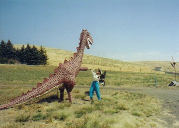
The Lolo motorway is not an easy road. It follows along that ridge line over each and every knob that the Corps of Discovery had to surmount. Each little blip on the elevation profile represents a stiff, stiff 400 to 500 ft climb over a difficult rocky road. These little blips get your thighs burning, knees aching. Big climbs seem to be nearly impossible vertical walls. It takes many rests to get over each 1000 ft climb. It's absolutely a spectacular ride with incredible campsites all along its length. But I do have to say, we were really, really tired by the time we reached the end at the town of Kamiah. Once down from those rugged mountains Lewis and Clark, as well as ourselves, encountered a very unexpected geological feature. We have to remember that folks back in the east in the 1800s expected the continent to present a very gradual climb to an easy-to-cross single set of mountains before heading down to the ocean. Instead they found high, rugged mountains and then this arid, almost desert like region before another set of rugged mountains. As they passed the area around today's towns of Lewiston and Clarkston they remark that there was not a stick of timber to be seen. Being late September, the hills would have been covered in brown, crispy grass presenting the appearance of a dry, dry desert. For us bikers, riding across this region is much to much like riding across the plains of eastern Montana. As usual, the second week in September was hot, hot, hot. Record temperatures exceeded 95 to 98 degrees day after day. Once again we found ourselves trying to ride early and then quit before it got too miserable. From Kamiah you could head along Rt. 12 which stays in the Clearwater river valley. It would be an easy, flat 50 miles with one slight problem. Rt. 12 in this area is narrow, has no shoulders, and has tons of traffic. ACA doesn't recommend going that way. Idaho state patrol doesn't recommend this route. Even the Idaho department of transportation doesn't recommend it. So, for safety's sake, we chose to ride across the prairie rather than take the river route. Unfortunately, leaving the river always entails a steep climb out of its deep valley up to dry, open prairie toplands. Once you climb that 2000 plus feet you find roads that roll up and down over this endlessly undulating country. Every little creek has etched a deep ravine upon this landscape. Shade is hard to find. After 5 days riding over the super tough Lolo trail, the additional 2 days over this undulating and hot, dry country was enough. Time for a rest. Want to know how Caryl handles a flat tire. She yells, screams, throws her packs, and hollers a few words that would blister anyone's ears. Bags, helmets, gear flew everywhere. OK let's be fair. She'd had 3 flat tires on the Lolo trail, 2 in one day, and on the final day ride down to Kamiah she had another 3, all in one day and two right in a row. When you're dead tired, hungry for a good lunch, the last thing you want when you're only 5 miles from town are 2 more flat tires. Fortunately Brian did not have access to a video camera or she might have thrown that as well. Yet, Caryl's plague of flat tires was not to end. In 2 days while taking a rest in Lewiston she had no less than 3 more flats. Along the bike path, normally a nice feature but perhaps a bit of a curse in September, there is this weed that grows nasty seeds people give the apt nickname of goatheads. They must be all over this path and each one imbedded itself into Caryl's back tire. Even after leaving Lewiston she had another flat in the town of Pomeroy. That made 9 flat tires in about as many days, a record for us. Ah, finally Brian had a flat. Actually not just one flat but four. Just when it was beginning to seem that the only tire to ever get flats was that purple bike's rear wheel, the blue bike finally joined the fray. He started with one flat in the front. That fixed, it promptly went flat again. Evidently the thorn had gone in one side and continued on to puncture the other side. Then came not one, but two encounters with wires from the plethora of bits and pieces of steel belted tires we'd been seeing out on the highway. It's amazing just how many tires must just simply disintegrate out on these high speed highways. Shoulders are literally strewn with anywhere from slivers and shreds to almost entire tire treads, all of which become flat hazards for us bikers. It's one of the many reasons we prefer to avoid riding freeway shoulders. "passed rapids at 6 and 9 miles. at 12 miles we came too at the head of a rapid which the Indians told me was verry bad, we viewed the rapid found it bad in decending three Stern Canoes stuck fast for some time on the head of the rapid and one struck a rock in the worst part, fortunately all landed Safe below the rapid which was nearly 3 miles in length." Wm. Clark, October 14, 1805. The untamed Snake and Columbia rivers of the 1800s were filled with extremely dangerous rapids. But, the season was getting late and the Captains were anxious to get to the coast. Despite their better judgement, they decided to take their chances with shooting many of the rapids rather than porting around. The natives, who knew the dangers of these rapids, gathered on shore to watch these white men get dashed on the rocks below. Yet, miraculously, they managed to get through. Was it a testimony to the capabilities of these seasoned boatmen or just plain luck? Probably a little of both. While the expedition had encountered only the Shoshoni and Selish on the eastern side of the mountains, they found a vast array of tribes spread out along the entire length of the Snake and Columbia. Most of these tribes lived on the rich bounty of food provided by the rivers, in particular the annual salmon runs. Upstream they lived in a teepee shaped structure made from multiple layers of woven reed mats. Downstream they found the first wooden houses they'd seen since leaving white civilization in St. Louis. One of the major blocks to communication between the upstream and downstream tribes was an unavigable set of rapids later known as the cascades. These rapids presented such a barrier that tribes upstream of this one mile long section had different clothes, different language, and different customs than those living downstream. They did trade back and forth, as evidenced by the few white man's articles found upstream by the expedition. But, for all purposes the two sides were as different and as separated as, say, the countries of Spain and France.. White emigrants poured across the plains and into the Columbia river valley in the 1840s. However, years before this flood a small group of emigrants headed west with the primary intention of bringing Christianity to the natives. This group included Dr. Marcus and Narcissa Whitman and Henry and Eliza Spalding, missionaries sent by the American Board of Foreign Missions, to bring the word of the bible to the local natives. It was said that some of the Nez Perce sent emissaries to St. Louis asking the white people to send someone to them to teach them about the whiteman's "Book of Heaven". This event really was far more fiction that fact, but word quickly spread that the "savages" wanted to become Christianized. The Whitmans and Spaldings, responded and on February 18, 1836 the two couples headed west. Narcissa and Eliza were the first white women to make the overland crossing of the Rocky Mountains. Their success, more than anything, clearly demonstrated that entire families could make this journey and inspired many more to follow. They took a two wheeled cart as far as Fort Boise and then continued on horseback and foot as far as Fort Vancouver. There they picked up housemaking supplies from the Hudson's Bay Company, which happened to have a major headquarters in Vancouver, and then moved upstream to establish their missions. By September of 1836 they were ready to get to work. The Whitman's set up shop at a location just west of present day Walla Walla, a site they called Waiilatpu, "place of the people of the rye grass" in the local Cayuse language. The Spaldings moved further upstream to be among the Nez Perce. Once settled, Marcus built a large T shaped house, planted an orchard and fields, and attempted to teach the Cayuse farming, reading, writing, and the bible. Being a physician, he also tried to bring them white man's medicine, an attempt that would later prove fatal to him. The Cayuse did not exactly take to this sedentary, farming lifestyle and were even far less interested in religion. They just had no desire to break from their more nomadic tradition of following the food bounty as the seasons dictated. This lack of interest almost compelled the American Board of Foreign Missions to order the Whitmans to close shop and return back east. Marcus felt so compelled to stay that in 1843 he made a mid winter trip back to St. Louis and Boston by way of Santa Fe, to plead his case. He won his argument and on his return he lead the very first wagon train to make it all the way to Oregon by wagon, rather than on foot. This very first successful wagon train would set the stage for the onslaught of the world's largest unforced migration ever. From that first group of about 25 wagons, the number would swell to well over 5,000 within just a few years. Although not on the main wagon route, the Whitman's mission would become a major focal point for those who arrived destitute or sick. Most would stay only a short time to rest and recover. But, some who'd fallen on hard times would stay for quite a while. It was during this time that a kindly physician would deliver to the Whitmans the 7 Sagar children who'd lost their parents during the crossing. The Whitmans, having lost their only daughter to a drowning accident, quickly adopted these 7 who ranged in ages from infancy to 13 years. At this point all seemed to be going well at the mission. As happened in so many places touched by the white man, the emigrants unknowingly brought with them the diseases which meant almost certain death to the natives. Measles came with one of the wagon trains. It spread quickly and killed nearly half the population of those very same Cayuse the Whitmans had come to "save". They had already become suspicious of the growing number of white emigrants flocking to their neighborhood. They suspected they were trying to take their land. The fact that Dr. Whitman's medicine seemed to help white people more than natives seemed to confirm this fact. They believed they were being poisoned to essentially get them out of the way. In addition, these natives had an unusual tradition of killing their own medicine men if their healing attempts failed, not exactly a great way to get really experienced medicine men. Dr. Whitman was in grave danger with each and every new death. Yet he refused to withdraw to the relatively safer territory of the Nez Perce. Tensions were mounting. In the morning of November 29, 1847, the Whitman's attended a burial of three more native children taken by the measles epidemic. While the scene of the natives scattered around the little mission appeared peaceful, the blankets hid tomahawks at the ready. Two chiefs entered the house to have a discussion with Marcus. While one distracted him, the other hit him at the back of the neck. Narcissa, hearing the commotion, dragged her dying husband into the kitchen. As she headed to the door, she was shot. The natives dragged her outside and shot her several more times ensuring she was dead. In the ensuing confusion, a total of 11 people were killed, including the two older Sager boys. About 50 people were taken hostage and held prisoner for weeks. Finally, the Hudson's Bay Company ransomed the prisoners. Unfortunately during this time one of the Sager girls died of the measles, leaving only 4 of the 7 children orphaned once again. Life for the Indians did not improve at all. With this uprising over, they were forced to run for the hills to hide for a period of 3 years. During this time, the Oregon settlers pressed to be established as an official territory specifically to aid in the hunt for the murderers. After 3 years, the Indians turned in the 4 supposed culprits in exchange for some form of peace. These four were executed and the Cayuse forced into a reservation lifestyle. Unfortunately this was just another case where the clash of two very different cultures and value systems brought about tragedy for both sides. The Whitmans' mission was burned to the ground and never reopened. Today, its location is set aside as a National Historic Site. The foundations of the house are outlined in blocks, one of the irrigation channels has been restored, and a few apple trees grow as examples of the large orchard that once graced the valley. Otherwise one can only imagine the hustle and bustle that must have once surrounded this busy little outpost. "Here we are, one family alone, a waymark, as it were, or center post, about which multitudes will or must gather this winter. And these we must feed and warm to the extent of our powers.", Narcissa Whitman, 1844. Back in the present, we found that once again the switch was thrown and the heat of summer was replaced by the chill of fall. It always amazes us. One day we're sweltering in 95 degree, hot dry temperatures. The first front of the season blasts across the continent and temperatures drop by more than 20 degrees. From that point on, front would pass again and again, temperatures would drop lower and lower, and those sweltering days of summer would fade into a distant memory. Never fail, this first cold front seems to come within the first week or two after Labor Day, which is probably why Labor Day is always the first Monday in September. This year was no exception. On September 7th, we waited out the first cold, rainy front in the small Lewis and Clark Trails state park knowing that summer 2003 was gone for good.
This combination uplifting and river cutting was greatly assisted by one single catastrophic event. During the last ice age around 12,000 BC the great ice sheets laying across the continent created a blockage of the river. This caused the formation of a huge inland lake called Lake Missoula. As the planet warmed and the ice sheets retreated, a single dam of ice was the only thing holding back this lake's water. In a single day this dam gave way and the ensuing flood down the Columbia gorge was the worlds largest flood ever. Water and ice burgs crashed down the gorge, filling it completely with water and scouring the channel ever deeper. Today evidence of this massive flood can be seen in the form of huge transported rocks lying at such places as Hat Rock State Park as well as in the Willamette valley. Incredibly it is even possible that some of the ancestors of the natives met by Lewis and Clark might have witnessed, or even been washed away by this flood. The result of these slow and catastrophic events is the beautiful Columbia gorge that we get to enjoy as tourists today. Unfortunately, this wonder of nature has a nasty reputation for all westbound bicyclists. In summer the eastern, dry prairies heat up early in the morning. The hot air rises and the cooler air of the coast and Willamette valley rush up the gorge to fill the vacuum. As long as there is a large temperature differential, there is likely to be horrendous westerly winds, which is nearly every day. It's no wonder that the Columbia Gorge is now the number 1 wind surfing capital of the world. In winter, the coastal temperatures are warmer than those inland. Consequently the wind direction shifts, east to west. This means that in spring and summer there is a possibility of temperatures being nearly equal and, consequently, calm winds. When making our riding plans we specifically hoped to be passing through this gorge when this time of equal temperatures started. Otherwise we could find ourselves struggling under winds that have been known to climb to 60 mph or greater. This would be nearly impossible to ride. The morning we woke up at the campground in Umatilla the wind was dead calm. It stayed calm as we ate breakfast and packed. But, I swear the second we climbed on the bikes and made that first turn of the pedals, the wind started to blow. It grew stronger and stronger as we struggled up Rt. 14, the north side of the river. It took about 2 hours to reach Paterson, a distance of only 15 miles. The wind speed continued to rise. Stubbornly we pressed on planning to go only another 12 miles to Crow Butte Park. We were managing only about 6 mph, still faster than walking but not by much. As we took one of our many breaks, one of the local farmers pulled up in his pick-up truck. He climbed out and commented, "You didn't look at those arrowheads on your map, did you?" Over the years he's picked up around 30 bikers and driven them all the way to Portland, a distance of over 100 miles. Wow. That's quite a trail angel. He's met Germans and Japanese many of whom were not prepared for the hot, dry, waterless Rt. 14. "Some couldn't even hike down to the river to get water they were so dehydrated." he told us. It's very possible that over the years he's saved the life of one or more biker, or at least prevented serious problems. At that point his offer was very, very tempting. The winds were killing us, we'd only brought 2 days food, we weren't sure what supplies we'd find, everything was a bit uncertain. We did know that Crow Butte Park was open for camping and it had water. Also, we had checked the weather forecast at the Umatilla library and one of those periods of even temperature and relative calm was supposed to be coming. We chose to pass on the ride and give it a chance. Hopefully we weren't making a big mistake. All that night the winds continued to howl. As morning drew close, they began to lessen. It wasn't entirely still when we got up. In fact, the headwinds were still quite fierce, just not nearly as bad as the previous day. We carried on. By the time we stopped for lunch we'd begun to notice our speed increasing. The winds were actually abating. We debated, stop now for the day or continue. The woman at the small store noted that the sustaining wind speed was only about 10 mph. We just had to go for it. By mid afternoon it was almost calm, a very rare situation indeed. Even rarer, the next day when we left Biggs we actually sensed a tailwind, albeit a very slight tailwind, but a tailwind nevertheless. We had decided that should we experience calm or no winds when going through the gorge we'd push on no matter what. It's one of those situations where you just know that the very next day could bring back those howling headwinds. We made it halfway up the gorge that day. We were almost through. Headwinds returned the day we rode into Cascade Locks, a good day to make it a short ride. But, once again the next day brought relative calm. By the time we reached the small RV park in Corbet we knew we'd made it. We'd successfully negotiated the wind fickle Columbia Gorge. Looking back we concluded that we were so glad we'd chosen not to take that ride as those few days through the gorge definitely were one of the big highlights of the entire Lewis and Clark trail. It's well worth trying to make it through if at all possible. Passing through the Columbia Gorge presents one of the most amazing transformations in environment found anywhere. Within the short distance of about 70 miles you travel from a dry, almost desert climate to a wet, nearly rainforest environment. All this happens without having to cross over a mountain pass. In a car this all happens within an hour. On bike we went through the transformation in 3 days. It is absolutely phenomenal. Upon first reaching the Columbia just west of Walla Walla, you find yourself passing through a smaller set of mountains. Here the road is etched into the side of the cliffs just above water level with just the railroad tracks between you and the river. It's pretty scenery, but it remains quite dry. This is not yet the Cascade range. By the time you reach Umatilla, the river valley has opened up to have gentle sloping sides. The only trees in sight are those planted around Umatilla and the ranches. If you were to head up the hills on either side of the river you'd find vast farmlands all the results of irrigation pumps found at the river level. In fact, during later summer months the number of produce bearing trucks increases dramatically along Rt. 14. We saw huge trucks absolutely brimming with carrots, onions, and potatoes. You could almost put together a salad of these products from all the pieces scattered along the roadway. The entire town of Patterson smells of onions during harvest season. Not a bad smell for a little while, but I'm sure you get sick of it when you live in it all the time. Further down stream we saw fruit orchards and vineyards. Oregon seems to be jumping into the profitable wine industry full bore. Proceeding down river, we noticed black basalt cliffs started appearing on both sides. These came closer and closer to the river and continued to rise in height reaching at least 500 ft height by the time we reached Biggs. Here is where the canyon really begins. Soon we started to see white oaks and pinion pines, an environment much like some of the Southern California mountains. By Cascade Locks this had given way to lush forests with deciduous trees, moss covered rocks, and fern filled glens. From here you pass by waterfalls and streams, Multnomah Falls being the second highest in the U.S. and a major stop for tourists. Now you are absolutely in the western wetlands. What an incredible change and all in less than 50 miles. It happens that the Pacific Crest Trail passes through the town of Cascade Locks. This is a single hiking trail that extends from the Mexican border to 7 miles into Canada, over 2,600 miles long. Each year a few hundred hikers complete this arduous trek in a single 5 to 6 month stint. At Cascade Locks their journey is only about 300 miles from the finish. We have decided that in 2004 we will join those "thru-hikers" and attempt to finish this challenging hike in one summer. So meeting a couple thru-hikers at Cascade Locks was a great opportunity to see how a person feels having completed the majority of the walk. We were quite pleased to see that the spirits of these two hikers was still high, especially considering they were starting to encounter the cold winter weather. These folks were running late. They still had about 3 weeks left and here it was mid September already. Fronts may be coming fast and furious from this point on and they would likely be seeing snow. Ideally we'd like to be within one week of finishing by the time of the first front and certainly done well before October 1. But things can happen, so we shall see how it goes. We haven't even made that first 1 mile distance yet. But, that's for next year's story. For now, onward to the coast. "This Great Shute or falls is about 1/2 mile, with the water of this great river compressed within the space of 150 paces in which there is a great numbers of both large and Small rocks, water passing with great velocity forming [foaming] & boiling in a most horriable manner, with a fall of about 20 feet", Wm. Clark, October 29, 1805 For the emigrants passing by wagon train to Oregon, the Columbia Gorge presented one last, difficult obstacle, those rapids at Cascade Locks. At this point families usually split. Men and boys would herd cattle and oxen over the narrow, treacherous trail that hugged the cliff walls. Women, small children, supplies, and dismantled wagons would be rafted over the rapids with the assistance of the natives, a very dangerous undertaking. As more and more people flocked to the area, demand for easier transportation grew. Eventually, steamships were brought up the Columbia. Deeper draft side-wheelers operated on the lower Columbia while the shallower sternwheelers worked the upper river. Even still, those rapids remained a great barrier. At first a raised wooden platform with a mule/oxen pulled train was erected along the wall of the canyon. Goods were removed from the downstream ships, transported past the rapids, and loaded on the upstream ships. Eventually the mules were replaced with a tiny steam locomotive nicknamed the Oregon Pony. This little locomotive is currently preserved at Cascade Locks. Eventually railroads were built through the gorge on both sides of the river. However, due to lack of competition, the inland wheat growers were not happy with the high transportation costs imposed by the railroad barons. They demanded that a set of locks be built to get around the rapids. These locks, built by the Corps of Engineers, took 21 years to complete. It's hard to imagine why such a seemingly mundane set of locks would take so long to construct. Well, first the engineers greatly underestimated both time and cost of completion. Originally they thought it could be done with a single set of locks. They finally wound up with 3 sets. They were appropriated $90K by Congress, an amount that would prove to be way, way too low. Getting additional funding out of Congress later on would prove to be difficult. Also, the remote location of the rapids made getting equipment and supplies on site difficult. Finally, the annual flooding caused by the spring snow melt made year round work impossible. Everything had to be pulled out during spring and then brought back when the water receded. All these factors made for an extra long construction project. When finished, there was finally a complete water route up the Columbia. Unfortunately, today only the top of the very highest lock is visible. When the Booneville dam was built in the 1930s, the formerly formidable cascades were completely submerged under the ensuing lake. Ships can now pass safely over the once impassible rocks. The lock gates were removed and the surrounding area turned into a park. Local natives use the lock walls to support wooden fishing platforms. They use huge homemade looking nets to bring in a catch of fresh Coho salmon and steelhead trout which they sell to the tourists up by the Bridge of the Gods. The days of the steamships were numbered on the Columbia just as they were elsewhere. Rail lines traveling both sides of the Columbia proved to be faster, cheaper, and more efficient. Yet, even this wasn't enough. The age of the automobile had come. In the early 1900s a rather eccentric railroader, Sam Hill, and an engineering visionary, Samuel C. Lancaster envisioned a road being built through the gorge. He formed a committee, got financing, and in 1917 was well on his way to building this new road. Lancaster specifically designed this road to compliment the natural contours of the landscape rather than overwhelm it. He built the road to the land rather than the land to the road. The result was the first road built specifically as a scenic highway in the U.S. and the first paved road west of the Rockies. It gracefully wound its way up and down along the gorge maintaining a 5% grade and turns of at least 100 ft diameter. Where this standard could not be maintained due to the land contours, he went for distance. Long curlicue bends wrap the road around points and escarpments resulting in a curving ribbon appearance. Two dramatic view points were added, Roweena Summit and Crown Point, both with elegant rock walls, platforms, and even a jewel box style reception building at Crown Point. In some places the road rested on a concrete slab suspended out from the cliff face on concrete posts. Drivers often had no idea they were traveling over a patio style roadway. It was raved as an engineering marvel of its day as well as a scenic wonder. 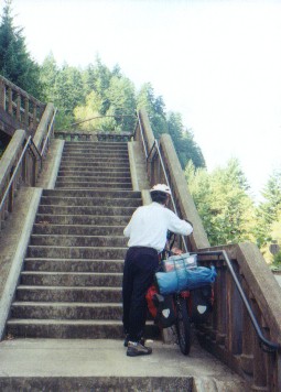
Early on this road was pretty much the venue of the rich from Portland. They were the only ones with the cars. But, very soon even the working class could afford to buy an auto and traffic along the road grew and grew. Rather than just a place for a leisurely Sunday drive, the Columbia Gorge Highway became a major transportation corridor to the east. It wasn't too long before there were calls for a flatter, straighter, wider, more practical road. In the 1940s the water grade I84 was started and in the 1960s the second set of 2 lanes added making for the super interstate highway there is today. Unfortunately in all this progress, much of the original Scenic highway was plowed under. Today only 1/3 remains. Some of the road is being renovated as a hiking/biking route. But, much is lost for good. By the time we had arrived in Portland the second major cold front of the season had come and gone. We wound up spending a day in the little community of Corbett, relying on their tiny market for meals, while very chilly rains pelted our tent at odd intervals throughout the day. The next day we saw new snow dusting the tops of the high peaks of Mt. St. Helens. Chilly days and cold nights were not far behind. Our passage through Portland was, thankfully, uneventful. Portland is a reasonably biker friendly city. Many streets have bike lanes painted on the sides and there is a fair number of separated bike paths. Even the two major bridges crossing the Columbia and some of the bridges crossing the Willamette have bike paths. So we had no trouble passing through even with a side trip to the REI store to pick up supplies. Route 30, on the other hand, isn't quite as pleasant. There are two ways to follow the Columbia to the coast, neither of which is an enjoyable ride. One is on the Washington side and the other Route 30 in Oregon. Both carry a lot of traffic and Route 30 has a lot of truck traffic. Typically there is a good shoulder, except when climbing uphill where the shoulder is traded for a passing lane. But still, all that truck traffic is noisy, requires constant attention, and results in all kinds of junk on the sides of the roads. If we were to pass from the coast to Portland again and weren't intent on following the Columbia river, we'd probably opt for a much quieter, probably tougher, road. Route 30 we won't likely do again. "Great joy in camp we are in View of the Ocian, this great Pacific Octean which we been So long anxious to See. and the roreing or noise made by the waves brakeing on the rockey Shores (as I Suppose) may be heard distinctly", Wm. Clark, November 7, 1805 The Corps had arrived at the Pacific Ocean just at the start of one of Oregon's infamous long, dreary, wet winters. They had hoped a trading ship would happen by to either give them supplies and take their notes back home or even to give them a lift. Yet, despite the fact it is believed that trading ships were in the area at that time, none happened to pass by their location. So, after exploring a little of the north side of the Columbia, they took a vote of their corps members and decided to move to the south side where the natives assured them good quantities of game could be found. This vote was rather significant in that absolutely everyone was allowed to partake, including York the slave and Sakajawea, a woman. After Capt. Lewis scouted out a site, the entire party moved across the Columbia and proceeded to build their little wood log huts in the soggy, boggy lands now just southwest of Astoria. Here they would spend one long, wet winter where the sun would shine only a couple times We can easily imagine their relief to finally be within sight of the Pacific ocean. Even as we approached Astoria we could feel the longing to be near the sea once again. We love the mountains and enjoy traveling inland. But, we always feel a certain homesickness for the ocean whenever we are away for a long period of time. There's just something about being near the water that feels like home. So as we passed through Astoria and rode on to the Fort Stevens State park we both felt glad to be back. "I've missed the ocean." we both commented on numerous occasions. "Rained without intermition all the last night and to day with Thunder and Hail the fore and after part of this day. Capt. Lewis and my self move into our hut to day unfinished.", Wm. Clark, December 23, 1805 References1. The Journals of Lewis and Clark, Edited by Frank Bergon, 1989, Penguin Books USA, Inc., New York, NY. 2. Whitman Mission, National Park Service Brochure, Whitman Mission National Historic Site, 2003. Appendix A - RouteMontana August 19 - 39.42 miles Rt 12 west from Helena, Dog Creek Rd north, Rt 1855 to Bald Butte Mine Idaho August 29 - 33.87 miles Rt 12 to Jerry Johnson Campground Washington September 6 - 39.72 miles Rt 12 to Pomeroy Oregon September 10 - 35.4 miles Rt 12 to Rt 730 to Umatilla Washington September 11 - 30.14 miles Rt 14 to Crow Butte Park Oregon September 13 - 56.54 miles ACA route to Viento State Park
Appendix B - Campsites or hotelsMontana August 19 - Bald Butte Mine Idaho August 29 - Jerry Johnson Campground Washington September 6 - Pioneer Motel ($40) Oregon September 10 - Umatilla RV Park & Marina ($12) Washington September 11 - Crow Butte Park ($20) Oregon September 13 - Viento State Park ($14) |
|
Copyright © 1995-2011 by Caryl L. Bergeron - Distribution for personal use permitted. Distribution for other uses with written permission.
Acknowledgements
|
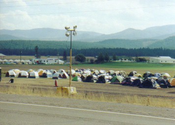 In the meantime, forest fires seem to have almost become an institution. During summer months huge tent cities sprout up in fields near the major fire complexes. They include a variety of tents ranging from big family sized domed contraptions to little one person backpacking wedges. Huge YURTS and house sized tents make up the kitchen and other facilities. Blue port-a-potties are scattered throughout. Big semi trucks bearing some sort of Mobile Catering service logo service the crowd. During the day the camps are quiet. At night they must come alive with tired, sweaty, smoke scented fire fighters. If you love the outdoors, it's probably a satisfying job but it does look like it's exhausting and dirty.
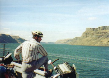 However, having this first front over would actually prove to be beneficial for our passage through the Columbia Gorge. The Columbia gorge is one of the most unique geologic features of the northwest. While the Cascade mountain range soars to heights of thousands of feet, the Columbia river passes clean through at nearly sea level. It was created by two distinct geological events. The river has existed since before subduction of the Pacific plate caused the uplifting of the Cascade range. As the mountains lifted over millions of years, the river continued to cut a channel through to the ocean.