| Caryl and Brian's World Bike Tour |
|
Great Rivers South - 2003 Tour Part IV |
![]()
![]()
![]()
![]()
|
|
LEWIS AND CLARK ROUTE 3 - 2003 TOUR PART IV Laurel, MT to Helena, MT July 18 to August 5, 2003 Start 43,317 miles (69,307 km): End 44,090 miles (71,112 km) cumulative
Teasers:
"we breakfasted and set out about sunrise and continued our rout down the river bottoms through the mud and water as yesterday
When the sun rose, so did we. Searing heat was in the forecast with no end in sight. At 6 AM the temperature was around 60 degrees. By 12 noon it reached 98, 99, over 100 and it just hovered at those high ranges until sunset. This was that energy sapping kind of heat that could so easily turn a good biking day into a day spent flirting with heat exhaustion. We quickly learned that the only way to beat the heat was to get up with the sun, ride 30 to 40 miles, and then retire to a shady corner for the rest of the afternoon. We could ride a little more in the late, late afternoon, but as the sun was always nearly set by the time it got even just a little cooler, we usually just stopped. This was unusual weather, as always. Somehow we knew right at the start of this year's tour that once again we'd be hearing that old familiar phrase "It's been unusually _____ this year." The blank was filled in with "wet and cool" earlier in the spring and then filled with "searing hot" for July. In fact, having almost zero winds in the town of Livingston, just north of Yellowstone National Park, as well as easterly winds which pushed us up to Livingston in July is almost unheard of. Under normal circumstances the cool air from the mountains roars down the highway toward the east to fill in the void left by hot air rising in the nearby prairies. This close to the mountains is about the only place where the old myth of westerly winds usually does apply. But, not always, as this year proves. So windwise, we've been extremely lucky. If Montanans knew our record with drought, they'd permanently ban us from ever touring there again. This was the fifth time we'd ridden through Montana. Our first tour was in 1988, the year Yellowstone burned. Our fourth tour was in 2000, the worst fire year in Montana's history to date. And now, in 2003, the drought continues, the fires continue, the heat wave continues. So three out of five tours through Montana have been in drought with fires. We are beginning to think that's all there ever is. Since we hadn't had much rest since leaving Williston, N.D. we concluded that it was time for a break. Livingston seemed an ideal place. It's located just about 100 miles north of Gardiner, the real entrance to Yellowstone, and just a little east of Bozeman Pass. It's where Clark, on his return from the Pacific, stopped to paint his name on a cottonwood tree by the river. That tree, thought to have stood in the present Sakajawea town park, has long since disappeared. From here the small contingent of the Corps of Discovery hit the Yellowstone River and headed down river. Being so close to the nation's first national park, Livingston's history has always revolved around the park. Very early on it was the main train stop for wealthy tourists visiting the park. They'd disembark at the station to be whisked away aboard one of the waiting horse drawn carriages to the lodge at the northern entrance of the park. Later a spur line was added to take them directly. In 1902 a beautiful Italian renaissance style station was completed. Downtown is filled with well constructed brick buildings clearly a prominent display of the area's wealth. Today Livingston is still a big stop before heading into the park. It has two huge grocery stores despite being a fairly small town. There are hotels, motels, restaurants, and gift shops all of which are abuzz with activity in summer. There are even two museums, one about the railroad crossing the rockies housed in the recently renovated train station, and another about local history housed in an old school house. Essentially anything you could possibly want for an excursion into the park can be found in Livingston. Tossing a coin, we decided to visit the Yellowstone Gateway Museum, the one in the school house. We were hoping it would be the more interesting of the two. As it turns out it is one of those types of museums we've given the nickname "attic" museums. You see these all over the U.S. Nearly every small town has one. They take an old building, do some renovating, and then start collecting stuff. After a while they begin to look like everyone in town has emptied their attics putting all their old, unwanted stuff in this old building. A sign is added on the outside and, voila, a museum is born. There is always far too much stuff and too many duplicates. An example of one mechanical adding machine is more than enough. Five is too many. Sometimes things are somewhat organized, more often they're not. Rarely is there a cohesive story. Almost never is there a theme. Usually there are tons of photos of people who may have been of local interest, but again no story to match. A genealogist would find all these photos to be a treasure trove. The rest of us would find one or two to be enough. Almost every museum houses the same stuff. There'll be a school house, pioneer house, black smith shop, a few wagons and carriages, maybe a 1930s Ford model A or T, kitchen utensils, farm machinery, etc. Museum after museum has essentially the same things. About the only variation we can find comes when you change regions. Museums in the east can have all sorts of odd farm equipment especially old horse drawn plows and such. Museums out on the prairies usually include a sod or tar paper house, sheep herder's wagon, pioneer's wagon. Museums in the mountains have gold mining stuff and maybe railroad paraphernalia. Yet apart from these slight regional differences we've concluded that after you've seen one or two of these types of museums, they all begin to look alike. We now try to limit our time spent in these museums. We pick and choose only those that seem the best, although even still sometimes we goof. After a day of rest we decided to push onward. It was tempting to take off down the road toward Yellowstone Park, a route we've never followed by either bike or car. But, seeing it was the middle of the summer tourist season and there was a fairly significant amount of traffic, especially giant RV traffic, and we still needed to get to Helena by early August, we resisted that temptation. So we headed west over the Bozeman Pass, our first mountain pass of this tour. At just 5760 ft, Bozeman Pass is not exactly the highest nor hardest pass we'd ever ridden, but it was a milestone nonetheless. It was a clear sign that we really had reached the mountains. We huffed up and over early in the morning while there was still a slight hint of the nighttime chill in the air. We reveled in the pine clad mountains we'd been so longing to see. All too soon we glided back down in altitude to the lower valley where the city of Bozeman now sits. The Bozeman Pass is the one region where Sakajawea actually did provide the guiding services for which she's become so famous. Clark even labeled her a good "pilot." Her people, the Lemhi Shoshoni, would travel from the west side of the mountains to the east to hunt buffalo. One of their routes was through Bozeman Pass, which is why Sakajawea was familiar with it. We followed frontage roads along the interstate highway. They took a path a bit further north, avoiding an area where Sakajawea said enemies might lurk. At this point they still had the horses they had obtained from the Shoshoni. These would later be stolen, probably by the Crow, a bit further east. As soon as they hit the Yellowstone their search for cottonwood trees large enough for canoes would begin. It would take a long time for this search to be successful. "Shields renewed the main-spring of my air-gun we have been much indebted to the ingenuity of this man on many occasions; without having served any regular apprenticeship to any trade, he makes his own tools principally and works extremely well in either wood or metal" M. Lewis, June 10, 1805 All equipment from air-guns to bicycles, when used day in and day out, eventually needs repairs and replacement. Fortunately, we no longer need to rely on the ingenuity of a blacksmith. Bike shops will normally have everything we need. Yet, out in the prairies, finding these bike shops is not always that easy. Discount stores, such as Wal-Mart and K-Mart, and hardware stores, ACE and Coast-to-Coast, might have a few odds and ends. But, high quality parts are hard to find. So we were absolutely delighted to find Bozeman had not just one, but four well stocked bike stores. Of course, this may have something to do with the fact that it is a big college town and a very yuppie one at that. So in Bozeman we replaced chains, cables, and, now that we were back in the mountains, put a nice, aggressive knobby tire on the back. Dirt roads here we come. Bozeman is one of those towns that was "discovered" by Californians and the "rich and famous" about 10 years ago or so, much to the consternation of the long-time locals. They've built huge, million dollar "ranches" up in the hills and then completely redone the downtown in the image of a yuppie, upscale California neighborhood. Main street is lined with expensive looking trinket shops and bistros including a microbrewery. We spoke with one local who was born and raised in the area. He told us his folks, ranchers living way out in the country, don't even come to town unless absolutely necessary. They hate what's happened to it. We also learned some rather revealing items about these rich California wanna-be ranchers. Evidently they come into the area, build these huge ranch houses, then put up fences to enclose their property. Evidently these fences are blocking the instinctual migration routes of some of the elk. The elk get to one of these fences and they simply cannot adapt. They get stuck and starve. We were told one of the big offenders in this is the supposedly environmentally concerned Ted Turner. That's right. He built a huge ranch out in the forests, bulldozed the hillside to get a better view of the lake he had built, and then put up all those elk stopping fences. This is the guy who so much wants wolves in Yellowstone National Park he's willing to try to train wolves not to attack cows by using electric shock, a plan doomed to failure if we ever heard one. Bozeman is one of those places that attracts a bunch of odd people. Imagine what the good-ole-boy ranchers clad in their jeans, flannel shirt, and baseball cap must think when some college age boy sporting bright blue, spiked greasy hair, arms full of tattoos, and a gazillion pierced body parts passes by. It is a college town after all. There are a lot of the "homeless" on the streets. We've all seen them. They stake out busy corners, especially at interstate off ramps. There's always a cardboard sign, pleading for money, with some sort of gimmick. It used to be "will work for food" until people figured out these panhandlers had no intention of working for anything. They just want money. Today's schtick seems to be "homeless Vet needs help." Uh huh. Yeah, right. Bozeman does have one of the best museums in the state. The Museum of the Rockies is a must see for anyone interested in the history of the region. It covers everything from the Big Bang through the 1930s. It pays particular attention to the dinosaur finds of the area. Of the 11 or so partial T-Rex skeletons that have been found to date, this museum has 8. They make and sell copies to help fund their research. So if you ever wanted a T-Rex skeleton for your living-room decor, here's the place to go. They also have a unique collection of eggs and young dino skeletons for three separate species. Back in the days when the center of the continent was covered by that shallow sea, the dinosaurs would spend a majority of their life along the shores where plants were most abundant. However, this was not the place to lay and hatch eggs. This was done uphill in a drier, less silty region, which is an environment not prone to make lasting skeletons. However, it happened that sometime, long, long ago, a major mud slide did bury a cache of eggs, young, and adults. Found in 1978, this cache has yielded tons of new insight into the maternal behavior of dinosaurs, all of which is on display at this museum. There's a cross section of a 1930's house as well. But, it's not just the usual house with contents display. They actually go into some detail into the construction. The house, which really is a 1930s house, has cut-away walls showing the interior wall stud placement and explanations tell why certain things were done. For example, most Montana prairie houses had white walls with black window and door trim. This was not just for esthetics. The black around the windows and doors helped keep them from freezing in winter. The white walls kept the interior cool in summer. Smart, eh? A soon-to-be addition to the museum will be the Lewis and Clark adventure center out back. This is going to be a hands-on recreation of the entire journey geared more specifically to kids. Everyone is given a small pouch containing trade beads, a piece of leather, a gum ball, a peace medal sticker, and other odds and ends representing things L&C took with them. They then get to go through the entire expedition and do stuff along the way. They'll get to try their hand at pulling a canoe along a track, mimicking the corps' portage around the Great Falls. They get to try shooting for game, the use for the gum ball. They'll see how the Mandan planted their corn. It looks like there'll be a good half day's activities for the kids. But, as with several of the Lewis and Clark interpretive sites, it wasn't ready when we went through. "we proceeded on a fiew miles to the three forks of the Missouri those three forks are nearly of a Size, the North fork appears to have the most water and must be Considered as the one best calculated for us to assend", Wm. Clark, July 25, 1805 We continued on down the valley to the town of Three Forks and the corresponding state park. The town is actually placed a few miles upstream from the actual place where the river splits. The forks region is contained within the state park. There are picnic areas, hiking trails, and a nice campground. It was a hot, sunny day and the water was beckoning. We slipped into our swimsuits and plunged in. We can now say we have dipped our tootsies in the headwaters of the Missouri. By the time Lewis and Clark arrived in this region they had already made the fateful decision to follow the southern fork at the intersection of the Marias River, stashed the two pirogues, and undertaken the arduous portage around the Great Falls. The Marias posed quite a problem to the corps. Information they'd obtained from the Mandan indicated only a single major fork prior to the falls. They'd already passed one major fork, the Milk River, and thought that was the one the Mandans' meant. Now here was a second. The question was, which way to go now. The Marias headed north and was a silty, muddy river. The other fork headed southwest and was a clearer water. With the exception of Lewis and Clark, the corps members all thought the north running fork was the one to follow. They reasoned that the entire Missouri they'd followed so far had been muddy, why should it be different further upstream. Lewis and Clark reasoned that a clear running river indicated it flowed a much shorter distance in the prairies which may mean the mountains were not far ahead. The captains overruled the crew and they headed down the southern fork. Before long their decision was vindicated, they came to the Great Falls which the Mandans had said they'd find. Much to their chagrin they discovered not just a single plunge, there was a whole series of falls spanning a distance of about 18 miles. I can only imagine their dismay as they crested one cataract only to hear the booming noise of another and another and another further ahead. To get around these falls they had to portage their gear and boats a full 18 miles over extremely rough, deserty terrain. They tried the iron boat they'd brought all the way from the east, which immediately sank. so the lightweight option was out. They wound up building a rough set of wheels on which they placed those extremely heavy, solid wood canoes and proceeded to brute force them one at a time around the falls. All the while they had to deal with snakes, heat, and constant prickly pear thorns piercing their moccasins. The whole ordeal took them over 3 weeks to complete. Yet they persevered. Lewis and Clark named the three forks for three men who were instrumental in getting their expedition off the ground; Thomas Jefferson, James Madison, and Albert Gallatin. These names have survived while many of their others have not, at least for part of the further upstream river. They spent several days climbing nearby mountains and exploring each of the forks trying to determine which was the best to follow. They finally followed the northern fork, the one named Jefferson, as it seemed to have the most water and was most navigable. When they got to the Three Forks they were desperately looking for Sakajawea's people, the Shoshoni. They knew that to pass over the mountains to the headwaters of any of the tributaries of the Columbia with all their gear would require a lot of horses. In fact, the success or failure of their expedition hinged entirely upon getting horses at this point. Yet, day after day passed and no Shoshoni appeared. They hadn't seen any Indians for a long time. There'd been recent signs and encampments only. It would be a few more weeks and many more miles before they'd find them. We continued from Three Forks along a back road that took us by a rather unusual outdoor rock concert venue, by the Lewis and Clark Caverns state park, and finally through a beautiful canyon to the town of Whitehall. Once a year it seems crowds gather in a field for a Rockin the Rockies concert. Yet, the field appears set up for this one event all year. It has fences, gates, out buildings for food sales, and the most odd stage. The stage appears to be an old steel truss bridge. It's quite strange. You approach this bridge and, not knowing what it's for, you wonder what in the world this bridge crosses. Nothing. It's just in the field to be used for a stage. Lewis and Clark Caverns State Park is listed as one of the "must see" places by the AAA. We had considered a visit, even planned on camping there. We rolled on up to the entrance, raised our chins with our eyes following the upward curving spiral of the road, and immediately had second thoughts. The caverns are a full 1100 ft. uphill. Costs for the 2 hour visit are about $10 per person and camping was $15. Well, we're not exactly avid spelunkers. To us a cave is a cave is a cave and one looks about the same as the next. We looked at each other, at the road, at the costs. Forget it. Onward we rode. Whitehall happened to be having their annual Frontier Days starting that evening. It would have been nice to stop and take advantage of the evening bar-b-que put on by the fire department and the entertainment that was sure to follow. But, lodging was booked and the RV park looked like a dive. So we headed on. However, not before taking advantage of the super ice cream sandwich price of $.25 at the nearby Town Pump, WOW.
"two miles below Mc. Neal had exultingly stood with a foot on each side of this little rivulet and thanked his god that he had lived to bestride the mighty & heretofore deemed endless Missouri.", M. Lewis, August 12, 1805
Unfortunately, as with so many of the National Forest and Park sites, this little piece of heaven is soon to be invaded by tourists, way too many tourists. The western approach to the pass is an extremely steep, rough and rocky road which is really not a place for buses or RVs. The east approach, on the other hand, has been continually upgraded making bus travel possible. Even as we passed they were rebuilding the top 1/2 mile of the road and were about to start a complete reconstruction of the picnic area at the spring. All this was to facilitate tour buses getting to the site. In summer for the next few years they are also placing an interpreter at the pass to answer questions. Now normally when we climb up a dirt road to a Forest Service pass we're about the only people there. What a surprise it was to get to the top of Lemhi to find a veritable crowd. There was the interpreter, three vans full of history students, a few other cars with couples, and the construction crew. I can only imagine that even this number of people will increase substantially by 2006. Buses, yuck!
Lewis and Clark's assent of the Lost Trail Pass was steep and treacherous. They mention on several occasions the horses slipping, falling, and rolling over. Several were lost due to injury and death. Today a paved road has been etched into the sides of this steep climb having gentle grades of no more than 5%. For us, getting to the top took only a continual use of energy. Modern roads are definitely a great invention. Fires had come to Montana once again. This was the fifth year of a severe drought and conditions were ripe for flames. Experts agreed that 2003 had the potential to be an even worst fire year than 2000. Moisture levels in the forests were in the single digits. The wet spring left behind some denser undergrowth that now was dry and crisp. If the record heat of July continued on into August there could be serious trouble. As we climbed up to Lost Trail Pass and then descended from Chief Joseph pass we were going right through the remains of some of these fires. Fire crews worked the sides of the road chopping trees. Helicopters buzzed overhead towing buckets of the slurry they dump on hot spots. Fire department trucks passed back and forth on the highway while pilot cars led the civilian cars through. Being on bike, we were allowed to pass without the pilot cars. But, try to stop and you get a tongue lashing. One of the women in the pilot cars yelled at us telling us that if we don't keep moving she'd pick us up and carry us to the top. Funny thing was, it turned out she was wrong. Just a bit further up the road a fire fighter asked us to stop each time a helicopter passed over. They can't pass over people or cars and it's easier to miss a still target than moving, not that we move fast enough to be hard to miss. Anyway, we felt rather vindicated knowing this lady was wrong. At Lost Trail Pass we would be leaving the Corps of Discovery's westward bound trail to make a detour to Helena. Turning right at the top of Lost Trail Pass we pursued the route followed by Clark on their return journey, a short cut. But, our objective was to get to the little town of Polaris where we could pick up the Great Divide Mountain Bike route northward. Granted it's not exactly along the Lewis and Clark trail, but the objective of their journey was to explore and that's what we'd be doing. It is always amazing how, with time, the difficult times seem to mellow and become mere shadows of their former experience. It'd been three years since we'd ridden the GDMBR from north to south and during this time it'd gone from a grueling, tough ride to an enjoyable dirt road trek in our minds. It's easy to forget just how steep and long those dirt road climbs can be. Our memories were quickly refreshed as we rode up, up, and up north of Polaris toward the noname pass which led to the Wise River valley. Oh how fast we remembered just how easy pavement riding really is. It was particularly easy to forget just how tough the infamous Fleecer Ridge could be. Coming down was bad enough. Now we actually made the conscientious decision to go up. Now this is the hill that ACA recommends you descend by walking your bike back and forth through the bushes on either side of the steep ATV trail. It is also the hill that took the fellow we met 4 hours to ascend three years ago. He'd climbed with the bike, then bags, then B.O.B. trailer. We stood at the bottom of this 45 degree loose dirt hill thinking it looked a whole lot steeper, looser, and harder standing at the bottom with a loaded bike to go up than it did standing at the top going down. We gulped down some water, donned our baseball caps, and started pushing the first bike up. Remarkably we happened to arrive at the bottom of the hill just when a European couple were also making their way uphill. They had already gotten one bike up, one with just panniers. Now they were working on the bike with the B.O.B. I imagine there are only a few people who tackle this hill south to north each year and still fewer who do it with a loaded bike. So to meet up with a couple doing exactly what we were doing right at the bottom of the hill had to be another one of those strange coincidences we so often experience. Getting a loaded bike up this hill requires one person pushing in front and the second pushing from behind. It looks double difficult with a trailer. You shove up about 50 yards, rest, shove another 50, rest, and so on. It's an exhausting, backbreaking task. To get through I just kept thinking about the Corps of Discovery pulling their heavy canoes that 18 miles around the Great Falls for 3 weeks straight. If they could do that, then surely we could get these bikes up this one hill. Two hours 20 minutes and two trips later we finally had both bikes at the top of the hill. Unlike our European counterparts, who immediately took off down the road, I suppose they were on a schedule, we chose to rest for an hour or so and enjoy the fruits of our labor, the magnificent scenery. So we'd now be willing to bet that we are just about the only people who've taken loaded bikes both direction on Fleecer Ridge and probably the only ones who decided to go up the ridge after having gone down first. Yes we are a little crazy sometimes. There were more surprises in store as we continued toward Helena. We'd completely forgotten about the 3 to 4 miles of rough, highly technical trail just north of the little town of Basin. We entered this section just as a group of unloaded, sagged tourists were leaving. Even without loads they had wound up walking a few times. They kept saying, "We're not worthy and we should bow down at your feet" when they saw us. Maybe we're just too insane. But, we pushed on, walking where the trail was too rough, taking a few flying falls into the bushes, splashing and falling into mud puddles. It was tough, but we did it. And we'd be back for more punishment when we headed north out of Helena in 2 weeks. For now it was time for a break, rest, and visit with the family in Michigan. Then, we'd be back at it. "we called this creek Travellers rest." M. Lewis, September 9, 1805
References1. The Journals of Lewis and Clark, Edited by Frank Bergon, 1989, Penguin Books USA, Inc., New York, NY.
Appendix A - RouteMontana July 18 - 34.89 miles I94 to Park City, Frontage road to Columbus Idaho July 29 - ACA route Lemhi Pass to North Fork Montana July 30 - 52.88 miles Rt 93 to Lost Trail Pass, Rt. 43 to Wisdom
Appendix B - Campsites or hotelsMontana July 18 - Iche-kep-pe City Park Idaho July 29 - North Fork Cafe & Campground ($12) Montana July 30 - American Legion Park, Wisdom |
|
Copyright © 1995-2011 by Caryl L. Bergeron - Distribution for personal use permitted. Distribution for other uses with written permission.
Acknowledgements
|
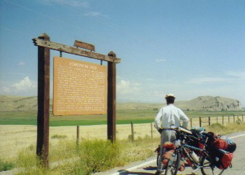 Dillon provides an opportunity to choose route options once again. One choice takes you over Big Hole and Chief Joseph passes, going by Bannock State Park, following the route Clark and company took on their return trip. The second option goes over the Lemhi Pass, up the Salmon River, and then over Lost Trail Pass following their route on the way to the coast. Today the first option has all paved roads and it's a route we've already followed. Lemhi Pass is more rugged and unpaved. What the heck. Let's go for the dirt. Actually, we needed to get to Helena, so we decided to go over Lemhi, Lost Trail, Chief Joseph, and Big Hole passes so we could pick up the GDMBR in Polaris. Let's really do some dirt.
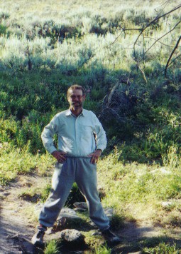 We can't agree more and after following the Missouri for many months ourselves we just couldn't resist doing the same. You have a steep, difficult climb up a reasonably good dirt road to the top of the absolutely spectacular Lemhi Pass. Just a few yards from the top is a babbling spring which, even in this wretched drought, is still gushing forth with wonderful, clean spring water. Lewis and Clark declared this to be the start of the Missouri. In reality, there is another spring further south which would add many more miles to the Missouri's length, but as the National Forest Lewis and Clark interpreter told us, for the Corps purposes it was close enough. For our purposes, this spectacular high altitude site made for a perfect spot for a campsite. You can't camp at the spring, it's been declared off limits for camping as a National Historic Landmark, but there are plenty of wonderful spots in the nearby forests. Heaven on a dirt road.
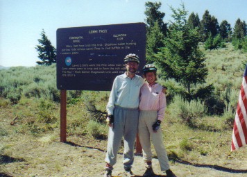 He commented that the only way to pass along the shore would be by cutting a road into the side of the cliff. Today that river is called the River of No Return and, ironically, that road cut into the cliff has been built. This "impossible" river to pass has become a favorite white water rafting run. Clark returned to the Shoshoni camp and the entire Corps headed out on foot, under the guide of one of the old Shoshoni's named Toby, north along the valley up to the Lost Trail Pass and over to the Bitterroot Valley.