| Caryl and Brian's World Bike Tour |
|
South America Adventure Part 2 - Argentina |
![]()
![]()
![]()
![]()
|
|
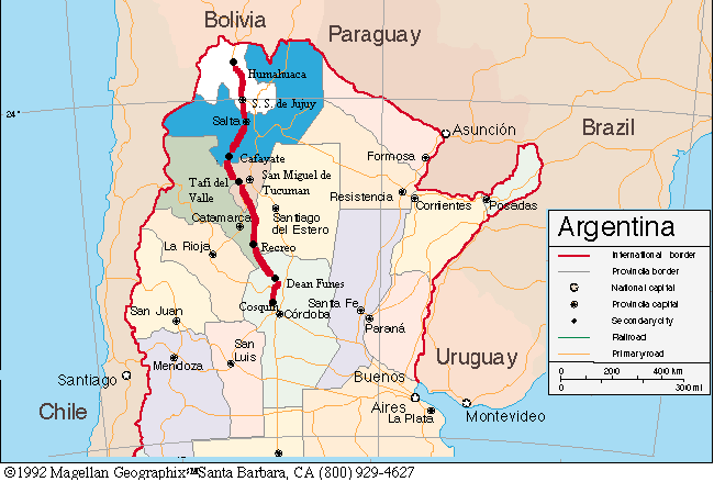
SOUTH AMERICA ADVENTURE PART 2 Buenos Aires, Argentina toTafi del Valle, Argentina February 25 to March 23, 2001 34,232 miles (55,212 km) cumulative
Teasers:
"Send me out into another life. But get me back for super." View PhotosDay 24, 25, 26, 27, 28, 29, 30 - Buenos AiresOn to the thriving megalopolis of Buenos Aires, just a short 40 minute hydrofoil ride across the Rio de la Plata from Colonia del Sacramento. With a population of just over 11 million, it's a city of energy and traffic. Also a lot of nutty drivers. After the quiet cities and towns of Uruguay we were not altogether ready for a busier world. Spain's first attempt to establish a settlement at Buenos Aires in 1536 failed after just 5 years. The local natives, not particularly interested in having these strangers interloping on their lands, made life just plain miserable for the inhabitants. So the Spaniards moved upstream to today's sight of Asuncion, a location where the natives were already settled in small farms and were a lot easier to subjugate. They then worked their way back downstream, refounding the town of Buenos Aires in 1580. The town had virtually no resources, at least not to the Spaniards whose interests were principally the gold and silver mines in the Andes mountains. There was essentially the wild horses and cattle which had thrived on the grasses of the pampas and spread with astounding rapidity. By 1750 the town's population had reached about 14,000 and its economy rested on trade in hides. A vibrant trade with the contraband Portuguese town of Colonia del Sacramento across the river was in full swing. Population in the town was further bolstered in 1776 when Buenos Aires was selected as the seat of the large Spanish vice-royalty of Rio de la Plata and again in the early 1800s after gaining independence and opening as a free trade port. In its early days Argentina was far from a unified country. There were 2 major sectors of population. The city dwellers who wanted a centralized form of government which, of course, favored Buenos Aires, and the country folks consisting primarily of gauchos and large landowners all of whom favored a distributed form of government. This lead to quite a few civil wars and even at one point Buenos Aires was sort of kicked out of the country, made to fend for itself. The whole issue was finally resolved in 1880 when the city of Buenos Aires was separated from the province of Buenos Aires and made into a federal district similar to the U.S. Washington D.C. It was declared the country's permanent capital at the same time. In the meantime it's greatest period of expansion started in the 1860s. As the major port of Argentina, it flourished on an export trade of hides, wool, grain and meat. It was also a great draw for European immigration especially from Italy and Spain. Foreign capital poured into the port, mainly from the British, who built the extensive railroad system that radiated from Buenos Aires to all parts of the country, the modern port facilities, streetcars, and gas works. By 1910 the city's population had reached 1.3 million and it had emerged as Latin America's leading economic and cultural center. Keep in mind that at this time Argentina was one of the wealthiest countries in the world. In the 1930s the city began to concentrate on developing an economy based more on industry rather than just import/export. Factories producing consumer goods located near the federal district which attracted migration from the interior of the country as well as from abroad. Eventually interior migration exceeded that from Europe. By 1950 the town's population had reached 5 million and today it exceeds 11 million. The federal district and its suburbs spread out over an area of 200 sq. km and its inhabitants are mainly of European descent; Italy, German, France, England, and Spain. It is said that "an Argentine is an Italian who speaks Spanish, wishes he were English, and behaves like he's French". (Lonely Planet Argentine, Paraguay, & Uruguay) A person living in Buenos Aires is referred to as a porteno (tilde over the n), a name derived from an Argentine born person of European descent living in the port district of Buenos. The majority of Buenos Aires is just a working city with little of tourist interest. The main tourist sights are contained within the 5 oldest districts, San Telmo, Recoletta, la Boca, Plaza de Mayo, and Palermo. We began our explorations with the task of locating a suitable, and relatively inexpensive hotel. Once settled into the pretty nice hotel, Tres Sargentos, we began our explorations which consisted of walking enough each day such that every night our feet felt as though they'd fall off. There was a lot to see. We started toward the north in the wealthy barrios of the Recoletta. Recoletta is famous for one main thing, a cemetery. Within one block of the city is the single location where anybody who is anybody in Argentina gets their body placed after they've left this world. It's not just a matter of how much money you have. You must also have the correct parental lineage or be a supreme national hero, like Lavalle. Enclosed within the high block walls is an area that looks like a miniature city. Tiny mausoleums look like little houses. There's every imaginable architectural style from Greek revival and Gothic and Renaissance and art deco. They all have doors and many have windows so you can have a peak inside. Inside you'll see a couple of caskets, covered with a white table cloth and a lot of old dust. Sometimes there are photos of the deceased and in many there are staircases to levels below. There must be a lot more than 2 bodies per little house. You could spend hours wandering around looking at the strange streets of this city in miniature all the while hunting down the names of some of the most important people of Argentine history, Eva Peron for one. It's one bizarre place. We continued onto the Palermo district primarily to visit the gardens. This district owes its expansive parks and gardens to one of the main figures in Argentina's history, the dictator General Rosas. These gardens were once part of his extensive estate holdings. After his demise, in 1852, the lands were turned over to the city as a huge system of parks. The residential areas of Palermo and the Recoletta are called home by some of the wealthiest people of Buenos Aires. They moved there from the San Telmo district to escape a yellow fever epidemic in 1870s. San Telmo has since been turned over to a middle class who owe their roots to the many emigrants who were pouring into the country at that time. The most beautiful garden in the district is the incredibly well maintained Rosedale which has a very large rose garden. I had to take a closer look. Not only were there no weeds or bugs, but not even any leaf rust which is the most typical problem for rose gardens. The parks of the Palermo district spread well beyond the Rosedale, but that was our favorite. At the other end of the city and opposite extreme on the economic scale is the port region of La Boca. In it's early years La Boca was essentially a port side shanty town consisting of quickly and shabbily constructed tin sided buildings. It was home to the poorest emigrants just off the boat, prostitutes, gambling halls, sailors haunts, and just about any other kind of vice you can imagine. To spruce up the place a bit, the residents would use paint left over from painting boats to paint their shacks. Naturally this lead to a very colorful array of buildings. If you read the tourist literature you get the impression that many of these colorfully painted houses still exist. I imagined block after block of imaginative and garish color. In reality La Boca is not much more than a slum. Sure there are some, and I do mean just a few, of those colorful houses left, about one and only one block. That's it. Even the street that the Lonely Planet book claims is lined with unique cantinas offering interesting atmosphere has exactly 4 such cantinas, all on one corner. It is also home to one of the most polluted bodies of water we've ever seen. All in all we found the La Boca district to be a huge disappointment. If you you ever go to Buenos Aires and happen to skip the La Boca area, believe me you won't be missing a thing.
Play your cards right and you can see most museums in Buenos Aires for free. The fine arts museum, always free, has a wonderful display of paintings and statues ranging from medieval times to present. Names like Rodin, Manet, and Picasso are represented. We enjoyed most of it, but somehow a piece of canvass that literally looks like someone simply threw paint at it fails to inspire us. Visit the Museo de Ciudad on Wednesday and it's free. Thank goodness as it's not worth even the $1 peso entry. There are about 2 tiny rooms which contain almost exclusively old photos of the city. There are almost no relics, antiques, or anything representing the city on display. Miss this and you won't miss much at all. Another odd museum, thankfully free everyday, is the Museo National Ferroviaro. It's supposed to be the national railroad museum and, I guess, the majority of the relics on display do have to do with the rail system. There are are some train models, train conductor caps, some seats from rail cars, a few pieces of equipment, and at least 3 old rail bikes. But there are also a lot of nonrail related items such as a bunch of old phones hung on one wall and a couple of huge, old electrical experimental devices. One strange and woefully disorganized museum. Two other really good museums were the Museo de Arte Hispanoamericano, free on Thursdays, and the Museo Historico National, always free. The first has a wonderful display of art and furnishings from the Spanish era of Argentina. The amount of beautiful silver pieces on display is quite remarkable. The history museum has an extensive and well organized display of artifacts from Argentina's history from Spanish conquest through 1950. Each room covers a specific time in the country's history and has an explanation of what happened during this time. I was amazed at the number of genuine artifacts on display that came from the actual generals and other important figures in Argentina's history. In particular there are quite a few artifacts from General San Martin, the equivalent of the U.S.'s General George Washington. Unfortunately the basement, containing the years 1880 to 1950, was closed when we visited. In architecture, Buenos Aires can in no way compete with some of the other Latin America colonial cities such as Oxocaca, Merida, or Zacatecas. For museums it doesn't even come close to Mexico city or Vienna. The atmosphere and environment is that of any big city anywhere else in the world. After 5 days exploring we'd had enough big city life. We'd seen everything we could ever want to see of Buenos. Time to leave and, with the exception to pass through out, we will not be back. Argentina's early history is essentially the same as Uruguay's. Solis discovered the Rio de la Plata and proceeded to get himself offed and eaten by the natives. Then attempts to settle Buenos Aires in 1536 failed within just 5 years. But eventually the Spanish did manage to get a foot hold moving in from Spain, Peru, and Chile. Throughout the next few centuries trade was tightly controlled by mother Spain through that indirect, expensive, and frustrating Panama to Lima to Buenos Aires path. In 1776 Spain established the viceroyalty of the Rio de la Plata with Buenos Aires as its capital, thus recognizing the growing importance of Argentina. When Spain allied with Napoleon, or you might say Napoleon took over Spain, the English attempted to take Buenos Aires by force. They occupied the city in 1806 and 1807 but were repelled by the locals. In May 1810 the locals, feeling bolstered by these victories, decided to rebel against Napoleon and declare loyalty to Ferdnand VII. Then again, in 1816 after an invasion from Peru and a blockade by Spain they declared independence. It was at this time the much revered hero of Argentina, Jose de San Martin, gathered a group of soldiers, marched across the Andes through Chile and on into Lima, Peru where he and the other great South American Liberator, General Bolivar, kicked out the Spanish for good. Today you can find at least one statue of San Martin in every town plaza. Back in Argentina, there was that great rift between the Unitarist party of Buenos Aires and the Federalist party of the provincial Caudillos which culminated in a civil war in 1819. Although peace was restored soon thereafter, the unstable government continued. It was aggravated by a war with Brazil in 1827 and 1829 which produced the country of Uruguay. Finally, in 1829 a Federalist, Juan Manuel de Rosas, was elected governor. His first term amounted to not much. But he was reelected in 1835 and began a 17 year reign of terror. Rosas began with the ideals of a distributed Federalist government but he turned to a strong central government with him having extraordinary powers. To maintain power, Rosas relied on a strong military which, of course, required a lot of capital and resulted in high taxes. This, along with a British blockade of Buenos Aires between 1845 and 1847 caused Rosa's hold on power to wane. His once ally, turned enemy, Justo Jose de Urquiza defeated Rosas in a battle at Monte Caseros. A federalist constitution granting power to the provinces was written in Santa Fe making Urquiza provisional governor. Buenos Aires objected and declared itself to be the true Argentina, separate from the rest. Buenos' forces were lead by Bartolome Mitre who eventually lost to Urquize in 1859 and Buenos returned to Argentina. Fighting broke out again in 1861 and Mitre, the victor, was elected to a 6 year term. Mitre was followed by Domingo Sarmiento (1868-1874) and then Julio Roca (1880-1886). Roca, a hero of the wars to eradicate the natives in the south, disliked the control Buenos Aires had over national affairs. He managed to get the city of Buenos Aires separated from the province and turned into a federal district. It was during this time that Argentina entered into a period of economic success rivaled by few other countries in the world. The depression of 1929 brought just as much difficulty to Argentina as it did to the rest of the world. Also, as in many countries, unemployment and hardship made many people turn to socialist and dictatorial policies. A right wing organization, called the National Front, openly supported a dictatorship and managed to get the finance minister Roberto M. Ortiz elected as president in 1937. Ortiz promptly made more democratic reforms, opposing his own party. Ortiz became ill in 1940 and the vice-president Ramon S. Castillo took over. Castillo's policies were the exact opposite of Ortiz. Argentina and Chile were the only 2 South American countries to not sever relations with Germany during W.W.II. Castillo was forced from office after just one year. He was followed by a General Arturon Rawson who didn't even make it to the swearing in ceremony and then by a General Pedro Ramerez. Argentina became a military state where all political parties were abolished, newspapers were suppressed, and democracy stifled. Ramerez, in turn, was forced from office in February 1944 by a military junta lead by a bunch of Colonels one of who was Colonel Jaun Domingo Peron. Argentina finally declared itself on the side of the allies in March 1945, only after victory was assured, was sponsored for the U.N. by the U.S. in June, and announced new elections in 1946. And who should win but Peron and his party of Peronists. His popularity was greatly aided by his marriage to the actress Eva, AKA Evita. Peron and Eva did a lot for the labor movements within Argentina, but there was still quite a bit of brutal suppression of all opposition. In 1952 Peron won a second term only after getting the constitution modified to permit 2 terms. On into the 1950s inflation in Argentina was running in the triple digits, 200 percent in 1948 and increasing. Unrest came to a peak in September 1955 when all three branches of the military united to overthrow Peron. Peron fled to Paraguay and then to Spain where he married once again, Eva having died earlier in 1955. From 1955 to 1963 a series of ineffectual presidents held office each trying to regain economic stability and each having limited success. The final president, Arturo Illia established fixed prices and wages which only worsened the situation. Labor unrest continued into 1966 when a military junta once again took control and proceeded in naming the succeeding presidents until 1973. Throughout this time Peronists had been gaining popularity and control on the government. Consequently the Peronist candidate, Campora, was inaugurated, but he was just a place holder for Peron. Peron returned from Spain in June 1973, Campora resigned in July, Peron took over again and then promptly died the next year. His third wife, took over and was a complete disaster. Political terrorism resulted in the deaths of over 700 people and inflation reached 335 percent. A third military junta took place in 1975 led by General Jorge Rafael Videla. So began the long "dirty war" in which thousands of suspected political opponents simply disappeared. A few more military leaders were shoved into the presidential position but economic conditions remained unstable and the extreme suppression continued. It all culminated with the Fauklands war. The last general, Galtieri, tried to shift attention from the economy by invading the islands in 1982, always claimed by Argentina. His plan failed, they lost the war, and the military rapidly lost favor. So came a couple more presidents. Raul Alfonsin took over in 1983 and promptly reorganized the military, resolved some border disputes with Chile, restructured the national debt, and charged former military and political leaders with human rights abuses. However, with inflation still unchecked, he lost in 1989 to the Peronist candidate Carlos Saul Menem who began a huge posterity program. He balanced the budget, rescheduled foreign debt again, and privatized state institutions. He, and the former president Alfonsin, got the constitution amended to permit presidential reelection and shortened the term to 4 years. Menem won again in 1993. In 1994, Argentina, Brazil, Uruguay, and Paraguay signed the free trade agreement establishing the Murocsur free trade zone. Today, Argentina seems to be a fairly prosperous and very influential country of South America. Although it does suffer from a 2 year recession that has them bouncing back and forth between different ministers of economics. A man named Murphy lasted a whole 1 1/2 weeks. Day 31, 32 - On to HumahuacaThere's Buenos Aires and then there's the rest of Argentina. It's time for us to see some of that "rest of Argentina". At 10 AM on March 2 we began what was to be a long tortuous journey to the extreme northwest corner of the country. Naturally the moment we stepped out of the hotel room with the intention of pushing the bikes over to the bus station, not more than 6 or 7 blocks away, it began to pour. Standing under an overhang in front of a classy wine store, we waited for an hour hoping it would stop. Finally at 11 AM we had to put on the rain gear and head out, the bus was to leave at 12. Getting to the bus station somewhat damp, but not soaked, we made our way through the busy throngs to the appropriate platform, stuffed all the panniers into those cheap bags we'd purchased in Uruguay, and waited for our bus to arrive. We had purchased tickets a couple days earlier after assuring ourselves that this particular bus could carry the bikes. Much to our surprise we'd discovered that the newest buses in Argentina have 2 floors of passengers. They essentially took away cargo hold space and made passenger space instead. This means room for extra baggage, such as bikes, is limited. There are still a few of the single floor buses operating and we had explicitly paid more specifically to be on one of those single story buses. Much to our shock, one of those 2 floor buses showed up. Passengers toting huge piles of bags and boxes pushed forward to get their luggage checked while the baggage handlers scrambled to get everything in place. It took careful manipulation to get every corner of space filled. There was absolutely no room for the bikes. Their only suggestion was to take the bikes down to have them shipped on another bus, an absolutely unacceptable solution, or we would have to wait for the night bus 10 hours later. I went up to the ticket counter and explained that they had changed the bus on us making it impossible to fit the bikes and we were unable to go. I wanted our money back. No way, They would only give 70% back. I was furious. They had given us wrong information about the equipment, changed the bus, and then would not give us a complete refund after our bikes wouldn't fit. What made matters even worse was that even if we did take the night bus the freight department in the basement of the building, the group through which we would have to send the bikes, would want an extra $20 pesos or so per bike and couldn't guarantee they'd arrive until sometime later in the week, Monday at the earliest, and we wondered if at all. I spent the better part of the next 2 hours running back and forth across the bus terminal trying to assess the options and come up with the best thing to do that would ensure we would arrive at Jujuy at the same time as our bikes. Of course, the freight window was at the opposite end of the terminal from the ticket counter. Our final solution was to get a refund from the Balut bus line of the $77 out of $110 and to take the La International bus which I was absolutely assured would be a single floor bus. But when the agent at Balut almost refused to give me even that refund, we had already rearranged our tickets for the later bus, I had to turn away. My hands were clenched in fists and I shook in absolute rage. I think by this time the lady realized I was about to lose complete control. She relinquished the $77. Yet our marathon attempt to get on that other bus was not over. La International could not guarantee the bikes would fit and if they didn't there'd be absolutely no refund of the $100 tickets. We had to literally wait until the bus was fully loaded and baggage for all the other passengers was stored before we could put on the bikes and buy the tickets. Naturally the tickets had to be purchased at the window, upstairs, and not on the bus. So while Brian got the bikes finally arranged, I ran upstairs, quickly got tickets, and we were off at last. Our trials were not to end as yet. This was supposed to be a 20 hour bus ride with one change at a town just 1 hour away from Jujuy. We actually arrived at the change location 2 hours later than scheduled, at about 12 noon the next day rather than 9:30 AM. We now had to negotiate getting the bikes off one bus and onto another. Fortunately, as promised back in Buenos Aires, this was again a single floor bus with big cargo holds. The bikes fit fine. The passengers didn't. There was standing room only and Brian was one of the standers. Fortunately there was only a 1 1/2 hour ride. We were no more than 10 minutes into that second bus ride when I suddenly realized I had left my hat on the other bus. That was my very best hat, the Aussie hat with the extra UV protection. The hat I actually rode an extra 14 miles for last summer because I'd left it on a picnic table. The $80 hat we found for $2 in the thrift store in Phoenix and that I'll never get to replace at that price. The hat everyone comments on as being a nice hat. The only hat I actually liked. It was now headed on a bus to Salta where some hombre who cleans the bus after its long trek will likely claim it as his own. I spent the rest of the trip kicking myself with questions like, "Why didn't I stand on the seats to double check the overhead shelves?", "Why didn't I remember it was there?" In my defense I can only say that we were tired and were having to keep track of all the bus changes, making sure we were on the right bus all the time, so I was distracted. But, why oh why did it have to be that particular hat?
"One should learn patience in a foreign land, for .... this is the true measure of travel. If one does not suffer some frustration of the ordinary reflexes, how can one be sure one is really traveling?"
We finally got to the Jujuy bus terminal at around 2:00 PM, we were supposed to be there at 12:00. There was one more bus ride to make. There's a long canyon, called a quebrada, that leads north from Jujuy through the town of Humahuaca and then onto Bolivia. Originally it was the main path for goods traveling from Lima to Buenos Aires during the Spanish days. Today, mainly buses head up that canyon stopping at the small towns along the way. We wanted to go as far as Humahuaca, the most northern major town before the Bolivian border, to begin a southward trek to Cordoba. Buses run up the road quite regularly and there was one leaving in 1/2 hour. But, before we bought tickets, we once again made absolutely sure the bikes would fit. We noticed that for this last leg into the remote regions of Argentina the buses were significantly smaller, older and less comfortable. Yet, the bikes did fit and we began the last 3 hours of that long 32 hour bus ordeal. Immediately upon leaving Jujuy, the bus begins a long climb up that spectacular Quebrada del Humahuaca. At first we were among lush forests lining the muddy river that tumbles down from the canyon. We were quite surprised. This area is considered to be part of the dry Pampas, yet it looked plenty green and lush to us. The road, for the most part, was paved. But, it was quite evident that keeping the road open and functioning was a full time job. Torrential rains regularly wipe out large sections of the road and road crews are continually making new paths. Alongside the roadway we could see the remains of the previous mode of transportation to ascend this canyon, the railway. In some spots creeks had undermined the rail bed and only the metal rails remain suspended high over a deep gully. I imagine keeping the rail line open became too difficult and it had to be closed in favor of road maintenance. In many spots the road turns to rough gravel and there's even a couple of deep streams to be forded, We wondered how difficult it would be on the bikes on the way back down. As we ascended from about 1100 m to the 3000 m of the town of Humahuaca the scenery of the surrounding mountains became more and more spectacular. Rugged peaks extended beyond the tree line line each side. The muddy river and its tributaries carved brown rubble paths of rocks on the hillsides and canyon floor. The river banks were lined with lush green foliage and some farms growing the always important maiz. The rock strewn mountain sides were splashed with layers of colors, red and orange of iron deposits and speckled with bits of green bushes. We were surprised to find many magnificent cordon cactus scattered among the bushes, amazing considering we were at 10,000 ft elevation. The higher we rose, the more barren the mountains appeared, the more the appearance of high desert meadows. Spectacular. The bus let us off in the tiny town of Humahuaca. We were tired, I had a horrendous headache, and Brian was "starving". We located a fine little hotel where we took a room with private bath for $20, ate supper, and headed for bed. After 32 hours we were finally where we wanted to be. Day 33 - Humahuaca (Pronounced - oo ma wa ka)Being the last main town before the Bolivian border, Humahuaca a good base to use for exploring the surrounding mountainous area. The town was originally founded in 1561 and was a major stopping point along the trade route from Lima to Buenos Aires. Unfortunately earthquakes leveled the earlier buildings and it had to be completely rebuilt in the late 1800s. The church, cabildo, school, and other public buildings surrounding its small and tidy plaza all date from that period. The charm of the town rests in its narrow cobblestone streets lined by stucco block buildings. An impromptu market of corrugated metal sided shacks covered by tarps has sprung up along the length of the unused railroad tracks. As a testimony to the security of the town, the little shops are closed at night only by tarps tied across their fronts. The old rail station serves as a restaurant/store and even the train water towers remain in place. You can walk across the bridge to have a look down at the muddy river and then continue along dirt roads to several even tinier towns up in the hills. Everyone in the nearby area takes a bus into town to do their shopping. Kids dressed in modern clothes mingle with women dressed in the native wool skirt, sweater, and felt hat in the various markets. The town is clean, neat, devoid of bums and ne'er-do-wells, and pretty much the locals simply ignore the tourists. There are some native kids who will try to sell you a hand crocheted doll or get a peso from you. But not that many. Just say no and they'll leave. Restaurants and cafes abound in Humahuaca. Small comedores sell empanadas, tamales, humitas, lomita, and other meals for cheap prices. More expensive restaurants have estofada (stew), locro (a bean and meat soup), or meat and potatoes. The main meat is goat which explains the many goat herds we spotted along the road. There are also a wide range of accommodations from a pretty descent campground by the river to one fancy looking hotel. Shops selling local crafts also abound. It's quite clear that a lot of the town's economy comes from the tourist trade. Overlooking the entire town is a huge, black and woefully ugly statue. It has a prominent position at the top of a long and wide set of stairs constructed from the local red colored stones also used to build the houses. Located high atop a stone pedestal atop this staircase is this mammoth sized black wall with carvings of ancient natives fighting the oncoming Europeans. It is fronted by several torsos of more natives giving the appearance of the bow of a large ship. The whole monolith is topped by a single standing Indian, leaning forward in an impossible position and holding one hand in the air. To give an idea of the size, it must have been some 30 ft wide by 20 ft tall or more. The shear size of it seems to be completely out of perspective when compared to the size of the 4,000 person town. The statue and the stairs were all built in the 1930s and probably were some sort of depression era make work project. We spent one day in the town doing a little unloaded biking and just getting rested following the long journey. Our ride took us just further up the main, paved road. It had been raining earlier in the morning, so we decided to avoid the muddy side roads. Soon after leaving the village we found ourselves high in the mountains with spectacular views all around and almost no traffic on the road. We felt a bit like we were riding on top of the world. Buses did come by, usually in pairs, and a few cars. But it still is one very quiet road. We passed a couple small villages of perhaps a half dozen buildings including the church, an incredibly colorful cemetery filled with stone monuments and multicolored wreathes, and several goat herds one of which as being tended by a lone woman dressed in traditional costume. Litter on the road was fairly minimal, which made the ride all that more enjoyable. We rode just 20 km further north, gaining probably another 1,000 ft elevation, and turned around for an easy glide back to town. The quebrada clearly is a fantastic riding place for those who happen to like canyon riding. Day 34 - 44.37 km To TilcaraWhat an interesting way to bike tour, take the bus to the top of the hill and then ride down. Although that does take away most of the challenge. Actually we really hadn't planned to just do a downhill ride. We mainly wanted to ride from north to south as that is supposed to be the predominant wind direction. I say supposed to be because it happened the first day we headed out of Humahuaca we had headwinds the entire way. It turns out the winds in the quebrada in the afternoons always flow up canyon. Rolling out of Humahuaca at a not so early hour of around 9:30 we leisurely made our way toward the town of Tilcara a mere 44 km down the road. A light to heavy drizzle accompanied us all the way to within about 5 km of our destination. At one point we stopped at one of the small, stone bus stop buildings to wait for a slowing in the rain. A young native boy wearing a well worn pair of gray sweat pants and white shirt stood waiting on the opposite side of the road. Inside the bus stop was a pile of blankets and ropes. Soon a red pick-up truck comes to a stop and out climbs an old woman wearing a bright red skirt, blue sweater, and one of those familiar felt hats. She unloaded bags of stuff, things she must have bought in town. The boy then unties the black mule, we just then noticed it, walks it over to his grandmother and then comes for the blankets and ropes. We watched as they went through a long and complicated process of tying the blankets and market bags onto the mule. When they were ready they grabbed the lead and the few remaining bags and headed off into the brush. Shopping day in the quebrada. There are tiny villages irregularly spaced along the quebrada and a lot of single family dwellings scattered among the hills. Most are made of adobe brick. They're little blocky styled hovels with a small fenced in yard. Many have a beehive shaped oven outside. Goat herds seem to occupy the barren hillsides while corn, onions, and other crops fill the lowlands along the creek. It was harvest time and fields were filled with workers bringing in the crops. When we finally spotted the town of Tilcara in the distance it almost looked like a major city when compared to the little villages we'd been seeing. It was a short ride across the bridge with the white washed concrete railing, down past the bus station, and on into the pleasant El Jardin camping. Tilcara has been continuously occupied since well before the arrival of the Spanish. It's located in a curve in the canyon and the original settlement, now in ruins, was situated on a hill that has commanding views in both directions. The modern village has since moved into the valley floor. It has a population of around 6,000 and has the usual narrow cobblestone streets laid out in a regular rectangular pattern. There's the central square surrounded by an archeological museum on one side, art museums on others, and the town hall. The church is located on a second square one block further north. Rough stalls line the main plaza where all sorts of great looking things are available for sale. Tables are piled high with craft wares that include pottery, sarapes, hats, macramé dolls, wood goods, etc. There are also stalls with some amazing looking sweets and pastries. One woman stood behind an interesting mobile grill that she used to fry up a yummy smelling flat bread. Snooping around the stalls at the plaza could keep you busy for hours. The day was Tuesday and it happened that the small but extremely well appointed archeological museum and the ruins on the hill were free. Although, both would have been well worth the $2 entry fee. The museum houses a wide array of artifacts from ancient sites not only in this northwestern region of Argentina but also from Chile, Bolivia, and Peru. There were some woven cloths, a few mummified remains, a couple of skulls, lots of extremely nicely formed pottery, beads, arrowheads and even some bronze tools. Most of the artifacts were taken from the pucara site right in town. The pucara was inhabited since around the birth of Christ. They had a well developed society based on agriculture as evidenced by the large amount of terraced gardens found among the ruins. Their community reached a total population of around 10,000 and remained an independent village up until just 50 years before the Spanish invasion. At that time the Incan empire made its most southerly expansion down the Quebrada de Humahuaca. Evidence of Incan occupation was found in the pucara at Tilcara. Pucara refers to any fortified ruins within the Quebrada. A short walk through town, up a hill, across a metal bridge, and there down in the valley are the wonderful ruins of the pucara. They're situated on a escarpment overlooking the Rio Grande. The escarpment on 2 sides provided protection while defensive walls offered protection on the others. Several sections of the village have been reconstructed giving a vivid impression of what the town looked like. Individual houses usually consisted of a small, rectangular, flat roofed building with an wall enclosed patio on one side. Doors were incredibly skinny and all floors were dirt. Walls were just large rocks that had little or no working piled about 3 ft high in the gardens and 8 ft for the houses. Gaps in the walls were chinked with smaller stones. The roofs were made from split cordon cactus for the major beams, a layer of split bamboo placed perpendicular to the cardon on top, and all covered with about 4 inches of local mud. The same construction is used in most of the local houses today with the exception that the walls are usually adobe brick. Adobe makes an easy to build and cheap house, but maintenance is a nightmare. It wants to melt every time it rains. With the exception of the rebuilt sections, the majority of the rest of the hill is literally covered with ruined walls. This was definitely one densely populated spot. On top of the hill was one large, open plaza, probably used for large gatherings. Today an odd, pyramid shaped monument has been added to commemorate the archeologists who worked the area. Too bad, it rather detracts from the authenticity of the site. Back in town we began the process of hunting down dinner. Finding restaurant meals in Argentina can be tricky. Breakfasts are light, usually just toast and coffee or tea. Lunches are heavy, lots of meat or big stews. And dinner doesn't start until the magic hour of 8 PM. Basically the precise opposite of what bikers want. The markets in these small towns pretty much close at around 5 PM so you'd better have all you need before then. We wound up wandering around until 8 PM waiting for the restaurants to reopen. We do need to get used to these small town shopping hours. Day 35 - 66.23 km to VulcanOur first stop on this day was at the interesting little Posta de Hornillos. In latter days of the Spanish occupation trade traffic in the quebrada was quite intense. Mule and horse wagon trains passed up and the down the roadway regularly. In the beginning they had to bring extra horses to provide relief. In the late 1700s they built a series of post stations. They provided fresh horses, a place to sleep, food, and even mail service for the locals. Basically they were the equivalent of the US stage coach stop. When train service came the need for the postas declined and most were left to deteriorate. Sometime after 1958 the Posta de Hornillas was restored and turned into a small museum. The building is a reasonably sized Spanish style adobe block building with 3 central courtyards. Rooms in the surrounding structure contain displays describing the purpose of the postas, their locations, and their history. There are some furnishings and old leather boxes that were actually used in the post on display. One room is set up as a kitchen, another a dining room, and a third a bedroom. Folks slept in dormitory style, several in one room, on hard slat beds. In another room there was a brief history of the quebrada and its villages from preincan occupation through the quest for Argentina independence. We noticed a kind of "Washington slept here" attitude throughout as this particular posta was where General Belgrano stopped on his way to fight the Spanish in the quebrada. Finally, there were 2 rooms dedicated to the history of transportation in the quebrada from llama pack trains lead by the Incas through modern automobiles. The highlight was the nicely restored stage coach stored in the very last room. It is a well displayed and presented little museum. Our next stop, after a lunch break at a little bamboo truck stop restaurant, was at one of the several gendarmie stops we've seen in Argentina. The first soldier just asked where we were coming from, "Humahuaca", and where we came from, "Estados Unidos". He was all set to let us pass when one of the other soldiers decided this would be a great opportunity to practice his little bit of English. He pulled us over and tried to talk to us but didn't get much beyond "Hello, how are you." He did ask Brain to open one of this bags, again I think more to see if he could say it correctly than to see what was inside. Finally he said, "Passports good?" We said, "Yes." and he let us go on. Once again, as has happened so many times before, we made great entertainment for some awfully bored police checkpoint guards. The steepest part of the quebrada road occurs just before getting into Jujuy. The more northern sections are actually fairly flat. In fact there are even some short climbs in the north to south direction. So we wound up doing a heck of a lot more pedaling than we'd anticipated, especially when the afternoon winds picked up. Boy do they howl in the afternoon and nearly always from south to north. The direction of wind seemed completely opposite the norm. In the western U.S. states the air over the deserts heats in the afternoon and rises. Thus cool winds in the mountains howl down the canyons to fill the void. Here it seems that the air in the high puna of Bolivia must heat and rise to be replaced by air from the lowlands beyond the mountains. By the time we had finished looking at the Posta de Hornillos museum, around noon, the wind was already at a high pitch and it continued to climb. Riding downhill was just as much effort as riding uphill, perhaps even more in fact. We should know. We'd left our lock at the posta and had to ride back a full 11 km back to retrieve it. By the end of the day we felt as if we'd climbed a mountain pass. We could go no further than the once major railroad town of Vulcan where we found a quasi suitable campsite behind a gas station. Day 36 - 40.15 km to JujuyThe drop down the quebrada is quite remarkable for the incredible change in landscape. In the highlands the terrain is dry and desert like. Cactus dot the barren looking hillsides. It's at these high elevations where you can see the incredible colors of the surrounding mountains, reds, oranges, yellows, and grays. Only the valley is green and somewhat lush. Side quebradas are filled with what they call volcanes. These are large rock and mud slides that seem to have literally filled the bottom of each side canyon to a flat and even level. It's fun to follow the remains of the old railroad track down the hill. By the time you reach Volcan the hillsides are covered with a light green, low brush cover. At Jujuy you are once again back in dense tropical forests with banana, guave, and palm trees all covered with vines. The heat and humidity have also climbed accordingly. As expected traffic also increases as you approach Jujuy. But, it's not too uncomfortable for riding. Just outside Jujuy on the road to the Termas de Reyes, is a small camping. Taking one short look at the bathrooms and shower facilities we decided it was just too dumpy for us especially since the cost would be $5 per tent. Instead we settled into the reasonably pleasant Hotel Huiaco across the street. At $8 per person we decided the bed and hot shower would be worth the extra expense. Besides, who wants to spend their birthday in a campground with super groady showers. Day 37 - San Salvador de JujuySan Salvador de Jujuy (pronounced who who y), usually referred to as San Salvador or Jujuy by locals, was originally founded in 1561. But it had to be refounded in 1575 and again in 1593 after being destroyed by the local Indians. Not much of the original colonial architecture remains, much of which was destroyed again and again by the Indians. However, the neat colonial cabilda remains fully intact. It's central tower and long arcaded front gives one an idea of what the cabilda in Buenos Aires must have looked like before being half torn down to make room for streets. It's got 3 interesting churches each with its own unique interior and spectacular alters as well as several paintings from the Cusco school of art. Museums are also plentiful. We selected just 2 of the 5 to visit. The first was a regional historical museum called Museo Lavalle. It's located in the house where the hero General Lavalle was murdered. The huge wooden doors through which the shot was fired that killed the general are on display, the hole quite prominent. Lavalle was one of the generals fighting against the dictator Rosas. Other artifact in the house include several items from the fight for independence, furniture from the former house owners estate, paintings of all the governors of Jujuy, several lady's dresses including a wedding gown, and, of course, stuff from Lavalle. It provides a brief but good glimpse into Jujeno life in the early 1800s. The house itself is worth the admission just to see it's construction and layout. The second museum is a tiny archaeological museum just 1 block away. It houses about 3 small rooms with some 15 display cases containing reconstructed pottery, several exhumed skeletons, worked stones, some bronze, and some bits of fabric. The only problem was we were given a brochure for the display cases and its description did not match. The paper would say that we were looking at the skeleton of an infant complete with hair and teeth and in front of us would be a window full of vases. Oh well, we did eventually match paragraph with window. Again, another museum worth the $1 entry. Day 38, 39 - 76.31 km to La Caldera, 28.88 km to SaltaRoute 9 between Jujuy and Salta takes you past a couple of lakes, up and over an approximately 1000 ft climb, and then down a nice long slope into the city. The road is well paved and traffic is only heavy at each end, near Jujuy and Salta. In between there's hardly any cars at all and only a few buses. We even traveled the road on Saturday, the day a lot of Saltenas head to the hills to cool off, yet still there was light traffic. On the north side of the hill we passed dense almost jungle like forests. Huge trees were covered with draping moss and climbing vines. The south side of the hill is much drier and open. We're used to wet/dry transitions that go from east to west, not north to south. As we climbed past the Cienaga dam we came across our first set of foreign bike tourists, two Swiss girls Nicole and Anita. At first we thought they were Americans as they were both towing B.O.B. trailers. But when we learned they were Swiss we thought is amusing that the Swiss have the U.S. made trailers and we have the German made Ortleibs. They were headed to Salta that day, so we sort of rode together as far as La Caldera. At the top of one climb we then encountered Ramon, an Argentine from Salta who happened to be out on a day ride. Soon we were all riding together in a pack. I imagine the cars passing by were a bit surprised to see such a large group. We were surprised to find ourselves in one. We split off at the town at La Caldera to spend the night in the pleasant camping. La Caldera is one of the original towns on the Spanish trail from Cordoba to Jujuy and on through the mountains. At one time it was home to a Jesuit mission, but remains of that are long gone. The one church in town dates from 1889. It's a nice, quite town with a well maintained plaza and a long row of houses along pretty much a single street. It's even home to a small local college. There are a few tiny kiosk type stores from which you can gather together some sort of meal although you do have to keep going from kiosk to kiosk in order to find everything you need. The camping has good drinking water, reasonably clean toilets, cold water showers, and tons of tables and bar-b-cues. It was one strange night in that particular camping. All was quiet when we rolled in, set up, and headed off to town to find food. When we returned we found some sort of soft drink company was having an employee picnic and happened to choose the tables virtually right next to ours. For entertainment they had brought along 2 vans loaded with major sound systems. Music blared from huge speakers located on the top. "OK," we thought, "So much for an early night." Next, in pulled a car full of young men. They knew right where they wanted to go, just barely stopping before driving right into the creek. Out they jumped and immediately unzipped to take a pee, right into the stream. Don't drink from that one. Music also blared from their car, unfortunately not the same music as came from the van. They started dancing. Two men dancing together would seem rather odd in the U.S., but perhaps not here. To make matters even stranger, one decided to dance pantless. We later learned that it was his bachelor party and his friends were doing just a fine job of getting him good and drunk. That's not the end of it, There seems to be a bunch of animals running around the campground. During the day the owner opens the gate to allow cars in and out. This also allows stray horses and cows in which the owner then has to spend quite some time every evening shooing out. Then there were the dogs. One little bitch was in heat and she was being chased by a pack of amorous, fighting dogs. I guarantee sometime during that day that bitch got pregnant. The day was strange, but the night got quiet. By 10 PM the soda group had packed up and left, the bachelor party group left, the cows and horses were shooed out, and the bitch and her followers had gone elsewhere. So we were able to get a reasonable night sleep. The dogs started up again in the early morning and the owner was finally able to catch the female and tie it up somewhere else. The next day we had an easy, downhill ride into Salta where we plopped ourselves down in the municipal camping and went off for a long, long walk. We had no desire to do much else. Just for yucks we did go by the bus station to ask if there was any chance at all they might have a lost and found where my hat might turn up. Fraid not. The consensus was, if you leave anything on the bus you may as well forget it. It's gone for good. Day 40, 41 - SaltaSalta is a much bigger town than Jujuy, about 370,000 inhabitants. Consequently it also feels much more cosmopolitan. Streets seem wider, grocery stores bigger, major department stores more prevalent. It's also spread out quite a bit further, about 10 km side to side. There is no main road that goes around the town, so we had to go right down the middle. Fortunately we had planned to ride into town on Sunday morning, the quietest day and time in any Argentine city. The approach to the center isn't to bad, the road nice and wide with plenty of room for cars to pass. However, diagonally parked cars on the sides, cars that without so much as a warning quickly back out, and cracks in the road still make for a hazardous ride. Soon the road narrows and side streets become a major concern. One thing one learns extremely quickly, either that or you die, is that Argentine drivers have virtually no regard for normal traffic procedures and think that the bicyclist or pedestrian has absolutely no right of way. People driving in from the side streets won't bother to slow down to get into traffic. I'm not even sure they take the time to look for oncoming cars. If you on your bike or walking happen to be in the way, too bad. We see an awful lot of dented side doors in this place. Salta's municipal camping happens to be on the opposite side of town, which means we won't have to try to negotiate the city streets as we depart. Salta was founded in 1582 by Hernando de Lerma for whom the valley in which the city resides is named. Few of the buildings, with the possible exception of the cabildo, date from this time. The cabildo, the largest and best preserved in all Argentina, is a 2 story structure, long and narrow with the usual arcaded front and central clock tower. As usual it is built on one side of the plaza with the large cathedral on the other. We have to remember that during colonial times Spanish law dictated the appearance of all colonial towns. They had to have a central square with town streets radiating out in a regular rectangular pattern and on that plaza had to be placed town hall, built to a regulated plan, and the church. This is why the colonial towns look so similar. Inside the cabildo is housed one very nice museum covering Salta history. There are numerous rooms on both floors surrounding 2 main patios that are filled with goods. Of particular interest are 2 rooms dedicated to Saltan architecture in particular the unique wood decks that overhang the streets from some of the houses, looking a bit like Turkish houses, and the double corner doors used in commercial establishments. Parts of old wooden lintels, doors, windows, locks, even a display of how typical roofs were constructed were shown. There were also the usual historical rooms with artifacts from the earlier indigenous people through Incan occupation, Spanish occupation, and finally independence. One particular salteno native of importance during the wars for independence was a man named Guemes. After Belgrano defeated the Spanish near Salta and managed to force them back into the hills of Peru he left, or died I'm not sure which. San Martin, who was preparing to head across the Andes to Lima, placed a local gaucho named Guemes in charge of keeping the Spanish out of this region. Putting together an army consisting of mainly gauchos he managed to repel 7 different assaults from the Spanish. He died young, at age 25 in 1821, from a gun shot wound. The information sign in the museum simply mentions that after suffering for 10 days from a terrible injury he finally died. Now here's the rest of the story. The gun shot wound was located in a rather embarrassing location, his butt, and was obtained not from battle but from a jealous husband. "He was sleeping with another man's wife and got caught," so a man in the La Caldera campground had great delight in telling us. Not exactly an auspicious ending to the general's life and not readily mentioned in the museum. The final patio of the museum contains a nice display of old carriages, carts, a 1910 Renault, and an old horse drawn hearse. The hearse was particularly eerie looking. Our second night in Salta was not one of quiet rest. After returning from a long walk around town we found a huge yellow bus/truck thing and a whole slew of tents all crammed into the little camping area we had selected. Suddenly the space where we and another German couple had camped became home base for a bunch of young, stay-up-all-night, Kiwis, Aussies, Brits, and even Irish. It wouldn't have been so bad if they had gone to bed early. But this was one of those backpacking type of tours and I don't mean the load up your backpack and go for a long hike in the woods. These are the fresh out of college types who go on a tour with the primary intention of mingling with members of the opposite sex. They stay up all night, drink like fishes, turn their music up as loud as possible, and basically have no regard for the other people in the campground who happened to have been there first. As the minutes progressed from 12, to 12:30, 1 AM, and then to 2, the voices grew louder as the booze flowed freely. Finally at 2 AM I got up, approached the crowed and said, "Can you quit the music. It's 2 AM." I don't think they had the foggiest idea what time it was. Soon the music was off and we could hear the crash and bang as they gathered up their enormous collection of empty cans and bottles. They must have gotten to bed at around 3 AM and yet they were up at 8 AM the next morning. I just don't know how anyone could do that for the 9 week period of time this group would be traveling. After just one or 2 nights I'd be a total wreck. One of the last things we ever wanted to do in Argentina was to visit a dentist, but that's just what we had to do. Over a lunch of chicken and rice stew Brian broke the cusp off one of his molars. It was completely sheared off leaving only a flat space and a filling behind. There was no pain, but the question was, is this something that needs attention right away or is it something that can wait. The trick is finding a good and English speaking dentist to visit. Finding an English speaking dentist proved to be virtually impossible. Unlike Europe where most school children are required to learn English at an early age, Central and South American kids are not. Not even a person trained in medical fields learn English. We started our quest at the city and provincial tourist bureaus which then sent us to the minister of security. There we found a list of hundreds of dentists. The guard at the looked on the list for the dentist closest and we headed off. What we found was an office that was so old and so decrepit we had to turn away. We had hoped this dentist might know one who spoke English, but he didn't. The next stop was a 4 star hotel who then sent us to a travel agency next door where the women spoke English. They gave us the names of 2 more dentists who they thought spoke English. We couldn't find out for another hour as their offices didn't open until 5 PM. So while we waited we tried another option, another travel agency who couldn't come up with any. Although the agent would gladly accompany us to another dentist to act as an interpreter. Unfortunately my Spanish was better than his English so we didn't think it would help. Five o'clock finally came around and we returned to that hopefully English speaking dentist. Turns out he didn't speak English, but his office was clean, another lady there to see the dentist's brother, a gynecologist, told us he was an excellent dentist, and his consultation fee was just $10. So we stayed. Our main concern was to learn whether we could wait to have something done. Within minutes we were shown in and I indicated the problem tooth. A little probing and the dentist assured us that the tooth material was hard and the filling solid. Something would eventually have to be done, but there was no problem waiting 6 weeks so we could return to the U.S. That problem solved, at least for now, we proceeded to the sadly neglected and hardly used train station to buy tickets. Day 42, 43 - Cargo train to San Antonio, remiss back to SaltaOne of the major attractions of Salta is a train that runs from there straight into the mountains and over to Chile, the Tren de las Nubes or train of the clouds. The rail line construction was an engineering feat that took 27 years to complete and was finished in 1948 just in time for it to become obsolete. The tracks climb some 3000 m passing over many viaducts, through 2 360 degree loops, and back and forth across several zigzags. Today a train for tourists still runs these tracks, however only in the winter months. It's extremely expensive, $100 per person, but it is supposed to have great service including medical staff should passengers have altitude sickness problems. The reason the train only runs in winter is because that's the dry season. If there's rain the train can't run, too dangerous. In summer there's too much rain and it'd be cancelled too often making for very angry passengers. Thus it only runs in the dry season, April to October. There is an alternative that's not only cheaper but also that does run in summer. Once a week on Wednesday there is a freight train that runs up to the Chilean border and back taking 3 days total. They have a single passenger car on which you can get passage. Cost is $10 one way to San Antonio and $40 to the Chilean and back, a whole lot cheaper. If you took the train all the way up and back it'd take a full 3 days. However, you can take it just as far as the town of San Antonio which is after some of the best scenery, and then take a car, remiss, or regular bus back. We had decided to take the train up on Wednesday, stay in San Antonio de la Cobre overnight, and then head back down the next morning. Total cost for transportation would be a mere $48 to $50 for both of us as opposed to $100 each. Not bad. We arose at 7 AM sharp, packed a few belongings and some food into our day packs, and walked the 2 to 3 km to the train station. The municipal camping is so safe we had no reservations about leaving our tent set up, all our gear inside, and the bikes locked to a tree. Promptly at 9:30 AM the little cargo train backed into the station where passengers and cargo could be loaded. There wasn't much to this train, the engine, 3 small box cars, and the passenger car that seated only 46 passengers and had a tiny bar where snacks and drinks could be purchased. The platform was a buzz with passengers shoving boxes and boxes of goods they'd purchased in town through the windows. Bus service in the region we were headed was only once a day and more expensive. So people coming home from their weekly shopping trip used the train. One of the more popular purchases was a big plastic wrapped 6 pack of 2 1/4 liter sodas. We quickly entered through the back door, found our assigned seats, grabbed a little space in the overhead rack for our packs, and sat down to watch the mayhem. People inside were grabbing what was passed through the windows and stuffing it into every corner of the car possible. Spaces between the seats were quickly filled as were the overhead racks. Boxes, bags, and crates spilled out into the hallway between cars where the unfortunate folks who didn't get seats were forced to stand or squat on the floor. Theirs would be an uncomfortable journey. Somehow all passengers and bags were finally safely stowed and we were off. The train tooted its horn, we felt a lurch, and it pulled out of the station. It's speed gradually increased until it at least passed people walking on the street. "We're still in town," we thought, "It'll go faster in the country." The trouble was, it didn't go any faster. It's peak speed was a whopping 42 km/hr going downhill and even that was considered to be excessive speed by the rail authorities. It looked like this was going to be a lot longer trip than the 8 hours promised at the tourist office and the 10 hours promised at the rail ticket counter. It didn't take us too long to realize that the decision to go only one way and only as far a San Antonio was a wise one. We continued south for a way along the Lerma valley stopping at several small towns for a good 1/2 hour or more to load on more passengers and more of those boxes and crates. Tall weeds pressed close to both sides of the train and we could see some incredibly huge piles of vines all covered with brilliant blue flowers. Plants whipped into the open windows leaving a spray of seeds and leaves in our laps. Sticking your head out the window was likely to find it slapped by a passing branch. It seemed to take over 2 hours to finally pass the last town before we entered the Quebrada de Toro and began the long climb into the mountains. Gradually the train climbed the canyon. Steep walls surrounded us on both sides. We crossed bridge after bridge as we passed over side streams or the river itself. At 2 points the train stopped to do the usual exchange of passengers and goods and then backed up for a km or so and then once again forward so it could zigzag up the side of the canyon wall. The terrain changed from lush tropical jungle to dry low lying shrubs with scattered cordon cactus. For a while the train seemed to be running up a slowly rising valley. Then it began these amazing long snake like curves as we climbed up the side of the mountain. Back and forth we climbed and even looped back over ourselves 2 times and chugged through 21 tunnels while the scenery became more and more spectacular. The train follows a route not taken by the road, so you have to take it in order to see these incredible vistas. Dark was starting to fall, yet the the train continued it's slow lumbering climb. Views, being spectacular and all, are not the only treat we discovered with this train journey. It turns out you don't necessarily have to stay in the passenger car. All around the engine is a platform with railing. Passengers are actually allowed to stand on this platform while the train is in motion. We went up front to give it a try for the last leg of the journey and it turns out we were in for an even bigger surprise. The train engineer, Silbe, actually allowed visitors in the cabin. We discovered an intimate party going on in there with mate and biscuits being passed all around. I mentioned to Silbe that we happen to be engineers and love to explore around anything mechanical. He pointed out the brakes, one for the engine, another for the cars, and an electric brake to slow down on the descent. There was also the accelerator and a forward and backward lever. That was basically it for controls. Although there was one more little contraption, just 2 years old. A satellite messaging center sends information about the train's journey to a center in Buenos Aires. Such things as when it enters and leaves a station, when it has entered or left a particular sector of track, whether there are any problems with the track, and when the train has excessive speed, if you call 35 km/hr excessive, are all sent to Buenos. It was an absolutely incredible, never to be forgotten experience. I got to drive, or at least sit in the engineers seat without touching anything, and we both got to blow the whistle. Where in the world can ordinary passengers ride on or in the engine. Not in the U.S. that's for sure. The 10 hour trip, which actually took 12, ended at 9:30 PM with the train pulling into the little Andean village on San Antonio. The engine compartment was quickly emptied as most passengers were getting off. We scrambled back to retrieve our packs, handed out the window by our new Swiss friends, threaded our way through the mass of local vendors trying to sell everything from empanadas to toy llamas, and walked through the dark to town. Eventually we found ourselves at the very, very basic Hospedeja Belgrano, a lumpy bed in a plain room was about all you got, where we once again met the newlywed couple, Nicolas an Guillerma, with whom we had been chatting in the engine room. We decided then and there to share the room, it had 2 small double beds, to hunt down dinner together, and then to rent a remiss together the next day. Otherwise it'd be a bus at 9 AM and a long 5 hour ride back to Salta. A remiss is just basically a car and driver you can pay to take you someplace for a set price. To go from San Antonio to Salta costs just $15 per person with a minimum of 4 passengers required. The driver will even make stops along the way, if you so desire. It wasn't the most comfortable car we've ever ridden in, but it was at least fast and he dropped us right off in front of the campground. The bus would have left us downtown and we'd have had another long walk back. Now that's door-to-door service. Day 44, 45 - 82.54 km to La Vina, 74.77 km to somewhere in the Quebrada de las ConchasHaving accomplished our objective in Salta, a ride on the train, it was time to get moving again. If we wanted even a ghost of a chance of making it to somewhere near Cordoba we'd have to start riding a bit harder. Although we didn't exactly get started right away. Breakfast at the Lozano supermarket, grocery shopping, and then lunch again at the Lozano made us extremely late in getting going. Finally pulling out at about 1 PM we wondered just how far we would actually get. Continuing south toward Cafayate, the first 100 or so km are all within green, tropical like settings. More of those incredible vines with the deep blue flowers line the road on both sides. The road is well paved and rolls up and down gentle hills. Fortunately the camping in Salta is near the edge of the city so we didn't have too much high traffic riding. In fact, for some distance, to the airport, there was even a bike path. Towns we passed along the way continued to grow smaller and smaller and traffic grew lighter and lighter. We had a tailwind so we decided to go a lot further this first day than originally intended, 82 km instead of 38. Supposedly the winds typically flow north to south, but we didn't want to take a chance that the next day we'd have a howling headwind. We finally came to a stop at the little town of La Vina. It was in this town in the 17th century that the Jesuits first began cultivating grapes in the area. Town consists mostly of a really nice plaza, that you can't camp in, the antique church with a rather plain interior, old houses around the plaza, a tiny store, and the gas station where you can camp. You can also go just 200 meters beyond the gas station to a small park with tables and water to camp. But, having the nice clean bathrooms at the gas station attracted our attention. Besides we wouldn't have wanted to miss seeing the biggest frog we've ever seen right outside our tent. It completely ignored our curious stare as it worked on its nightly bug hunt. The sun woke us up early the next day and we had hoped to make it to Cafayate, another 104 km, in one day. But after a few hours riding in the extreme heat we concluded that plan was just not possible. From La Vina the road seems to descend a lot as it approaches the Rio de las Conchas (river of the shells). There was one last somewhat sizable town, all right teeny tiny town, named Alemania to pass before entering the very desolate and unpopulated Quebrada de las Conchas; AKA Quebrada de Cafayate. Alemania, which sounds and is spelled like the Spanish name for the country of Germany, was actually a town inhabited before the Spanish conquest. It just so happened the natives had a name that sounded a lot like Alemania except with a different accent. We had expected it to be a town where Germans had settled, but it's not. After Alemania the road heads into the Quebrada and the surrounding terrain becomes drier and drier. Within just a few km we seem to leave the lush tropics behind and enter a world that looks an awful lot like Arizona complete with plants that stick, sting, and stink. The hills were splashed with colors of orange, burnt brown, yellow, gray, and red. It was quite spectacular. The road, on occasion, follows the bed once traveled by a train that passed up the canyon part way. Bridges now taken by the road are former rail bridges. Even though the town of Cafayate is 1500 ft higher than Salta the climb on the road is nice and gradual with only a few steep sections. After all the rail had to stay with a 2% grade. Yet even with the slow climb we were still too exhausted and overcome by heat by 4 PM to go all the way. There is no water in the quebrada, or at least none that looks potable. The river flows with so much mud it looks like flowing chocolate milk. Even the small side streams, the ones we had to cross through on our bikes, flowed like chocolate. We did find one and only one source for drinking water. In the miniscule town of Santa Barbara, consisting of about 2 houses, there is one where you can get a few cold drinks and some sweet bakery goods, and if you ask she'll let you take water from her plastic barrel. It happens the town is situated on one of the few clean springs in the canyon. The water looked a bit brownish, but neither of us got sick after drinking it so we assume it was good. The little old lady tending the place spends her days alone while the rest of the family works. As we gulped down the cold drink she spent her time cleaning clothes and dishes. She found Brian's little plastic change purse quite fascinating and offered us a small handful of her homegrown grapes. Her vines were past season, having reached their peak in December, but in Cafayate she assured us there would still be grapes on the vine. We could have stayed there for the night and she even offered to let us use her water to wash up. But we wanted to make the next day short so we continued on another 10 km or so. Day 46 - 35.27 km to CafayateOnce again rising with the sun we wanted to get to Cafayate before the heat of the midday forced us to take another siesta as it had the day before. The sharp valley of the quebrada continued for another 10 km or so before opening into a wide, level valley filled with dry climate trees and shrubs. We rode past the last of rock formations that have been given names. The castillos didn't look much like a castle, the obelisk was more like a fat, inverted cone. However, the toad did look like a toad (sapo in Spanish), the monk did look like a monk, and there was a nice echo in the amphitheater. You could even pick up a little pot or necklace at some of the sights if you so desired. Artists selling ceramics abound in this area. After 3 days hot riding with barely enough water made the neat and clean town of Cafayate a veritable oasis. Although it is a tourist town, it does have a nice, relaxed atmosphere at least during this off tourist season. Vineyards surround the town for kms all around and there are no less than 5 bodegas (wineries) right in town. Closed on Sunday, we determined we'd give them a try on Monday. It's sort of a mini Napa valley that hasn't gotten quite as touristy as Napa, California. In addition, the wine tours and tasting are still free, something one cannot say about Napa anymore. Within the tidy town are several craft and artisanal shops which I was determined to visit to see if I could find a muneca (doll) in traditional clothing and many restaurants which were rather high priced as compared to Salta. Cafayate was a great place to cool off for a couple of days. Day 47 - CafayateCafayate is a really neat town. It's filled with buildings dating from the early 1800s and several wineries, bodegas, also having huge buildings from the same period. Most of the bodega buildings are huge rectangular structures with arcaded front porches and interior courtyards. The houses, formerly residences of the bodega owners, seem to house visitor centers today although I suppose some of the owners may still live there. In the center of town is a big plaza with the church and cabilda on one side, restaurants and craft shops on the others. What we particularly enjoyed was the bike atmosphere of the town. Most of the peones who work in the different bodegas commute to work via bike. The same goes for many of the school students. At each bodega we spotted bike garages, a covered structure where bikes could be hung by their rear wheels for the day. They were always full. When siesta time comes the streets in town fill with bikers heading home for the noon meal. Bikes easily out number the cars and cars actually have to give right of way to the bikes. Our bikes drew a lot of attention as all the bike savvy people wanted to have closer look. They inspected the gearing, the racks, my new generator light, etc. There aren't too many bikes like ours in the country and they do draw a crowd at times. Cafayate also seems to be an international crossroads. Just within the campground we found the two Swiss bikers, an Argentine biker, a family of 4 from the Netherlands, 2 German backpackers and 2 German motorcyclists. Outside we also met a man from France who was traveling from Mendoza to Machu Pichu in Peru with 2 horses. I imagine traveling with horses would be extremely difficult today. In olden days, before the reign of the automobile, it was much easier. Hotels and towns were all set up to take in travelers with horses. There were horse stalls in town, easy access to grass, smithies to make horse shoes if needed. Today, this poor Frenchman couldn't even stay in the campground as they didn't allow animals. Tourist offices have no way to help horsemen and hotels, forget it. You can't put a horse on a bus, can't take it into your room, can't store it in a closet. We think we'll stick to bikes. Day 48 - 52.62 km to QuilmesRiding to Quilmes was not all that difficult, thank goodness as we got one really, really late start. Hills were almost nothing, the road incredibly quiet, and the wind was minimal. Even with a stop for lunch, we managed to make it to the ruins at about 1 PM, plenty of time to visit all we wanted. The ancient site of Quilmes was initially occupied somewhere around the year 900 AD by a group of natives known as the Dagaites. They were one of the 40 villages occupying this single valley all of whom spoke the same language, Kakan. In 1480 the Incas made the scene and in 1535 the Spanish. Despite quick subjugation under the Incas, the Quilmes people fought the Spanish tenaciously. It took 130 years for the Spanish to finally subdue the Quilmes. The town was then disbanded and its inhabitants sent to different places including Buenos Aires. The Kakan language and the Dagaite people were assimilated into the mexcla society of modern Argentina. Quilmes, having been abandoned, quickly fell into ruin. The roofs rotted and fell, the walls crumbled, the fields went bare. Sometime in the late 1800s the same fellows who excavated the Tilcara site began excavations at Quilmes. But it was just a mere 20 years ago that the University of B.A. along with the government of the province of Tucuman decided to reconstruct a small section of the walls, build a small museum, and add a high class hotel. The reconstructed ruins consist of only about 15% of the town which had about 5,000 to 7,000 inhabitants at its peak. What you see are these low, 4 to 5 ft tall, rock walls that climb up the side of small quebrada nestled in-between two high mountains. On top of the mountains are larger structures that have been called the north and south forts by the archeologists. They do have fantastic views up the valley which would make for a good strategic position. Further evidence of crumbled walls can be seen further south of the reconstruction if you stand up on the south fort. The museum was a bit of a disappointment. Most of the space in the building is reserved for a gift shop selling lots and lots pottery masks. The actual museum pieces take up just two small rooms and are mostly just pots. We actually found the ruins to be a bit disappointing. Quilmes is supposed to have the most extensive reconstruction of all sites within Argentina, yet the only part that has been rebuilt are the low walls. You can get some idea of the floor plan of the town, but that's about it. What went on top of the low rock walls? What were the roofs made of? These questions were answered at Tilcara where several houses were actually rebuilt. But, not at Quilmes. There was one advantage of the stop. We got to camp in the parking lot which, although not the best tent site, did have grand views of the surrounding hills and incredibly spotlessly clean restrooms. Besides, we got an impromptu history lesson from one of the site guides who happened to have been a member of the work crew who rebuilt the walls. He gave us a wealth of information that we would have missed had we gone on. Day 49, 50 - 46.74 km to between Amaicha and Tafi, 27.84 km to Tafi del ValleStanding in the parking lot of Quilmes we could look directly across the valley to the mountain pass we needed to climb. From that vantage point it didn't look so bad. At least that was until I happened to look up the pass altitude in our guide book. At the river we would be at an elevation of around 1700 m. The pass was at 3042 m which, in our antiquated mode of thinking, meant a full 4400 ft climb. Our early start was justified. First we had to return the 5 km down the washboard dirt road to the main highway and then cross the river. After that we could begin the climb. For the first hour we set our sights on reaching the small town of Amaicha del Valle. One steep section and we were there. Amaicha looked like a nice little town with a well advertised camping and a very nice and large building that housed several different museums. It was soooo tempting to stop for the day. But, we've seen a lot of archeological museums, we really wanted to get down to Cordoba, and the afternoon was going to be hot. So we pressed onward. Leaving Amaicha the road heads gradually up a straight grade and then begins a series of so many switch backs I lost count after just the first few. It was crossing and recrossing a small, clear stream contained within a carefully made concrete channel. Houses lined the road on both sides and we had to wonder which came first, the road or the houses. It was one long, skinny village with a single, curving main street. After the umpteenth steep switchback the road headed straight across the mountain side bypassing by a tiny observatory. If you really wanted you could go in for a visit to see the single, small telescope. But after seeing some of the biggies in the U.S. we figured it'd be a ho-hum.. Off in the distance, after 2 long switchbacks in the road, we could see a small building on the hill. "That," we thought, "sure looked like the top." But when we reached this building, which turned out to be a little white chapel, we discovered there was still much more climbing to go. Over 6 km later we'd had enough. A wonderful campsite next to a clear stream and under a group of shady trees caught our attention. It was the best and only descent campsite we'd seen on the entire climb so we just couldn't pass it by. Rain, thunder, and lightning provided dinner entertainment and heavy dew kept the tent nice and wet the next morning. But at least we were rested and ready to tackle what would prove to be an additional 6 km climb to the top. At the Quilmes ruins we had asked about the climb and were absolutely assured that the total distance to Tafi was 80 km of which only 40 was up. The real number was more like 55 km up. Rounding the corner at the top of the Infiernillo pass we were suddenly plunged into a dense, cold fog. This fog would haunt us all the way to Tafi. By the time we arrived we were soaked and freezing. What a change from being extremely hot and dry just a day before to freezing. The campground beckoned, a lunch in the bar filled the tummies, and a nice hot shower warmed our toes. So despite the continuing drizzle, at least we were comfortable. Tafi del Valle is a pleasant mountain community with a permanent population of just around 6,000. During the hot summer months many a resident from the city of Tucuman makes their way to this mountain refuge to escape summer's heat. At times the town's population can easily swell to 15,000 as the camping, hotels, and summer cottages fill to capacity. Fortunately for us, this time of year it was quiet and not overly crowded. It has an unusually semicircular shaped plaza that climbs up a rolling hill, several restaruants many of which were closed for the season, a few tourist shops, and grocery stores large enough to restock our dwindled food supplies. There's not much else of note, no interesting museums and just one old Jesuit church now owned by private individuals. The cold drizzle and lack of interesting sights convinced us that we wanted to press on toward Cordoba the next day. Appendix A - RouteMarch 3, - Long bus ride from Buenos Aires to Humahuaca
Appendix B - Campsites or hotelsFebruary 27, 28, 29, March 1, 2 - Tres Sargentos Hotel in Buenos Aires
|
|
Copyright © 1995-2011 by Caryl L. Bergeron - Distribution for personal use permitted. Distribution for other uses with written permission.
Acknowledgements
|