| Caryl and Brian's World Bike Tour |
|
Northwest Tour 2011 VIII - Canada Great Parks North |
![]()
![]()
![]()
![]()
|
|
Lake Louise, AB to Jasper, AB June 15 to June 21, 2011 Start 64,462 miles (103,139 km) cumulative: End 64,615 miles (103,384 km) cumulative
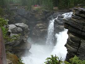
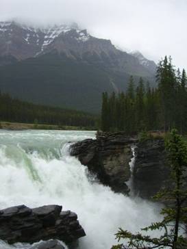
At Athabasca Falls on Icefields Parkway
TEASERS
Explore the history of Lake Louise Lodge Four days of glaciers, lakes, and rain Prices at The Crossing are as expensive as ever What would you pay to take a drive onto a glacier Imagine a huge river being squeezed into a small cliff crack Jasper, still the more laid back of Canadian Rocky Mountain towns
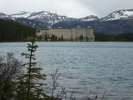
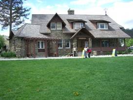
June 15 - Hob nob with the upper crust Back around 1885 the final spike of the Canadian Pacific Railway was pounded into place. Two years before that a man named Tom Wilson, an assistant in the surveying, was led to a beautiful turquoise colored lake high in a glacier cirque. He named it Emerald Lake because of its color. That name was later changed to Louise after the 4th daughter of Queen Victoria. Wilson eventually convinced the railroad to build a trail up to the lake. In 1882 a rustic 2 story lodge was built. This lodge burned to the ground. The buckets the staff used to provide water to the guests just weren’t enough to put out the fire. A far more elaborate lodge was constructed. This was when the railroads were catering to the very wealthy. Patrons would come out to the parks and basically spend the entire summer hiking, mountain climbing, hob nobbing in the lodges.
Lake Louise Chalet and the lake In July 1929 the older wing of the second lodge burned despite all the newer water infrastructure. They have pictures showing the guests sitting out on the lawn under their sun umbrellas watching the staff try to put out the fire. The newer wing survived and dinner was served on time that evening, complete with orchestra. A new wing was built matching the style of the remaining wing. Everything is done in a very fancy European style rather than the more rustic, National Park style previously used by the railroad. The lodge looked so European, in fact, it was often used for movie settings supposedly representing luxury hotels in the Swiss Alps. Today the lodge is owned by the Fairmont hotel group and it is very, very expensive. If you don’t get some sort of group or discount rate it’ll run you about $499/night. We’ll just settle for our $27.40 campsite. Lake Louise and the Fairmont hotel Out in front of the hotel sits the beautiful Lake Louise. The color of the water is due to the rock flour flowing down from the 6 glaciers that sit high on the mountain peaks behind the lake. In summer the lake turns this amazing turquoise color. We hear that in other seasons, when the glaciers aren’t melting so much, it turns a deeper blue. It all depends upon how much water is flowing down from those glaciers. There’s a wide, very flat trail that leads along one edge of the lake. People of all ages and abilities take strolls down this path. If you want, though, you can continue on the more rugged hiking trail up to the cirque of 6 glaciers. It’s a hike we’ve done twice and it’s well worth the effort. One time we had lunch at the tea house and sat on the patio watching pieces of the glaciers calve off and crash into the valley below. It’s one of our most memorable lunches. Unfortunately at this time the trail was not recommended due to snow levels. Avalanche danger the sign said. However, we did note a steady stream of helicopters obviously working on getting that tea house ready for the summer. Just imagine a summer job working at that tea house.
Since the weather was turning to rain once again, we didn’t wander too far. Besides we were supposed to be resting. Although walking about 5 miles for the day isn’t exactly like a total day off our feet.
June 16 - Blecky weather again Ah once again we woke to hear the relentless pitter-patter of rain drops on the tent. This song of rain is really getting old. So our decision was, do we ride on or do we stay another day. Over at the visitor center we read, reread, and reread the weather report. Our objective was to take 4 days to ride to Jasper. The main reason for this is we wanted to avoid camping at the Columbia Icefields this time. Even in the middle of hot summer weather this campground is cold. In cold rain it would be really uncomfortable. Studying the weather we noted there would be 2 days of rain and cold, 1 day of partly sunny, and then another day of rain. That settled it. We had to leave that day in order to ensure we’d be at the Icefields on the one, best day. So after waiting until the absolute last minute we headed out. We got lucky. It was only just drizzling. We were told that earlier in the day it had been pouring at our destination campground. We went just 17 miles which left a bit over 40 miles for each of the remaining 3 days.
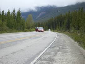
A bear tries to cross the road on the Icefields Parkway
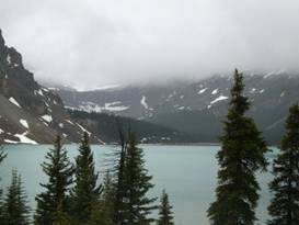
June 17 - Lakes and glaciers Getting set to leave was fun. It had drizzled all night long and was still at it when we were getting ready to leave. Fortunately the Canadian National Park campgrounds usually have a common use kitchen. We took over a table and gradually collected our wet equipment together and got everything packed up. It was a cold morning and would be a cold day. The Icefields parkway is one of the most dramatic roads in North America. From this road you can see one glacier after another along with several of those pretty blue lakes. That is if the mountains aren’t covered in clouds. Just north of Lake Louise the Continental Divide is lined with one large ice field after another. From each of these icefields, frozen rivers will reach toward the valleys below. Since the end of what is known as the “mini ice age” of the 1800s, these glaciers have been shrinking. Although they will eventually once again grow as the earth goes through it’s normal cooling and warming trends. Within just a few miles of camp we climbed up to Bow pass. Here you’ll find beautiful Bow Lake which has several glaciers hanging on the mountains over it. There’s a nice lodge on the lake that would be a wonderful place to spend the night, if you didn’t mind the price.
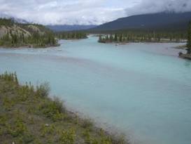
Lovely Bow Lake Another glacier you can see from the road is called Crowsfoot. It’s so named because it used to have 3 toes, one of which lies high on the ridge. Since its naming one of those toes has disappeared. Crowsfoot glacier overlook On the run down from Bow Lake we passed by Waterfowl Lake, another lovely viewpoint. Waterfowl Lake overlook The road soon makes a very steep descent to meet the Saskatchewan River. There’s a second entrance to the Icefields Parkway here via a road that runs out to Rocky Mountain House, AB.
The Saskatchewan River We flew down the steep hill while being pelted with stinging cold rain. It hurt so much we were having trouble seeing where we were going. We bypassed the canyon hike along the way. We’ve done it 3 times already. We flew pass the overlooks. We wanted to get into a warm building for a while. At the intersection is a place that’s been there forever, The Crossing. This is a motel, restaurant, gift shop, gas station, plus mini market. The only problem is its prices are out of this world. They were back in the early 90s when we first came through and they still are. For example $15 for just a hamburger and fries, no drink. The problem is it seems that every bus tour stops there for meal. So this place has a captive audience. The tourists on those busses eat here or they don’t eat. We’ve always managed to avoid buying anything more than just a little supplemental food, that’s it. Not too far up the
road we came to Rampart Creek Campground. At an elevation of around 3500 ft,
this would be significantly warmer for the night than the Columbia Icefields
Campground. We pulled in just when the skies were finally starting to turn
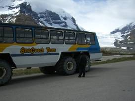
brighter. For once the weather report seemed to be accurate. Brewster’s is a company that has been a part of Banff and Jasper National Parks since forever. They have shuttle bus service that runs the length of the parkway plus from Banff and Jasper to the various airports. They run tour busses up and down the parkway. They provide charter tour bus service to the hotels and individual groups. Plus they run the famous snocoaches at Sunwapta pass. Athabasca glacier and the snocoaches
Brian with modern Brewsters Snocoach By the 1960s and 70s the number of people going up on the glacier had dramatically increased from that initial 1,000 persons per season. So they bought some old busses and added tracks to them. In addition they put in a very small, almost trailer like, sales office. Parks Canada also put in a small visitors center as well. We remember those two old buildings as that’s what was there when we made our very first visit. By 1995 the
attraction had grown so much that they had to build an entirely new structure.
It’s huge. There are queues for getting your tickets video monitors telling
you when your sno coach is about to leave, parking slots for the tour busses
that come in each day, a large gift shop, cafeteria, restaurant, and even a
motel. It’s become awfully Dizneyish nowadays. A little too polished for our
tastes. We miss those old ramshackle, adhoc buildings. But the need these
facilities to service their 5,000+ visitors per day. The glacier that the coaches take you on is called Athabsca and is one of many ice rivers that descend from the large Columbia ice field. This is the largest ice field in BC. They say that from it you can make trillions and trillions of ice cubes or fill billions and billions of bathtubs. You can take a ride on the snocoach, if you wish. Prices now run around $50 per person. Although at this off season they seemed to be having special deals for 3 or 4 people.
We’ll never forget the tale he told us of the one fellow who slipped into a sink hole, rode the water river under the glacier, and somehow, miraculously popped out at the bottom of the ice at the glacier’s toe. This glacier hiking expert never set foot on the ice again. The road getting up to Sunwapta pass and the icefields parkway is one of the most stunning we know. As you ride gradually uphill southward you encounter absolutely shear cliffs to the east. Black streaks coming from the lip of the cliff indicate where waterfalls might exist. Actually, in a downpour this entire cliff will have thousands of small and large waterfalls pouring down the side. There’s one small section where this occurs constantly giving this wall its name, Weeping Wall.
A climbers’ Mecca, the weeping wall
A bit further on, after a steep climb to a bridge over Nigel River, the road makes a 180 degree flat loop. Catch your breath here as there’s still much more climbing to go.
Nigel Creek going under the road in a nice cascade
Another steep climb in the opposite direction brings us to an overlook of the road we’d just passed and a top view of the Weeping Wall. The wall looks so tall from below. But from this height you can see that it’s only a small part of the total mountain. From the crest of the cliff the mountains continue up at least as much but at a shallower slope. This time of year there can be a lot of snow on that slope.
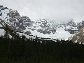
Valley just south of Sunwapta Pass One final grunt and we’re at last at the broad alpine valley just to the south of Sunwapta pass. In this valley you get your first glimpses of some of the glaciers descending from the very large Columbia Icefields. There’s a nice ridge trail up there that we’ve always wanted to do. But either we were hurrying to grab a campsite at the Columbia Icefields campground or there was too much snow. Once again, there was too much snow.
It was cold at this altitude and we were going through periods of pelting cold rain. We stopped for a few photos of this chilly scenery and headed on down to the warmth of the visitor’s center.
Very snowy valley before Sunwapta pass
The Icefields visitor center was built almost directly on the terminal moraine from the largest historically known expansion of the Athabasca Glacier. Photos takes in the 1840s show just how much further the glacier reached. Now it has receded by about 1.5 km. You can take a walk up to the toe of the glacier if you wish and look at placards that show where the glacier toe was at specific years. We didn’t do it this time as we have 3 times before. But we did eat lunch and enjoy the views from the visitor center’s porch. The view
from the icefields center porch
Rain was once again in the forecast for the night and all day Sunday. The campground at the icefield is cold even on the warmest July and August days. To stay here with a freezing rain coming down just was not appealing at all. So we hustled on down hoping to make it to the Honeymoon Lake campground. Unfortunately we were bucking a strong headwind the entire way. So upon reaching just Jonas Creek we called it quits for the night.
June 19 - Waterfalls and more rain Sunday was supposed to be another rainy day. So what else is new. We got ourselves up early and got going with the hope of reaching Jasper and getting settled in while it was still somewhat dry. The mountains were covered in a shroud of fog and clouds. So apart from the rolling green valley hills and an occasional peak at the rugged ridges, the views weren’t what we’d been hoping for. At pullouts there are wooden arrow signs pointing out this mountain and that mountain. But all were covered in clouds.
Upper part of Athabasca Falls One attraction that isn’t high and not covered in clouds is the Athabasca falls.
One side of Athabasca falls
The glaciers created a step in the valley. Water, being lazy and always taking the easiest path, found a crack in the step cliff.
The other side of Athabasca falls
Over time the water widened the crack. The face of the water falls moves ever slowly upriver as large chunks of the cliff wall break away. The result is a massive tumult of water from the wide Athabasca river being squeezed into a narrow slot in the cliff face. It makes for quite a sight, one that every tour bus stops at. Athabasca
falls is moving, slowly
From the falls we only had about an hour or so to go. But it seemed the nearer to Jasper we got, the worse the rain. By the time we approached the campground we were soaked. Even our newly acquired rain shoe covers were starting to soak through. So we spent 4 days on the Icefields parkway and we had at least some rain every day. I suppose having ridden this parkway 4 times now and 3 out of 4 were in superb weather our luck still isn’t all that bad. June 19 - Jasper
The vast majority of visitors who come to see the Canadian Rockies fly into Calgary and drive right up to Banff. Banff is probably the most famous of all the Canadian Rocky mountain towns. Hence it’s filled with all sorts of tourist style stores, restaurant, hotels, etc. This is the main place for all those bus tours to descend upon.
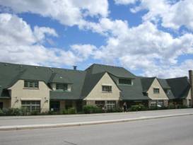
The meeting place, Jasper’s historic visitor center Jasper is Banff’s lesser known little sister. It’s smaller that Banff and far more low key. It is here that the backpackers gather in summer over the lawn around the historic visitor center. They’ll spend the sunny afternoons bragging about hikes and climbs taken and making plans for the next adventure. We’ve visited Jasper several times over the last 20 years and despite all those years those backpackers always look the same. There are some things that never change. A look around Jasper As time goes on it seems Jasper is becoming more and more like Banff. It’s becoming Banffized. Since our first visit so many years ago it seems it has gotten more tourist stores, more fancy hotels, and more restaurants. Some were quite a surprise. The new KFC, Pizza Hut, and A&W were definitely not there last time. There’s also a much bigger supermarket as well. The main area of interest for tourists lies along the 2 parallel streets just in front of the old train station, Connaught and Patricia. The train station is a beautifully restored structure. It’s exterior was designed to mimic the mountains which stand dutifully as its backdrop. The lower portion of the building is covered in rounded river rocks, very much in the Arts and Crafts movement so popular back then.
Jasper’s lovely old train station
Outside the train station at Jasper
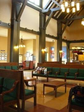
The interior is just as lovely with exposed wood beams accenting a mellow, off yellowish wall coloring. Even the original wood waiting benches are still in great shape. This still is a functioning train station. Twice daily visitors unload for a 1 1/2 hour stopover, just enough time to buy a trinket or two from the tourist shops.
Inside the lovingly restored train station s
Inside the train station at Jasper
In front of the train station and a bit to the east is that famous gathering spot, the visitor center. These two buildings were the largest and most grandious structures in town for a long time. When new construction was added, it was usually done in a style that matched these. This gives the entire town a very uniform appearance The setting is gorgeous. The town quaint and relaxed. If you’re finishing a tour you can’t pick a better spot.
APPENDIX A – ROUTE
June 16 - Icefields Parkway to Mosquito Creek Campground, 16.90 miles June 17 - Icefields Parkway to Rampart Creek Campground, 41.74 miles June 18 - Icefields Parkway to Jonas Creek Campground, 40.15 miles June 19 Icefields Parkway to Jasper, 47.34 miles
APPENDIX B – CAMPSITES, HOTELS
Currencies listed in Canadian dollars, exchange about $1.025 USD = $1 CND
June 15 - Lake Louise Campground ($27.40) June 16 - Mosquito Creek Campground, ($15.70) June 17 - Rampart Creek Campground, ($15.70) June 18 - Jonas Creek Campground, ($15.70) June 19, 20 - Whistlers CG in Jasper ($22.50/night)
REFERENCES
Adventure Cycling Association Great Parks North Route Section 2
|
|
Copyright © 1995-2011 by Caryl L. Bergeron - Distribution for personal use permitted. Distribution for other uses with written permission.
Acknowledgements
|