April 15, 16, 17, 18 - Iquique
to Arica
Odds are a zillion to one that we
will ever return to this most northern region of Chile. We just don't have
that much desire to spend more time in this desert. Yet, the only part
we'd been able to explore was the coast. It was a nice ride with spectacular
scenery and all. But, we did feel we missed a bit by not seeing some of
the inland regions. We had absolutely zero desire to do it on bike. The
only option that made any sense was to rent a car and Iquique was the ideal
place to do just that.
Renting a car for five days certainly
would give us plenty of time to visit some of the more remote places of
Region I. But, time was running short. We spent hours pouring over maps,
checking distances, looking at our schedule, all trying to determine whether
or not we could afford the few extra days. Otherwise we'd hop a bus directly
to Arica, spend one day getting supplies, and then start riding, a time
of two days. If we rented a car for 5 days, how could we make up those
extra 3 days. As it was we figured we'd just barely have enough time to
ride to Cusco from Arica. There'd be no opportunity to ride on to Lima,
at least not for this trip
So after much deliberation we came
up with an idea, an idea that would work only if the rental car agency
was agreeable. We would take everything directly up to the town of Putre,
leave it there, and have the rental car agency either pick up the car there
or drive us up after picking up the car in Arica. Putre is a tiny town
located 127 km east of the Panamericana highway and about 12,000 ft above
sea level. Originally we figured a full 3 days riding to get there. A ride
that would be right across some of the worst section of dry desert. By
getting up to Putre with the car we'd save those 3 days and all that climbing.
We'd also be able to take a whole bunch of supplies with us, supplies that
would be difficult to find further east. This seemed to be the ideal option
for allowing us to do a bit more exploring and getting us back on schedule.
And as it turned out, the rental car agency was all too happy to assist.
I'd have to say that Nippon car rental in Iquique has to be the best
Early on Monday morning, after taking
a quick tour of Iquique's well arranged regional museum, we picked up the
car. Our plans were to tour a couple of the old, abandoned nitrate oficinas,
see some geoglyphs, and then head straight for San Pedro de Atacama down
in Region II. Everything we'd heard said this was quite a place to visit.
Since we had to skip it further south, we though this would be our one
opportunity to see it
All best laid plans don't always
work out. It was just about 6:30 at night when we rolled up to the inspection
station between Regions I and II. After climbing out of the car I asked
the woman what she needed to see. She mentioned some sort of pass for the
car. We pulled out everything we'd been given. She asked for more. We had
no idea what else she could possibly want. Finally we called over her boss.
It took some time, but he calmly explained that since this was a "zona
franca" (duty free zone) car we would not be allowed to take it out of
Region I for any reason without some special form from the rental car agency.
We were dumbfounded. To us this would be like renting a car in Texas and
then being told at the New Mexico border that we couldn't cross the state
line without special paperwork. We tried to explain that we just wanted
to go up to San Pedro and we'd be bringing the car right back. That didn't
work. He couldn't let us go. We were frustrated
Yet we couldn't blame the rental
agency. We hadn't given them any indication that we were planning to head
to Region II. It certainly wasn't our fault. This whole "zona franca" concept
and it's ensuing rules and restrictions are something we'd never encountered
before. It never occurred to us that taking the car into another region
would be a problem. It wasn't as though we were going into Peru. And we
couldn't blame the official. He was just doing his job. If he made an exception
for us he could get into real trouble. Flipping through our two guide books
we found the problem. Neither mentions problems with taking a rental car
out of a zona franca. One mentions there are difficulties taking a car
you bought out, but there's nada on rental cars. It's their fault. We had
no other choice but to turn around and come up with plan B.Exploring for a few days in a car
gave us so much opportunity to see so many things that otherwise we would
have missed. The old oficinas were incredibly fascinating. Right next to
the scruffy town of Pozo Almonte, a current nitrate plant and highway support
town, sits the remains of two large former nitrate oficinas. The biggest
and best preserved is Humberstone. Oficina La Paloma, as it was originally
known, opened in 1872 and continued operation until 1960 when the economic
realities of the modern nitrate business forced it to close. It was renamed
in 1925 to honor James Humberstone, the oficina's manager from 1875 to
1925. At its height it employed thousands of people, providing housing
and board for them and their families.
Working for the nitrate mines prior
to the incursion of labor unions would have been much like slave labor.
Workers were paid in tokens, or fichas as they were called, rather than
negotiable currency. Tokens were valid for purchases at company stores
only. They had absolutely no value at any other town or even any other
oficina. Imagine working your whole life at this one company and at the
end of your career having a pile of completely worthless tokens. You worked
6 days a week with very long hours. Sick leave and vacations were unheard
of. Those were pretty much post W.W.II inventions. As you can imagine labor
unions made their first inroads into Chile among the nitrate mine workers
Humberstone today is a wonderful
place to explore. It's layout is fairly typical of the larger nitrate oficinas.
Half the community was laid out in rectangular residential areas and the
other half was dedicated to the more messy and haphazard arrangement of
nitrate processing plant. The houses were all neat rows of small one story
apartments laid out in a rectangular array around the green central plaza.
Each white stucco apartment block had about 5 dwellings. An apartment usually
consisted of a covered porch, 2 to 5 rooms arranged in an irregular pattern
around a central, inside courtyard. I assume the more senior your position
at the plant, the better your house. Around the central plaza was the company
store, an interesting looking 1940s style building with front windows still
intact complete with left over merchandise, the huge theater, a 1930s addition,
a hotel, and the church. Behind the hotel was a large swimming pool made
from the cast iron remains of a shipwreck from Iquique
Over in the factory side of the
compound we found an antique machine enthusiast's paradise. There are two
huge machine shops where many of the old large machines were simply left
in place. Every imaginable machine is lined up along the shop floor and
all were belt driven. Little stuff, nuts, bolts, small tools, etc. had
long since been taken away for salvage. In another building stands the
generator. One set of the huge cylinders had been removed leaving only
the cradle for the camshaft behind. However, one of the three cylinder
generators was completely intact, never to run again. Out back were remains
of the small rail that serviced the plant. There was almost an entire engine,
steam driven of course, as well as bits and pieces of tank type cars, and
an old rail mounted crane. The old buildings housing the left-over machines
were all covered with corrugated metal. In the wind, everything rattled
and banged with that abandoned metal shed sound. A large, black smoke stack
is the central focus of the entire site. Despite the dry climate, rust
coats everything. With the reddish colored dirt and the rust colored buildings,
everything has an eerie red tone. We wondered about all those machines.
If you really had the calling to create an antique machine shop, this may
just be the place to find your equipment
Not far from Humberstone is a second
nitrate plant, Santa Laura. Most of this ex-oficina has been torn down.
Virtually none of the houses remain. Santa Laura has a different type of
processing, more vertical. At the bottom of a long, conveyor belt ramp
sits the former mills where the first grinding took place. Half way up
the ramp a second, finer mill sits. Finally up top everything is dumped
into large vats where heat is used to remove impurities leaving high quality
nitrates. The building is now a wrecked hull on which huge, rusted tanks
now precariously sit. Signs warn visitors of potential collapses. It's
not a good idea to climb up on the structure
Nitrates were used for a wide variety
of purposes including fertilizer, glass, explosives, and iodine. Most of
these uses have found newer, manmade replacements. Yet, some nitrate production
still remains. As you look out across the rusty relics of Humberstone and
Santa Laura you can see the gleaming white and blue boxes of the brand
new iodine, yodo in Spanish, plant. Large swaths of sparkling white nitrates
sit drying in the blistering noonday sun. The contrast of the new versus
the old is quite startling. There may not be 350 oficinas and big nitrate
barons anymore. But, their legacy lives on
An even more amazing legacy was
left behind by the earliest inhabitants, the coastal Indians. As a stable
civilization based on agriculture developed both in the altiplano and coastal
regions, a vibrant trade was established. This trade really began to flourish
during the Tiwanaku era, a civilization that died out about 200 years before
the Incas came to reign. Running up and down most of the deep quebradas,
canyons, that reach far into the inland regions, caravans of llamas hauled
goods back and forth. Llamas were the only beast-of-burden available to
the new world inhabitants and they weren't a very efficient one at that.
Llamas can only carry 20 kg on their backs and do not pull carts. As a
way of marking the different trade routes these early merchants build huge
sign posts. Geoglyphs of monumental size abound throughout this region
of Chile
Unlike pictographs, which are paintings
on rock, or pectoglyphs, which are pecked out designs on rocks, geoglyphs
are enormous rock designs made by literally moving or scraping large amounts
of surface rock into positions that leave a mammoth design behind. Sometimes
surface rocks are scraped away making for a lighter design with a dark
background. Other times the darker rocks are piled up over a lighter surface.
Sometimes the designs had religious significance. However, due to the nature
of these designs, archaeologists believe that these Chilean geoglyphs are
intended to show trade routes. Usually there are representations of llama,
lots and lots of llama. Often there is a herder leading a string of llamas.
Many times there are unusual geometric symbols that seem unique to each
particular trade route. Sort of a Route 66 sign of today. There are other
symbols, not related to llamas; reptiles, birds, fish, other humans, and
lots of other geometric symbols
Fortunately, Chile has done an excellent
job of preserving, restoring, and marking many of these old geoglyphs,
which is nice for us tourists. At a place called Pintados you can see a
wide array of geoglyphs along a 4 km stretch of rough dirt road. This happens
to be the only site that charges an entry fee. Another interesting geoglyph
is called the El Gigante de Atacama. This is a huge geoglyph representation
of a human located on a small knoll of a hill just east of the Panamericana.
At 96 meters in height, it is reputed to be the largest archeological representation
of a human in the world. It's an odd, blocky shaped figure having 12 lines
extending from its head, four top and four on each side. One hand looks
like an arrow. It seems to us that it could well represent a shaman or
other important person. Other geoglyph sites are scattered all along the
highway between Iquique and Arica
Even though the Atacama is dry as
a bone, there are a few oases scattered about. In some places water from
high in the Andes somehow reaches to the sea or percolates up in specific
spots as thermal or regular springs. The small resort town of Pica is one
such spot. Due to its dry, sunny climate and reasonably abundant underground
water, Pica is a great place to grow citrus and mangos. It also has several
pools with small resort style hotels and cabanas. In the nitrate boom times
this was a place where the rich and powerful would go to escape summer
heat. A town has actually existed on this spot since 1535 and its unusual
baroque style church dates from the 1700s. As you approach Pica and the
nearby smaller town of Matilla it is so strange to see this clump of greenery
surrounded by tan sand. It seems even stranger to stand in the middle of
its pretty, flower filled, tree shaded plaza to realize that just outside
the town limits is nothing but sand.
Another strange occurrence in the
desert is the forest. Yes there is actually a forest of a native tree called
the Tamanugo. Actually, they look more like large, feathery bushes with
a dusty green leaf. The forest today is not the original as the first trees
were nearly obliterated to provide fuel wood for the nitrate plants. These
new trees were replanted by the Chilean national park service, CONAF. You
can tell they're planted by the nice, uniform rows. CONAF hasn't quite
figured out that a natural forest knows no regularity. These remarkable
trees require irrigation for only a few months, during their early sprouting.
Then their tap roots quickly reach several meters down to hit the subterranean
water. Unfortunately, water thirsty Iquique has lowered the water table
which has lead to the death of many of these trees. It's rather depressing
to cruise along the highway seeing large stands of dead trees. We wondered
if there would eventually be some remedy to this problem.
As the Panamericana heads north
from Iquique toward Arica it passes through four remarkable canyons. These
are extremely deep canyons, one probably being a good 5,000 feet deep.
At least the road took about 20 to 30 km to climb out along a good 6 to
8% grade. Above these canyons is nothing but the usual lifeless brown.
At the bottom of these canyons, on the other hand, is an amazing lush river
valley. Water, a small stream, flows in each. There are farms in the canyons
where they grow corn, chickens, and other produce. Seeing each of these
forms of oases within this desert really does give one a strong impression
of just how fertile the desert could be if only it had water.
Our adventure in the car also included
a quick trip from the high mountain park of Parque Vulcan Isluga, over
4,000 meters elevation, all the way to the seaside fishing village of Pisagua.
Roads leading into the high mountains are remarkable feats of Chilean determination.
These are not easy mountains to cross and any road, once built, seems to
deteriorate rapidly. Getting to the top requires paying careful attention
lest you careen right into a car swallowing pothole. The further up you
get the more spectacular the scenery becomes. The hills become green, not
with trees as there are no mountain pines in South America. Instead there
are low shrubs similar to what the US has in the desert southwest. Ground
water reappears in the form of numerous streams and large bogs. Alpaca
and llama, raised by the local Aymara natives, graze everywhere. If you
try to sneak up on a group of llama for a close-up photo you'll get nothing
but a shot of their rumps. As compared to the desert, the high Andes are
far more exciting.
After a long afternoon drive, we
arrived at the intersection to the park well after dark. From there we
headed down a bumpy, washboard road to the center of the park and the camping
which overlooks a lukewarm thermal bath. Along the way we passed the nearly
deserted town of Isluga. It's buildings are mostly tan colored adobe with
thatched roofs, those having roofs at least had thatching. In the middle
of town is a brilliant white washed church. Nothing appeared to be moving
in this dark town. Despite having electric lights, there was no electricity
at this time of night. Virtually every door we passed was closed and most
were padlocked. Except one. As we passed we caught a glimpse of an elderly
man and woman standing next to a fire. Both were dressed in traditional
costume. Our glimpse was so brief I was reminded of one of those life-size
displays in a museum. The next day, in full light, we saw many more folks
dressed in the traditional way, but none had quite the same impact as this
brief view.
From the high mountains, down to
the sea took virtually most of the day to complete. We arrived in Pisagua
with barely enough time to cook and set up the tent. The following day
we looked around. Pisagua is another of those former nitrate ports that
now is nothing more than a tiny fishing village of 200 people. The grand
theater with an impressive facade, the large rail station, the big pink
and white stone hotel, and the large remains of an old fish processing
plant give evidence to Pisagua's earlier, busier times. Apart from the
few fishermen, the navy also has a nice little station. They have 4 small
boats that they take out into the harbor every day to run training exercises.
We're not sure what they were doing. They'd come together at a point, then
face different directions and steam away, turn and come back to the same
point again. It looked like toy war games. One thing you will notice if
you, Joe tourist, drive through this town is that everyone, absolutely
everyone, will take note of your passage. It's a nice, picturesque town
that I am absolutely sure no bike tourist has ever visited. At 41 km off
the main route, a long climb out, and only one way in or out, I doubt any
biker would ever take the side trip.
Having finished exploring almost
every part of Region I there was to explore, we finally headed to Arica,
Chile's most northern city, to prepare for our climb to Bolivia.
Tis a far, far faster way to
get up that hill.
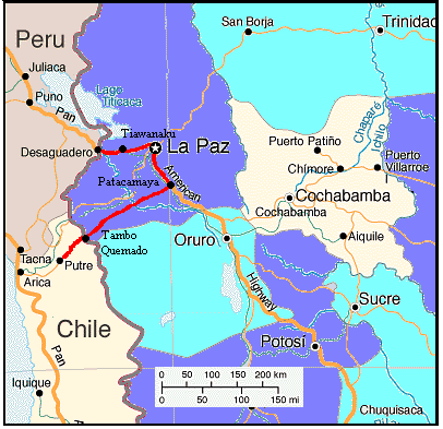
April 19, 20, 21 - Arica to Putre
With only about 5 weeks remaining
and still a long way to go to get to Cuzco, we needed to get up to the
town of Putre quickly. Riding that section up the hills, through the desert
was not something we particularly wanted to do either. Fortunately, we
had made arrangements with the rental car agency owner, Jaime, to get dropped
off in Putre. At an elevation of 3600 meters and 145 km further east, this
would save us a full 3 days riding time. However, first we had to get the
bikes up to Putre. There simply wasn't enough room in that car for three
people, two bikes, and loads of gear. So after doing a few errands in Arica,
we hopped in the car for the long 5 hour drive up the mountain and back
down. Well, at least we did get to see this climb twice, enough to convince
us that taking the car was definitely the way to go. Riding from Putre
to Arica would be easy. The other way would be nothing but a long, hot,
waterless trudge through barren scenery.
Arica is another of those duty free
ports similar to Iquique. However, it hasn't quite caught on as a big tourist
destination. It doesn't seem nearly as wealthy. It lacks the fancy shopping
mall of wealthier Iquique and Antofagasta, there are few high-rise expensive
hotels and condominiums, and the ramshackle neighborhoods seem more extensive.
From a tourist standpoint, there isn't a whole lot in Arica to see or do.
There is one big hill to climb which gives an overview of the city, an
aduana building designed by Eiffel, and a supposedly very good museum out
in the Azapa valley to the east of town. As it turned out, with the time
needed to get the bikes up to Putre and all the other tasks we had to do,
we didn't even get to visit these few very limited sights. Oh well, it
was worth it just to be able to get up to Putre easily, quickly, and with
a large supply of food brought from Arica.
Now Putre, on the other hand, is
a very nice place to spend a few days acclimatizing to the altitude. It's
located on a flat ledge that seems to be the extension of a fine green
valley. There's substantial farming on the flat regions and on some of
the expansive pre-incan terraces that extend down the ledge. The town's
population is around 3,000, although I'm not sure whether this includes
the members of the military housed on the western edge of town. Buildings
are mostly single story adobe structures with metal or thatch roofs and
are laid out in the typical rectangular pattern around the plaza. The usual
town plaza is a very small affair with two levels and little shade. There's
the white adobe church dating from the 1600s when Putre was a Spanish reduccion,
three little stores, a bank, phone center, and several small hostals and
restaurants. Restaurants serve up hearty meals that are far more spicy
than anything we've found in Chile so far. Tour groups visiting the nearby
Parque Nacional Lauca spend their nights in town. Bike tourists form both
directions would find this an ideal place to rest and resupply despite
the long, hilly 4 km entrance road.
It's so hard to breath so high
up
April 22, 23, 24, - Putre, Chile
to Bolivian border
We'd been in Putre for over 48 hours.
No nausea, only slight headaches, and lots of heavy breathing. So surely
we must be ready to tackle the climb. Then again... Putre is at a nice, thin air elevation
of 3470 m, that's close to 12,000 ft. The highest elevation we've ever
ridden was just over 12,000 ft. In Guatemala we passed over one 12,000+
ft pass by pushing the bikes up the last little bit, much to the shear
delight and amusement of the local machete wielding farmers. In Colorado
while on the GDMBR we'd manage to ride up and over a 12,000+ ft pass, no
problem. So now here we were coming straight from sea level and, after
only 2 days at altitude, were preparing to ride up to a staggering 4660
m, over 15,000 ft. We had no idea how we'd respond.
Leaving Putre late in the afternoon,
I wondered whether waiting an extra day might not have been a wise idea.
Every little hill was a real huffer. We'd puff up about 1/2 km, stop to
catch our breath, and then puff up another 1/2 km. We gulped air as hard
as we could and still felt as though someone was standing on our chests.
It took a good hour just to make it the mere 4 km from town to the intersection.
Then the climb really begins.
The intersection for the side road
headed to Putre is only 90 m above the town center. Yet, it's up and down
several hills just to get to this point. From here as the road continues
east it climbs at a nearly constant 7% grade for the next 14 km or so.
Within this 14 km the road climbs a good 900 m. At sea level, no problem.
But, when starting out this climb at 3500 m this could be real difficult.
Information we gained from the Internet seemed to say that to avoid altitude
sickness it's best to climb no more than about 300 to 400 m per day after
reaching the height of 3000 m. This meant that we would have stop just
about 8 km into the climb, a whopping 12 km for the whole day. It turned
out to be a good idea anyway as we were really struggling just to make
it up this small amount. Fortunately, while in the car we scoped out a
good campsite located right next to a clean flowing creek just within the
altitude range we wanted.
From our first campsite we looked
up to a couple of nasty switchback turns up a tough climb past a small
military camp. I gaped at amazement to see a physical fitness course across
the street. Here we were gasping for breath about every 1/2 km and these
guys would be out here doing chin-ups. Of course, I suppose they give them
a few days to acclimatize before putting them to this endurance test. The
soldiers on guard duty said not a word as we passed. They just stared. We made a whopping 28 km and another
450 m climb our second day. We were improving, slowly. Just about at the
top of the steepest section of climb and at a small descent is an enormous
overlook. It's constructed of a rock paved floor and wall with many nice
wood benches scattered along the wall. In front was an unusual and very
out-of-place sculpture. It looks like a huge yellow Andean panpipe sitting
atop orange stairs and leaning against a blue cylinder. We discovered that
the area just underneath the orange stairs makes for one very sheltered
campsite. This mirador seems to us to be far too big. It's the size of
miradors one would find in Yellowstone National Park. Yet this mirador
would probably see at most 10 visitors in a day. Someone appears to have
had extra cash sitting around one day and decided to build this monstrosity.
Maybe they figured "build it and they will come." I don't think so.
Our distance was gradually increasing
and our huffing and puffing was growing not quite so heavy. We made it
to the incredible Lago Chungara in early afternoon with plenty of time
to wander around the lake and cook dinner before sunset. Lago Chungara
is one of the most spectacular lakes we've ever seen and the campsite we
had next to it was one of those most memorable that we've stacked up over
the years. It's a shallow, saline lake that is a favorite for an incredible
amount of birds. There are big gulls, coots, pink flamingos, and some cute
little birds that look more like floating billiard balls than birds. Around
the lake, vicuna nibble on the rich grasses growing in the clean stream
passing by the park refugio. We found little gray birds with bright yellow
bellies anxiously waited for us to finish dinner so they could clean up
afterward. Reflected in the water of the lake was the snowy peak of the
nearby volcano. It was all quite breathtaking, literally as well as figuratively.
We could have ridden on to Tambo Quemado in Bolivia, but we're so glad
we'd decided to stay.
A mere 7 km from the camping we
came to the Chilean border control where, after 20 minutes waiting in line,
we checked out for the last time this journey. From there we had an easy
ride up a few hundred meters to find ourselves in Bolivia for the first
time.
Welcome to Bolivia
Our first impression of Bolivia
was entirely mixed. The road was amazing. It's a brand new, paved road
having nice wide shoulders. It was even far better than the Chilean road
we'd just left. On the other hand, there was trash, trash, trash. We weren't
sure whether this was litter left behind by the road construction crew
or just stuff dropped out of bus and truck windows. No matter which, it
was still a shock. Fortunately we soon discovered that this large amount
of trash was pretty much relegated to the border area. The further we got
from there the less trash we found
The other item that we found most
unique were the llama and alpaca. They roam all over the hills. Thousands
of llama and alpaca. They're as common as cattle is in the U.S. west. They're
rather cute, at least the alpaca are. The llama aren't quite as good looking.
Most have colored strings tied to their ears and back fur. They're very,
very furry and come in colors ranging from white, light brown, dark brown,
and almost black. As we passed by we had to wonder how the ranchers ever
manage to round up their herd when it comes time to send them to the butcher.
Later we discovered, it's all on foot. They have no horses, no ATVs. Usually
someone stays out with the herd all day keeping it together and out of
trouble. There's no such thing as a once a year "round-up".
Finally we approached the border
town of Tambo Quemado. From a distance it looks like a fairly reasonable
town. On close up inspection, its state of disrepair and chaos is quite
evident especially when compared to the far more orderly Chilean towns.
The border post is something right out of a third world movie set, a somewhat
dilapidated building made of red brick. Women wearing the traditional dress
sit out front on the steps. They're the money changers. Men selling some
sort of drink in glasses stand in the middle of the lanes. We chose to
skip that. After filling out a form we received our stamps, with the correct
date, and were in Bolivia officially. Thankfully we had absolutely no hassles
whatsoever.
Tambo Quemado, the town proper,
sits about 50 feet off the main highway across a dirt parking lot. There
is a row of brick buildings some of which are stucco and painted in colors
of blue, pink, white, or yellow. Others are just brick. Many are only half
finished. There are basic hotels, small restaurants, and very tiny stores.
Electricity is minimal. So finding anything that needs to be cold, such
as ice cream, is impossible. After walking from shop to shop I finally
managed to find a small amount of fresh cheese for lunch. That was more
than enough of the border town for us. It was time to head into Bolivia
proper.
Bolivia has a long, rich, and often
tumultuous history. Around 900 BC, long before the arrival of the Spanish
and Inca, a large civilization evolved in the Andean altiplano with its
base located at a religious site on the southern shore of lake Titicaca.
These people, called the Tiwanakato, reigned from the shores of the Pacific
to the eastern tropical valleys. Tiwanaku grew their civilization by settling
rather than by conquering neighboring regions. The reign of the Tiwanaku
came to an abrupt end around 1200 AD.
After the fall of the Tiwanaku three
groups dominated the high Andes; the Uru, a small group that predated the
Tiwanaku, the Amyara, and the Quechua, better known as the Inca. The Inca
moved into the region in the 15th century. They called the Bolivian highlands
the Kollasuyo, one of four of their administrative units in which the highest
official answered directly to the Incan emperor. Using a system called
"mita" the Amyara were forced to work in the Inca mines, serve in their
military, farm the Incan lands, and build Inca structures. The Inca fully
reimbursed the Amyara for all labors given in mita. It was part of their
philosophy for responsible leadership.
Francisco Pizarro, Diego de Almagro,
and Hernando de Luque arrived on the Peruvian coast in 1532. Following
the death of the Incan leader, Huayna Capac, in 1527, his sons, Huascar
and Athualpa, fought for control. Athualpa, having won the war, but not
consolidated his power, was a much weakened leader. He made major tactical
errors including failing to recognize that the Spanish did not fight in
the traditional ceremonial manner. Upon meeting it took little provocation
for the Spaniards to fire on the warriors and take Athualpa prisoner. Even
after receiving a king's ransom in silver and gold, the Spaniards executed
the emperor. Cusco fell just one year later. Native rebellions continued
throughout the colonial period but after the public beheading of the leader
Tupac Amaru in 1572 most revolts were localized.
Almost immediately civil war broke
out when Pizarro and Almargo began fighting each other. In 1537 Almargo
took Cusco. Pizarro defeated and executed him in 1538. Then Almargo's supporters
assassinated Pizarro. Finally, Gonzalo Pizarro, Fransisco's brother, took
control and started fighting with Spain. Gonzalo was executed in 1548 after
which Spain finally gained control of the rebellious Spaniards. The city
of La Paz was established in that year.
Spain quickly recognizeed the value
of the altiplano's mineral deposits. The western world's richest veins
of silver were found around Potosi. Yet, output was sporadic throughout
the colonial period. Easily reached surface deposits were quickly exhausted.
As they needed to dig deeper, the available native labor decreased due
to disease and over exploitation. Mercury refining and hydraulic mining
were important technological advancements. Yet even these would not stem
the tide. By the beginning of the 19th century the mining economy of Potosi
had collapsed.
Spain's long hold on the colonies
was due primarily to policies aimed at extracting revenue and labor from
the natives. First there was the Viceroyality of Peru joined with the Viceroyality
of Rio de la Plata centered in Buenos Aires. The viceroy was aided by audencias,
one of which was in Chuquisaca (Sucre today). To increase revenues and
reduce abuses, Spain switched to an intendency system in the 18th century.
Then local officials came under direct Spanish control. There were four
intendencies in the Altipano; La Paz, Potosi, Chuquisaca, and Cochabamba.
Under this system, Corregidores de indios collected taxes and imported
goods that the natives were forced to buy, a practice widely abused. Discontent
lead to the great rebellion of Tupac Amaru II, AKA Jose Gabriel Condorcanqui,
in 1780, another revolt by Thomas Catari in Potosi that same year, and
a continuation of the revolt by a cleric taking the name Tupac Catari.
He was defeated and executed in 1783 which marked the final end of Indian
rebellions.
Discontent with Spanish rule also
grew among the criollos. On July 16, 1809, Pedro Domingo Murillo lead a
revolt in La Paz and proclaimed independence. By November, Cochabamba,
Oruro, and Potosi had joined. For years thereafter Bolivia was the battleground
between Peruvian royalists and Argentine rebels. In the Battle of Ayaucucho,
General Antonio Jose de Sucre Alcala defeated the Spanish. Another third
element under a General Olaneta was defeated on April 1, 1825 which effectively
ended the war for independence. On August 6, 1825 a Bolivian assembly voted
to become a nation independent from Argentina and Peru. Five days later
they named their country Bolivia after the war hero General Simon Bolivar.
August 8, 1825 Bolivar rode into La Paz and took the presidency of the
new nation.
Sucre succeded Bolivar in 1826 and
resigned in 1828 after an assassination attempt. Then Andres de Santa Cruz
y Calahumana (1829-39) presided over a relatively stable economic, political,
and social order. His downfall was in forming a confederation with Peru
to which Argentina and Chile objected. Santa Cruz's defeat to Chile at
Yungay in 1839 resulted in the breakup of his confederation and the end
of his career.
For the next 40 years Bolivia was
governed by a series of corrupt presidents while its economy stagnated
and seemed to rely entirely on taxes collected from the indigenous people.
They had General Franco (1839 - 41), General Ballivian (1841 - 47), General
Manuel Belzu (1848 - 55) whose main claim to fame was his ability to withstand
42 coup attempts, and Belzu's son-in-law General Cordova (1855-57).
Jose Maria Lizarazu (1857 - 61)
overthrew Cordova and became Bolivia's first civilian president. He encouraged
free trade and foreign investment. Mining production increased mainly because
of technological innovations, i.e. steam engines, and the discovery of
huge nitrate deposits in the Atacama. Agriculture continued to stymie and
the tax burden on campesinos was still large.
So much for civilian rule. Lizarazu
was overthrown by military coup in 1861 beginning one of Bolivia's most
violent periods. General Jose Maria Acha Valient (1861-64) murdered 71
Belzu supporters. Next, despite mismanagement, drunkenness, and corruption,
General Mariano Melgareho Valencia (1864-71) hung on to control through
severe repression. He ceded 102,400 sq. km. to Brazil in hopes to gain
ocean access and he grabbed Indian owned land by requiring them to pay
large sums of money within 60 days, which most couldn't. In 1871 he was
overthrown and later murdered in Lima. Augstin Morales Hernandez (1871-72)
continued in Melagarejo's style and was assassinated. Two more presidents
Ametller (1872-73) and Ballivian (1873-74) came and went in quick succesion.
Finally, Hillarion Daza Groselle (1876-79) seized power to become just
another ruthless military leader.
Daza lead the country into the disastrous
War of the Pacific. Briefly, Bolivia imposed taxes on the nitrate extraction
of the Atacama, a region that was supposed to be shared by both Chile and
Bolivia. Chile protested and sent in troops. Bolivia joined Peru and both
lost. The outcome was that Peru was shortened up to the town of Tacna and
Bolivia lost all their coastal access. Daza fled to Europe taking most
of the Bolivian treasury with him.
Following the war true political
parties started to emerge. Conservatives wanted to reach a quick peace
with Chile and negotiate for building a railroad to the ports for mining
exports. Liberals wanted to attract U.S. investment. Both parties wanted
political and economic modernization. They reorganized, reequipped, and
professionalized the military while trying to bring it under civilian control.
The decades from 1880 to 1920 saw Bolivia's first relative political stability
and prosperity.
Conservatives ruled from 1880 to
1899. During this time, production of silver, lead, copper, and zinc increased.
They developed a rail network to the Chilean coast and also increased commercial
agriculture, such as rubber resources. Liberals overthrew Conservatives
in 1899 drawing most of their support from tin mining interests in and
around La Paz. A battle ensued over moving the capital from Sucre to La
Paz which resulted in the presidency and congress being moved while the
Supreme court remained in Sucre. Even today, Sucre is still the "official"
capital of Bolivia. Liberals made a priority out of settling border disputes
with both Brazil and Chile. Money gained from the settlements were used
to connect all major cities with railways. Tin mining continued to boom
while tensions between tin employers and employees mounted. The last liberal
president Jose Gutierrez Guerra (1917-20) was ousted in a bloodless coup
perpetrated by the newly created Republican Party. The long period of stability
and prosperity came to an end.
The Republican party splintered
into many factions the strongest of which were led by Bautista Saavedra
Mallea (1920-25) and another by Daniel Salamanca Urey (1931-34). During
this time the worldwide depression nearly destroyed the international tin
market. Republican presidents Saavedra and Hernando Silas Reyes (1926-30)
relied heavily on foreign loans in particular from the U.S. Indian unrest
reached new levels of violence as the effects of the depression dragged
on. Reyes was overthrown in 1930. Salamanca took over and promptly led
Bolivia into the disastrous Chaco war.
The Chaco war was a battle over
a snake infested, hot, humid noman's jungle currently in western Paraguay.
Until this time it attracted little interest from anyone other than the
few tribes who lived there. Rumors of possible oil sources lead Bolivia
and Paraguay to fight for control. Salamanca was convinced that Bolivia's
German trained and equipped forces would quickly overcome Paraguay's troops.
He lead them to war in 1932 and by 1934 Bolivia had been driven back 482
km from their original position. Thinking he could do a better job at command,
Salamanca went to the front lines where he was promptly arrested by the
high command and forced to resign. Vice-president and peace advocate Jose
Tejada Sorzano (1934-36) took over. On July 14, 1935 a commission of neutral
countries declared an armistice and a settlement was reached in 1938. Bolivia
lost the Chaco but kept the oil fields.
On May 17, 1936 Colonel David Toro
Ruilova (1936-37) overthrew Tejada. He attempted to bring about a lot of
socialist style reforms doing such things as nationalizing Standard Oil's
holdings. He was ousted by Colonel German Busch Becerrra (1937-39). Busch
pushed through a new constitution that legally recognized Indian communities
and included a labor code. He also issued decree that prevented mining
companies from removing capital from the country. Busch committed suicide
in 1939. General Enrique Polaranda Castillo (1940-43) was elected with
support from the traditional liberals and two of the republican wings.
Political reform was in the offing.
New political parties came into being all having three letter initials
such as FSB, PIR, MNR, and POR. Most had leftist agendas. MNR (Movimiento
Nacionalista Revolucionario) was the first political party to have widespread
support of intellectuals, white-collar, and blue-collar workers. It's program
included nationalization of all Bolivia's natural resources and social
reform. MNR joined forces with a military group called Radepa to overthrow
the Polaranda regime in 1943. Major Gualberto Villarroel Lopez (1943-46)
became president. In 1946 mobs of students, teachers, and workers seized
arms, marched on the presidential palace, captured, and shot Villarroel.
His body was suspended from a lamppost in the main square.
The years from 1946 to 1952 are
known as the "Sexenio". Enrique Hertzog Garaizabal lasted from 1947 to
1949. In May 1951, MNR's Paz Estenssoro won the election but was prevented
from taking power by Hertzog. Mamerto Urriolagoitia Harriague (1949-51)
and General Hugo Ballivian Rojas (1951-52) took control in turn. By 1952
Bolivian economy was a mess. Taxes on the upper classes were too low, social
spending too high, tin production and prices decreased. Social unrest culminated
in the Bolivian National Revolution of 1952.
Following the revolution, MNR took
control with Paz Estenssoro as president. This government granted full
suffrage regardless of literacy and property requirements, attempted to
control the military by firing people and closing the military college,
and nationalized the three big tin mining companies. They also began a
program of expropriation and redistribution of farm lands. MNR's revolution
lost steam and by 1964 was finished. Nationalization of the mines was a
disaster. Tin prices continued to decline, the company did not modernize,
and the workers now in charge raised their wages and number of employees.
Agriculture reforms fared no better. Inflation was high, the value of the
peso dropping from 60 to 12,000 to the US$.
Siles Zuazo (1956-60 and 1982-85)
sought aid from the U.S. and managed to stabilize inflation by such unpopular
measures as freezing wages and ending government subsidized miner's stores.
However, unrest in both the mines and countryside continued to mount through
Estenssoro's term (1960-64). Estenssoro was reelected in 1964 using significant
support from the military. However, the military was already preparing
to overthrow him.
On November 4, 1964 Barrientos (pres.
1964-65, copres 1965-1966, pres 1966-1969) and General Alfredo Ovando Candia
occupied the presidential palace. During these years the economy improved
a bit due in part to increased tin prices and increased foreign investment.
However, labor was still not on his side, they resented the U.S.'s involvement
in the mining and oil sector. Also, there was resentment for the military's
role in hunting down and killing of Ernesto "Che" Guevara in 1967. Barrientos
death in a helicopter crash on April 27, 1969 left his vice-president nominally
in charge, but it was the military that had the real control.
Ovando (copres 1965-66, pres 1966
and 1969-1977) annulled the elections scheduled for 1970, dismissed the
congress, and appointed a cabinet full of antiBarrientos people. Frustrated
expectations, broken promises, and a massacre of miners by the military
in 1967 polarized the miners against the military. The military also did
not support Ovando. On October 7, 1970 General Torres Gonzalez (1970-71)
was pushed forward as the new president and quickly alienated all sectors
of Bolivian society.
Another coup was instituted by Colonel
Hugo Banzer Suares (1971-78) on August 21, 1971. Exports tripled between
1970 and 1974 due to increased petroleum, natural gas, tin, and cotton
production. Despite economic growth, Banzer reverted to repression of earlier
regimes. There was massive crackdown on the left, labor unions were abolished,
universities closed. However, the economic bubble burst in 1974, petroleum
production declined as did cotton. Negotiations with Chile's president
Pinochet for an outlet to the sea failed, further weakening Banzer's rule.
President Jimmy Carter pressured Banzer into setting elections for 1978,
however before they could be held general Juan Perola Asbun carried out
yet another coup.
Between 1978 and 1980 Bolivia was
in a constant state of political chaos. In November 1978 General David
Padilla Arancibia (1978-79) took control in a bloodless coup. Honest elections
were held in 1979 in which no one candidate took a majority. A bloody coup
by Colonel Alberto Natusch Busch in November followed. He lasted 2 weeks.
Lidia Gueiler Tejada (1979-80) became intrim president, the first woman
president of Bolivia. Elections in 1980 gave Silas Zuazo a clear majority.
He never took office as General Luis Garcia Meza staged a ruthless coup
on July 17, 1980 supported by cocaine traffickers. Meza resigned in 1981
and General Celso Torrelio Villa (1981-82) took office. He was replaced
by General Guido Vildoso Calderon (1982) following another failed coup
attempt. He was named by the high command to bring the country back to
democracy after which the previously elected Zuazo assumed the presidency
on October 10, 1982.
Under Zuazo, inflation spiraled
out of control. In 1985 Estenssoro won again and forced a rigorous program
to stabilize the economy. In 1989, Jaime Paz Zamora of the MIR was chosen
as president by congress despite coming in third place in the election.
In 1993, Gonzalo Sanchez de Lozada was recognized as the victor despite
gaining just under the required 51% of the votes. Banzer once again took
control in 1997, promptly instituting major austerity measures. As of 2000,
campesinos were still dissatisfied with the current rule and had given
the government 90 days to shape up. In 2002, elections are once again ready
to be held.
A step back in time
April 25, 26, 27, 28, 29 - Tambo
Quemado, Bolivia to La Paz, Bolivia
Bolivia is considered to be one
of the poorest countries of South America. Looking at the peasants and
their country homes it's easy to see why. We were astounded to find ourselves
looking at villages and farmsteads that quite literally looked like something
out of the 1700s. Mostly women and children remain around the home and
in the fields during the day. We're not sure here the men go. Women are
short, have very dark skin, Polynesian facial features, and are usually
quite rolly polly. All have the apple style figure which was bred into
their lineage as a result of living in such a high elevation. They have
beautiful, long black hair that is always neatly plaited into two braids
with interesting decoration hanging from their ends. Braids reach down
to their fannies and below. They wear shin length highly gathered skirts
in brilliant colors, long sleeved sweaters, a triangular shaped shawl over
their shoulders or their head, and some sort of hat. Hats can be wide brimmed
straw hats with big ribbons in back or the unusual looking boler style
hat some believe is an imitation of the popular English hat of the 1800s.
Many women carry babies or other goods wrapped in a colorful blanket on
their back. Loads often look almost as big as the women themselves. Men
dress in plain pants, some sort of nylon jacket that often has the name
of a U.S. sports team, and a baseball cap. Few men dress in traditional
style anymore. The men seem almost thin and frail when compared to the
women.
Houses and walls are adobe, made
from the clay soil of the altiplano, with thatched roofs. Each farm complex
consists of 3 to 4 small rectangular houses, a small round outdoor oven,
some strange round building whose purpose we never deciphered, all enclosed
by a wall. There is little trash or litter probably because these people
do not have the money to buy western packaged goods. Any trash they do
have is collected in one area away from the house and burned. There is
no electricity, no internal plumbing, almost no machinery of any kind.
Llamas and sheep are watched over by attentive women who simultaneously
watch the children and spin wool using a hand whorl. They cheerfully waved
to us as we passed, obviously curious as to what the strangers on bikes
were doing. About the only 20th century machine we found common among the
villages and farms were bicycles. Men and children use bikes to ride many
km to and from work and school. Bikes are a common sight perched on top
of massive packages mounded on top of the old buses used for rural mass
transportation.
Yet despite this poverty, no one
appeared to be starving. Also, people seemed to be rather satisfied with
their way of life and happy. They have a relaxed lifestyle. Granted they
don't have computers, TVs, radios, electric lights, and all that stuff.
Perhaps they're better off without it. I wonder if they will stay this
way or if the 21th century will manage to wedge itself into their society.
I would also question whether an invasion of the 21st century would be
good for the population or not. For now, it's an absolutely fascinating
and delightful society to visit.
From Tambo Quemado the road took
us down from the rarified air heights of 4500 m down to around 4000 m where
the air was only slightly thicker. Behind us the three snow capped volcanoes
provided an absolutely fabulous backdrop. Little adobe houses with thatched
roofs were scattered among the hills along with all those llamas. Natives
sitting by the road or riding bikes usually cheerfully echoed our greetings.
Only one older man seemed upset by the two gringos riding by. I guess sometime
in his past he'd had a bad experience or perhaps just a bad day. For our
first two days in Bolivia we were really enjoying the uniqueness of it.
Our third day had to be one of those
absolutely awful nightmarish experiences that we'd surely just as soon
forget. We'd found ourselves a nice campsite next to the Rio Desaguadero.
No sooner had we gotten the tent up than a strange storm came rushing across
the valley. We watched its approach as this line of gray crossed the bridge
not far from our site. Quickly we got the bikes under cover and ourselves
in the tent. The wind blasted, sand flew through the air, and only a few
drops hit the tent. In one way we were lucky. Had it rained much harder
we would have found ourselves surrounded by a mud bog that may have been
nearly impossible to get out of. Once this excitement settled down we were
able to eat our dinner in relative calm.
That night I lay in the tent trying
to get some sleep. I was not feeling at all well. Being sick, as in the
kind of sick where a toilet is most useful, while in a hotel is bad enough.
Being this kind of sick in the middle of an open field with no toilet for
miles around is shear torture. I did not have a good night at all. The
next morning Brian wondered if I was able to continue on or would I rather
stay put for the day. Truthfully, I felt lousy. But there was no way I
was going to spend more time sick in that field. I wanted a hotel, bed,
and bathroom.
We climbed aboard the bikes to skies
that looked a bit unsettled. Overhead there was some blue sky. All around
angry clouds threatened. We hadn't gone more than about 25 km when it started
to rain, just a bit at first and then hard, hard, hard. We have discovered
that when the sun shines in the altiplano it can be absolutely marvelous.
But, when it rains, it's downright miserable. It gets cold, very cold.
We pulled off into one of the tiny communities along side the road. It
consisted of just small adobe houses set in a square around a plaza. In
the center of the plaza was some sort of covered bandstand with a floor
also made of adobe somewhat melted around the edges. It seemed to be the
only place for shelter anywhere around. We stayed put, gradually working
on putting on every layer of clothing we had, until the rain had at least
come to be just a drip. Then we headed back for the road.
If there ever was a mistake to be
made, this had to be one of the worst. In pushing the bikes over to the
bandstand we hadn't realized that the dirt road we were traversing was,
in fact, clay. When dry, it makes a fine road surface. It also makes great
houses. When saturated, as it was by the time we left, it's nothing but
a sticky, muddy, mess. Clay wrapped itself up the tire and clung to the
brakes, frame, water bottles, everything. I had such a huge mound of clay
mud wedged onto my brakes I couldn't even manage to move the bike. It was
the worst case of mud coating we've ever experienced, and this over a distance
of less than 100 ft. Once out on the road we tried using sticks to get
some of the mud off. It was nearly hopeless. It simply does not come off
easily at all. We did manage to get enough off to get the bikes moving
again, but the tires were flinging up mud balls for the rest of the 30
km into Patacamaya.
Ah yes, this day was not quite yet
finished. Once in Patacamaya we found a service station that happened to
have a water faucet out front. It took over an hour washing and scrubbing
to get the bikes reasonably clean, at least clean enough to take into a
hotel. Of course, it had to start raining again right in the middle of
all this. Eventually we made our way down the road to the bus station where
there was a small hotel in back, the only hotel in all of Patacamaya. I
asked to see the rooms. Not a one had been cleaned. There were dirty sheets,
filthy floors, leftover food and trash. It was your basic, basic hotel,
or more appropriately a do-it-yourself hotel as we wound up cleaning and
changing the sheets ourselves after convincing the owners to give us some
clean ones. Well so much for one awful day. It could only get better from
here.
Thankfully it did. The next morning
we awoke to sun shine and warm weather. From Patacamaya ruta 1 heads almost
directly north along the center of the altiplano valley through fertile
farm lands. Along the way are more and more small villages, each having
only small snack stores, and one spot with a very nice hotel. Stopping
there for lunch, we sure wished we could have stayed for the night. But
we needed to head on. The road gradually climbed from an elevation of about
3800 m to 4000 m and we battled a headwind the entire way. The closer we
came to the city of El Alto, the more towns we encountered. Just about
40 km from town we decided to find a campsite. It wasn't easy finding a
spot out of site of towns, roads, and the campesinos working in the fields.
In fact, we were still somewhat visible where we stopped. Fortunately Bolivians
are not the kind of people who go around robbing campers in the fields.
They stare and walk way around you, but leave you alone.
Finally, La Paz. La Paz proved to
be one heck of an intimidating city at first, or at least El Alto. The
true city of La Paz is located down a large canyon just off the edge of
the altiplano. Literally if you look down one of the streets of El Alto
it seems to drop off into thin air when it reaches the edge. La Paz, in
the canyon, is the original colonial city created by the Spaniards back
in the 1500s. El Alto is a much newer city that has sprung up around the
upper edge of the canyon. It's a chaotic mess of a city to pass through
with pedestrian shoppers crowding the streets, minibuses running helter
skelter, and trucks passing along the main highway. Unfortunately to get
down to La Paz you first have to get through El Alto. Not fun. Not fun
at all.
Just when we'd gotten through the
very worst, suddenly life became much better. La Paz now has a 4 lane divided
highway that curves down the side of the canyon right into the center of
the old district. Only traffic paying the toll passes. There are no side
streets coming in. We ignored the "no bikes" sign and headed on down. It
was an absolutely wonderful glide down for km after km right to the heart
of the city. We promptly found a hotel and settled in for several days
rest and exploration.
An amazing city
April 30, May 1, 2, 3 - La Paz,
Bolivia
La Paz grew on us over the next
few days. At first it felt too busy, to crazy, too crowded. Yet, in many
respects it's perhaps one of the best cities in South America to visit.
It has the old colonial feel in some areas. Several colonial buildings
have been restored and now house very good museums. More are under restoration
projects now. It has more 18th and 19th century architecture where the
government buildings are located. It has modern shopping centers and a
few grocery stores. Yet it also has a lot of the interesting indigenous
culture lacking in most modern South American cities. Women sit at little
stalls on the sidewalks during the day selling absolutely everything imaginable;
from food, to hardware, books, film, toys, even engineering drafting tools.
It's a super discount market spread all over the city in the streets. A
majority of the native women still wear their traditional costumes. In
many cases their skirts are made of an expensive looking satin and their
shawls are very nicely embroidered. These seem to be middle class natives.
Yet perhaps the best thing about La Paz is you can visit this city with
its interesting culture without being quite so concerned about robbery.
Walking around the streets at night is not that dangerous.
One woman we found just in front
of the San Fransisco church was one of the most memorable. This woman,
one very large woman, had set up a most unusual sort of restaurant. Each
day she'd dress up in a white apron with a white cook cap. She'd bring
a portable gas stove, gas canister, big pots, dishes, buckets of water,
a tarp for the ground, and a bunch of short stools to her favorite spot.
She'd spend all day cooking some combination of meat and rice for customers
right there on the sidewalk. Every day we'd find her sitting there in the
middle as a bunch of people gathered around eating. Brian thought she looked
like a queen holding court. She even provided napkins should you need one.
Based on the obvious lack of sanitary standards for her impromptu restaurant,
we chose to watch rather than eat.
La Paz is an incredible city. We're
not entirely sure there's any like it elsewhere in the world. From the
top at El Alto, to it very bottom at La Paz Sud it drops about 800 m, or
about 2400 ft. Everything within the city is on a slope. Older buildings
have multiple levels where parts extend over slopes that go up or down.
Sidewalks have steep steps in many cases. You are always walking up and
down, which even after more than a week at the high elevation still left
us breathing hard. La Paz is the highest capital in the world and has the
highest commercial airport in the world. The one thing it seems to desperately
need is better mass transportation. A subway would be nice.
La Paz proved to have some of the
best organized museums for any South American capital city we'd visited
thus far. It took us 3 full days just to see those on our list, which didn't
happen to include the art museums. There was ethnographic museum which
had a good presentation of 2 of Bolivia's cultural groups, a great textile
exhibit, and even a display of coins and bills. The museum is being expanded
and hopefully will eventually have more on some of the other cultures.
Another museum had some wonderful Tiawanaku, Inca, and colonial silver
and gold along with furniture, clothing, and pottery. The archeological
museum housed many artifacts found in Tiawanaku, a good introduction to
the site we'd be visiting later. We enjoyed each one and felt that the
price was well worth the exhibit, a feeling we often did not have with
other South American museums. There are still some left we didn't visit.
Perhaps if we return.
Visiting the ancients
May 3, 4, 5 - La Paz to Desaguadero
So now that we'd had that wonderful
coast down those 300 m along the autopista to the center of La Paz, how
would we get back out? There were several options. We could put everything
back on the bikes, shove our way past all the street vendors, side step
all those van/taxis, get back on the autopista, huff and puff our way back
up to El Alto where we'd have to shove our way past even more street vendors,
taxis, and vans. Considering we were still breathing hard just walking
up a couple flights of stairs, an effort such as this would take the better
part of the day. We'd probably wind up staying in El Alto somewhere. This
didn't sound too appealing.
Another option was to again put
everything on the bikes, shove through the street vendors, and head over
to the main center road. There'd we have to wait for one of those vans,
then somehow get everything loaded onto the top rack including the bikes.
All this without getting anything stolen amid the pressing crowds that
line nearly all La Paz's streets. We'd still have to get everything unloaded
safely somewhere in El Alto, somewhere that would also have large, pressing
crowds. Another not too appealing option.
Finally we could take a taxi. La
Paz has small station wagon style taxis. With careful packing you can put
2 bikes and all the gear in the back while you share the passenger seat
in front. This option takes less time, has less risk of theft, and allows
you to be dropped off where ever you wish all for a cost of only about
$6 U.S. Definitely the favored option. So early in the morning, after our
short taxi ride, we found ourselves standing in front of a gas station
right at the edge of El Alto, at the intersection that would take us directly
to Tiwanaku. It was so easy.
It was somewhat cool and windy on
the altiplano. Winds, as usual, were out of the north which meant a side
wind or headwind for most of the day. The road was nicely paved, very smooth,
and had a descent unpaved shoulder we could dive onto just in case. Traffic
was pleasantly light. We bypassed the town of Laja, the original site of
La Paz, as well as Tambillo. They may have had stores, but probably no
restaurants and since we still had a fair amount of food to eat, we saw
no specific reason to delay. We wanted to get to Tiwanaku early.
Tiwanaku is a small town located
just beyond the southern end of lake Titicaca. It sits right among the
ancient ruins of the Tiwanaku culture. In fact, for so many years the locals
used the stones from the ruins to build their own houses, walls, and even
the church. Look closely and you can see Tiwanaku carvings in stones on
the walls and patios. In its central plaza is a large, metal roof that
comes in handy every Sunday when the town has its big feria. Most towns
of any significant size have a feria at least once a week. This is the
time when vendors bring goods of all kinds to the town for sale. Campesinos
from the surrounding smaller towns and little farms arrive in droves to
buy. Women dressed in their traditional costumes sit on blankets with all
sorts of wares on display. There are fruits and vegetables, pastas, spices,
toys, tools, clothes, hats, shoes, drinks, even hot food stalls. It has
a fun festival atmosphere complimented with games of table football for
the kids and music from the loudspeakers. It is certainly not a tourist
event and we respected the warnings given in our guide books not to take
photos.
After visiting the feria we wandered
over to tour the ruins. These ruins don't seem to be nearly as impressive
or large as those we've seen in Mexico and Guatemala. Probably due in part
to the fact that they estimate the local population reached only around
20,000 at the Tiwanaku height. Also, having been continually pillaged for
secondhand building material hasn't helped much. There's one temple formerly
having 5 levels and the form of a stepped pyramid that is still under dirt.
Unfortunately the Spaniards dug a huge hole in the middle of it in search
of gold. The hole now collects water. There's another unexcavated temple
over which sits an interesting rock carved to look like a temple. Was it
an architects model of a temple never built or a temple never found? There
is the small semisubterranean temple that had hundreds stone heads sticking
out of the wall. Some claim the heads represented states of health and
the temple was a place of healing. The fourth, most grand temple has been
reasonably restored and holds two of the better stella, human forms with
hands across their chests and wearing decorated clothing. There were the
Puertas del Sol and de la Luna both of which seemed to located in a position
out of original context. Finally there's the unexcavated Puma Punka temple
which looks like not much more that piles of rocks. For the culture of
that time, the constructions were quite an accomplishment. It's just too
bad so much was taken away over the years.
It rained that night. In fact it
seemed to rain every night for 3 straight evenings. We're not talking about
just your little drizzle. Noooo This is lightning, thunder, roaring winds
type of rain. What fun. And this is supposed to be the dry season. Fortunately,
during the day it was at least reasonably dry if not rather cold. When
it's cold and rainy on the altiplano it is absolutely miserable. As we
sat on our bed in the hotel Tiwanaku listening to the pounding of rain
on the roof we were ever so thankful to be inside.
We were greeted by the sun the following
morning as we made our way around the southern end of Lake Titicaca toward
our last border crossing at Desaguadero. Lake Titicaca is a spectacularly
blue body surrounded by Andean mountains on all sides and a lot of fertile
farm lands. It is the worlds highest navigable lake, so say the Bolivians
and Peruvians. Although, we wondered what the definition of "navigable"
could be. Doesn't throwing a canoe into a pond make it navigable? Also
at 165 km in length and 60 km width it is the worlds largest alpine lake.
Somewhere there must also be a definition of alpine lake. Legend says that
the original Inca emperor was born on the Isla del Sol located in the middle
of the lake.
Lake Titicaca is shared almost evenly
by Bolivia and Peru. In earlier times towns around the lake were serviced
by steam boats. Today, roads go around the lake as well as across a small
peninsula between the larger northern and the smaller southern sections.
Paved roads only pass along the southern and western sides of the lake.
The town of Desaguadero is one of three border crossings around the lake
and, as can be expected it has all the qualities, or lack there of, of
a border town.
Our introduction to Desaguadero
started off with both Brian and I being accosted by a couple of very drunk
old men. One grabbed my arm as I tried to get away and I had to practically
knock him over. This all started just on the edge of town. As we made our
way toward the center of town and the Rio Desaguadero we rode deeper and
deeper into one of the filthiest towns we've ever seen, and we've seen
some pretty bad ones. Every where we looked there was trash, piles and
piles of trash. It was late Sunday and we would need to stay in town in
order to process ourselves across the border the next day. So I once again
headed off to find a hotel.
Just as I started up the street
I heard Brian yelling behind me. Some more drunks had taken it into their
heads that they could come up and grab my bike. Brian was furious but couldn't
yell much more than English phrases, which they did not understand. I hurried
back and immediately began yelling at them in Spanish telling them to not
touch the bikes and go away. They backed off. As we made our way to about
the only hotel in town open on Sunday Brian kept saying "Get me outta here."
Desaguadero is a dump and it's only best to get through it as fast as possible.
Thankfully the women at the hotel El Bolivia were helpful, understanding,
and quite nice. A small silver lining for this cloud.
So now on to our last country for
this tour, Peru.
Appendix A - Route
Chile
April 22 - Rt 11, 12.98 km east
out of Putre
April 23 - Rt 11, 18.91 km
April 24 - Rt 11, 28.21 km
April 25 - Rt 11, 13.31 km
Bolivia
April 25 - Rt 108, 44 km
April 26 - Rt 108, 88.44 km
April 27 - Rt 108, 59.43 km to
Patacamaya
April 28 - Rt 1, 60.96 km
April 29 - Rt 1, 44.64 km to La
Paz
May 4 - 57.43 km to Tiawanaku
May 5 - 47.06 km to Desaguedero
Appendix B - Campsites or hotels
Chile
April 15 - Los pintados park, Pozo
Almonte, Chile
April 16 - Parque Nacional Volcan
Isluga
April 17 - Municipal camping, Pisagua
April 18, 19 - Camping San Pedro,
Arica
April 20, 21 - Hostal Cali, Putre
April 22 - Km 134.5 off Ruta 11
April 23 - km 152 Ruta 11, Mirador
Chucuyo
April 24 - Km 180 Ruta 11, Camping
Lago Chungara
Bolivia
April 25 - Abandoned road crew site,
km 44 Rt 108
April 26 - Near Puente Japones,
Km 132
April 27 - Hotel Elenetre, Patacamaya
April 28 - Side of road, Ruta 1,
40 km south of La Paz
April 29, 30, May 1, 2, 3 - Hotel
Estrella Andina, La Paz
May 4 - Hotel Tiahuanaku
May 5 - Hotel El Bolivia, Desaguedero